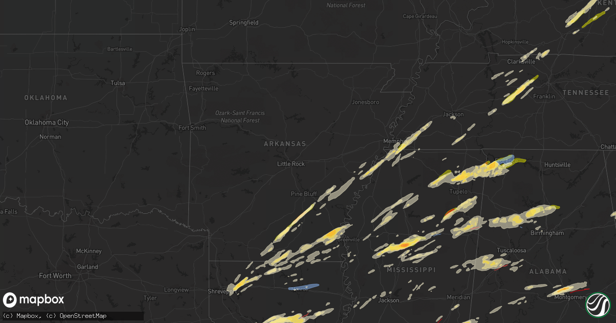
Hail Map in Arkansas on November 29, 2022
Get this storm
November 29 map
$229
one time, instant access
Download today. No call, no setup
Keep the $229
Bought the map and want the full workflow? Apply the entire $229 to a subscription within 7 days. None of it is wasted.
Every map, not just this one
This buys you this map. Subscription and you get every map we run, in the markets you choose from a few cities to whole states to nationwide. Plus real-time alerts the moment a storm fires.
Contact data
Name, contact info, occupancy, even credit band for addresses in the footprint. You go from where it hit to who to call.
Become the source they trust
Unlimited branding weather history reports on demand. You already have the documented answer ready for the property owner, and you are the one who showed up with it.
Property data and RoofTrace estimates
Pull up any address you have got, its value and the exact code rules for that jurisdiction, straight from One Click Code. Then RoofTrace estimates the squares, pitch, and roof value, priced the way you price.
Storm reports in Arkansas
Arkansas
| Date | Description |
|---|---|
| 11/29/20225:58 PM CST | Uprooted tree in town along with pea sized hail. |
| 11/29/20221:48 AM CST | At 748 PM CST, a severe thunderstorm was located near Old Milo, or near Hamburg, moving northeast at 50 mph. HAZARD...60 mph wind gusts and quarter size hail. SOURCE...Radar indicated. IMPACT...Hail damage to vehicles is expected. Expect wind damage to roofs, siding, and trees. This severe thunderstorm will be near... Snyder around 805 PM CST.Other locations impacted by this severe thunderstorm includeBlanchton. |
| 11/29/20221:21 AM CST | At 720 PM CST, a severe thunderstorm was located near De Witt, or 15 miles southeast of Stuttgart, moving northeast at 60 mph. HAZARD...60 mph wind gusts and quarter size hail. SOURCE...Radar indicated. IMPACT...Hail damage to vehicles is expected. Expect wind damage to roofs, siding, and trees. Locations impacted include... Holly Grove... Almyra... Palmer... Pine City... Almyra Airport... Casscoe... Crocketts Bluff... Lawrenceville... Ragtown... |
| 11/29/20221:16 AM CST | At 715 PM CST, a severe thunderstorm was located over St. Charles, or 10 miles north of White River National Wildlife Refuge, moving northeast at 50 mph. HAZARD...60 mph wind gusts and quarter size hail. SOURCE...Radar indicated. IMPACT...Hail damage to vehicles is expected. Expect wind damage to roofs, siding, and trees. Locations impacted include... Marianna, Marvell, Elaine, Helena-West Helena, St Francis National Park, Lexa, Rondo, Watkins Corner, Lake View, Lagrange, Wabash, Preston Place, Quarles, Hoop Spur, Westover, Wycamp, Latour, Turkey Scratch, Vineyard and Helena Crossing. |
| 11/29/202212:58 AM CST | At 657 PM CST, a severe thunderstorm was located near De Witt, or 14 miles west of White River National Wildlife Refuge, moving northeast at 50 mph. HAZARD...60 mph wind gusts and quarter size hail. SOURCE...Radar indicated. IMPACT...Hail damage to vehicles is expected. Expect wind damage to roofs, siding, and trees. Locations impacted include... Gillett... St. Charles... Palmer... De Witt... Indian Bay... Ethel... De Luce... Weber... Tichnor... Crocketts Bluff... Ragtown... Cross Roads in Monroe County... |
| 11/29/202212:50 AM CST | At 649 PM CST, a severe thunderstorm was located near Helena-West Helena, moving northeast at 50 mph. HAZARD...60 mph wind gusts and quarter size hail. SOURCE...Radar indicated. IMPACT...Hail damage to vehicles is expected. Expect wind damage to roofs, siding, and trees. Locations impacted include... Helena-West Helena, St Francis National Park, Tunica, Lexa, Phillipp, Dubbs, North Tunica, Dundee, Arkabutla, Robinsonville, Little Texas, Lake View, Preston Place, Quarles, Commerce, Austin, Jeffries, Peters, Wycamp and Latour. |
| 11/29/202212:43 AM CST | At 643 PM CST, a severe thunderstorm was located near Dermott, moving northeast at 50 mph. HAZARD...60 mph wind gusts and quarter size hail. SOURCE...Radar indicated. IMPACT...Hail damage to vehicles is expected. Expect wind damage to roofs, siding, and trees. Locations impacted include... Arkansas City... Lucca Landing... Jersey Point... McGehee... Masonville... Halley... |
| 11/29/202212:37 AM CST | At 637 PM CST, a severe thunderstorm was located near Dermott, moving northeast at 60 mph. HAZARD...60 mph wind gusts and quarter size hail. SOURCE...Radar indicated. IMPACT...Hail damage to vehicles is expected. Expect wind damage to roofs, siding, and trees. This severe thunderstorm will be near... Scott, Lamont and Winterville around 700 PM CST. Benoit around 705 PM CST.Other locations impacted by this severe thunderstorm include Beulahand Pace. |
| 11/29/202212:27 AM CST | At 627 PM CST, a severe thunderstorm was located over Herbine, or 11 miles southeast of Rison, moving northeast at 50 mph. HAZARD...60 mph wind gusts and quarter size hail. SOURCE...Radar indicated. IMPACT...Hail damage to vehicles is expected. Expect wind damage to roofs, siding, and trees. Locations impacted include... Star City... Grady... Nebo... Feenyville... Cottondale... Whitefield... Linwood... Cane Creek State Park... Little Bayou Meto Park... Madding... Woodville... Mt Elba... Langford... Douglas... Richardson... Herbine... Tarry... Cornerville... Cornerstone... Tamo... |
| 11/28/202211:56 PM CST | At 556 PM CST, a severe thunderstorm was located over Scott, or 14 miles southeast of Rohwer, moving east at 50 mph. HAZARD...60 mph wind gusts and half dollar size hail. SOURCE...Radar indicated. IMPACT...Hail damage to vehicles is expected. Expect wind damage to roofs, siding, and trees. This severe thunderstorm will be near... Benoit around 600 PM CST. Cleveland and Boyle around 620 PM CST. Renova around 625 PM CST. Ruleville around 635 PM CST. Drew around 640 PM CST. Parchman around 645 PM CST.Other locations impacted by this severe thunderstorm includeWinstonville, Beulah, Pace and Merigold. |
| 11/28/202211:52 PM CST | At 552 PM CST, a severe thunderstorm was located near Norphlet, moving northeast at 50 mph. HAZARD...60 mph wind gusts and quarter size hail. SOURCE...Radar indicated. IMPACT...Hail damage to vehicles is expected. Expect wind damage to roofs, siding, and trees. Locations impacted include... Warren... Hampton... Harrell... Hampton Municipal Airport... Ellisville... Weeks... Lanark... Banks... Tinsman... Woodberry... |
| 11/28/202211:05 PM CST | At 504 PM CST, a severe thunderstorm was located near Snyder, or 11 miles northeast of Hamburg, moving east at 50 mph. HAZARD...60 mph wind gusts and half dollar size hail. SOURCE...Radar indicated. IMPACT...Hail damage to vehicles is expected. Expect wind damage to roofs, siding, and trees. This severe thunderstorm will be near... Dermott around 525 PM CST. Mcmillan Corner around 530 PM CST.Other locations impacted by this severe thunderstorm includeBlanchton. |
| 11/28/20226:40 PM CST | A local report indicates 1.00 inch wind near 1 W STAR CITY |
| 11/28/20226:38 PM CST | Golf ball size hail was reported in dermott arkansas. |
| 11/28/20226:05 PM CST | A local report indicates 1.50 inch wind near TINSMAN |
All States Impacted by Hail Map on November 29, 2022
Cities Impacted by Hail Map on November 29, 2022
- Clarkson, KY
- Elizabethtown, KY
- Boston, KY
- Dickson, TN
- McEwen, TN
- Vanleer, TN
- Palmyra, TN
- Erin, TN
- Cumberland City, TN
- Cumberland Furnace, TN
- Campbellsville, KY
- Summersville, KY
- Meridian, MS
- Stonewall, MS
- Enterprise, MS
- Gattman, MS
- Starkville, MS
- Mississippi State, MS
- Millport, AL
- West Point, MS
- Aberdeen, MS
- Caledonia, MS
- Steens, MS
- Vernon, AL
- Sulligent, AL
- Cedarbluff, MS
- Hamilton, MS
- Columbus, MS
- Rossville, TN
- Ridgeland, MS
- Madison, MS
- Warren, AR
- Kingston Springs, TN
- Burns, TN
- Centerville, TN
- Nunnelly, TN
- White Bluff, TN
- Charlotte, TN
- Ashland City, TN
- Bon Aqua, TN
- Lobelville, TN
- Only, TN
- Farmerville, LA
- Hollandale, MS
- Cub Run, KY
- Leitchfield, KY
- Stamping Ground, KY
- Bardstown, KY
- Mount Eden, KY
- Sadieville, KY
- Mammoth Cave, KY
- Bonnieville, KY
- Waddy, KY
- Coxs Creek, KY
- Fairfield, KY
- New Haven, KY
- Sweeden, KY
- Bowling Green, KY
- Shelbyville, KY
- Taylorsville, KY
- Bloomfield, KY
- Munfordville, KY
- Hodgenville, KY
- Upton, KY
- Brownsville, KY
- Frankfort, KY
- Sonora, KY
- Bee Spring, KY
- Hornsby, TN
- Bethel Springs, TN
- Pocahontas, TN
- Selmer, TN
- Middleton, TN
- Hurricane Mills, TN
- Byhalia, MS
- Florence, AL
- Park City, KY
- Rocky Hill, KY
- Oakland, KY
- Smiths Grove, KY
- Nesbit, MS
- Southaven, MS
- Hernando, MS
- Coldwater, MS
- Falmouth, KY
- Georgetown, OH
- Hamersville, OH
- Felicity, OH
- Foster, KY
- Brooksville, KY
- Jackson, TN
- Townley, AL
- Berry, AL
- Hanceville, AL
- Bankston, AL
- Trafford, AL
- Oakman, AL
- Hayden, AL
- Fayette, AL
- Carbon Hill, AL
- Empire, AL
- Locust Fork, AL
- Jasper, AL
- Parrish, AL
- Dora, AL
- Warrior, AL
- Bremen, AL
- Cordova, AL
- Kennedy, AL
- Cullman, AL
- Crane Hill, AL
- Cleveland, AL
- Hamburg, AR
- Bastrop, LA
- Canmer, KY
- Hardyville, KY
- Horse Cave, KY
- Magnolia, KY
- Poplar Grove, AR
- El Dorado, AR
- Junction City, AR
- Ackerman, MS
- Greenwood, MS
- Coila, MS
- Carrollton, MS
- Falkner, MS
- Gravel Switch, KY
- Springfield, KY
- Lebanon, KY
- Harrodsburg, KY
- Nicholasville, KY
- Wilmore, KY
- Perryville, KY
- Mackville, KY
- Versailles, KY
- Saltillo, MS
- Winnsboro, LA
- Delhi, LA
- Scooba, MS
- West, MS
- Grady, AR
- Gould, AR
- Lexa, AR
- Crossett, AR
- Marion, LA
- Huttig, AR
- Morton, MS
- Forest, MS
- Lena, MS
- McCool, MS
- French Camp, MS
- Ethel, MS
- Weir, MS
- Baldwyn, MS
- Dumas, MS
- Booneville, MS
- Stewart, MS
- Saint Francisville, LA
- Angola, LA
- Woodville, MS
- Batchelor, LA
- Lettsworth, LA
- Monterey, LA
- Durant, MS
- Eutaw, AL
- Knoxville, AL
- Fairview, TN
- Lyles, TN
- Big Sandy, TN
- Stewart, TN
- Waverly, TN
- Tennessee Ridge, TN
- Coffeeville, MS
- Oakland, MS
- Water Valley, MS
- Tillatoba, MS
- Arkansas City, AR
- Lillie, LA
- Hermitage, AR
- Strong, AR
- Homer, LA
- Lake Village, AR
- Rohwer, AR
- Summerfield, LA
- Bernice, LA
- Spearsville, LA
- Haynesville, LA
- McGehee, AR
- Greenville, MS
- Dermott, AR
- Benoit, MS
- Monticello, AR
- Montrose, AR
- Chatham, MS
- Oxford, MS
- Pontotoc, MS
- Marietta, MS
- Belmont, MS
- Fulton, MS
- Golden, MS
- Ecru, MS
- Cherokee, AL
- New Site, MS
- Blue Springs, MS
- Muscle Shoals, AL
- Iuka, MS
- New Albany, MS
- Tuscumbia, AL
- Guntown, MS
- Thaxton, MS
- Tupelo, MS
- Etta, MS
- Red Bay, AL
- Tishomingo, MS
- Sheffield, AL
- Russellville, AL
- Dennis, MS
- Leighton, AL
- Myrtle, MS
- Marianna, AR
- Linden, TN
- Moundville, AL
- Greensboro, AL
- Sardis, TN
- Finger, TN
- Reagan, TN
- Enville, TN
- Adamsville, TN
- Kilmichael, MS
- Tibbie, AL
- Uriah, AL
- Fruitdale, AL
- State Line, MS
- Deer Park, AL
- Jackson, AL
- Wagarville, AL
- Gainestown, AL
- Leroy, AL
- Chatom, AL
- Portland, AR
- Parkdale, AR
- Olive Branch, MS
- Banks, AR
- Yazoo City, MS
- Vicksburg, MS
- Carthage, MS
- Hemphill, TX
- Clarksville, TN
- Dumas, AR
- Marvell, AR
- Decatur, MS
- Union, MS
- Conehatta, MS
- Barksdale Afb, LA
- Minden, LA
- Haughton, LA
- Sibley, LA
- Elm Grove, LA
- Doyline, LA
- Athens, LA
- Princeton, LA
- Bossier City, LA
- Jones, AL
- Plantersville, AL
- Marion, AL
- Billingsley, AL
- Selma, AL
- Shuqualak, MS
- De Kalb, MS
- Preston, MS
- Ripley, MS
- Birmingham, AL
- Maben, MS
- Mathiston, MS
- Prairie, MS
- Quinton, AL
- Fosters, AL
- Gordo, AL
- Boligee, AL
- Macon, MS
- Aliceville, AL
- Ralph, AL
- Emelle, AL
- Belzoni, MS
- Tchula, MS
- Prattville, AL
- Downsville, LA
- Southside, TN
- Cunningham, TN
- Olmstead, KY
- Adairville, KY
- Franklin, KY
- Springfield, TN
- Cedar Hill, TN
- Russellville, KY
- Clinton, MS
- Jackson, MS
- Paris, KY
- Lexington, KY
- Lexington, MS
- Cruger, MS
- Vaiden, MS
- Eupora, MS
- Winona, MS
- Sidon, MS
- Pheba, MS
- Silver City, MS
- De Witt, AR
- Ethel, AR
- Gillett, AR
- Holly Grove, AR
- Clarendon, AR
- Saint Charles, AR
- Stuttgart, AR
- Duncanville, AL
- Centreville, AL
- Orrville, AL
- Safford, AL
- Alberta, AL
- Philipp, MS
- Schlater, MS
- Sunflower, MS
- Charleston, MS
- Holcomb, MS
- Cascilla, MS
- Minter City, MS
- Parsons, TN
- Decaturville, TN
- Fruithurst, AL
- Rockmart, GA
- Muscadine, AL
- Tallapoosa, GA
- Cedartown, GA
- Buchanan, GA
- Stanton, TN
- Robinsonville, MS
- West Helena, AR
- Helena, AR
- Germantown, TN
- Eads, TN
- Memphis, TN
- Tunica, MS
- Collierville, TN
- Cordova, TN
- Oakland, TN
- Dundee, MS
- Mason, TN
- Horn Lake, MS
- Lake Cormorant, MS
- Walls, MS
- Somerville, TN
- Arlington, TN
- Monroe, LA
- Sterlington, LA
- Vardaman, MS
- Calhoun City, MS
- Gore Springs, MS
- Walnut Grove, MS
- Guthrie, KY
- Allensville, KY
- Buhl, AL
- Tuscaloosa, AL
- Bay Springs, MS
- Paulding, MS
- Enid, MS
- Utica, MS
- Edwards, MS
- Seminary, MS
- Richton, MS
- Kelly, LA
- Winnfield, LA
- Goldonna, LA
- Natchitoches, LA
- Atlanta, LA
- Sikes, LA
- Dodson, LA
- Olla, LA
- Grayson, LA
- Columbia, LA
- Tullos, LA
- Robeline, LA
- Provencal, LA
- Nettleton, MS
- Hampton, AR
- Harrell, AR
- Gilbert, LA
- Collins, MS
- Columbia, MS
- Sumrall, MS
- Monticello, MS
- Prentiss, MS
- Bassfield, MS
- Oak Vale, MS
- Carson, MS
- Foxworth, MS
- Jayess, MS
- Almyra, AR
- Gibsland, LA
- Dubberly, LA
- Okolona, MS
- Amory, MS
- Liberty, MS
- Summit, MS
- Smithdale, MS
- Magnolia, MS
- Kosciusko, MS
- Baldwin, LA
- Franklin, LA
- Jeanerette, LA
- Morgan City, LA
- Waynesboro, MS
- Shubuta, MS
- Melvin, AL
- Laurel, MS
- Gilbertown, AL
- Sallis, MS
- Marion Junction, AL
- Thomaston, AL
- Catherine, AL
- Mccomb, MS
- Toxey, AL
- Silas, AL
- Quitman, MS
- Needham, AL
- Star City, AR
- New Edinburg, AR
- Rison, AR
- Many, LA
- Belmont, LA
- Zwolle, LA
- Marthaville, LA
- Centreville, MS
- Bogue Chitto, MS
- Gloster, MS
- Ruth, MS
- Heflin, LA
- Huntington, TX
- Goodman, MS
- Louisville, MS
- Ellisville, MS
- Cotton Valley, LA
- Adamsville, AL
- Graysville, AL
- Mantee, MS
- Woodland, MS
- Houston, MS
- Smithville, MS
- Tremont, MS
- Carriere, MS
- Poplarville, MS
- Bogalusa, LA
- West Monroe, LA
- Benton, MS
- Pickens, MS
- Ruleville, MS
- Courtland, MS
- Pope, MS
- Tutwiler, MS
- Drew, MS
- Louann, AR
- Yorktown, AR
- Greensburg, LA
- Brent, AL
- Altheimer, AR
- Itta Bena, MS
- Petal, MS
- Bolton, MS
- Sweet Water, AL
- Linden, AL
- Milam, TX
- Broaddus, TX
- San Augustine, TX
- Noble, LA
- Bronson, TX
- Indianola, MS
- Pelahatchie, MS
- Wisner, LA
- Franklinton, LA
- Sandy Hook, MS
- Angie, LA
- Tylertown, MS
- Glen Allan, MS
- Wetumpka, AL
- Autaugaville, AL
- Coosada, AL
- Deatsville, AL
- Millbrook, AL
- Elmore, AL
- Hattiesburg, MS
- Pleasant Hill, LA
- Fort Necessity, LA
- Zavalla, TX
- Montgomery, LA
- Georgetown, LA
- Campti, LA
- Newellton, LA
- Etoile, TX
- Dubach, LA
- Perkinston, MS
- Booth, AL
- Lowndesboro, AL
- Montgomery, AL
- Eclectic, AL
- Tallassee, AL
- Wilmot, AR
- Hollywood, AL
- Cave City, KY
- Adams, TN
- Scottsboro, AL
- Fackler, AL
- Joelton, TN
- Calhoun, LA
- Oak Ridge, LA
- Collinston, LA
- Rayville, LA
- Killen, AL
- Blue Mountain, MS
- Town Creek, AL
- Athens, AL
- Rogersville, AL
- Oneonta, AL
- Greensburg, KY
- Salvisa, KY
- Lawrenceburg, KY
- Bagdad, KY
- Oberlin, LA
- Heidelberg, MS
- Stringer, MS
- Akron, AL
- Newhebron, MS
- Magee, MS


