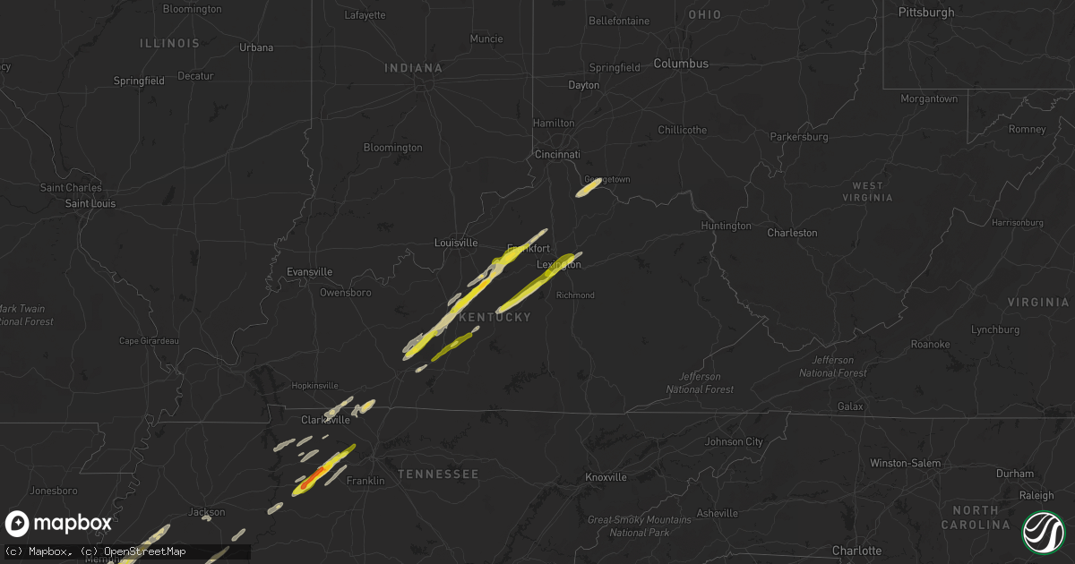
Hail Map on November 29, 2022
Get this storm
November 29 map
$229
one time, instant access
Download today. No call, no setup
Keep the $229
Bought the map and want the full workflow? Apply the entire $229 to a subscription within 7 days. None of it is wasted.
Every map, not just this one
This buys you this map. Subscription and you get every map we run, in the markets you choose from a few cities to whole states to nationwide. Plus real-time alerts the moment a storm fires.
Contact data
Name, contact info, occupancy, even credit band for addresses in the footprint. You go from where it hit to who to call.
Become the source they trust
Unlimited branding weather history reports on demand. You already have the documented answer ready for the property owner, and you are the one who showed up with it.
Property data and RoofTrace estimates
Pull up any address you have got, its value and the exact code rules for that jurisdiction, straight from One Click Code. Then RoofTrace estimates the squares, pitch, and roof value, priced the way you price.
States Impacted by Hail Map on November 29, 2022
Storm reports
Georgia
| Date | Description |
|---|---|
| 11/29/20224:13 AM CST | Tree down on judkin mill rd |
| 11/29/20223:45 AM CST | Tree down at west point rd and ann murphy rd. |
| 11/29/20223:30 AM CST | Tree down on turner st near n greenwood st. |
| 11/29/20223:26 AM CST | Corrects previous tstm wnd dmg report from 1 se wares crossroads. Tree down on mooty bridge rd. Near concord dr. |
| 11/29/20223:20 AM CST | Power line down at the 567 block of rock-a-way rd |
| 11/29/20223:08 AM CST | Tree down at andrew bailey rd near lafayette ct. |
| 11/29/20223:03 AM CST | Tree down along corinth rd near bryant boys rd. |
| 11/29/20223:02 AM CST | 2 trees down along heery rd. One at russel cir and one westside school rd. |
| 11/29/20223:02 AM CST | Power lines down along old corinth rd near smokey rd. |
| 11/29/20223:00 AM CST | Tree down along handy rd near boy scout rd. |
| 11/29/20222:59 AM CST | Two trees down on newnan lakes blvd just outside of vinings at newnan lakes apartments. |
| 11/29/20222:40 AM CST | Tree down on house at chief ct... No injuries |
| 11/29/20222:29 AM CST | Tree down at valley grove rd at cave spring rd near cedartown. |
| 11/29/20222:26 AM CST | Tree and power line down at hwy 166 and antiock church rd... Just outside bowden |
Louisiana
| Date | Description |
|---|---|
| 11/29/20225:01 PM CST | Report from gas station at the intersection of highway 371 and main street. |
| 11/29/20225:00 PM CST | Roof blown off chicken house. Also... Light pole down along with several trees on middle road northeast of dubberly. |
| 11/29/20224:28 PM CST | A local report indicates 1.75 inch wind near NATCHITOCHES |
| 11/29/20224:20 PM CST | Correction...public reports hail half dollar to golfball size in hagewood community. |
| 11/29/20224:20 PM CST | Public reports hail up to half dollar size in hagewood community. |
| 11/29/20224:11 PM CST | A local report indicates 1.50 inch wind near ROBELINE |
| 11/29/20224:08 PM CST | Roof blown off a home in the holum community. |
| 11/29/20224:00 PM CST | Ksla-tv viewer reports hail ranging from nickel to quarter size near many... La. |
| 11/29/20223:55 PM CST | Social media photo of ping pong size hail east of zwolle along louisiana state hwy 120. |
| 11/29/20223:39 PM CST | Nickel to quarter size hail southwest of zwolle along toledo bend reservoir. |
| 11/29/20225:14 AM CST | At 1114 PM CST, a severe thunderstorm was located near Start, moving east at 55 mph. HAZARD...60 mph wind gusts and quarter size hail. SOURCE...Radar indicated. IMPACT...Hail damage to vehicles is expected. Expect wind damage to roofs, siding, and trees. This severe thunderstorm will be near... Goodwill around 1140 PM CST. Darnell around 1145 PM CST. Transylvania around 1200 AM CST. Lake Providence around 1205 AM CST.Other locations impacted by this severe thunderstorm include Forest,Pioneer, Oak Ridge and Epps. |
| 11/28/202211:57 PM CST | At 557 PM CST, a severe thunderstorm was located 11 miles southwest of Campti, or 12 miles northwest of Natchitoches, moving northeast at 50 mph. HAZARD...60 mph wind gusts and half dollar size hail. SOURCE...Radar indicated. IMPACT...Hail damage to vehicles is expected. Expect wind damage to roofs, siding, and trees. Locations impacted include... Natchitoches, Campti, Allen, Clarence, Powhatan, Black Lake, Grand Ecore, Clear Lake and Creston. |
| 11/28/202211:35 PM CST | At 535 PM CST, a severe thunderstorm was located 7 miles northwest of Olla, or 14 miles southwest of Columbia, moving northeast at 45 mph. HAZARD...60 mph wind gusts and half dollar size hail. SOURCE...Radar indicated. IMPACT...Hail damage to vehicles is expected. Expect wind damage to roofs, siding, and trees. Locations impacted include... Columbia, Olla, Clarks, Grayson, Urania, Sikes, Spaulding, Burlington, Riverton, Standard and Kelly. |
| 11/28/202211:24 PM CST | At 524 PM CST, a severe thunderstorm was located over Newman, or 12 miles southeast of Vicksburg, moving northeast at 45 mph. HAZARD...60 mph wind gusts and quarter size hail. SOURCE...Radar indicated. IMPACT...Hail damage to vehicles is expected. Expect wind damage to roofs, siding, and trees. This severe thunderstorm will be near... Edwards around 535 PM CST. Bolton around 545 PM CST. Clinton and Brownsville around 550 PM CST. Pocahontas around 600 PM CST.Other locations impacted by this severe thunderstorm include Mound,Learned and Delta. |
| 11/28/202211:01 PM CST | At 500 PM CST, a severe thunderstorm was located 7 miles southwest of Winnfield, moving northeast at 45 mph. HAZARD...60 mph wind gusts and half dollar size hail. SOURCE...Radar indicated. IMPACT...Hail damage to vehicles is expected. Expect wind damage to roofs, siding, and trees. Locations impacted include... Winnfield, Calvin, Atlanta, Sikes, Joyce and Hudson. |
| 11/28/202210:58 PM CST | At 458 PM CST, a severe thunderstorm was located over Doyline, or 9 miles southwest of Minden, moving northeast at 55 mph. HAZARD...60 mph wind gusts and half dollar size hail. SOURCE...Radar indicated. IMPACT...Hail damage to vehicles is expected. Expect wind damage to roofs, siding, and trees. Locations impacted include... Minden, Homer, Haughton, Haynesville, Sibley, Doyline, Dubberly, Dixie Inn, Shongaloo, Eastwood, Evergreen, Lisbon, Leton, Curtis, Fillmore, Bodcau, Plum Orchard Landing, Gilark, Noles Landing and Lake Bistineau North. |
| 11/28/202210:53 PM CST | 56 kt |
| 11/28/202210:12 PM CST | At 412 PM CST, a severe thunderstorm was located 11 miles west of Natchitoches, moving northeast at 60 mph. HAZARD...Golf ball size hail and 60 mph wind gusts. SOURCE...Radar indicated. IMPACT...People and animals outdoors will be injured. Expect hail damage to roofs, siding, windows, and vehicles. Expect wind damage to roofs, siding, and trees. Locations impacted include... Natchitoches, Winnfield, Campti, Allen, Provencal, Natchez, Clarence, Goldonna, Calvin, Robeline, Atlanta, Powhatan, Grand Ecore, St. Maurice, Black Lake, Clear Lake, Creston, Hagewood and Bermuda. |
| 11/28/20229:59 PM CST | At 358 PM CST, a severe thunderstorm was located near Rosefield, or 15 miles south of Columbia, moving northeast at 55 mph. HAZARD...60 mph wind gusts and half dollar size hail. SOURCE...Radar indicated. IMPACT...Hail damage to vehicles is expected. Expect wind damage to roofs, siding, and trees. This severe thunderstorm will be near... Rosefield around 405 PM CST. Sherwood around 410 PM CST. Enterprise around 415 PM CST. Jigger around 425 PM CST. Winnsboro and Wisner around 430 PM CST.Other locations impacted by this severe thunderstorm include Gilbertand Sicily Island. |
| 11/28/20229:35 PM CST | At 334 PM CST, a severe thunderstorm was located 7 miles northeast of Winnfield, moving east at 45 mph. HAZARD...60 mph wind gusts and half dollar size hail. SOURCE...Radar indicated. IMPACT...Hail damage to vehicles is expected. Expect wind damage to roofs, siding, and trees. Locations impacted include... Winnfield, Clarks, Grayson, Dodson, Sikes, Joyce, Vixen, Hudson and Kelly. |
| 11/28/20227:32 PM CST | Tornado was spotted nw of mound... La. Pictures sent via twitter. |
| 11/28/20227:32 PM CST | The tornado was confirmed from images and video provided by multiple storm chasers via social media. No damage was found during a nws storm survey. |
| 11/28/20227:18 PM CST | At 118 PM CST, a severe thunderstorm was located over Moreauville, moving northeast at 30 mph. HAZARD...Quarter size hail. SOURCE...Radar indicated. IMPACT...Damage to vehicles is expected. Locations impacted include... Moreauville, Bordelonville, Cottonport, Mansura, Plaucheville, Big Bend, Lake Ophelia National Wildlife Refuge and Hamburg. |
| 11/28/20226:03 PM CST | *** 1 inj *** corrects previous tornado report from 6 se clarks. This ef3 tornado traveled roughly 8 miles on an east northeast track through rural portions of southeas |
| 11/28/20226:03 PM CST | Structural damage reported along la highway 126. Poe radar showed a tds continuing on for some distance northeast of this general location. |
Mississippi
| Date | Description |
|---|---|
| 11/29/20225:45 PM CST | Tree downed on house from confirmed tornado. |
| 11/29/20225:21 PM CST | This corrects the previous report of thunderstorm wind damage from 5 w chester. Tree down on natchez trace pkwy blocking both directions. Just south of us-82... In webs |
| 11/29/20225:16 PM CST | Reported damage to news room from confirmed tornado. |
| 11/29/20225:16 PM CST | Reports of transformer on fire and multiple trees downed as well as a few power poles snapped. |
| 11/29/20225:16 PM CST | Storm chasers observed and recorded a large wedge tornado on hwy 42 tracking e-se out of bassfield. Several downed trees and power flashes were observed as well. |
| 11/29/20225:16 PM CST | Tree down on natchez trace pkwy blocking both directions. Just south of us-82... Still in webster county. Report from spotternetwork. |
| 11/29/20225:16 PM CST | Trees downed. |
| 11/29/20225:15 PM CST | Quarter sized hail reported. |
| 11/29/20225:14 PM CST | This tornado touched down near the intersection of bassfield cemetery road and mcleod dr and tracked ene for almost 4 miles before dissipating just beyond hosey mikell |
| 11/29/20225:14 PM CST | Corrects previous tornado report from 4 nne bywy. Tree downed on house from confirmed tornado. |
| 11/29/20225:11 PM CST | This tornado touched down near the intersection of mississippi highway 9 and maddox road where a few trees were snapped or damaged. The tornado moved northeast and cros |
| 11/29/20225:11 PM CST | Building was damaged and rv was rolled along hester road. |
| 11/29/20225:10 PM CST | Corrects previous report: mhp confirmed tornado on hwy 35 marion jeff davis line. |
| 11/29/20225:10 PM CST | Mobile home was damaged. Porch was destroyed and there was damage to a truck on the property. |
| 11/29/20225:10 PM CST | Power poles were snapped along hwy 35 s of bassfield... Ms. |
| 11/29/20225:10 PM CST | Trees down reported on gates rd. |
| 11/29/20225:08 PM CST | This brief tornado touched down just off ebenezer church road. A few trees were uprooted and damaged. |
| 11/29/20225:05 PM CST | Mhp confirmed tornado on hwy 35 marion jeff davis line. |
| 11/29/20225:05 PM CST | Quarter to golf ball hail in the carson community. |
| 11/29/20224:40 PM CST | Reports of tornado. Debris reported with possible structural damage. |
| 11/29/20224:40 PM CST | Corrects previous tornado report from 2 sw tilton. Reports of tornado. Debris reported with possible structural damage. |
| 11/29/20224:25 PM CST | This tornado touched down near the intersection of tilton road and givens road and moved northeast along tilton road. Most of the damage was uprooted and damaged trees. |
| 11/29/20223:24 PM CST | Tornado was reported northeast of west. |
| 11/29/20223:22 PM CST | Large golf ball size hail was reported near the thompson community. |
| 11/29/20223:20 PM CST | A tree was blown down on mulberry street in vaiden. Transformer was down as well. |
| 11/29/20223:11 PM CST | A tree was reported down near the amite and franklin cos line along hwy 567. |
| 11/29/20223:10 PM CST | Quarter to golf ball hail in and around bassfield. |
| 11/29/20223:06 PM CST | Storm chaser submitted a picture of 2-inch size hail on facebook. |
| 11/29/20222:45 PM CST | 1.25 hail reported in tchula ms. |
| 11/29/20222:33 PM CST | Corrects previous hail report from tchula. Hail report. |
| 11/29/20222:32 PM CST | Corrects previous hail report from tchula. 1.25 hail reported in tchula ms. |
| 11/29/202212:45 PM CST | Several trees down near and around the intersections of highway 30 highway 365. Report of roof damage to a church and a barn south of this intersection. |
| 11/29/202212:42 PM CST | About 50 pine trees were snapped off near the intersection of highway 371 and highway 366 in marietta. All trees were blown to the southeast. |
| 11/29/202212:30 PM CST | Dime to quarter-sized hail. |
| 11/29/202212:23 PM CST | Corrects previous tstm wnd dmg report time from marietta. About 50 pine trees were snapped off near the intersection of highway 371 and highway 366 in marietta. All tre |
| 11/29/202212:12 PM CST | Trees down on structure. Twitter report. |
| 11/29/202212:08 PM CST | Roof partially removed from house on county road 5141 south of booneville. Time is radar estimated. |
| 11/29/202212:00 PM CST | Two inch hail fell in the carolina community. |
| 11/29/202211:40 AM CST | A local report indicates 1.00 inch wind near 1 E NEW ALBANY |
| 11/29/20226:55 AM CST | At 1254 PM CST, a severe thunderstorm was located over Indianola, moving northeast at 65 mph. HAZARD...60 mph wind gusts and quarter size hail. SOURCE...Radar indicated. IMPACT...Hail damage to vehicles is expected. Expect wind damage to roofs, siding, and trees. This severe thunderstorm will be near... Sunflower and Blaine around 105 PM CST. Minter City and Sunnyside around 120 PM CST.Other locations impacted by this severe thunderstorm include Schlaterand Doddsville. |
| 11/29/20225:30 AM CST | At 1130 AM CST, a severe thunderstorm was located over New Albany, moving northeast at 40 mph. HAZARD...60 mph wind gusts and quarter size hail. SOURCE...Radar indicated. IMPACT...Hail damage to vehicles is expected. Expect wind damage to roofs, siding, and trees. Locations impacted include... Booneville, New Albany, Ripley, Baldwyn, Jumpertown, Keownville, Wheeler, Myrtle, Dumas, Shari, Poolville, Graham, Jericho, Branyan, Ellistown, Old Myrtle, Collinstown, Pumpkin Center, Baker and Geeville. |
| 11/29/20225:14 AM CST | At 1113 PM CST, a severe thunderstorm was located near Liberty, moving east at 40 mph. HAZARD...60 mph wind gusts and quarter size hail. SOURCE...Radar indicated. IMPACT...Hail damage to vehicles is expected. Expect wind damage to roofs, siding, and trees. Locations impacted include... Liberty. |
| 11/29/20225:13 AM CST | At 1113 PM CST, a severe thunderstorm was located 10 miles south of Cherokee, moving east at 45 mph. HAZARD...60 mph wind gusts. SOURCE...Radar indicated. IMPACT...Expect damage to roofs, siding, and trees. Locations impacted include... Florence, Muscle Shoals, Russellville, Sheffield, Tuscumbia, Red Bay, Phil Campbell, Killen, Town Creek and Cherokee. |
| 11/29/20225:11 AM CST | At 1110 AM CST, a severe thunderstorm was located near Montpelier, moving northeast at 50 mph. HAZARD...60 mph wind gusts and quarter size hail. SOURCE...Radar indicated. IMPACT...Hail damage to vehicles is expected. Expect wind damage to roofs, siding, and trees. Locations impacted include... Aberdeen, Houston, Okolona, Prairie, Trebloc, Woodland, Sparta, Van Vleet, Parkersburg, Egypt, Tabbville, McCondy, Anchor, Buena Vista and Leotis. |
| 11/29/20224:26 AM CST | At 1025 PM CST, a severe thunderstorm was located over Baldwyn, moving east at 50 mph. HAZARD...60 mph wind gusts and quarter size hail. SOURCE...Radar indicated. IMPACT...Hail damage to vehicles is expected. Expect wind damage to roofs, siding, and trees. Locations impacted include... Baldwyn, Tishomingo State Park, Saltillo, Guntown, Belmont, Tishomingo, Burton, Wheeler, Pratts Friendship, Sandy Springs, Blair, Marietta, Blue Springs, Golden, Paden, Graham, Thrasher, Jericho, Branyan and Dennis. |
| 11/29/20224:14 AM CST | At 1013 PM CST, a severe thunderstorm was located 8 miles west of Wakefield, or 9 miles northwest of St. Francisville, moving east at 40 mph. HAZARD...60 mph wind gusts and quarter size hail. SOURCE...Radar indicated. IMPACT...Hail damage to vehicles is expected. Expect wind damage to roofs, siding, and trees. Locations impacted include... Wakefield and Spillman. |
| 11/29/20224:09 AM CST | At 1009 AM CST, a severe thunderstorm was located over Charleston, moving northeast at 45 mph. HAZARD...60 mph wind gusts and quarter size hail. SOURCE...Radar indicated. IMPACT...Hail damage to vehicles is expected. Expect wind damage to roofs, siding, and trees. Locations impacted include... Water Valley, Charleston, George Payne State Park, Coffeeville, Pope, Springdale, Enid, Paynes, Velma, Scobey, Oakland, Courtland, Shuford, Pine Valley, Tillatoba and Eureka Springs. |
| 11/29/20223:58 AM CST | At 958 PM CST, a severe thunderstorm was located near Mcmillan, or 8 miles northwest of Louisville, moving northeast at 50 mph. HAZARD...60 mph wind gusts and quarter size hail. SOURCE...Radar indicated. IMPACT...Hail damage to vehicles is expected. Expect wind damage to roofs, siding, and trees. This severe thunderstorm will be near... Craig Springs around 1015 PM CST. Longview around 1020 PM CST. Starkville and Oktoc around 1025 PM CST. Sessums around 1035 PM CST. Bent Oak around 1045 PM CST.Other locations impacted by this severe thunderstorm include Sturgisand Artesia. |
| 11/29/20223:50 AM CST | At 949 PM CST, a severe thunderstorm was located near Fort Adams, or 16 miles north of St. Francisville, moving northeast at 45 mph. HAZARD...60 mph wind gusts and quarter size hail. SOURCE...Radar indicated. IMPACT...Hail damage to vehicles is expected. Expect wind damage to roofs, siding, and trees. Locations impacted include... Centreville, Woodville, Fort Adams and Crosby. |
| 11/29/20223:00 AM CST | At 900 PM CST, a severe thunderstorm was located near Prospect, moving northeast at 45 mph. HAZARD...60 mph wind gusts and quarter size hail. SOURCE...Radar indicated. IMPACT...Hail damage to vehicles is expected. Expect wind damage to roofs, siding, and trees. This severe thunderstorm will be near... Neshoba around 910 PM CST. Little Rock around 915 PM CST. House, Herbert Springs and Bethsaida around 920 PM CST. Damascus and Forestdale around 930 PM CST. Liberty around 935 PM CST. Bluff Springs around 940 PM CST. De Kalb around 945 PM CST.Other locations impacted by this severe thunderstorm include Tucker. |
| 11/29/20222:29 AM CST | Damage to trees along highway 57 to the south of johnson creek baptist church. |
| 11/29/20222:27 AM CST | The tornado began near hwy 57 in greene county ms where several softwood tree trunks were snapped... Then took a northeast track producing damage along nursery road. Th |
| 11/29/20221:53 AM CST | An ice skating rink canopy and concert stage was damaged in downtown columbia and a large christmas tree was downed at bluff street park. |
| 11/29/20221:51 AM CST | This brief tornado touched down just north of ten mile creek road in southern marion county where it initially produced minor damage in a stand of trees. An outbuilding |
| 11/29/20221:25 AM CST | Sherriffs office report trees down across county. |
| 11/29/20221:06 AM CST | At 706 PM CST, a cluster of severe thunderstorms were located over Walls, or near Horn Lake, moving northeast at 60 mph. HAZARD...Quarter size hail. SOURCE...Radar indicated. IMPACT...Damage to vehicles is expected. Locations impacted include... Bartlett, Southaven, Collierville, Germantown, Olive Branch, Horn Lake, Hernando, T O Fuller State Park, Cordova, Memphis, Lakeland, Arlington, Walls, Horseshoe Lake, Lake Cormorant, Southwest Memphis, Ellendale, Eudora, Lewisburg and Whitehaven. |
| 11/29/202212:54 AM CST | Spotter reports tree damage along i-55 south of magnolia. |
| 11/29/202212:42 AM CST | An ef1 tornado with maximum winds of 100 mph and a maximum width of 250 yards touched down on pilgrims rest road southeast of liberty... Ms and ended on centerville roa |
| 11/29/202212:40 AM CST | At 640 PM CST, a severe thunderstorm was located over Goshen Springs, or 11 miles southeast of Canton, moving east at 55 mph. HAZARD...Ping pong ball size hail and 60 mph wind gusts. SOURCE...Radar indicated. IMPACT...People and animals outdoors will be injured. Expect hail damage to roofs, siding, windows, and vehicles. Expect wind damage to roofs, siding, and trees. This severe thunderstorm will be near... Leesburg and Farmhaven around 650 PM CST. Ludlow and Forkville around 655 PM CST. Tuscola around 705 PM CST. Edinburg, Dowdville and Madden around 720 PM CST. Pearl River and Dixon around 725 PM CST. Philadelphia around 730 PM CST.Other locations impacted by this severe thunderstorm include Lena,Walnut Grove, Sebastopol and Standing Pine. |
| 11/29/202212:12 AM CST | At 612 PM CST, a severe thunderstorm was located near Pocahontas, or near Clinton, moving northeast at 45 mph. HAZARD...60 mph wind gusts and half dollar size hail. SOURCE...Radar indicated. IMPACT...Hail damage to vehicles is expected. Expect wind damage to roofs, siding, and trees. This severe thunderstorm will be near... Ridgeland and Annandale around 620 PM CST. Madison and Gluckstadt around 625 PM CST. Canton around 630 PM CST. Fannin around 635 PM CST. Goshen Springs and Pisgah around 640 PM CST. Sharon around 645 PM CST. Ludlow and Farmhaven around 655 PM CST. |
| 11/28/202211:45 PM CST | At 544 PM CST, a severe thunderstorm was located over Arkansas City, or 12 miles south of Rohwer, moving northeast at 50 mph. HAZARD...60 mph wind gusts and quarter size hail. SOURCE...Radar indicated. IMPACT...Hail damage to vehicles is expected. Expect wind damage to roofs, siding, and trees. Locations impacted include... Arkansas City... Lucca Landing... Jersey Point... McGehee... Masonville... Halley... |
| 11/28/202211:28 PM CST | Trees and branches down in the area. |
| 11/28/202211:27 PM CST | At 527 PM CST, a severe thunderstorm was located over Kolola Springs, or near Columbus AFB, moving east at 35 mph. HAZARD...Ping pong ball size hail and 60 mph wind gusts. SOURCE...Radar indicated. IMPACT...People and animals outdoors will be injured. Expect hail damage to roofs, siding, windows, and vehicles. Expect wind damage to roofs, siding, and trees. This severe thunderstorm will be near... Caledonia around 535 PM CST. |
| 11/28/202211:07 PM CST | Roof blown off house. |
| 11/28/202211:02 PM CST | At 502 PM CST, a severe thunderstorm was located near Ladelle, or 13 miles northeast of Hamburg, moving northeast at 45 mph. HAZARD...60 mph wind gusts and quarter size hail. SOURCE...Radar indicated. IMPACT...Hail damage to vehicles is expected. Expect wind damage to roofs, siding, and trees. Locations impacted include... Dermott... Rohwer... Arkansas City... Tillar... Watson... Jersey Point... Lucca Landing... McGehee... Kelso... Prairie Grove... Jerome... Baxter... Halley... Masonville... Collins... McArthur... |
| 11/28/202210:54 PM CST | Tree branches down in the area. |
| 11/28/202210:52 PM CST | Trees and sheet metal down in the area. |
| 11/28/202210:50 PM CST | At 449 PM CST, a severe thunderstorm was located near Kilmichael, or 15 miles east of Winona, moving east at 60 mph. HAZARD...Ping pong ball size hail and 60 mph wind gusts. SOURCE...Radar indicated. IMPACT...People and animals outdoors will be injured. Expect hail damage to roofs, siding, windows, and vehicles. Expect wind damage to roofs, siding, and trees. This severe thunderstorm will be near... Eupora around 500 PM CST. Chester around 505 PM CST. Mathiston, Sherwood and Reform around 510 PM CST. Maben around 515 PM CST. Pheba around 520 PM CST. Starkville and Longview around 525 PM CST. Muldrow and Sessums around 535 PM CST.Other locations impacted by this severe thunderstorm includeWalthall. |
| 11/28/202210:45 PM CST | Trees and branches down in the area. |
| 11/28/202210:40 PM CST | Possible tornado damage off mount zion road. Barn damaged. |
| 11/28/202210:37 PM CST | Tree branches down in the area. |
| 11/28/202210:30 PM CST | Golf ball size hail reported by fire dept near baldywn. |
| 11/28/202210:30 PM CST | Tweet from kim gray. |
| 11/28/202210:26 PM CST | Report from mping: 1-inch tree limbs broken; shingles blown off. |
| 11/28/202210:10 PM CST | At 409 PM CST, a severe thunderstorm was located over Black Hawk, moving northeast at 60 mph. HAZARD...60 mph wind gusts and quarter size hail. SOURCE...Radar indicated. IMPACT...Hail damage to vehicles is expected. Expect wind damage to roofs, siding, and trees. This severe thunderstorm will be near... Coila around 415 PM CST. North Carrollton around 425 PM CST. Winona around 430 PM CST. Duck Hill around 440 PM CST. Sweatman and Lodi around 445 PM CST. Misterton around 450 PM CST.Other locations impacted by this severe thunderstorm includeCarrollton. |
| 11/28/202210:09 PM CST | At 409 PM CST, a severe thunderstorm was located over Jayess, or 15 miles northwest of Kokomo, moving east at 35 mph. HAZARD...60 mph wind gusts and quarter size hail. SOURCE...Radar indicated. IMPACT...Hail damage to vehicles is expected. Expect wind damage to roofs, siding, and trees. This severe thunderstorm will be near... Holly Springs and Tilton around 425 PM CST. Oak Vale and Morgantown around 430 PM CST. Goss around 435 PM CST. Society Hill around 440 PM CST. Bunker Hill around 445 PM CST. Carson around 450 PM CST. Melba around 500 PM CST.Other locations impacted by this severe thunderstorm includeBassfield. |
| 11/28/202210:00 PM CST | Four power poles downed in the inverness area. |
| 11/28/20229:38 PM CST | At 337 PM CST, a severe thunderstorm was located over Summit, or over Mccomb, moving east at 35 mph. HAZARD...60 mph wind gusts and quarter size hail. SOURCE...Radar indicated. IMPACT...Hail damage to vehicles is expected. Expect wind damage to roofs, siding, and trees. Locations impacted include... Mccomb and Summit. This includes Interstate 55 in Mississippi between mile markers 15and 24. |
| 11/28/20229:21 PM CST | Power pole down reported by ema. |
| 11/28/20229:14 PM CST | Trees down near huddleston road and hwy 494. |
| 11/28/20229:14 PM CST | At 314 PM CST, a severe thunderstorm was located near Embry, or 20 miles northeast of Winona, moving northeast at 50 mph. HAZARD...60 mph wind gusts and quarter size hail. SOURCE...Radar indicated. IMPACT...Hail damage to vehicles is expected. Expect wind damage to roofs, siding, and trees. Locations impacted include... Houston, Calhoun City, Vardaman, Derma, Slate Springs, Sabougla, Pyland, Woodland, Sparta, Thorn, Thelma, Tabbville, Anchor, Atlanta, Dentontown, Slate Spring and Loyd. |
| 11/28/20229:02 PM CST | At 302 PM CST, a severe thunderstorm was located over Panther Burn, or near Hollandale, moving northeast at 60 mph. HAZARD...60 mph wind gusts and half dollar size hail. SOURCE...Radar indicated. IMPACT...Hail damage to vehicles is expected. Expect wind damage to roofs, siding, and trees. This severe thunderstorm will be near... Hollandale and Delta City around 305 PM CST. Murphy and Darlove around 310 PM CST. Isola around 320 PM CST. Belzoni and Inverness around 325 PM CST. Swiftown around 330 PM CST.Other locations impacted by this severe thunderstorm include SilverCity and Morgan City. |
| 11/28/20228:58 PM CST | At 258 PM CST, a severe thunderstorm was located near Smithdale, or 14 miles northwest of Mccomb, moving northeast at 35 mph. HAZARD...60 mph wind gusts and quarter size hail. SOURCE...Radar indicated. IMPACT...Hail damage to vehicles is expected. Expect wind damage to roofs, siding, and trees. This severe thunderstorm will be near... West Lincoln around 315 PM CST. Bogue Chitto around 320 PM CST. Enterprise around 325 PM CST. Brookhaven around 330 PM CST. East Lincoln around 335 PM CST. |
| 11/28/20228:51 PM CST | At 250 PM CST, a severe thunderstorm was located near Winona, moving northeast at 65 mph. HAZARD...60 mph wind gusts and quarter size hail. SOURCE...Radar indicated. IMPACT...Hail damage to vehicles is expected. Expect wind damage to roofs, siding, and trees. This severe thunderstorm will be near... Lodi and Sweatman around 300 PM CST. Eupora, Bellefontaine and Embry around 310 PM CST.Other locations impacted by this severe thunderstorm includeWalthall. |
| 11/28/20228:29 PM CST | Tree downed on hwy 22 and had to be cleared. |
| 11/28/20228:29 PM CST | Corrects previous tornado report from 2 ene brownsville. Tree downed on hwy 22 and had to be cleared. |
| 11/28/20228:09 PM CST | Trees down n williamsburg rd. Also a transformer blew. Possible tornado. |
| 11/28/20227:56 PM CST | Em report of a few trees down across the area. |
| 11/28/20227:48 PM CST | At 148 PM CST, a severe thunderstorm was located over Fort Adams, or 18 miles east of Simmesport, moving northeast at 40 mph. HAZARD...60 mph wind gusts and quarter size hail. SOURCE...Radar indicated. IMPACT...Hail damage to vehicles is expected. Expect wind damage to roofs, siding, and trees. Locations impacted include... Woodville, Gloster, Fort Adams and Crosby. |
| 11/28/20227:45 PM CST | Desoto ema report from public. Quarter size hail at greenbrook parkway and charter oak drive. |
| 11/28/20227:38 PM CST | At 138 PM CST, a severe thunderstorm was located near Tishomingo State Park, moving east at 50 mph. HAZARD...60 mph wind gusts and half dollar size hail. SOURCE...Radar indicated. IMPACT...Hail damage to vehicles is expected. Expect wind damage to roofs, siding, and trees. Locations impacted include... Russellville, Red Bay, Posey Loop, Pogo, Cedar Creek Reservoir, Srygley Church, New Bethel, Maud, Barton and Halltown. |
| 11/28/20227:34 PM CST | This tornado began at sam hill rd and tracked northeast towards highway 45. Several softwood trees were damaged. After it crossed highway 45... The tornado continued to |
| 11/28/20227:29 PM CST | At 129 PM CST, severe thunderstorms were located along a line extending from near Tishomingo to near Belmont to near Sandy Springs, moving east at 45 mph. HAZARD...60 mph wind gusts and quarter size hail. SOURCE...Radar indicated. IMPACT...Hail damage to vehicles is expected. Expect wind damage to roofs, siding, and trees. Locations impacted include... Tishomingo State Park, Belmont, Tishomingo, Sandy Springs, Golden, Paden, Mingo, Dennis, Moores Mill, Petertown, Neil and Carter Branch. |
| 11/28/20226:49 PM CST | This tornado began along bethany ebenezer road and tracked to the north and east across northwestern winston county. The tornado mainly produced damage to softwood and |
| 11/28/20226:36 PM CST | Doors blown out of station two fire dept. Building. Roof also caved in with outside structural damage. |
| 11/28/20226:36 PM CST | Reports of property damage and people entrapped in malones grocery. |
| 11/28/20226:33 PM CST | Trees/powerlines downed and huge metal roof in middle of road. |
| 11/28/20226:33 PM CST | Trees/powerlines downed and huge metal roof in middle of road. |
| 11/28/20226:33 PM CST | Trees/power lines downed and damage to several homes. |
| 11/28/20226:33 PM CST | Tree and power line damage reported. |
| 11/28/20226:30 PM CST | Damage to home from radar confirmed tornado. |
| 11/28/20226:30 PM CST | This tornado touched down se of stringer near county roads 195... 19 and 193. Damage to trees was mostly noted here along with two homes having minor roof damage. Along |
| 11/28/20226:28 PM CST | Damage to church... Steeple knocked off. |
| 11/28/20226:26 PM CST | At around 6:26pm a severe storm produced a tornado just northwest of the city steens. The tornado initially touched down in a field just west of caledonia steens road. |
| 11/28/20226:25 PM CST | Pictures captured on social media show possible tornado damage at the mt. Zion presbyterian church at the intersection of neilson rd and wolfe rd ne of columbus ms. |
| 11/28/20226:20 PM CST | Sherriffs office have reported downed trees in the county. |
| 11/28/20226:15 PM CST | Large tree was blown down 3 miles ne of kosciusko that blocked off highway 12. |
| 11/28/20226:14 PM CST | Several quarter size hailstones reported by convenience employees. |
| 11/28/20226:00 PM CST | Corrects previous tstm wnd dmg report from 2 ene brownsville. Corrects previous tornado report from 2 ene brownsville. Tree downed on hwy 22 and had to be cleared. |
Ohio
| Date | Description |
|---|---|
| 11/28/20229:31 PM CST | Viewer reported hail larger than a quarter. Estimated half dollar size. |
Texas
| Date | Description |
|---|---|
| 11/29/20223:20 PM CST | Several snapped and down trees along county line road near the geneva community. |
| 11/29/20223:20 PM CST | Reports of ping pong size hail just north of the milam community. |
| 11/29/20223:17 PM CST | Nws storm survey determined wind damage found in sabine co. To be consistent with straight line winds of about 85 mph. |
| 11/29/20223:00 PM CST | Large tree and telephone pole snapped at a home near the intersection of us highway 96 and fm road 1751. |
| 11/28/20229:26 PM CST | At 326 PM CST, a severe thunderstorm was located 8 miles northwest of Milam, or 24 miles southeast of Center, moving northeast at 45 mph. HAZARD...70 mph wind gusts and ping pong ball size hail. SOURCE...Radar indicated. IMPACT...People and animals outdoors will be injured. Expect hail damage to roofs, siding, windows, and vehicles. Expect considerable tree damage. Wind damage is also likely to mobile homes, roofs, and outbuildings. Locations impacted include... Milam, Zwolle, Converse, Oak Grove, Pleasant Hill, Noble, Robeline, Sexton, Belmont, Pelican, Toledo Bend Reservoir North, Marthaville, Rambin and Ajax. |
| 11/28/20228:42 PM CST | At 241 PM CST, a severe thunderstorm was located near Etoile, or 24 miles north of Ebenezer, moving northeast at 55 mph. HAZARD...Ping pong ball size hail and 60 mph wind gusts. SOURCE...Radar indicated. IMPACT...People and animals outdoors will be injured. Expect hail damage to roofs, siding, windows, and vehicles. Expect wind damage to roofs, siding, and trees. Locations impacted include... Milam, San Augustine, Rosevine, Patroon, Macune, Etoile, Bland Lake, Broaddus, Hurstown, Denning, Sexton, Calgary, Bronson and Chinaquapin. |
| 11/28/20227:53 PM CST | At 153 PM CST, a severe thunderstorm was located 8 miles north of Dayton Lakes, or 14 miles north of Dayton, moving northeast at 30 mph. HAZARD...60 mph wind gusts. SOURCE...Radar indicated. IMPACT...Expect damage to roofs, siding, and trees. Locations impacted include... Rye. |
Kentucky
| Date | Description |
|---|---|
| 11/29/20224:28 AM CST | At 1027 PM EST, a severe thunderstorm was located near Felicity, moving northeast at 60 mph. HAZARD...Quarter size hail. SOURCE...Radar indicated. IMPACT...Minor damage to vehicles is possible. Locations impacted include... Georgetown, Mount Orab, Bethel, Williamsburg, Augusta, Sardinia, Felicity, Neville, Russellville, Hamersville, Mowrystown, Higginsport, Chilo, Willow Grove, Bradford, Saltair, Point Isabel, Feesburg and Johnsville. |
| 11/29/20223:11 AM CST | At 910 PM EST, a severe thunderstorm was located over Bryan Station, moving northeast at 60 mph. HAZARD...Quarter size hail. SOURCE...Radar indicated. IMPACT...Damage to vehicles is expected. This severe thunderstorm will be near... Paris around 925 PM EST.Other locations in the path of this severe thunderstorm includeCarlisle. |
| 11/29/20223:04 AM CST | At 904 PM EST, a severe thunderstorm was located 10 miles northwest of Lawrenceburg, moving northeast at 60 mph. HAZARD...Quarter size hail. SOURCE...Radar indicated. IMPACT...Minor damage to vehicles is possible. Locations impacted include... Williamstown, Falmouth, Butler, Morgan, Corinth, Goforth, Browning Corner, Beechwood, Greenwood, Harmony, Cherry Grove, Williamstown Lake, Natlee, Kincaid Lake State Park, Marcus, Keefer, Catawba, Camp Northward, New Columbus and Gene Snyder Airport. |
| 11/29/20223:00 AM CST | At 900 PM EST, a severe thunderstorm was located 8 miles southwest of Frankfort, moving northeast at 50 mph. HAZARD...Quarter size hail. SOURCE...Radar indicated. IMPACT...Damage to vehicles is expected. This severe thunderstorm will be near... Frankfort around 910 PM EST. |
| 11/29/20222:44 AM CST | At 844 PM EST, a severe thunderstorm was located over Harrodsburg, moving northeast at 60 mph. HAZARD...Quarter size hail. SOURCE...Radar indicated. IMPACT...Damage to vehicles is expected. This severe thunderstorm will be near... Nicholasville around 855 PM EST. Dunbar High School around 900 PM EST.Other locations in the path of this severe thunderstorm include ChevyChase, U K Arboretum, Fayette Mall, Veterans Park, Cardinal Hill,Meadowthorpe, Cadentown, Bryan Station, Thoroughbred Acres, Northlandand Highlands. |
| 11/29/20222:43 AM CST | At 843 PM EST, a severe thunderstorm was located over Taylorsville, moving northeast at 60 mph. HAZARD...Quarter size hail. SOURCE...Radar indicated. IMPACT...Damage to vehicles is expected. This severe thunderstorm will remain over mainly rural areas of Spencer, Shelby, northern Nelson and northwestern Franklin Counties, including the following locations... Wakefield, Yoder, Montclair, Waterford, Elmburg, Old Christianburg, Hatton, Hooper, Middletown Heights and Peytona. |
| 11/29/202212:29 AM CST | At 628 PM CST, a severe thunderstorm was located near Joelton, or 9 miles south of Springfield, moving northeast at 65 mph. HAZARD...60 mph wind gusts and quarter size hail. SOURCE...Radar indicated. IMPACT...Hail damage to vehicles is expected. Expect wind damage to roofs, siding, and trees. Locations impacted include... Springfield, Goodlettsville, White House, Millersville, Greenbrier, Coopertown, Ridgetop, Cross Plains, Portland, Joelton, Orlinda, Mitchellville, Oak Grove and Cottontown.This includes the following highways... Interstate 65 between mile markers 99 and 120. Interstate 24 between mile markers 32 and 39. |
| 11/28/202211:48 PM CST | At 548 PM CST, a severe thunderstorm was located near Guthrie, moving northeast at 60 mph. HAZARD...Quarter size hail. SOURCE...Radar indicated. IMPACT...Damage to vehicles is expected. This severe thunderstorm will be near... Russellville around 600 PM CST. |
| 11/28/202211:39 PM CST | At 539 PM CST, a severe thunderstorm was located over Guthrie, or 10 miles northeast of Clarksville, moving northeast at 70 mph. HAZARD...60 mph wind gusts and quarter size hail. SOURCE...Radar indicated. IMPACT...Hail damage to vehicles is expected. Expect wind damage to roofs, siding, and trees. This severe thunderstorm will remain over mainly rural areas of southern Todd County, including the following locations... Allensville. |
| 11/28/20228:15 PM CST | Image of large hail shared with broadcast media on twitter. |
| 11/28/20228:11 PM CST | Numerous reports of quarter size hail in downtown lexington... Relayed by broadcast media. |
| 11/28/20228:08 PM CST | Near henry clay estate... Relayed by broadcast media. |
| 11/28/20228:05 PM CST | Beaumont area of lexington... Relayed by broadcast media. |
| 11/28/20228:05 PM CST | Downtown frankfort... Relayed by broadcast media. |
| 11/28/20227:55 PM CST | Quarter size hail reported by emergency management. |
| 11/28/20227:47 PM CST | A local report indicates 1.00 inch wind near 1 N HARRODSBURG |
| 11/28/20227:31 PM CST | Image of large hail around ping pong ball size shared by broadcast media. |
| 11/28/20227:31 PM CST | Public report relayed by broadcast media. |
| 11/28/20227:22 PM CST | Images of large hail shared by broadcast media on twitter. |
Arkansas
| Date | Description |
|---|---|
| 11/29/20225:58 PM CST | Uprooted tree in town along with pea sized hail. |
| 11/29/20221:48 AM CST | At 748 PM CST, a severe thunderstorm was located near Old Milo, or near Hamburg, moving northeast at 50 mph. HAZARD...60 mph wind gusts and quarter size hail. SOURCE...Radar indicated. IMPACT...Hail damage to vehicles is expected. Expect wind damage to roofs, siding, and trees. This severe thunderstorm will be near... Snyder around 805 PM CST.Other locations impacted by this severe thunderstorm includeBlanchton. |
| 11/29/20221:21 AM CST | At 720 PM CST, a severe thunderstorm was located near De Witt, or 15 miles southeast of Stuttgart, moving northeast at 60 mph. HAZARD...60 mph wind gusts and quarter size hail. SOURCE...Radar indicated. IMPACT...Hail damage to vehicles is expected. Expect wind damage to roofs, siding, and trees. Locations impacted include... Holly Grove... Almyra... Palmer... Pine City... Almyra Airport... Casscoe... Crocketts Bluff... Lawrenceville... Ragtown... |
| 11/29/20221:16 AM CST | At 715 PM CST, a severe thunderstorm was located over St. Charles, or 10 miles north of White River National Wildlife Refuge, moving northeast at 50 mph. HAZARD...60 mph wind gusts and quarter size hail. SOURCE...Radar indicated. IMPACT...Hail damage to vehicles is expected. Expect wind damage to roofs, siding, and trees. Locations impacted include... Marianna, Marvell, Elaine, Helena-West Helena, St Francis National Park, Lexa, Rondo, Watkins Corner, Lake View, Lagrange, Wabash, Preston Place, Quarles, Hoop Spur, Westover, Wycamp, Latour, Turkey Scratch, Vineyard and Helena Crossing. |
| 11/29/202212:58 AM CST | At 657 PM CST, a severe thunderstorm was located near De Witt, or 14 miles west of White River National Wildlife Refuge, moving northeast at 50 mph. HAZARD...60 mph wind gusts and quarter size hail. SOURCE...Radar indicated. IMPACT...Hail damage to vehicles is expected. Expect wind damage to roofs, siding, and trees. Locations impacted include... Gillett... St. Charles... Palmer... De Witt... Indian Bay... Ethel... De Luce... Weber... Tichnor... Crocketts Bluff... Ragtown... Cross Roads in Monroe County... |
| 11/29/202212:50 AM CST | At 649 PM CST, a severe thunderstorm was located near Helena-West Helena, moving northeast at 50 mph. HAZARD...60 mph wind gusts and quarter size hail. SOURCE...Radar indicated. IMPACT...Hail damage to vehicles is expected. Expect wind damage to roofs, siding, and trees. Locations impacted include... Helena-West Helena, St Francis National Park, Tunica, Lexa, Phillipp, Dubbs, North Tunica, Dundee, Arkabutla, Robinsonville, Little Texas, Lake View, Preston Place, Quarles, Commerce, Austin, Jeffries, Peters, Wycamp and Latour. |
| 11/29/202212:43 AM CST | At 643 PM CST, a severe thunderstorm was located near Dermott, moving northeast at 50 mph. HAZARD...60 mph wind gusts and quarter size hail. SOURCE...Radar indicated. IMPACT...Hail damage to vehicles is expected. Expect wind damage to roofs, siding, and trees. Locations impacted include... Arkansas City... Lucca Landing... Jersey Point... McGehee... Masonville... Halley... |
| 11/29/202212:37 AM CST | At 637 PM CST, a severe thunderstorm was located near Dermott, moving northeast at 60 mph. HAZARD...60 mph wind gusts and quarter size hail. SOURCE...Radar indicated. IMPACT...Hail damage to vehicles is expected. Expect wind damage to roofs, siding, and trees. This severe thunderstorm will be near... Scott, Lamont and Winterville around 700 PM CST. Benoit around 705 PM CST.Other locations impacted by this severe thunderstorm include Beulahand Pace. |
| 11/29/202212:27 AM CST | At 627 PM CST, a severe thunderstorm was located over Herbine, or 11 miles southeast of Rison, moving northeast at 50 mph. HAZARD...60 mph wind gusts and quarter size hail. SOURCE...Radar indicated. IMPACT...Hail damage to vehicles is expected. Expect wind damage to roofs, siding, and trees. Locations impacted include... Star City... Grady... Nebo... Feenyville... Cottondale... Whitefield... Linwood... Cane Creek State Park... Little Bayou Meto Park... Madding... Woodville... Mt Elba... Langford... Douglas... Richardson... Herbine... Tarry... Cornerville... Cornerstone... Tamo... |
| 11/28/202211:56 PM CST | At 556 PM CST, a severe thunderstorm was located over Scott, or 14 miles southeast of Rohwer, moving east at 50 mph. HAZARD...60 mph wind gusts and half dollar size hail. SOURCE...Radar indicated. IMPACT...Hail damage to vehicles is expected. Expect wind damage to roofs, siding, and trees. This severe thunderstorm will be near... Benoit around 600 PM CST. Cleveland and Boyle around 620 PM CST. Renova around 625 PM CST. Ruleville around 635 PM CST. Drew around 640 PM CST. Parchman around 645 PM CST.Other locations impacted by this severe thunderstorm includeWinstonville, Beulah, Pace and Merigold. |
| 11/28/202211:52 PM CST | At 552 PM CST, a severe thunderstorm was located near Norphlet, moving northeast at 50 mph. HAZARD...60 mph wind gusts and quarter size hail. SOURCE...Radar indicated. IMPACT...Hail damage to vehicles is expected. Expect wind damage to roofs, siding, and trees. Locations impacted include... Warren... Hampton... Harrell... Hampton Municipal Airport... Ellisville... Weeks... Lanark... Banks... Tinsman... Woodberry... |
| 11/28/202211:05 PM CST | At 504 PM CST, a severe thunderstorm was located near Snyder, or 11 miles northeast of Hamburg, moving east at 50 mph. HAZARD...60 mph wind gusts and half dollar size hail. SOURCE...Radar indicated. IMPACT...Hail damage to vehicles is expected. Expect wind damage to roofs, siding, and trees. This severe thunderstorm will be near... Dermott around 525 PM CST. Mcmillan Corner around 530 PM CST.Other locations impacted by this severe thunderstorm includeBlanchton. |
| 11/28/20226:40 PM CST | A local report indicates 1.00 inch wind near 1 W STAR CITY |
| 11/28/20226:38 PM CST | Golf ball size hail was reported in dermott arkansas. |
| 11/28/20226:05 PM CST | A local report indicates 1.50 inch wind near TINSMAN |
Tennessee
| Date | Description |
|---|---|
| 11/29/20225:56 PM CST | Photo from newschannel5 showed spiky hail up to near golf ball size in dickson. |
| 11/29/20225:50 PM CST | Quarter size hail reported on lucas drive southwest of dickson. Report via social media. |
| 11/29/20222:06 AM CST | At 805 PM CST, a severe thunderstorm was located near Dancyville, or near Brownsville, moving northeast at 60 mph. HAZARD...Quarter size hail. SOURCE...Radar indicated. IMPACT...Damage to vehicles is expected. Locations impacted include... Jackson, Brownsville, Humboldt, Fairview, Alamo, Bells, Three Way, Hillville, Bemis, Belle Eagle, Holly Grove, Adair, Dancyville, Mercer, Carroll, Mason, Gadsden, Stanton, Neely and Yum Yum. |
| 11/29/20221:36 AM CST | At 735 PM CST, a severe thunderstorm was located over Eads, or near Cordova, moving northeast at 60 mph. HAZARD...60 mph wind gusts and quarter size hail. SOURCE...Radar indicated. IMPACT...Hail damage to vehicles is expected. Expect wind damage to roofs, siding, and trees. Locations impacted include... Bartlett, Collierville, Brownsville, Bolivar, Cordova, Lakeland, Arlington, Whiteville, Somerville, Hillville, Belle Eagle, Holly Grove, Eads, Dancyville, Cloverport, Mercer, Warren, Macon, Oakland and Mason. |
| 11/29/202212:06 AM CST | At 606 PM CST, a severe thunderstorm was located over White Bluff, or 10 miles northeast of Dickson, moving northeast at 65 mph. HAZARD...60 mph wind gusts and half dollar size hail. SOURCE...Radar indicated. IMPACT...Hail damage to vehicles is expected. Expect wind damage to roofs, siding, and trees. Locations impacted include... Springfield, Ashland City, Hendersonville, Goodlettsville, Millersville, Greenbrier, Coopertown, White Bluff, Kingston Springs, Pegram, Ridgetop, Joelton, Pleasant View, Charlotte, Whites Creek and Beaman Park.This includes the following highways... Interstate 65 between mile markers 95 and 105. Interstate 24 between mile markers 23 and 42. |
| 11/28/202211:45 PM CST | At 545 PM CST, a severe thunderstorm was located 8 miles northwest of Centerville, moving northeast at 65 mph. HAZARD...60 mph wind gusts and half dollar size hail. SOURCE...Radar indicated. IMPACT...Hail damage to vehicles is expected. Expect wind damage to roofs, siding, and trees. Locations impacted include... Dickson, Centerville, White Bluff, Kingston Springs, Burns, Fairview, Charlotte, Bon Aqua, Pinewood, Lyles, Nunnelly and Bucksnort.This includes the following highways... Interstate 40 between mile markers 149 and 187. Interstate 840 between mile markers 1 and 9. |
| 11/28/20229:28 PM CST | At 328 PM CST, a severe thunderstorm was located near Woodville, or 12 miles west of Scottsboro, moving east at 50 mph. HAZARD...60 mph wind gusts and quarter size hail. SOURCE...Radar indicated. IMPACT...Hail damage to vehicles is expected. Expect wind damage to roofs, siding, and trees. Locations impacted include... Scottsboro, Stevenson, Hollywood, Skyline, Pisgah, Pleasant Groves, Hytop, Paint Rock, Bass and Martintown. |
| 11/28/20228:06 PM CST | Multiple trees across road on hewlett dr. |
| 11/28/20227:51 PM CST | At 151 PM CST, a severe thunderstorm was located near Rogersville, or 16 miles east of Muscle Shoals, moving east at 45 mph. HAZARD...60 mph wind gusts and quarter size hail. SOURCE...Radar indicated. IMPACT...Hail damage to vehicles is expected. Expect wind damage to roofs, siding, and trees. Locations impacted include... Athens, Rogersville, Town Creek, Courtland, Tanner, North Courtland, Anderson, Lester, Good Springs and Cartwright. |
| 11/28/20227:15 PM CST | Quarter size hail near shelby dr and lamar. |
| 11/28/20226:19 PM CST | Quarter size hail reported near bearwallow road and bandy road intersection via social media. |
| 11/28/20226:03 PM CST | Twitter photos showed hail up to half dollar size on crestview park drive in southern dickson. |
| 11/28/20226:03 PM CST | Twitter photos showed hail up to half dollar |
Alabama
| Date | Description |
|---|---|
| 11/29/20224:10 PM CST | Large trees fell on home and caused damage to walls and roof. Time estimated based on radar. |
| 11/29/20223:50 PM CST | Large trees fell on a home and caused minor roof damage. Time estimated based on radar. |
| 11/29/20223:50 PM CST | Photo of multiple trees snapped passed along from ema. Time estimated based on radar. |
| 11/29/20223:30 PM CST | Powerlines reported down across the area. Time estimated based on radar. |
| 11/29/20221:40 PM CST | A large metal barn at a farm was destroyed. Metal debris was blown across the adjacent road which also knocked down power lines. Time estimated by radar. |
| 11/29/20221:20 PM CST | Reports of half dollar sized hail in the city of petersville. |
| 11/29/202212:48 PM CST | Corrects previous tstm wnd dmg report from 3 s pigeye. A few trees were blown down between bexar and hackleburg in the northwest part of marion county. |
| 11/29/202212:45 PM CST | Em reported ping pong ball sized hail in the city of cherokee. |
| 11/29/20226:35 AM CST | At 1235 PM CST, severe thunderstorms were located along a line extending from near Midway to near Burton, moving east at 55 mph. HAZARD...60 mph wind gusts and quarter size hail. SOURCE...Radar indicated. IMPACT...Hail damage to vehicles is expected. Expect wind damage to roofs, siding, and trees. Locations impacted include... Tuscumbia, Cherokee, Malone, Posey Loop, Pogo, Mt Hester, Srygley Church, New Bethel, Allsboro and Maud. |
| 11/29/20226:29 AM CST | At 1229 PM CST, a severe thunderstorm was located over Burton, or 7 miles west of Tishomingo State Park, moving northeast at 60 mph. HAZARD...60 mph wind gusts and quarter size hail. SOURCE...Radar indicated. IMPACT...Hail damage to vehicles is expected. Expect wind damage to roofs, siding, and trees. Locations impacted include... Iuka, Tishomingo State Park, Tishomingo, Burton, Midway, Marietta, Paden, Oldham, Thrasher, Dennis, Blythe Crossing, Bloody Springs, Carter Branch, Mingo, Holcut, Holts Spur, Petertown, Neil and Altitude. |
| 11/29/20226:09 AM CST | At 1209 PM CST, a severe thunderstorm was located over New Salem, or 9 miles southeast of Fulton, moving northeast at 50 mph. HAZARD...Half dollar size hail. SOURCE...Radar indicated. IMPACT...Damage to vehicles is expected. Locations impacted include... Hamilton, Hackleburg, Weston, Pigeye, Shottsville and Bexar. |
| 11/29/20225:45 AM CST | A brief ef0 tornado touched down in the woods between ten mile road and barefoot road at approximately 5:45 am. As the tornado approached barefoot road... Numerous pine |
| 11/29/20225:42 AM CST | An ef0 caused minor timber damage along country road 6643. |
| 11/29/20225:20 AM CST | Trees down in goshen blocking roadways. Power outages also reported. |
| 11/29/20225:10 AM CST | Emergency manager reports a tree down... Blocking glenwood road. Powerline |
| 11/29/20225:10 AM CST | Emergency manager reports tree down with damaged power lines. |
| 11/29/20225:10 AM CST | Emergency manager reports a tree down... Blocking glenwood road. Powerlines are also damaged. |
| 11/29/20225:10 AM CST | Emergency m |
| 11/29/20225:08 AM CST | Media received pictures of a large tree down on a home. |
| 11/29/20225:00 AM CST | Emergency manager reports multiple trees down... Some blocking roadways. |
| 11/29/20224:56 AM CST | At 1056 PM CST, severe thunderstorms were located along a line extending from near Shannon to near Pala Alto, moving east at 55 mph. HAZARD...60 mph wind gusts. SOURCE...Radar indicated. IMPACT...Expect damage to roofs, siding, and trees. Locations impacted include... Amory, Aberdeen, Okolona, Shannon, Smithville, Prairie, New Wren, Nettleton, Hatley, Gattman, Quincy, Turon, Egypt, Wise Gap, Wren, Strong, McCondy, Muldon, Leotis and Binford. |
| 11/29/20223:38 AM CST | Numerous trees were blown down and were snapped off. Some minor structure damage. The damage path was 6.26 miles long and was 400 yards wide at its widest point. |
| 11/29/20223:30 AM CST | Tds. Structural damage reported along firetower rd. |
| 11/29/20223:25 AM CST | Tds. Numerous homes damaged and trees down near hwy 231 and jasmine hill rd. Damage continues along willow springs rd to redland rd. |
| 11/29/20223:25 AM CST | Tds. Numerous homes damaged and trees down near hwy 231 and jasmine hill rd. Damage continues along willow |
| 11/29/20223:24 AM CST | Tds. Powerlines down on 231 bridge and in tallapoosa river. Roadway impassable. |
| 11/29/20223:22 AM CST | At 922 PM CST, a severe thunderstorm was located over New West Greene, or 14 miles south of Aliceville, moving east at 30 mph. HAZARD...60 mph wind gusts and quarter size hail. SOURCE...Radar indicated. IMPACT...Hail damage to vehicles is expected. Expect wind damage to roofs, siding, and trees. Locations impacted include... Eutaw, Union, Gainesville, New West Greene, Mantua, West Greene, Knoxville, Snoddy, Warsaw, New Mount Hebron, Eutaw Municipal Airport, Clinton, Pleasant Ridge, Lewiston and I 20 Rest Area Near Eutaw. |
| 11/29/20223:19 AM CST | Tds on radar. Damage to multiple homes and manufactured homes on dunn ln and williams drive. Injuries reported. |
| 11/29/20223:19 AM CST | *** 2 fatal *** updates previous tornado report from 2 nne boylston. Tds on radar. Damage to multiple homes and manufactured homes on dunn ln and williams drive. 2 fata |
| 11/29/20223:14 AM CST | *** 2 fatal... 2 inj *** numerous trees were blown down or were snapped off. Damage to multiple homes and manufactured homes. 2 fatalities. At least 2 injuries. The dam |
| 11/29/20223:09 AM CST | Trees and powerlines down along club wiley road. |
| 11/29/20222:53 AM CST | Trees down along abb road. |
| 11/29/20222:48 AM CST | Trees and powerlines down along toomey pond road. |
| 11/29/20222:48 AM CST | Houses with major damage along boyd willie parnell road. |
| 11/29/20222:48 AM CST | Heavy damage to homes along leo road in tibbie. |
| 11/29/20222:47 AM CST | Trees down along highway 17 in tibbie. |
| 11/29/20222:43 AM CST | Damage to homes to homes along sawmill road northwest of tibbie. This may have occurred with a satellite tornado to the north of the primary tornadic circulation. |
| 11/29/20222:38 AM CST | At 838 PM CST, a severe thunderstorm was located over De Kalb, or 11 miles southeast of Preston, moving northeast at 55 mph. HAZARD...60 mph wind gusts and quarter size hail. SOURCE...Radar indicated. IMPACT...Hail damage to vehicles is expected. Expect wind damage to roofs, siding, and trees. This severe thunderstorm will be near... Paulette around 855 PM CST. Cooksville around 900 PM CST.Other locations impacted by this severe thunderstorm includeShuqualak and Scooba. |
| 11/29/20222:34 AM CST | Trees and powerlines down along with structural damage. |
| 11/29/20222:32 AM CST | Debris signature noted on radar. Emergency management preliminarily reports major damage in the fruitdale community. Time estimated from radar. |
| 11/29/20222:15 AM CST | Trees down blocking the roadway at hollis crossroads. Time estimated from radar. |
| 11/29/20221:51 AM CST | Tree down on airport rd near oxford. Power outages reported in anniston. |
| 11/29/20221:37 AM CST | Corrects previous tornado report from 6 nnw eastaboga. Nws storm survey found ef-0 tornado damage near mudd st. Several pine trees snapped and uprooted along very brief |
| 11/29/20221:37 AM CST | Several pine trees snapped and uprooted on mudd street. Tds identified on radar. Time estimated by radar. |
| 11/29/20221:24 AM CST | Multiple trees down at various locations across st. Clair county. |
| 11/29/20221:20 AM CST | Structural damage to home along markeeta spur rd... In moody. |
| 11/29/20221:15 AM CST | Tree damage reported on wayne road just northeast of sweet water... Where a large tree also damaged a house. Additional reports of damage via broadcast media nearby as |
| 11/29/20221:11 AM CST | The tornado began in a wooded area southeast of county road 6 to the southwest of sweet water in southern marengo county. Tree damage was initially minor as it moved no |
| 11/29/20221:10 AM CST | Trees snapped and downed on county road 13 in locust fork. |
| 11/29/20221:08 AM CST | Multiple trees down in trussville. |
| 11/29/20221:06 AM CST | Trees and powerlines down in ensley... Including one on a home on avenue q. |
| 11/29/20221:05 AM CST | Multiple trees down in northeast birmingham... Including one on a home on roebuck circle. |
| 11/29/20221:05 AM CST | Trees down just off tabernacle road. |
| 11/29/20221:04 AM CST | Corrects previous tstm wnd dmg report from 2 wnw locust fork. Powerlines and trees snapped on deaver walker road west of locust fork. Also... Large trees downed on a ba |
| 11/29/20221:04 AM CST | Multiple trees down in center point. |
| 11/29/20221:02 AM CST | Multiple trees down in palmerdale. |
| 11/29/20221:00 AM CST | Structural damage at tim king rd and deavers town rd... South of cleveland. |
| 11/29/202212:59 AM CST | Structural damage on jerry marsh rd... Southwest of cleveland. |
| 11/29/202212:59 AM CST | Multiple trees down in locust fork. |
| 11/29/202212:58 AM CST | An ef0 tornado downed trees... A couple of which damaged structures... And caused minor roof damage. |
| 11/29/202212:57 AM CST | Photo via social media. |
| 11/29/202212:55 AM CST | Large tree down on mudcreek rd and harmon rd in oak grove. |
| 11/29/202212:55 AM CST | Multiple trees and power lines down in mount olive. |
| 11/29/202212:52 AM CST | At 649 PM CST, a severe thunderstorm was located near Oakman, or 8 miles southeast of Carbon Hill, moving east at 40 mph. HAZARD...60 mph wind gusts and quarter size hail. SOURCE...Radar indicated. IMPACT...Hail damage to vehicles is expected. Expect wind damage to roofs, siding, and trees. Locations impacted include... Jasper, Sumiton, Cordova, Dora, Carbon Hill, Parrish, Oakman, Sipsey, Kansas, Curry, Smith Dam, Rocky Hollow, Beloit, Lynns Park, Smith Lake, Empire, West Corona, Cedrum Area, Holly Grove and Powellville. |
| 11/29/202212:51 AM CST | Multiple trees down in hayden. |
| 11/29/202212:50 AM CST | Multiple trees down in graysville and brookside... Including along highway 78. |
| 11/29/202212:44 AM CST | Trees and powerlines down in west jefferson. |
| 11/29/202212:42 AM CST | Trees and powerlines down in the bagley area. |
| 11/29/202212:35 AM CST | A tree was reported down at 8304 highway 91 which knocked down powerlines. |
| 11/29/202212:33 AM CST | A tree was reported down near the intersection of highway 91 and cr 27. |
| 11/29/202212:28 AM CST | Minor timber damage was caused by a tornado. The damage path was 1.99 miles long and 50 yards wide at its widest point. |
| 11/29/202212:26 AM CST | Thunderstorm winds snapped large tree branches at this location. A power flash was observed about 2 miles north of this location... Followed by intermittent power outag |
| 11/29/202212:20 AM CST | Trees and power lines down in numerous locations around the county including boldo... Sipsey... And piney woods. |
| 11/29/202212:12 AM CST | At 612 PM CST, a severe thunderstorm was located over Waverly, or over Columbus AFB, moving east at 45 mph. HAZARD...Half dollar size hail. SOURCE...Radar indicated. IMPACT...Damage to vehicles is expected. Locations impacted include... Vernon, Millport, Kennedy, Blooming Grove, Bedford, Crossville, Cody, Star, Hightogy, Lamar County Public Lake and Melborne. |
| 11/29/202212:09 AM CST | At 609 PM CST, a severe thunderstorm was located near Fayette, moving northeast at 40 mph. HAZARD...Half dollar size hail. SOURCE...Radar indicated. IMPACT...Damage to vehicles is expected. Locations impacted include... Winfield, Fayette, Carbon Hill, Glen Allen, Kansas, Belk, Eldridge, Bluff, Bazemore, Richard Arthur Field, Bevill State College Fayette, Hubbertville, Cedrum Area, Fowlers Crossroads, Holly Grove and Townley. |
| 11/28/202211:46 PM CST | Several trees were blown down across marion county. |
| 11/28/202211:41 PM CST | Multiple trees down reported at the intersection of cr 150 and red bank road and the intersection of cr 406 and cr 270. |
| 11/28/202211:30 PM CST | A tree was blown down at the intersection of jackson highway and oak street. Time estimated based on radar. |
| 11/28/202211:21 PM CST | A tree was reported down at the intersection of underwood mountain road and county farm road. |
| 11/28/202211:20 PM CST | At 520 PM EST, a severe thunderstorm was located over Rising Fawn, or 7 miles south of Trenton, moving east at 45 mph. HAZARD...60 mph wind gusts and penny size hail. SOURCE...Radar indicated. IMPACT...Expect damage to roofs, siding, and trees. Locations impacted include... Lafayette, Trenton, Fort Oglethorpe, Chickamauga, La Fayette, Chattanooga Valley, Rising Fawn, Noble, Linwood, New England, Cloudland Canyon State Park, Cooper Heights, Rock Spring and Fairview. |
| 11/28/202211:20 PM CST | A tree was blown down at the intersection of underwood mountain road and new cut road. Time estimated based on radar. |
| 11/28/202211:15 PM CST | A tree was knocked down at old lee highway and mulberry road in barton. Time estimated by radar. |
| 11/28/202211:15 PM CST | A tree was reported down off of greenhill road in colbert county... Al. |
| 11/28/202210:01 PM CST | Numerous trees down and damage to residences in the akron area. Tds seen on radar. |
| 11/28/20229:44 PM CST | Corrects previous tstm wnd dmg report from 1 ese eutaw rest area to tornado. Damage reported at the sagewood apartments near eutaw. Tds seen on radar. |
| 11/28/20229:44 PM CST | Damage reported at the sagewood apartments near eutaw. |
| 11/28/20229:44 PM CST | Corrects previous tornado report from 1 ese eutaw rest area. Damage reported at the sagewood apartments near eutaw. At least 30 homes damaged in hale county. Tds seen o |
| 11/28/20228:46 PM CST | At 245 PM CST, severe thunderstorms were located along a line extending from Moores Mill to Marshall Space Flight Center to 6 miles west of Hartselle, moving east at 45 mph. Spotter at the HSV intermodel center measured gusts of 55 mph. HAZARD...60 mph wind gusts. SOURCE...Trained weather spotters. IMPACT...Expect damage to roofs, siding, and trees. Locations impacted include... Huntsville, Decatur, Madison, Hartselle, Moores Mill, Redstone Arsenal, Meridianville, Priceville, Owens Cross Roads and Gurley. |
| 11/28/20228:28 PM CST | At 228 PM CST, a severe thunderstorm was located over Chatom, moving northeast at 25 mph. HAZARD...60 mph wind gusts and quarter size hail. SOURCE...Radar indicated. IMPACT...Hail damage to vehicles is expected. Expect wind damage to roofs, siding, and trees. Locations impacted include... Chatom and Saint Stephens. |
| 11/28/20228:16 PM CST | At 215 PM CST, a severe thunderstorm was located near Leighton, or 8 miles southeast of Muscle Shoals, moving east at 55 mph. HAZARD...60 mph wind gusts and half dollar size hail. SOURCE...Radar indicated. IMPACT...Hail damage to vehicles is expected. Expect wind damage to roofs, siding, and trees. Locations impacted include... Decatur, Athens, Rogersville, Town Creek, Leighton, Courtland, Tanner, North Courtland, Hillsboro and Cartwright. |
| 11/28/20227:56 PM CST | At 156 PM CST, a severe thunderstorm was located 7 miles north of Belgreen, or 8 miles northwest of Russellville, moving east at 45 mph. HAZARD...60 mph wind gusts and half dollar size hail. SOURCE...Radar indicated. IMPACT...Hail damage to vehicles is expected. Expect wind damage to roofs, siding, and trees. Locations impacted include... Muscle Shoals, Russellville, Sheffield, Tuscumbia, Littleville, Leighton, Posey Loop, Northwest Alabama Regional Airport, Cedar Creek Reservoir and Srygley Church. |
| 11/28/20227:27 PM CST | At 126 PM CST, a severe thunderstorm was located over St. Florian, or near Florence, moving northeast at 40 mph. HAZARD...60 mph wind gusts and half dollar size hail. SOURCE...Trained weather spotters. IMPACT...Hail damage to vehicles is expected. Expect wind damage to roofs, siding, and trees. Locations impacted include... Florence, Muscle Shoals, Killen, Lexington, St. Florian, Underwood-Petersville, Green Hill, Center Star, Kingtown and Whitehead. |
| 11/28/20227:20 PM CST | Roof damage on storage buildings on main street. Left side of one building was damaged. |
| 11/28/20227:00 PM CST | At 1259 PM CST, a severe thunderstorm was located near Cherokee, or 12 miles west of Tuscumbia, moving northeast at 30 mph. HAZARD...Ping pong ball size hail. SOURCE...Emergency management. IMPACT...People and animals outdoors will be injured. Expect damage to roofs, siding, windows, and vehicles. Locations impacted include... Florence, Muscle Shoals, Sheffield, Tuscumbia, Cherokee, St. Florian, Underwood-Petersville, Posey Loop, Northwest Alabama Regional Airport and Mt Hester. |
| 11/28/20226:30 PM CST | Trees were blown down along cr 121. |
Cities Impacted by Hail Map on November 29, 2022
- Clarkson, KY
- Elizabethtown, KY
- Boston, KY
- Dickson, TN
- McEwen, TN
- Vanleer, TN
- Palmyra, TN
- Erin, TN
- Cumberland City, TN
- Cumberland Furnace, TN
- Campbellsville, KY
- Summersville, KY
- Meridian, MS
- Stonewall, MS
- Enterprise, MS
- Gattman, MS
- Starkville, MS
- Mississippi State, MS
- Millport, AL
- West Point, MS
- Aberdeen, MS
- Caledonia, MS
- Steens, MS
- Vernon, AL
- Sulligent, AL
- Cedarbluff, MS
- Hamilton, MS
- Columbus, MS
- Rossville, TN
- Ridgeland, MS
- Madison, MS
- Warren, AR
- Kingston Springs, TN
- Burns, TN
- Centerville, TN
- Nunnelly, TN
- White Bluff, TN
- Charlotte, TN
- Ashland City, TN
- Bon Aqua, TN
- Lobelville, TN
- Only, TN
- Farmerville, LA
- Hollandale, MS
- Cub Run, KY
- Leitchfield, KY
- Stamping Ground, KY
- Bardstown, KY
- Mount Eden, KY
- Sadieville, KY
- Mammoth Cave, KY
- Bonnieville, KY
- Waddy, KY
- Coxs Creek, KY
- Fairfield, KY
- New Haven, KY
- Sweeden, KY
- Bowling Green, KY
- Shelbyville, KY
- Taylorsville, KY
- Bloomfield, KY
- Munfordville, KY
- Hodgenville, KY
- Upton, KY
- Brownsville, KY
- Frankfort, KY
- Sonora, KY
- Bee Spring, KY
- Hornsby, TN
- Bethel Springs, TN
- Pocahontas, TN
- Selmer, TN
- Middleton, TN
- Hurricane Mills, TN
- Byhalia, MS
- Florence, AL
- Park City, KY
- Rocky Hill, KY
- Oakland, KY
- Smiths Grove, KY
- Nesbit, MS
- Southaven, MS
- Hernando, MS
- Coldwater, MS
- Falmouth, KY
- Georgetown, OH
- Hamersville, OH
- Felicity, OH
- Foster, KY
- Brooksville, KY
- Jackson, TN
- Townley, AL
- Berry, AL
- Hanceville, AL
- Bankston, AL
- Trafford, AL
- Oakman, AL
- Hayden, AL
- Fayette, AL
- Carbon Hill, AL
- Empire, AL
- Locust Fork, AL
- Jasper, AL
- Parrish, AL
- Dora, AL
- Warrior, AL
- Bremen, AL
- Cordova, AL
- Kennedy, AL
- Cullman, AL
- Crane Hill, AL
- Cleveland, AL
- Hamburg, AR
- Bastrop, LA
- Canmer, KY
- Hardyville, KY
- Horse Cave, KY
- Magnolia, KY
- Poplar Grove, AR
- El Dorado, AR
- Junction City, AR
- Ackerman, MS
- Greenwood, MS
- Coila, MS
- Carrollton, MS
- Falkner, MS
- Gravel Switch, KY
- Springfield, KY
- Lebanon, KY
- Harrodsburg, KY
- Nicholasville, KY
- Wilmore, KY
- Perryville, KY
- Mackville, KY
- Versailles, KY
- Saltillo, MS
- Winnsboro, LA
- Delhi, LA
- Scooba, MS
- West, MS
- Grady, AR
- Gould, AR
- Lexa, AR
- Crossett, AR
- Marion, LA
- Huttig, AR
- Morton, MS
- Forest, MS
- Lena, MS
- McCool, MS
- French Camp, MS
- Ethel, MS
- Weir, MS
- Baldwyn, MS
- Dumas, MS
- Booneville, MS
- Stewart, MS
- Saint Francisville, LA
- Angola, LA
- Woodville, MS
- Batchelor, LA
- Lettsworth, LA
- Monterey, LA
- Durant, MS
- Eutaw, AL
- Knoxville, AL
- Fairview, TN
- Lyles, TN
- Big Sandy, TN
- Stewart, TN
- Waverly, TN
- Tennessee Ridge, TN
- Coffeeville, MS
- Oakland, MS
- Water Valley, MS
- Tillatoba, MS
- Arkansas City, AR
- Lillie, LA
- Hermitage, AR
- Strong, AR
- Homer, LA
- Lake Village, AR
- Rohwer, AR
- Summerfield, LA
- Bernice, LA
- Spearsville, LA
- Haynesville, LA
- McGehee, AR
- Greenville, MS
- Dermott, AR
- Benoit, MS
- Monticello, AR
- Montrose, AR
- Chatham, MS
- Oxford, MS
- Pontotoc, MS
- Marietta, MS
- Belmont, MS
- Fulton, MS
- Golden, MS
- Ecru, MS
- Cherokee, AL
- New Site, MS
- Blue Springs, MS
- Muscle Shoals, AL
- Iuka, MS
- New Albany, MS
- Tuscumbia, AL
- Guntown, MS
- Thaxton, MS
- Tupelo, MS
- Etta, MS
- Red Bay, AL
- Tishomingo, MS
- Sheffield, AL
- Russellville, AL
- Dennis, MS
- Leighton, AL
- Myrtle, MS
- Marianna, AR
- Linden, TN
- Moundville, AL
- Greensboro, AL
- Sardis, TN
- Finger, TN
- Reagan, TN
- Enville, TN
- Adamsville, TN
- Kilmichael, MS
- Tibbie, AL
- Uriah, AL
- Fruitdale, AL
- State Line, MS
- Deer Park, AL
- Jackson, AL
- Wagarville, AL
- Gainestown, AL
- Leroy, AL
- Chatom, AL
- Portland, AR
- Parkdale, AR
- Olive Branch, MS
- Banks, AR
- Yazoo City, MS
- Vicksburg, MS
- Carthage, MS
- Hemphill, TX
- Clarksville, TN
- Dumas, AR
- Marvell, AR
- Decatur, MS
- Union, MS
- Conehatta, MS
- Barksdale Afb, LA
- Minden, LA
- Haughton, LA
- Sibley, LA
- Elm Grove, LA
- Doyline, LA
- Athens, LA
- Princeton, LA
- Bossier City, LA
- Jones, AL
- Plantersville, AL
- Marion, AL
- Billingsley, AL
- Selma, AL
- Shuqualak, MS
- De Kalb, MS
- Preston, MS
- Ripley, MS
- Birmingham, AL
- Maben, MS
- Mathiston, MS
- Prairie, MS
- Quinton, AL
- Fosters, AL
- Gordo, AL
- Boligee, AL
- Macon, MS
- Aliceville, AL
- Ralph, AL
- Emelle, AL
- Belzoni, MS
- Tchula, MS
- Prattville, AL
- Downsville, LA
- Southside, TN
- Cunningham, TN
- Olmstead, KY
- Adairville, KY
- Franklin, KY
- Springfield, TN
- Cedar Hill, TN
- Russellville, KY
- Clinton, MS
- Jackson, MS
- Paris, KY
- Lexington, KY
- Lexington, MS
- Cruger, MS
- Vaiden, MS
- Eupora, MS
- Winona, MS
- Sidon, MS
- Pheba, MS
- Silver City, MS
- De Witt, AR
- Ethel, AR
- Gillett, AR
- Holly Grove, AR
- Clarendon, AR
- Saint Charles, AR
- Stuttgart, AR
- Duncanville, AL
- Centreville, AL
- Orrville, AL
- Safford, AL
- Alberta, AL
- Philipp, MS
- Schlater, MS
- Sunflower, MS
- Charleston, MS
- Holcomb, MS
- Cascilla, MS
- Minter City, MS
- Parsons, TN
- Decaturville, TN
- Fruithurst, AL
- Rockmart, GA
- Muscadine, AL
- Tallapoosa, GA
- Cedartown, GA
- Buchanan, GA
- Stanton, TN
- Robinsonville, MS
- West Helena, AR
- Helena, AR
- Germantown, TN
- Eads, TN
- Memphis, TN
- Tunica, MS
- Collierville, TN
- Cordova, TN
- Oakland, TN
- Dundee, MS
- Mason, TN
- Horn Lake, MS
- Lake Cormorant, MS
- Walls, MS
- Somerville, TN
- Arlington, TN
- Monroe, LA
- Sterlington, LA
- Vardaman, MS
- Calhoun City, MS
- Gore Springs, MS
- Walnut Grove, MS
- Guthrie, KY
- Allensville, KY
- Buhl, AL
- Tuscaloosa, AL
- Bay Springs, MS
- Paulding, MS
- Enid, MS
- Utica, MS
- Edwards, MS
- Seminary, MS
- Richton, MS
- Kelly, LA
- Winnfield, LA
- Goldonna, LA
- Natchitoches, LA
- Atlanta, LA
- Sikes, LA
- Dodson, LA
- Olla, LA
- Grayson, LA
- Columbia, LA
- Tullos, LA
- Robeline, LA
- Provencal, LA
- Nettleton, MS
- Hampton, AR
- Harrell, AR
- Gilbert, LA
- Collins, MS
- Columbia, MS
- Sumrall, MS
- Monticello, MS
- Prentiss, MS
- Bassfield, MS
- Oak Vale, MS
- Carson, MS
- Foxworth, MS
- Jayess, MS
- Almyra, AR
- Gibsland, LA
- Dubberly, LA
- Okolona, MS
- Amory, MS
- Liberty, MS
- Summit, MS
- Smithdale, MS
- Magnolia, MS
- Kosciusko, MS
- Baldwin, LA
- Franklin, LA
- Jeanerette, LA
- Morgan City, LA
- Waynesboro, MS
- Shubuta, MS
- Melvin, AL
- Laurel, MS
- Gilbertown, AL
- Sallis, MS
- Marion Junction, AL
- Thomaston, AL
- Catherine, AL
- Mccomb, MS
- Toxey, AL
- Silas, AL
- Quitman, MS
- Needham, AL
- Star City, AR
- New Edinburg, AR
- Rison, AR
- Many, LA
- Belmont, LA
- Zwolle, LA
- Marthaville, LA
- Centreville, MS
- Bogue Chitto, MS
- Gloster, MS
- Ruth, MS
- Heflin, LA
- Huntington, TX
- Goodman, MS
- Louisville, MS
- Ellisville, MS
- Cotton Valley, LA
- Adamsville, AL
- Graysville, AL
- Mantee, MS
- Woodland, MS
- Houston, MS
- Smithville, MS
- Tremont, MS
- Carriere, MS
- Poplarville, MS
- Bogalusa, LA
- West Monroe, LA
- Benton, MS
- Pickens, MS
- Ruleville, MS
- Courtland, MS
- Pope, MS
- Tutwiler, MS
- Drew, MS
- Louann, AR
- Yorktown, AR
- Greensburg, LA
- Brent, AL
- Altheimer, AR
- Itta Bena, MS
- Petal, MS
- Bolton, MS
- Sweet Water, AL
- Linden, AL
- Milam, TX
- Broaddus, TX
- San Augustine, TX
- Noble, LA
- Bronson, TX
- Indianola, MS
- Pelahatchie, MS
- Wisner, LA
- Franklinton, LA
- Sandy Hook, MS
- Angie, LA
- Tylertown, MS
- Glen Allan, MS
- Wetumpka, AL
- Autaugaville, AL
- Coosada, AL
- Deatsville, AL
- Millbrook, AL
- Elmore, AL
- Hattiesburg, MS
- Pleasant Hill, LA
- Fort Necessity, LA
- Zavalla, TX
- Montgomery, LA
- Georgetown, LA
- Campti, LA
- Newellton, LA
- Etoile, TX
- Dubach, LA
- Perkinston, MS
- Booth, AL
- Lowndesboro, AL
- Montgomery, AL
- Eclectic, AL
- Tallassee, AL
- Wilmot, AR
- Hollywood, AL
- Cave City, KY
- Adams, TN
- Scottsboro, AL
- Fackler, AL
- Joelton, TN
- Calhoun, LA
- Oak Ridge, LA
- Collinston, LA
- Rayville, LA
- Killen, AL
- Blue Mountain, MS
- Town Creek, AL
- Athens, AL
- Rogersville, AL
- Oneonta, AL
- Greensburg, KY
- Salvisa, KY
- Lawrenceburg, KY
- Bagdad, KY
- Oberlin, LA
- Heidelberg, MS
- Stringer, MS
- Akron, AL
- Newhebron, MS
- Magee, MS