Hail Map in Louisiana on November 29, 2022
Get this storm
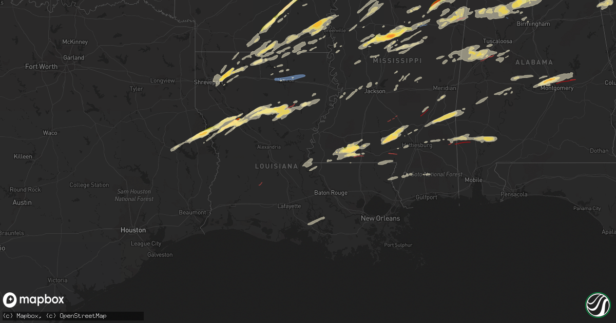
November 29 map
$229
one time, instant access
Download today. No call, no setup
Keep the $229
Bought the map and want the full workflow? Apply the entire $229 to a subscription within 7 days. None of it is wasted.
Every map, not just this one
This buys you this map. Subscription and you get every map we run, in the markets you choose from a few cities to whole states to nationwide. Plus real-time alerts the moment a storm fires.
Contact data
Name, contact info, occupancy, even credit band for addresses in the footprint. You go from where it hit to who to call.
Become the source they trust
Unlimited branding weather history reports on demand. You already have the documented answer ready for the property owner, and you are the one who showed up with it.
Property data and RoofTrace estimates
Pull up any address you have got, its value and the exact code rules for that jurisdiction, straight from One Click Code. Then RoofTrace estimates the squares, pitch, and roof value, priced the way you price.
Storm reports in Louisiana
Louisiana
| Date | Description |
|---|---|
| 11/29/20225:01 PM CST | Report from gas station at the intersection of highway 371 and main street. |
| 11/29/20225:00 PM CST | Roof blown off chicken house. Also... Light pole down along with several trees on middle road northeast of dubberly. |
| 11/29/20224:28 PM CST | A local report indicates 1.75 inch wind near NATCHITOCHES |
| 11/29/20224:20 PM CST | Correction...public reports hail half dollar to golfball size in hagewood community. |
| 11/29/20224:20 PM CST | Public reports hail up to half dollar size in hagewood community. |
| 11/29/20224:11 PM CST | A local report indicates 1.50 inch wind near ROBELINE |
| 11/29/20224:08 PM CST | Roof blown off a home in the holum community. |
| 11/29/20224:00 PM CST | Ksla-tv viewer reports hail ranging from nickel to quarter size near many... La. |
| 11/29/20223:55 PM CST | Social media photo of ping pong size hail east of zwolle along louisiana state hwy 120. |
| 11/29/20223:39 PM CST | Nickel to quarter size hail southwest of zwolle along toledo bend reservoir. |
| 11/29/20225:14 AM CST | At 1114 PM CST, a severe thunderstorm was located near Start, moving east at 55 mph. HAZARD...60 mph wind gusts and quarter size hail. SOURCE...Radar indicated. IMPACT...Hail damage to vehicles is expected. Expect wind damage to roofs, siding, and trees. This severe thunderstorm will be near... Goodwill around 1140 PM CST. Darnell around 1145 PM CST. Transylvania around 1200 AM CST. Lake Providence around 1205 AM CST.Other locations impacted by this severe thunderstorm include Forest,Pioneer, Oak Ridge and Epps. |
| 11/28/202211:57 PM CST | At 557 PM CST, a severe thunderstorm was located 11 miles southwest of Campti, or 12 miles northwest of Natchitoches, moving northeast at 50 mph. HAZARD...60 mph wind gusts and half dollar size hail. SOURCE...Radar indicated. IMPACT...Hail damage to vehicles is expected. Expect wind damage to roofs, siding, and trees. Locations impacted include... Natchitoches, Campti, Allen, Clarence, Powhatan, Black Lake, Grand Ecore, Clear Lake and Creston. |
| 11/28/202211:35 PM CST | At 535 PM CST, a severe thunderstorm was located 7 miles northwest of Olla, or 14 miles southwest of Columbia, moving northeast at 45 mph. HAZARD...60 mph wind gusts and half dollar size hail. SOURCE...Radar indicated. IMPACT...Hail damage to vehicles is expected. Expect wind damage to roofs, siding, and trees. Locations impacted include... Columbia, Olla, Clarks, Grayson, Urania, Sikes, Spaulding, Burlington, Riverton, Standard and Kelly. |
| 11/28/202211:24 PM CST | At 524 PM CST, a severe thunderstorm was located over Newman, or 12 miles southeast of Vicksburg, moving northeast at 45 mph. HAZARD...60 mph wind gusts and quarter size hail. SOURCE...Radar indicated. IMPACT...Hail damage to vehicles is expected. Expect wind damage to roofs, siding, and trees. This severe thunderstorm will be near... Edwards around 535 PM CST. Bolton around 545 PM CST. Clinton and Brownsville around 550 PM CST. Pocahontas around 600 PM CST.Other locations impacted by this severe thunderstorm include Mound,Learned and Delta. |
| 11/28/202211:01 PM CST | At 500 PM CST, a severe thunderstorm was located 7 miles southwest of Winnfield, moving northeast at 45 mph. HAZARD...60 mph wind gusts and half dollar size hail. SOURCE...Radar indicated. IMPACT...Hail damage to vehicles is expected. Expect wind damage to roofs, siding, and trees. Locations impacted include... Winnfield, Calvin, Atlanta, Sikes, Joyce and Hudson. |
| 11/28/202210:58 PM CST | At 458 PM CST, a severe thunderstorm was located over Doyline, or 9 miles southwest of Minden, moving northeast at 55 mph. HAZARD...60 mph wind gusts and half dollar size hail. SOURCE...Radar indicated. IMPACT...Hail damage to vehicles is expected. Expect wind damage to roofs, siding, and trees. Locations impacted include... Minden, Homer, Haughton, Haynesville, Sibley, Doyline, Dubberly, Dixie Inn, Shongaloo, Eastwood, Evergreen, Lisbon, Leton, Curtis, Fillmore, Bodcau, Plum Orchard Landing, Gilark, Noles Landing and Lake Bistineau North. |
| 11/28/202210:53 PM CST | 56 kt |
| 11/28/202210:12 PM CST | At 412 PM CST, a severe thunderstorm was located 11 miles west of Natchitoches, moving northeast at 60 mph. HAZARD...Golf ball size hail and 60 mph wind gusts. SOURCE...Radar indicated. IMPACT...People and animals outdoors will be injured. Expect hail damage to roofs, siding, windows, and vehicles. Expect wind damage to roofs, siding, and trees. Locations impacted include... Natchitoches, Winnfield, Campti, Allen, Provencal, Natchez, Clarence, Goldonna, Calvin, Robeline, Atlanta, Powhatan, Grand Ecore, St. Maurice, Black Lake, Clear Lake, Creston, Hagewood and Bermuda. |
| 11/28/20229:59 PM CST | At 358 PM CST, a severe thunderstorm was located near Rosefield, or 15 miles south of Columbia, moving northeast at 55 mph. HAZARD...60 mph wind gusts and half dollar size hail. SOURCE...Radar indicated. IMPACT...Hail damage to vehicles is expected. Expect wind damage to roofs, siding, and trees. This severe thunderstorm will be near... Rosefield around 405 PM CST. Sherwood around 410 PM CST. Enterprise around 415 PM CST. Jigger around 425 PM CST. Winnsboro and Wisner around 430 PM CST.Other locations impacted by this severe thunderstorm include Gilbertand Sicily Island. |
| 11/28/20229:35 PM CST | At 334 PM CST, a severe thunderstorm was located 7 miles northeast of Winnfield, moving east at 45 mph. HAZARD...60 mph wind gusts and half dollar size hail. SOURCE...Radar indicated. IMPACT...Hail damage to vehicles is expected. Expect wind damage to roofs, siding, and trees. Locations impacted include... Winnfield, Clarks, Grayson, Dodson, Sikes, Joyce, Vixen, Hudson and Kelly. |
| 11/28/20227:32 PM CST | The tornado was confirmed from images and video provided by multiple storm chasers via social media. No damage was found during a nws storm survey. |
| 11/28/20227:32 PM CST | Tornado was spotted nw of mound... La. Pictures sent via twitter. |
| 11/28/20227:18 PM CST | At 118 PM CST, a severe thunderstorm was located over Moreauville, moving northeast at 30 mph. HAZARD...Quarter size hail. SOURCE...Radar indicated. IMPACT...Damage to vehicles is expected. Locations impacted include... Moreauville, Bordelonville, Cottonport, Mansura, Plaucheville, Big Bend, Lake Ophelia National Wildlife Refuge and Hamburg. |
| 11/28/20226:03 PM CST | *** 1 inj *** corrects previous tornado report from 6 se clarks. This ef3 tornado traveled roughly 8 miles on an east northeast track through rural portions of southeas |
| 11/28/20226:03 PM CST | Structural damage reported along la highway 126. Poe radar showed a tds continuing on for some distance northeast of this general location. |
All States Impacted by Hail Map on November 29, 2022
Cities Impacted by Hail Map on November 29, 2022
- Clarkson, KY
- Elizabethtown, KY
- Boston, KY
- Dickson, TN
- McEwen, TN
- Vanleer, TN
- Palmyra, TN
- Erin, TN
- Cumberland City, TN
- Cumberland Furnace, TN
- Campbellsville, KY
- Summersville, KY
- Meridian, MS
- Stonewall, MS
- Enterprise, MS
- Gattman, MS
- Starkville, MS
- Mississippi State, MS
- Millport, AL
- West Point, MS
- Aberdeen, MS
- Caledonia, MS
- Steens, MS
- Vernon, AL
- Sulligent, AL
- Cedarbluff, MS
- Hamilton, MS
- Columbus, MS
- Rossville, TN
- Ridgeland, MS
- Madison, MS
- Warren, AR
- Kingston Springs, TN
- Burns, TN
- Centerville, TN
- Nunnelly, TN
- White Bluff, TN
- Charlotte, TN
- Ashland City, TN
- Bon Aqua, TN
- Lobelville, TN
- Only, TN
- Farmerville, LA
- Hollandale, MS
- Cub Run, KY
- Leitchfield, KY
- Stamping Ground, KY
- Bardstown, KY
- Mount Eden, KY
- Sadieville, KY
- Mammoth Cave, KY
- Bonnieville, KY
- Waddy, KY
- Coxs Creek, KY
- Fairfield, KY
- New Haven, KY
- Sweeden, KY
- Bowling Green, KY
- Shelbyville, KY
- Taylorsville, KY
- Bloomfield, KY
- Munfordville, KY
- Hodgenville, KY
- Upton, KY
- Brownsville, KY
- Frankfort, KY
- Sonora, KY
- Bee Spring, KY
- Hornsby, TN
- Bethel Springs, TN
- Pocahontas, TN
- Selmer, TN
- Middleton, TN
- Hurricane Mills, TN
- Byhalia, MS
- Florence, AL
- Park City, KY
- Rocky Hill, KY
- Oakland, KY
- Smiths Grove, KY
- Nesbit, MS
- Southaven, MS
- Hernando, MS
- Coldwater, MS
- Falmouth, KY
- Georgetown, OH
- Hamersville, OH
- Felicity, OH
- Foster, KY
- Brooksville, KY
- Jackson, TN
- Townley, AL
- Berry, AL
- Hanceville, AL
- Bankston, AL
- Trafford, AL
- Oakman, AL
- Hayden, AL
- Fayette, AL
- Carbon Hill, AL
- Empire, AL
- Locust Fork, AL
- Jasper, AL
- Parrish, AL
- Dora, AL
- Warrior, AL
- Bremen, AL
- Cordova, AL
- Kennedy, AL
- Cullman, AL
- Crane Hill, AL
- Cleveland, AL
- Hamburg, AR
- Bastrop, LA
- Canmer, KY
- Hardyville, KY
- Horse Cave, KY
- Magnolia, KY
- Poplar Grove, AR
- El Dorado, AR
- Junction City, AR
- Ackerman, MS
- Greenwood, MS
- Coila, MS
- Carrollton, MS
- Falkner, MS
- Gravel Switch, KY
- Springfield, KY
- Lebanon, KY
- Harrodsburg, KY
- Nicholasville, KY
- Wilmore, KY
- Perryville, KY
- Mackville, KY
- Versailles, KY
- Saltillo, MS
- Winnsboro, LA
- Delhi, LA
- Scooba, MS
- West, MS
- Grady, AR
- Gould, AR
- Lexa, AR
- Crossett, AR
- Marion, LA
- Huttig, AR
- Morton, MS
- Forest, MS
- Lena, MS
- McCool, MS
- French Camp, MS
- Ethel, MS
- Weir, MS
- Baldwyn, MS
- Dumas, MS
- Booneville, MS
- Stewart, MS
- Saint Francisville, LA
- Angola, LA
- Woodville, MS
- Batchelor, LA
- Lettsworth, LA
- Monterey, LA
- Durant, MS
- Eutaw, AL
- Knoxville, AL
- Fairview, TN
- Lyles, TN
- Big Sandy, TN
- Stewart, TN
- Waverly, TN
- Tennessee Ridge, TN
- Coffeeville, MS
- Oakland, MS
- Water Valley, MS
- Tillatoba, MS
- Arkansas City, AR
- Lillie, LA
- Hermitage, AR
- Strong, AR
- Homer, LA
- Lake Village, AR
- Rohwer, AR
- Summerfield, LA
- Bernice, LA
- Spearsville, LA
- Haynesville, LA
- McGehee, AR
- Greenville, MS
- Dermott, AR
- Benoit, MS
- Monticello, AR
- Montrose, AR
- Chatham, MS
- Oxford, MS
- Pontotoc, MS
- Marietta, MS
- Belmont, MS
- Fulton, MS
- Golden, MS
- Ecru, MS
- Cherokee, AL
- New Site, MS
- Blue Springs, MS
- Muscle Shoals, AL
- Iuka, MS
- New Albany, MS
- Tuscumbia, AL
- Guntown, MS
- Thaxton, MS
- Tupelo, MS
- Etta, MS
- Red Bay, AL
- Tishomingo, MS
- Sheffield, AL
- Russellville, AL
- Dennis, MS
- Leighton, AL
- Myrtle, MS
- Marianna, AR
- Linden, TN
- Moundville, AL
- Greensboro, AL
- Sardis, TN
- Finger, TN
- Reagan, TN
- Enville, TN
- Adamsville, TN
- Kilmichael, MS
- Tibbie, AL
- Uriah, AL
- Fruitdale, AL
- State Line, MS
- Deer Park, AL
- Jackson, AL
- Wagarville, AL
- Gainestown, AL
- Leroy, AL
- Chatom, AL
- Portland, AR
- Parkdale, AR
- Olive Branch, MS
- Banks, AR
- Yazoo City, MS
- Vicksburg, MS
- Carthage, MS
- Hemphill, TX
- Clarksville, TN
- Dumas, AR
- Marvell, AR
- Decatur, MS
- Union, MS
- Conehatta, MS
- Barksdale Afb, LA
- Minden, LA
- Haughton, LA
- Sibley, LA
- Elm Grove, LA
- Doyline, LA
- Athens, LA
- Princeton, LA
- Bossier City, LA
- Jones, AL
- Plantersville, AL
- Marion, AL
- Billingsley, AL
- Selma, AL
- Shuqualak, MS
- De Kalb, MS
- Preston, MS
- Ripley, MS
- Birmingham, AL
- Maben, MS
- Mathiston, MS
- Prairie, MS
- Quinton, AL
- Fosters, AL
- Gordo, AL
- Boligee, AL
- Macon, MS
- Aliceville, AL
- Ralph, AL
- Emelle, AL
- Belzoni, MS
- Tchula, MS
- Prattville, AL
- Downsville, LA
- Southside, TN
- Cunningham, TN
- Olmstead, KY
- Adairville, KY
- Franklin, KY
- Springfield, TN
- Cedar Hill, TN
- Russellville, KY
- Clinton, MS
- Jackson, MS
- Paris, KY
- Lexington, KY
- Lexington, MS
- Cruger, MS
- Vaiden, MS
- Eupora, MS
- Winona, MS
- Sidon, MS
- Pheba, MS
- Silver City, MS
- De Witt, AR
- Ethel, AR
- Gillett, AR
- Holly Grove, AR
- Clarendon, AR
- Saint Charles, AR
- Stuttgart, AR
- Duncanville, AL
- Centreville, AL
- Orrville, AL
- Safford, AL
- Alberta, AL
- Philipp, MS
- Schlater, MS
- Sunflower, MS
- Charleston, MS
- Holcomb, MS
- Cascilla, MS
- Minter City, MS
- Parsons, TN
- Decaturville, TN
- Fruithurst, AL
- Rockmart, GA
- Muscadine, AL
- Tallapoosa, GA
- Cedartown, GA
- Buchanan, GA
- Stanton, TN
- Robinsonville, MS
- West Helena, AR
- Helena, AR
- Germantown, TN
- Eads, TN
- Memphis, TN
- Tunica, MS
- Collierville, TN
- Cordova, TN
- Oakland, TN
- Dundee, MS
- Mason, TN
- Horn Lake, MS
- Lake Cormorant, MS
- Walls, MS
- Somerville, TN
- Arlington, TN
- Monroe, LA
- Sterlington, LA
- Vardaman, MS
- Calhoun City, MS
- Gore Springs, MS
- Walnut Grove, MS
- Guthrie, KY
- Allensville, KY
- Buhl, AL
- Tuscaloosa, AL
- Bay Springs, MS
- Paulding, MS
- Enid, MS
- Utica, MS
- Edwards, MS
- Seminary, MS
- Richton, MS
- Kelly, LA
- Winnfield, LA
- Goldonna, LA
- Natchitoches, LA
- Atlanta, LA
- Sikes, LA
- Dodson, LA
- Olla, LA
- Grayson, LA
- Columbia, LA
- Tullos, LA
- Robeline, LA
- Provencal, LA
- Nettleton, MS
- Hampton, AR
- Harrell, AR
- Gilbert, LA
- Collins, MS
- Columbia, MS
- Sumrall, MS
- Monticello, MS
- Prentiss, MS
- Bassfield, MS
- Oak Vale, MS
- Carson, MS
- Foxworth, MS
- Jayess, MS
- Almyra, AR
- Gibsland, LA
- Dubberly, LA
- Okolona, MS
- Amory, MS
- Liberty, MS
- Summit, MS
- Smithdale, MS
- Magnolia, MS
- Kosciusko, MS
- Baldwin, LA
- Franklin, LA
- Jeanerette, LA
- Morgan City, LA
- Waynesboro, MS
- Shubuta, MS
- Melvin, AL
- Laurel, MS
- Gilbertown, AL
- Sallis, MS
- Marion Junction, AL
- Thomaston, AL
- Catherine, AL
- Mccomb, MS
- Toxey, AL
- Silas, AL
- Quitman, MS
- Needham, AL
- Star City, AR
- New Edinburg, AR
- Rison, AR
- Many, LA
- Belmont, LA
- Zwolle, LA
- Marthaville, LA
- Centreville, MS
- Bogue Chitto, MS
- Gloster, MS
- Ruth, MS
- Heflin, LA
- Huntington, TX
- Goodman, MS
- Louisville, MS
- Ellisville, MS
- Cotton Valley, LA
- Adamsville, AL
- Graysville, AL
- Mantee, MS
- Woodland, MS
- Houston, MS
- Smithville, MS
- Tremont, MS
- Carriere, MS
- Poplarville, MS
- Bogalusa, LA
- West Monroe, LA
- Benton, MS
- Pickens, MS
- Ruleville, MS
- Courtland, MS
- Pope, MS
- Tutwiler, MS
- Drew, MS
- Louann, AR
- Yorktown, AR
- Greensburg, LA
- Brent, AL
- Altheimer, AR
- Itta Bena, MS
- Petal, MS
- Bolton, MS
- Sweet Water, AL
- Linden, AL
- Milam, TX
- Broaddus, TX
- San Augustine, TX
- Noble, LA
- Bronson, TX
- Indianola, MS
- Pelahatchie, MS
- Wisner, LA
- Franklinton, LA
- Sandy Hook, MS
- Angie, LA
- Tylertown, MS
- Glen Allan, MS
- Wetumpka, AL
- Autaugaville, AL
- Coosada, AL
- Deatsville, AL
- Millbrook, AL
- Elmore, AL
- Hattiesburg, MS
- Pleasant Hill, LA
- Fort Necessity, LA
- Zavalla, TX
- Montgomery, LA
- Georgetown, LA
- Campti, LA
- Newellton, LA
- Etoile, TX
- Dubach, LA
- Perkinston, MS
- Booth, AL
- Lowndesboro, AL
- Montgomery, AL
- Eclectic, AL
- Tallassee, AL
- Wilmot, AR
- Hollywood, AL
- Cave City, KY
- Adams, TN
- Scottsboro, AL
- Fackler, AL
- Joelton, TN
- Calhoun, LA
- Oak Ridge, LA
- Collinston, LA
- Rayville, LA
- Killen, AL
- Blue Mountain, MS
- Town Creek, AL
- Athens, AL
- Rogersville, AL
- Oneonta, AL
- Greensburg, KY
- Salvisa, KY
- Lawrenceburg, KY
- Bagdad, KY
- Oberlin, LA
- Heidelberg, MS
- Stringer, MS
- Akron, AL
- Newhebron, MS
- Magee, MS


