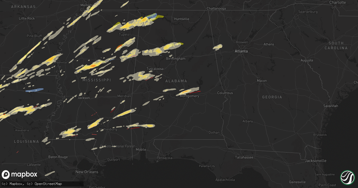
Hail Map in Alabama on November 29, 2022
Get this storm
November 29 map
$229
one time, instant access
Download today. No call, no setup
Keep the $229
Bought the map and want the full workflow? Apply the entire $229 to a subscription within 7 days. None of it is wasted.
Every map, not just this one
This buys you this map. Subscription and you get every map we run, in the markets you choose from a few cities to whole states to nationwide. Plus real-time alerts the moment a storm fires.
Contact data
Name, contact info, occupancy, even credit band for addresses in the footprint. You go from where it hit to who to call.
Become the source they trust
Unlimited branding weather history reports on demand. You already have the documented answer ready for the property owner, and you are the one who showed up with it.
Property data and RoofTrace estimates
Pull up any address you have got, its value and the exact code rules for that jurisdiction, straight from One Click Code. Then RoofTrace estimates the squares, pitch, and roof value, priced the way you price.
Storm reports in Alabama
Alabama
| Date | Description |
|---|---|
| 11/29/20224:10 PM CST | Large trees fell on home and caused damage to walls and roof. Time estimated based on radar. |
| 11/29/20223:50 PM CST | Large trees fell on a home and caused minor roof damage. Time estimated based on radar. |
| 11/29/20223:50 PM CST | Photo of multiple trees snapped passed along from ema. Time estimated based on radar. |
| 11/29/20223:30 PM CST | Powerlines reported down across the area. Time estimated based on radar. |
| 11/29/20221:40 PM CST | A large metal barn at a farm was destroyed. Metal debris was blown across the adjacent road which also knocked down power lines. Time estimated by radar. |
| 11/29/20221:20 PM CST | Reports of half dollar sized hail in the city of petersville. |
| 11/29/202212:48 PM CST | Corrects previous tstm wnd dmg report from 3 s pigeye. A few trees were blown down between bexar and hackleburg in the northwest part of marion county. |
| 11/29/202212:45 PM CST | Em reported ping pong ball sized hail in the city of cherokee. |
| 11/29/20226:35 AM CST | At 1235 PM CST, severe thunderstorms were located along a line extending from near Midway to near Burton, moving east at 55 mph. HAZARD...60 mph wind gusts and quarter size hail. SOURCE...Radar indicated. IMPACT...Hail damage to vehicles is expected. Expect wind damage to roofs, siding, and trees. Locations impacted include... Tuscumbia, Cherokee, Malone, Posey Loop, Pogo, Mt Hester, Srygley Church, New Bethel, Allsboro and Maud. |
| 11/29/20226:29 AM CST | At 1229 PM CST, a severe thunderstorm was located over Burton, or 7 miles west of Tishomingo State Park, moving northeast at 60 mph. HAZARD...60 mph wind gusts and quarter size hail. SOURCE...Radar indicated. IMPACT...Hail damage to vehicles is expected. Expect wind damage to roofs, siding, and trees. Locations impacted include... Iuka, Tishomingo State Park, Tishomingo, Burton, Midway, Marietta, Paden, Oldham, Thrasher, Dennis, Blythe Crossing, Bloody Springs, Carter Branch, Mingo, Holcut, Holts Spur, Petertown, Neil and Altitude. |
| 11/29/20226:09 AM CST | At 1209 PM CST, a severe thunderstorm was located over New Salem, or 9 miles southeast of Fulton, moving northeast at 50 mph. HAZARD...Half dollar size hail. SOURCE...Radar indicated. IMPACT...Damage to vehicles is expected. Locations impacted include... Hamilton, Hackleburg, Weston, Pigeye, Shottsville and Bexar. |
| 11/29/20225:45 AM CST | A brief ef0 tornado touched down in the woods between ten mile road and barefoot road at approximately 5:45 am. As the tornado approached barefoot road... Numerous pine |
| 11/29/20225:42 AM CST | An ef0 caused minor timber damage along country road 6643. |
| 11/29/20225:20 AM CST | Trees down in goshen blocking roadways. Power outages also reported. |
| 11/29/20225:10 AM CST | Emergency manager reports tree down with damaged power lines. |
| 11/29/20225:10 AM CST | Emergency manager reports a tree down... Blocking glenwood road. Powerlines are also damaged. |
| 11/29/20225:10 AM CST | Emergency m |
| 11/29/20225:10 AM CST | Emergency manager reports a tree down... Blocking glenwood road. Powerline |
| 11/29/20225:08 AM CST | Media received pictures of a large tree down on a home. |
| 11/29/20225:00 AM CST | Emergency manager reports multiple trees down... Some blocking roadways. |
| 11/29/20224:56 AM CST | At 1056 PM CST, severe thunderstorms were located along a line extending from near Shannon to near Pala Alto, moving east at 55 mph. HAZARD...60 mph wind gusts. SOURCE...Radar indicated. IMPACT...Expect damage to roofs, siding, and trees. Locations impacted include... Amory, Aberdeen, Okolona, Shannon, Smithville, Prairie, New Wren, Nettleton, Hatley, Gattman, Quincy, Turon, Egypt, Wise Gap, Wren, Strong, McCondy, Muldon, Leotis and Binford. |
| 11/29/20223:38 AM CST | Numerous trees were blown down and were snapped off. Some minor structure damage. The damage path was 6.26 miles long and was 400 yards wide at its widest point. |
| 11/29/20223:30 AM CST | Tds. Structural damage reported along firetower rd. |
| 11/29/20223:25 AM CST | Tds. Numerous homes damaged and trees down near hwy 231 and jasmine hill rd. Damage continues along willow |
| 11/29/20223:25 AM CST | Tds. Numerous homes damaged and trees down near hwy 231 and jasmine hill rd. Damage continues along willow springs rd to redland rd. |
| 11/29/20223:24 AM CST | Tds. Powerlines down on 231 bridge and in tallapoosa river. Roadway impassable. |
| 11/29/20223:22 AM CST | At 922 PM CST, a severe thunderstorm was located over New West Greene, or 14 miles south of Aliceville, moving east at 30 mph. HAZARD...60 mph wind gusts and quarter size hail. SOURCE...Radar indicated. IMPACT...Hail damage to vehicles is expected. Expect wind damage to roofs, siding, and trees. Locations impacted include... Eutaw, Union, Gainesville, New West Greene, Mantua, West Greene, Knoxville, Snoddy, Warsaw, New Mount Hebron, Eutaw Municipal Airport, Clinton, Pleasant Ridge, Lewiston and I 20 Rest Area Near Eutaw. |
| 11/29/20223:19 AM CST | *** 2 fatal *** updates previous tornado report from 2 nne boylston. Tds on radar. Damage to multiple homes and manufactured homes on dunn ln and williams drive. 2 fata |
| 11/29/20223:19 AM CST | Tds on radar. Damage to multiple homes and manufactured homes on dunn ln and williams drive. Injuries reported. |
| 11/29/20223:14 AM CST | *** 2 fatal... 2 inj *** numerous trees were blown down or were snapped off. Damage to multiple homes and manufactured homes. 2 fatalities. At least 2 injuries. The dam |
| 11/29/20223:09 AM CST | Trees and powerlines down along club wiley road. |
| 11/29/20222:53 AM CST | Trees down along abb road. |
| 11/29/20222:48 AM CST | Heavy damage to homes along leo road in tibbie. |
| 11/29/20222:48 AM CST | Houses with major damage along boyd willie parnell road. |
| 11/29/20222:48 AM CST | Trees and powerlines down along toomey pond road. |
| 11/29/20222:47 AM CST | Trees down along highway 17 in tibbie. |
| 11/29/20222:43 AM CST | Damage to homes to homes along sawmill road northwest of tibbie. This may have occurred with a satellite tornado to the north of the primary tornadic circulation. |
| 11/29/20222:38 AM CST | At 838 PM CST, a severe thunderstorm was located over De Kalb, or 11 miles southeast of Preston, moving northeast at 55 mph. HAZARD...60 mph wind gusts and quarter size hail. SOURCE...Radar indicated. IMPACT...Hail damage to vehicles is expected. Expect wind damage to roofs, siding, and trees. This severe thunderstorm will be near... Paulette around 855 PM CST. Cooksville around 900 PM CST.Other locations impacted by this severe thunderstorm includeShuqualak and Scooba. |
| 11/29/20222:34 AM CST | Trees and powerlines down along with structural damage. |
| 11/29/20222:32 AM CST | Debris signature noted on radar. Emergency management preliminarily reports major damage in the fruitdale community. Time estimated from radar. |
| 11/29/20222:15 AM CST | Trees down blocking the roadway at hollis crossroads. Time estimated from radar. |
| 11/29/20221:51 AM CST | Tree down on airport rd near oxford. Power outages reported in anniston. |
| 11/29/20221:37 AM CST | Several pine trees snapped and uprooted on mudd street. Tds identified on radar. Time estimated by radar. |
| 11/29/20221:37 AM CST | Corrects previous tornado report from 6 nnw eastaboga. Nws storm survey found ef-0 tornado damage near mudd st. Several pine trees snapped and uprooted along very brief |
| 11/29/20221:24 AM CST | Multiple trees down at various locations across st. Clair county. |
| 11/29/20221:20 AM CST | Structural damage to home along markeeta spur rd... In moody. |
| 11/29/20221:15 AM CST | Tree damage reported on wayne road just northeast of sweet water... Where a large tree also damaged a house. Additional reports of damage via broadcast media nearby as |
| 11/29/20221:11 AM CST | The tornado began in a wooded area southeast of county road 6 to the southwest of sweet water in southern marengo county. Tree damage was initially minor as it moved no |
| 11/29/20221:10 AM CST | Trees snapped and downed on county road 13 in locust fork. |
| 11/29/20221:08 AM CST | Multiple trees down in trussville. |
| 11/29/20221:06 AM CST | Trees and powerlines down in ensley... Including one on a home on avenue q. |
| 11/29/20221:05 AM CST | Trees down just off tabernacle road. |
| 11/29/20221:05 AM CST | Multiple trees down in northeast birmingham... Including one on a home on roebuck circle. |
| 11/29/20221:04 AM CST | Corrects previous tstm wnd dmg report from 2 wnw locust fork. Powerlines and trees snapped on deaver walker road west of locust fork. Also... Large trees downed on a ba |
| 11/29/20221:04 AM CST | Multiple trees down in center point. |
| 11/29/20221:02 AM CST | Multiple trees down in palmerdale. |
| 11/29/20221:00 AM CST | Structural damage at tim king rd and deavers town rd... South of cleveland. |
| 11/29/202212:59 AM CST | Multiple trees down in locust fork. |
| 11/29/202212:59 AM CST | Structural damage on jerry marsh rd... Southwest of cleveland. |
| 11/29/202212:58 AM CST | An ef0 tornado downed trees... A couple of which damaged structures... And caused minor roof damage. |
| 11/29/202212:57 AM CST | Photo via social media. |
| 11/29/202212:55 AM CST | Multiple trees and power lines down in mount olive. |
| 11/29/202212:55 AM CST | Large tree down on mudcreek rd and harmon rd in oak grove. |
| 11/29/202212:52 AM CST | At 649 PM CST, a severe thunderstorm was located near Oakman, or 8 miles southeast of Carbon Hill, moving east at 40 mph. HAZARD...60 mph wind gusts and quarter size hail. SOURCE...Radar indicated. IMPACT...Hail damage to vehicles is expected. Expect wind damage to roofs, siding, and trees. Locations impacted include... Jasper, Sumiton, Cordova, Dora, Carbon Hill, Parrish, Oakman, Sipsey, Kansas, Curry, Smith Dam, Rocky Hollow, Beloit, Lynns Park, Smith Lake, Empire, West Corona, Cedrum Area, Holly Grove and Powellville. |
| 11/29/202212:51 AM CST | Multiple trees down in hayden. |
| 11/29/202212:50 AM CST | Multiple trees down in graysville and brookside... Including along highway 78. |
| 11/29/202212:44 AM CST | Trees and powerlines down in west jefferson. |
| 11/29/202212:42 AM CST | Trees and powerlines down in the bagley area. |
| 11/29/202212:35 AM CST | A tree was reported down at 8304 highway 91 which knocked down powerlines. |
| 11/29/202212:33 AM CST | A tree was reported down near the intersection of highway 91 and cr 27. |
| 11/29/202212:28 AM CST | Minor timber damage was caused by a tornado. The damage path was 1.99 miles long and 50 yards wide at its widest point. |
| 11/29/202212:26 AM CST | Thunderstorm winds snapped large tree branches at this location. A power flash was observed about 2 miles north of this location... Followed by intermittent power outag |
| 11/29/202212:20 AM CST | Trees and power lines down in numerous locations around the county including boldo... Sipsey... And piney woods. |
| 11/29/202212:12 AM CST | At 612 PM CST, a severe thunderstorm was located over Waverly, or over Columbus AFB, moving east at 45 mph. HAZARD...Half dollar size hail. SOURCE...Radar indicated. IMPACT...Damage to vehicles is expected. Locations impacted include... Vernon, Millport, Kennedy, Blooming Grove, Bedford, Crossville, Cody, Star, Hightogy, Lamar County Public Lake and Melborne. |
| 11/29/202212:09 AM CST | At 609 PM CST, a severe thunderstorm was located near Fayette, moving northeast at 40 mph. HAZARD...Half dollar size hail. SOURCE...Radar indicated. IMPACT...Damage to vehicles is expected. Locations impacted include... Winfield, Fayette, Carbon Hill, Glen Allen, Kansas, Belk, Eldridge, Bluff, Bazemore, Richard Arthur Field, Bevill State College Fayette, Hubbertville, Cedrum Area, Fowlers Crossroads, Holly Grove and Townley. |
| 11/28/202211:46 PM CST | Several trees were blown down across marion county. |
| 11/28/202211:41 PM CST | Multiple trees down reported at the intersection of cr 150 and red bank road and the intersection of cr 406 and cr 270. |
| 11/28/202211:30 PM CST | A tree was blown down at the intersection of jackson highway and oak street. Time estimated based on radar. |
| 11/28/202211:21 PM CST | A tree was reported down at the intersection of underwood mountain road and county farm road. |
| 11/28/202211:20 PM CST | A tree was blown down at the intersection of underwood mountain road and new cut road. Time estimated based on radar. |
| 11/28/202211:20 PM CST | At 520 PM EST, a severe thunderstorm was located over Rising Fawn, or 7 miles south of Trenton, moving east at 45 mph. HAZARD...60 mph wind gusts and penny size hail. SOURCE...Radar indicated. IMPACT...Expect damage to roofs, siding, and trees. Locations impacted include... Lafayette, Trenton, Fort Oglethorpe, Chickamauga, La Fayette, Chattanooga Valley, Rising Fawn, Noble, Linwood, New England, Cloudland Canyon State Park, Cooper Heights, Rock Spring and Fairview. |
| 11/28/202211:15 PM CST | A tree was reported down off of greenhill road in colbert county... Al. |
| 11/28/202211:15 PM CST | A tree was knocked down at old lee highway and mulberry road in barton. Time estimated by radar. |
| 11/28/202210:01 PM CST | Numerous trees down and damage to residences in the akron area. Tds seen on radar. |
| 11/28/20229:44 PM CST | Damage reported at the sagewood apartments near eutaw. |
| 11/28/20229:44 PM CST | Corrects previous tornado report from 1 ese eutaw rest area. Damage reported at the sagewood apartments near eutaw. At least 30 homes damaged in hale county. Tds seen o |
| 11/28/20229:44 PM CST | Corrects previous tstm wnd dmg report from 1 ese eutaw rest area to tornado. Damage reported at the sagewood apartments near eutaw. Tds seen on radar. |
| 11/28/20228:46 PM CST | At 245 PM CST, severe thunderstorms were located along a line extending from Moores Mill to Marshall Space Flight Center to 6 miles west of Hartselle, moving east at 45 mph. Spotter at the HSV intermodel center measured gusts of 55 mph. HAZARD...60 mph wind gusts. SOURCE...Trained weather spotters. IMPACT...Expect damage to roofs, siding, and trees. Locations impacted include... Huntsville, Decatur, Madison, Hartselle, Moores Mill, Redstone Arsenal, Meridianville, Priceville, Owens Cross Roads and Gurley. |
| 11/28/20228:28 PM CST | At 228 PM CST, a severe thunderstorm was located over Chatom, moving northeast at 25 mph. HAZARD...60 mph wind gusts and quarter size hail. SOURCE...Radar indicated. IMPACT...Hail damage to vehicles is expected. Expect wind damage to roofs, siding, and trees. Locations impacted include... Chatom and Saint Stephens. |
| 11/28/20228:16 PM CST | At 215 PM CST, a severe thunderstorm was located near Leighton, or 8 miles southeast of Muscle Shoals, moving east at 55 mph. HAZARD...60 mph wind gusts and half dollar size hail. SOURCE...Radar indicated. IMPACT...Hail damage to vehicles is expected. Expect wind damage to roofs, siding, and trees. Locations impacted include... Decatur, Athens, Rogersville, Town Creek, Leighton, Courtland, Tanner, North Courtland, Hillsboro and Cartwright. |
| 11/28/20227:56 PM CST | At 156 PM CST, a severe thunderstorm was located 7 miles north of Belgreen, or 8 miles northwest of Russellville, moving east at 45 mph. HAZARD...60 mph wind gusts and half dollar size hail. SOURCE...Radar indicated. IMPACT...Hail damage to vehicles is expected. Expect wind damage to roofs, siding, and trees. Locations impacted include... Muscle Shoals, Russellville, Sheffield, Tuscumbia, Littleville, Leighton, Posey Loop, Northwest Alabama Regional Airport, Cedar Creek Reservoir and Srygley Church. |
| 11/28/20227:27 PM CST | At 126 PM CST, a severe thunderstorm was located over St. Florian, or near Florence, moving northeast at 40 mph. HAZARD...60 mph wind gusts and half dollar size hail. SOURCE...Trained weather spotters. IMPACT...Hail damage to vehicles is expected. Expect wind damage to roofs, siding, and trees. Locations impacted include... Florence, Muscle Shoals, Killen, Lexington, St. Florian, Underwood-Petersville, Green Hill, Center Star, Kingtown and Whitehead. |
| 11/28/20227:20 PM CST | Roof damage on storage buildings on main street. Left side of one building was damaged. |
| 11/28/20227:00 PM CST | At 1259 PM CST, a severe thunderstorm was located near Cherokee, or 12 miles west of Tuscumbia, moving northeast at 30 mph. HAZARD...Ping pong ball size hail. SOURCE...Emergency management. IMPACT...People and animals outdoors will be injured. Expect damage to roofs, siding, windows, and vehicles. Locations impacted include... Florence, Muscle Shoals, Sheffield, Tuscumbia, Cherokee, St. Florian, Underwood-Petersville, Posey Loop, Northwest Alabama Regional Airport and Mt Hester. |
| 11/28/20226:30 PM CST | Trees were blown down along cr 121. |
All States Impacted by Hail Map on November 29, 2022
Cities Impacted by Hail Map on November 29, 2022
- Clarkson, KY
- Elizabethtown, KY
- Boston, KY
- Dickson, TN
- McEwen, TN
- Vanleer, TN
- Palmyra, TN
- Erin, TN
- Cumberland City, TN
- Cumberland Furnace, TN
- Campbellsville, KY
- Summersville, KY
- Meridian, MS
- Stonewall, MS
- Enterprise, MS
- Gattman, MS
- Starkville, MS
- Mississippi State, MS
- Millport, AL
- West Point, MS
- Aberdeen, MS
- Caledonia, MS
- Steens, MS
- Vernon, AL
- Sulligent, AL
- Cedarbluff, MS
- Hamilton, MS
- Columbus, MS
- Rossville, TN
- Ridgeland, MS
- Madison, MS
- Warren, AR
- Kingston Springs, TN
- Burns, TN
- Centerville, TN
- Nunnelly, TN
- White Bluff, TN
- Charlotte, TN
- Ashland City, TN
- Bon Aqua, TN
- Lobelville, TN
- Only, TN
- Farmerville, LA
- Hollandale, MS
- Cub Run, KY
- Leitchfield, KY
- Stamping Ground, KY
- Bardstown, KY
- Mount Eden, KY
- Sadieville, KY
- Mammoth Cave, KY
- Bonnieville, KY
- Waddy, KY
- Coxs Creek, KY
- Fairfield, KY
- New Haven, KY
- Sweeden, KY
- Bowling Green, KY
- Shelbyville, KY
- Taylorsville, KY
- Bloomfield, KY
- Munfordville, KY
- Hodgenville, KY
- Upton, KY
- Brownsville, KY
- Frankfort, KY
- Sonora, KY
- Bee Spring, KY
- Hornsby, TN
- Bethel Springs, TN
- Pocahontas, TN
- Selmer, TN
- Middleton, TN
- Hurricane Mills, TN
- Byhalia, MS
- Florence, AL
- Park City, KY
- Rocky Hill, KY
- Oakland, KY
- Smiths Grove, KY
- Nesbit, MS
- Southaven, MS
- Hernando, MS
- Coldwater, MS
- Falmouth, KY
- Georgetown, OH
- Hamersville, OH
- Felicity, OH
- Foster, KY
- Brooksville, KY
- Jackson, TN
- Townley, AL
- Berry, AL
- Hanceville, AL
- Bankston, AL
- Trafford, AL
- Oakman, AL
- Hayden, AL
- Fayette, AL
- Carbon Hill, AL
- Empire, AL
- Locust Fork, AL
- Jasper, AL
- Parrish, AL
- Dora, AL
- Warrior, AL
- Bremen, AL
- Cordova, AL
- Kennedy, AL
- Cullman, AL
- Crane Hill, AL
- Cleveland, AL
- Hamburg, AR
- Bastrop, LA
- Canmer, KY
- Hardyville, KY
- Horse Cave, KY
- Magnolia, KY
- Poplar Grove, AR
- El Dorado, AR
- Junction City, AR
- Ackerman, MS
- Greenwood, MS
- Coila, MS
- Carrollton, MS
- Falkner, MS
- Gravel Switch, KY
- Springfield, KY
- Lebanon, KY
- Harrodsburg, KY
- Nicholasville, KY
- Wilmore, KY
- Perryville, KY
- Mackville, KY
- Versailles, KY
- Saltillo, MS
- Winnsboro, LA
- Delhi, LA
- Scooba, MS
- West, MS
- Grady, AR
- Gould, AR
- Lexa, AR
- Crossett, AR
- Marion, LA
- Huttig, AR
- Morton, MS
- Forest, MS
- Lena, MS
- McCool, MS
- French Camp, MS
- Ethel, MS
- Weir, MS
- Baldwyn, MS
- Dumas, MS
- Booneville, MS
- Stewart, MS
- Saint Francisville, LA
- Angola, LA
- Woodville, MS
- Batchelor, LA
- Lettsworth, LA
- Monterey, LA
- Durant, MS
- Eutaw, AL
- Knoxville, AL
- Fairview, TN
- Lyles, TN
- Big Sandy, TN
- Stewart, TN
- Waverly, TN
- Tennessee Ridge, TN
- Coffeeville, MS
- Oakland, MS
- Water Valley, MS
- Tillatoba, MS
- Arkansas City, AR
- Lillie, LA
- Hermitage, AR
- Strong, AR
- Homer, LA
- Lake Village, AR
- Rohwer, AR
- Summerfield, LA
- Bernice, LA
- Spearsville, LA
- Haynesville, LA
- McGehee, AR
- Greenville, MS
- Dermott, AR
- Benoit, MS
- Monticello, AR
- Montrose, AR
- Chatham, MS
- Oxford, MS
- Pontotoc, MS
- Marietta, MS
- Belmont, MS
- Fulton, MS
- Golden, MS
- Ecru, MS
- Cherokee, AL
- New Site, MS
- Blue Springs, MS
- Muscle Shoals, AL
- Iuka, MS
- New Albany, MS
- Tuscumbia, AL
- Guntown, MS
- Thaxton, MS
- Tupelo, MS
- Etta, MS
- Red Bay, AL
- Tishomingo, MS
- Sheffield, AL
- Russellville, AL
- Dennis, MS
- Leighton, AL
- Myrtle, MS
- Marianna, AR
- Linden, TN
- Moundville, AL
- Greensboro, AL
- Sardis, TN
- Finger, TN
- Reagan, TN
- Enville, TN
- Adamsville, TN
- Kilmichael, MS
- Tibbie, AL
- Uriah, AL
- Fruitdale, AL
- State Line, MS
- Deer Park, AL
- Jackson, AL
- Wagarville, AL
- Gainestown, AL
- Leroy, AL
- Chatom, AL
- Portland, AR
- Parkdale, AR
- Olive Branch, MS
- Banks, AR
- Yazoo City, MS
- Vicksburg, MS
- Carthage, MS
- Hemphill, TX
- Clarksville, TN
- Dumas, AR
- Marvell, AR
- Decatur, MS
- Union, MS
- Conehatta, MS
- Barksdale Afb, LA
- Minden, LA
- Haughton, LA
- Sibley, LA
- Elm Grove, LA
- Doyline, LA
- Athens, LA
- Princeton, LA
- Bossier City, LA
- Jones, AL
- Plantersville, AL
- Marion, AL
- Billingsley, AL
- Selma, AL
- Shuqualak, MS
- De Kalb, MS
- Preston, MS
- Ripley, MS
- Birmingham, AL
- Maben, MS
- Mathiston, MS
- Prairie, MS
- Quinton, AL
- Fosters, AL
- Gordo, AL
- Boligee, AL
- Macon, MS
- Aliceville, AL
- Ralph, AL
- Emelle, AL
- Belzoni, MS
- Tchula, MS
- Prattville, AL
- Downsville, LA
- Southside, TN
- Cunningham, TN
- Olmstead, KY
- Adairville, KY
- Franklin, KY
- Springfield, TN
- Cedar Hill, TN
- Russellville, KY
- Clinton, MS
- Jackson, MS
- Paris, KY
- Lexington, KY
- Lexington, MS
- Cruger, MS
- Vaiden, MS
- Eupora, MS
- Winona, MS
- Sidon, MS
- Pheba, MS
- Silver City, MS
- De Witt, AR
- Ethel, AR
- Gillett, AR
- Holly Grove, AR
- Clarendon, AR
- Saint Charles, AR
- Stuttgart, AR
- Duncanville, AL
- Centreville, AL
- Orrville, AL
- Safford, AL
- Alberta, AL
- Philipp, MS
- Schlater, MS
- Sunflower, MS
- Charleston, MS
- Holcomb, MS
- Cascilla, MS
- Minter City, MS
- Parsons, TN
- Decaturville, TN
- Fruithurst, AL
- Rockmart, GA
- Muscadine, AL
- Tallapoosa, GA
- Cedartown, GA
- Buchanan, GA
- Stanton, TN
- Robinsonville, MS
- West Helena, AR
- Helena, AR
- Germantown, TN
- Eads, TN
- Memphis, TN
- Tunica, MS
- Collierville, TN
- Cordova, TN
- Oakland, TN
- Dundee, MS
- Mason, TN
- Horn Lake, MS
- Lake Cormorant, MS
- Walls, MS
- Somerville, TN
- Arlington, TN
- Monroe, LA
- Sterlington, LA
- Vardaman, MS
- Calhoun City, MS
- Gore Springs, MS
- Walnut Grove, MS
- Guthrie, KY
- Allensville, KY
- Buhl, AL
- Tuscaloosa, AL
- Bay Springs, MS
- Paulding, MS
- Enid, MS
- Utica, MS
- Edwards, MS
- Seminary, MS
- Richton, MS
- Kelly, LA
- Winnfield, LA
- Goldonna, LA
- Natchitoches, LA
- Atlanta, LA
- Sikes, LA
- Dodson, LA
- Olla, LA
- Grayson, LA
- Columbia, LA
- Tullos, LA
- Robeline, LA
- Provencal, LA
- Nettleton, MS
- Hampton, AR
- Harrell, AR
- Gilbert, LA
- Collins, MS
- Columbia, MS
- Sumrall, MS
- Monticello, MS
- Prentiss, MS
- Bassfield, MS
- Oak Vale, MS
- Carson, MS
- Foxworth, MS
- Jayess, MS
- Almyra, AR
- Gibsland, LA
- Dubberly, LA
- Okolona, MS
- Amory, MS
- Liberty, MS
- Summit, MS
- Smithdale, MS
- Magnolia, MS
- Kosciusko, MS
- Baldwin, LA
- Franklin, LA
- Jeanerette, LA
- Morgan City, LA
- Waynesboro, MS
- Shubuta, MS
- Melvin, AL
- Laurel, MS
- Gilbertown, AL
- Sallis, MS
- Marion Junction, AL
- Thomaston, AL
- Catherine, AL
- Mccomb, MS
- Toxey, AL
- Silas, AL
- Quitman, MS
- Needham, AL
- Star City, AR
- New Edinburg, AR
- Rison, AR
- Many, LA
- Belmont, LA
- Zwolle, LA
- Marthaville, LA
- Centreville, MS
- Bogue Chitto, MS
- Gloster, MS
- Ruth, MS
- Heflin, LA
- Huntington, TX
- Goodman, MS
- Louisville, MS
- Ellisville, MS
- Cotton Valley, LA
- Adamsville, AL
- Graysville, AL
- Mantee, MS
- Woodland, MS
- Houston, MS
- Smithville, MS
- Tremont, MS
- Carriere, MS
- Poplarville, MS
- Bogalusa, LA
- West Monroe, LA
- Benton, MS
- Pickens, MS
- Ruleville, MS
- Courtland, MS
- Pope, MS
- Tutwiler, MS
- Drew, MS
- Louann, AR
- Yorktown, AR
- Greensburg, LA
- Brent, AL
- Altheimer, AR
- Itta Bena, MS
- Petal, MS
- Bolton, MS
- Sweet Water, AL
- Linden, AL
- Milam, TX
- Broaddus, TX
- San Augustine, TX
- Noble, LA
- Bronson, TX
- Indianola, MS
- Pelahatchie, MS
- Wisner, LA
- Franklinton, LA
- Sandy Hook, MS
- Angie, LA
- Tylertown, MS
- Glen Allan, MS
- Wetumpka, AL
- Autaugaville, AL
- Coosada, AL
- Deatsville, AL
- Millbrook, AL
- Elmore, AL
- Hattiesburg, MS
- Pleasant Hill, LA
- Fort Necessity, LA
- Zavalla, TX
- Montgomery, LA
- Georgetown, LA
- Campti, LA
- Newellton, LA
- Etoile, TX
- Dubach, LA
- Perkinston, MS
- Booth, AL
- Lowndesboro, AL
- Montgomery, AL
- Eclectic, AL
- Tallassee, AL
- Wilmot, AR
- Hollywood, AL
- Cave City, KY
- Adams, TN
- Scottsboro, AL
- Fackler, AL
- Joelton, TN
- Calhoun, LA
- Oak Ridge, LA
- Collinston, LA
- Rayville, LA
- Killen, AL
- Blue Mountain, MS
- Town Creek, AL
- Athens, AL
- Rogersville, AL
- Oneonta, AL
- Greensburg, KY
- Salvisa, KY
- Lawrenceburg, KY
- Bagdad, KY
- Oberlin, LA
- Heidelberg, MS
- Stringer, MS
- Akron, AL
- Newhebron, MS
- Magee, MS


