Hail Map in Kansas City, MO on October 13, 2026
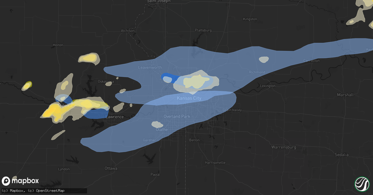
Get this storm
October 13 map
$229
one time, instant access
Download today. No call, no setup
Keep the $229
Bought the map and want the full workflow? Apply the entire $229 to a subscription within 7 days. None of it is wasted.
Every map, not just this one
This buys you this map. Subscription and you get every map we run, in the markets you choose from a few cities to whole states to nationwide. Plus real-time alerts the moment a storm fires.
Contact data
Name, contact info, occupancy, even credit band for addresses in the footprint. You go from where it hit to who to call.
Become the source they trust
Unlimited branding weather history reports on demand. You already have the documented answer ready for the property owner, and you are the one who showed up with it.
Property data and RoofTrace estimates
Pull up any address you have got, its value and the exact code rules for that jurisdiction, straight from One Click Code. Then RoofTrace estimates the squares, pitch, and roof value, priced the way you price.
Storm reports in Kansas City, MO
Kansas City, MO
| Date | Description |
|---|---|
| 10/12/20269:37 PM CDT | Downed wires near the paseo. Time estimated from radar. |
| 10/12/20269:34 PM CDT | Social media and mping reports of tree limbs down in raytown. Time estimated from radar. |
| 10/12/20269:22 PM CDT | Downed wires near 80th and main. Time estimated from radar. |
| 10/12/20267:38 PM CDT | Social media report of a tree down causing minor damage to a residence near 61st street. Time estimated from radar. |
| 10/12/20267:36 PM CDT | Downed tree limbs and wires near whittier street. Time estimated from radar. |
| 10/12/20267:36 PM CDT | Downed tree limbs and wires near eugene field road. Time estimated from radar. |
| 10/12/20267:36 PM CDT | Downed wires near lawndale avenue. Time estimated from radar. |
| 10/12/20267:36 PM CDT | Several social media reports of trees and limbs down near 74th terrace. Time estimated from radar. |
| 10/12/20267:35 PM CDT | Several reports of trees and wires down near gladstone. Time estimated from radar. |
| 10/12/20267:34 PM CDT | Multiple mping reports of trees and limbs down northeast of gladstone. Time estimated from radar. |
| 10/12/20267:33 PM CDT | Downed wires near tullis avenue. Time estimated from radar. |
| 10/12/20267:32 PM CDT | Large tree down on house and vehicle. Time estimated from radar. |
| 10/12/20267:32 PM CDT | Tree down on home. |
| 10/12/20267:32 PM CDT | Social media report of a large tree limb downed near parvin road and davidson road. Time estimated from radar. |
| 10/12/20267:32 PM CDT | Several social media photos of downed trees and limbs near i-35 and chouteau. Time estimated from radar. |
| 10/12/20267:30 PM CDT | Numerous trees down... Electrical power knocked out. |
| 10/12/20267:30 PM CDT | Numerous reports and social media photos of large trees down near 68th and u.s. 169. Several instances of property damage from the fallen trees. Time estimated from rad |
| 10/12/20267:30 PM CDT | Social media reports of a large tree downed in the winnwood area. Time estimated from radar. |
| 10/12/20267:30 PM CDT | Social media report of several tree limbs down near bell street. Time estimated from radar. |
| 10/12/20267:30 PM CDT | Trees snapped and power poles downed. |
| 10/12/20267:30 PM CDT | Multiple trees and limbs down on houses and cars near 67th street. Time estimated from radar. |
| 10/12/20267:30 PM CDT | Several social media reports of trees and wires down near old pike road. Time estimated from radar. |
| 10/12/20267:29 PM CDT | Mping reports of tree limbs down in avondale. Time estimated from radar. |
| 10/12/20267:29 PM CDT | Tree limbs and wires down near 55th street. Time estimated from radar. |
| 10/12/20267:27 PM CDT | Trees and power lines down near 72nd and prairie view. Time estimated from radar. |
| 10/12/20267:26 PM CDT | Social media reports. Of trees down near 76th and troost. Time estimated from radar. |
| 10/12/20267:26 PM CDT | Social media report of a large tree down near line creek elementary. Time estimated from radar. |
| 10/12/20267:25 PM CDT | Several social media reports of trees down in houston lake. Time estimated from radar. |
| 10/12/20267:25 PM CDT | Social media reports of tree limbs down in the briarcliff area. Time estimated from radar. |
| 10/12/20267:24 PM CDT | Large tree downed just east of i-29 in the lake waukomis area. Time estimated from radar. |
| 10/12/20267:23 PM CDT | Social media reports of tree limbs down near green hills road. Time estimated from radar. |
| 10/12/20267:23 PM CDT | Tree limbs and wires down near pleasant view drive. Time estimated from radar. |
| 10/12/20267:22 PM CDT | Private weather sensor. |
| 10/12/20267:20 PM CDT | Downed tree limbs and wires near redhaw lane. Time estimated from radar. |
| 10/12/20267:20 PM CDT | Downed tree limbs and wires near crooked lane. Time estimated from radar. |
| 10/12/20267:20 PM CDT | Numerous trees down. |
| 10/12/20267:20 PM CDT | Several social media reports of trees and wires down in parkville. One resident had a window broken at his house from a downed tree. Time estimated from radar. |
| 10/12/20267:20 PM CDT | Multiple social media reports of trees and limbs down near weatherby lake. Time estimated from radar. |
| 10/12/20267:19 PM CDT | Social media report of a large tree down near route 45 and national drive. Time estimated from radar. |
| 10/12/20267:12 PM CDT | Downed wires near jones-myer road. Time confirmed from radar. |
All States Impacted by Hail Map on October 13, 2026
All Cities Impacted by Hail Map on October 13, 2026
- Perryton, TX
- Balko, OK
- Pawnee Rock, KS
- Moundridge, KS
- Galva, KS
- Canton, KS
- Alva, OK
- Inman, KS
- Buhler, KS
- Coldwater, KS
- Freedom, OK
- Lakeview, TX
- Memphis, TX
- Hedley, TX
- Mullinville, KS
- Hillsboro, KS
- Turon, KS
- Lake City, KS
- Hesston, KS
- Higgins, TX
- Hardtner, KS
- Crosbyton, TX
- Stafford, KS
- Ashland, KS
- Lelia Lake, TX
- Protection, KS
- Quail, TX
- Haviland, KS
- Matador, TX
- Wilmore, KS
- Arnett, OK
- Shattuck, OK
- Minneola, KS
- Post, TX
- Topeka, KS
- Medicine Lodge, KS
- Wellington, TX
- Lorenzo, TX
- Hazleton, IA
- Stanley, IA
- Aurora, IA
- Fairbank, IA
- Oelwein, IA
- Gage, OK
- Marion, KS
- Sylvia, KS
- Lipscomb, TX
- Valley Falls, KS
- Denison, KS
- Fargo, OK
- Rossville, KS
- Saint Marys, KS
- Abbyville, KS
- Mcadoo, TX
- Floydada, TX
- Follett, TX
- Auburn, KS
- Lamont, IA
- Ralls, TX
- Canadian, TX
- Wakarusa, KS
- Mclean, TX
- Balmorhea, TX
- Arlington, KS
- Kiowa, KS
- Hazelton, KS
- Edgewood, IA
- Garber, IA
- Elkport, IA
- Shamrock, TX
- Woodward, OK
- Greeley, IA
- Dundee, IA
- Manchester, IA
- Strawberry Point, IA
- Partridge, KS
- Lincolnville, KS
- Laverne, OK
- May, OK
- Hoyt, KS
- Meriden, KS
- Tecumseh, KS
- Fort Supply, OK
- Childress, TX
- Mcpherson, KS
- Sharon, KS
- Roaring Springs, TX
- Buffalo, OK
- Carbondale, KS
- Scranton, KS
- Colesburg, IA
- Lecompton, KS
- Grantville, KS
- Berryton, KS
- Perry, KS
- Elmdale, KS
- Strong City, KS
- Wheeler, TX
- Dickens, TX
- Cee Vee, TX
- Paducah, TX
- Coats, KS
- Nortonville, KS
- Flomot, TX
- Guttenberg, IA
- Waldron, KS
- Cassville, WI
- North Buena Vista, IA
- Holy Cross, IA
- Potosi, WI
- Attica, KS
- New Vienna, IA
- Quitaque, TX
- Tell, TX
- Lawrence, KS
- McLouth, KS
- Tonganoxie, KS
- Winchester, KS
- Oskaloosa, KS
- Sherrill, IA
- Briscoe, TX
- Anthony, KS
- Harper, KS
- Haven, KS
- Afton, TX
- Murdock, KS
- Turkey, TX
- Easton, KS
- Hollis, OK
- Erick, OK
- Lyons, KS
- Sterling, KS
- Alden, KS
- Leavenworth, KS
- Basehor, KS
- Lansing, KS
- Lockney, TX
- Garden Plain, KS
- Isabel, KS
- Mount Hope, KS
- Burrton, KS
- Cheney, KS
- Cottonwood Falls, KS
- Cedar Point, KS
- Spur, TX
- Rosston, OK
- Pecos, TX
- Council Grove, KS
- Monahans, TX
- Bonner Springs, KS
- Waldron, MO
- Kansas City, MO
- Shawnee, KS
- Kansas City, KS
- Sedgwick, KS
- Newton, KS
- Miami, TX
- Valley Center, KS
- Zenda, KS
- Nashville, KS
- Halstead, KS
- Barstow, TX
- Andale, KS
- Goddard, KS
- Colwich, KS
- Admire, KS
- Emporia, KS
- Willow, OK
- Sayre, OK
- Riverside, MO
- Spivey, KS
- Jamesport, MO
- Coyanosa, TX
- Independence, MO
- Liberty, MO
- Fort Leavenworth, KS
- Platte City, MO
- Camden Point, MO
- Farley, MO
- Weston, MO
- Edgerton, MO
- Smithville, MO
- Trimble, MO
- Kearney, MO
- Holt, MO
- Clearwater, KS
- Viola, KS
- Wichita, KS
- Norwich, KS
- Kingman, KS
- Quanah, TX
- Grandfalls, TX
- Gratiot, WI
- Darlington, WI
- Olpe, KS
- Vinson, OK
- Mangum, OK
- Crowell, TX
- Derby, KS
- Haysville, KS
- Mulvane, KS
- Milton, KS
- Argonia, KS
- Danville, KS
- Sumner, MO
- Mendon, MO
- Brookfield, MO
- Chula, MO
- Laredo, MO
- Monroe, WI
- South Wayne, WI
- Browntown, WI
- Douglass, KS
- Udall, KS
- Rose Hill, KS
- Conway Springs, KS
- Excelsior Springs, MO
- Lawson, MO
- Missouri City, MO
- Sibley, MO
- Orrick, MO
- Buckner, MO
- Gould, OK
- Eldorado, OK
- Duke, OK
- Rothville, MO
- Crane, TX
- Booker, TX
- Bucklin, MO
- Marceline, MO
- Juda, WI
- Monticello, WI
- Richmond, MO
- Camden, MO
- Rayville, MO
- Hardin, MO
- Polo, MO
- Odessa, TX
- Braymer, MO
- Norborne, MO
- Cowgill, MO
- Baldwin City, KS
- Ottawa, KS
- Overbrook, KS
- Green City, MO
- Milan, MO
- Wellsville, KS
- Eudora, KS
- Novinger, MO
- Green Castle, MO
- Kirksville, MO
- Olustee, OK
- Elmer, OK
- Altus, OK
- Granite, OK
- Lone Wolf, OK
- Blair, OK
- Carter, OK
- Bogard, MO
- Carrollton, MO
- Laclede, MO
- La Plata, MO
- Melvern, KS
- Salisbury, MO
- Edgerton, KS
- Linwood, KS
- Olathe, KS
- New Century, KS
- De Soto, KS
- Gardner, KS
- De Witt, MO
- Bosworth, MO
- Lenexa, KS
- Ethel, MO
- New Cambria, MO
- Keytesville, MO
- Mission, KS
- Leawood, KS
- Overland Park, KS
- Roosevelt, OK
- Gotebo, OK
- Rocky, OK
- Sentinel, OK
- Hobart, OK
- Dill City, OK
- Cordell, OK
- Salem, IA
- Hillsboro, IA
- Prairie Village, KS
- Lees Summit, MO
- Donnellson, IA
- West Point, IA
- Dodson, TX
- Callao, MO
- Saint Paul, IA
- Saint Patrick, MO
- Alexandria, MO
- Corn, OK
- Hinton, OK
- Carnegie, OK
- Colony, OK
- Hydro, OK
- Apache, OK
- Mountain View, OK
- Lookeba, OK
- Binger, OK
- Fort Cobb, OK
- Anadarko, OK
- Gracemont, OK
- Blue Springs, MO
- Grain Valley, MO
- Oak Grove, MO
- Brunswick, MO
- Triplett, MO
- Dalton, MO
- Wellington, KS
- Peck, KS
- Fort Madison, IA
- Farmington, IA
- Clifton Hill, MO
- Burlington, IA
- Paris, MO
- Shelbina, MO
- Monroe City, MO
- Wheatland, OK
- Chickasha, OK
- Bethany, OK
- Verden, OK
- Yukon, OK
- Norman, OK
- Minco, OK
- Oklahoma City, OK
- El Reno, OK
- Tuttle, OK
- Pocasset, OK
- Blanchard, OK
- Mustang, OK
- Calumet, OK
- Newcastle, OK
- Union City, OK
- Amber, OK
- Freeport, KS
- Marathon, TX
- Foss, OK
- Fort Stockton, TX
- Weatherford, OK
- Geary, OK
- Clarendon, TX
- McCamey, TX
- Winamac, IN
- Kewanna, IN
- Canute, OK
- Elk City, OK
- House Springs, MO
- Fenton, MO
- High Ridge, MO
- Butler, OK
- Saint Louis, MO
- Ballwin, MO
- Valley Park, MO
- East Carondelet, IL
- Bessie, OK
- East Saint Louis, IL
- Imperial, MO
- Arnold, MO
- Collinsville, IL
- Caseyville, IL
- Granite City, IL
- Eureka, MO
- Fayette, IA
- Dunkerton, IA
- Arlington, IA


