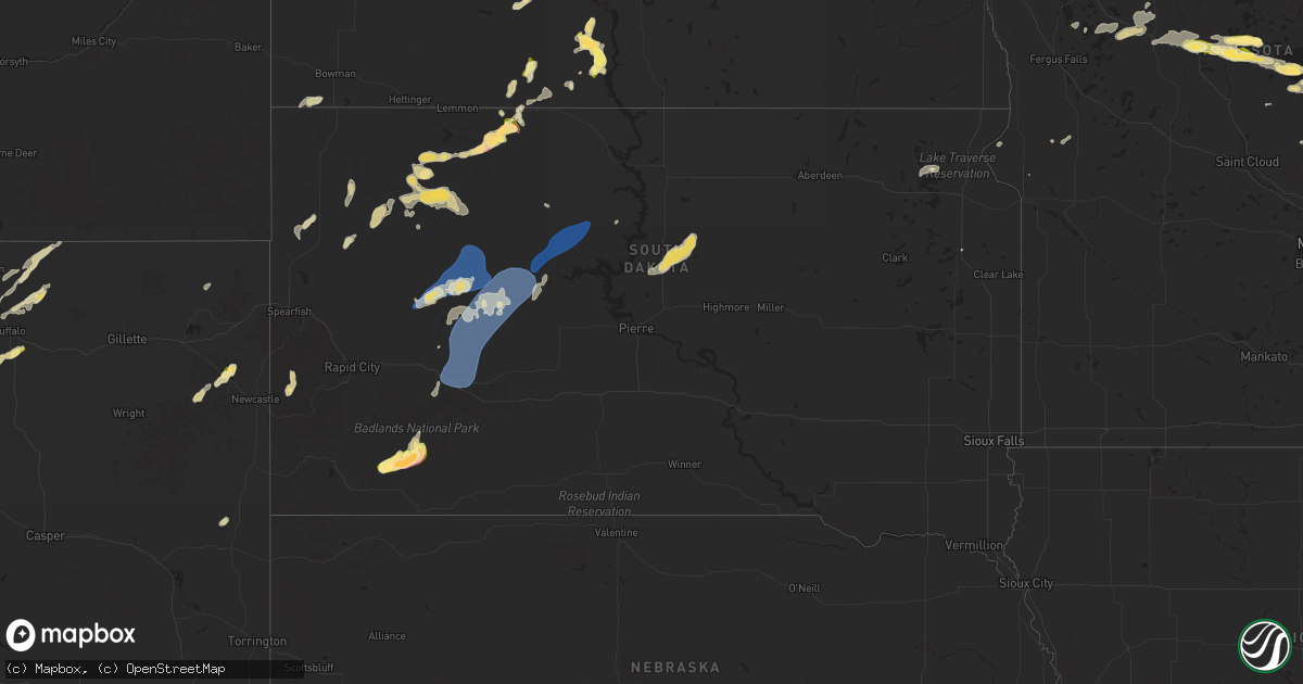
Hail Map in South Dakota on September 12, 2025
Get this storm
September 12 map
$229
one time, instant access
Download today. No call, no setup
Keep the $229
Bought the map and want the full workflow? Apply the entire $229 to a subscription within 7 days. None of it is wasted.
Every map, not just this one
This buys you this map. Subscription and you get every map we run, in the markets you choose from a few cities to whole states to nationwide. Plus real-time alerts the moment a storm fires.
Contact data
Name, contact info, occupancy, even credit band for addresses in the footprint. You go from where it hit to who to call.
Become the source they trust
Unlimited branding weather history reports on demand. You already have the documented answer ready for the property owner, and you are the one who showed up with it.
Property data and RoofTrace estimates
Pull up any address you have got, its value and the exact code rules for that jurisdiction, straight from One Click Code. Then RoofTrace estimates the squares, pitch, and roof value, priced the way you price.
Storm reports in South Dakota
South Dakota
| Date | Description |
|---|---|
| 09/12/20256:58 PM CDT | Golf-ball hail for about 15 minutes. Flooding of the yard. |
| 09/12/20254:35 AM CDT | A local report indicates 58 MPH wind near 1 NNE Faith |
| 09/12/20254:07 AM CDT | A local report indicates 59 MPH wind near Howes |
| 09/12/202512:31 AM CDT | A local report indicates 63 MPH wind near 2 SW Bridger |
| 09/12/202512:26 AM CDT | A local report indicates 62 MPH wind near 2 SW Bridger |
| 09/12/202512:25 AM CDT | A local report indicates 67 MPH wind near 11 W Milesville |
| 09/12/202512:21 AM CDT | A local report indicates 58 MPH wind near 2 SW Bridger |
| 09/12/202512:20 AM CDT | A local report indicates 62 MPH wind near 11 W Milesville |
| 09/11/20257:05 PM CDT | Time estimated. |
All States Impacted by Hail Map on September 12, 2025
Cities Impacted by Hail Map on September 12, 2025
- Anamoose, ND
- Hanksville, UT
- Dent, MN
- Erhard, MN
- Escalante, UT
- Puposky, MN
- Tenstrike, MN
- Hines, MN
- Richville, MN
- Perham, MN
- Ottertail, MN
- New York Mills, MN
- Wadena, MN
- Deer Creek, MN
- Sebeka, MN
- Bluffton, MN
- Staples, MN
- Verndale, MN
- Kelliher, MN
- Thompson, UT
- Motley, MN
- Harvey, ND
- Watertown, SD
- Fessenden, ND
- Green River, UT
- Winkelman, AZ
- Pillager, MN
- Aldrich, MN
- Brainerd, MN
- Nisswa, MN
- Pequot Lakes, MN
- Northome, MN
- Grenville, SD
- Waubay, SD
- Cathay, ND
- Mizpah, MN
- Wyarno, WY
- Clearmont, WY
- San Carlos, AZ
- Peridot, AZ
- Chambers, AZ
- Ganado, AZ
- Baxter, MN
- Sheridan, WY
- Roslyn, SD
- Ironton, MN
- Merrifield, MN
- Webster, SD
- De Beque, CO
- Fort Ripley, MN
- Wirt, MN
- Donnelly, MN
- Chinle, AZ
- Garrison, MN
- Cook, MN
- Angora, MN
- Hillman, MN
- Onamia, MN
- Clinton, MN
- Ray, ND
- Beardsley, MN
- Browns Valley, MN
- Isle, MN
- Wahkon, MN
- Oracle, AZ
- San Manuel, AZ
- Banner, WY
- Buffalo, WY
- Blanding, UT
- Ramah, NM
- Bluewater, NM
- Monticello, UT
- Homestead, FL
- Crownpoint, NM
- Willcox, AZ
- Pierz, MN
- Lake Powell, UT
- Milaca, MN
- Moab, UT
- Pima, AZ
- Farmington, NM
- Geyser, MT
- Rush City, MN
- Mora, MN
- Grasston, MN
- Braham, MN
- Stanchfield, MN
- Cochise, AZ
- Harris, MN
- Glade Park, CO
- Gateway, CO
- Lordsburg, NM
- Havre, MT
- Saint Croix Falls, WI
- Cushing, WI
- North Branch, MN
- Bloomfield, NM
- Raynesford, MT
- Grantsburg, WI
- Grand Junction, CO
- Fruita, CO
- Mack, CO
- Lewistown, MT
- Whitetail, MT
- Centuria, WI
- Melville, MT
- Big Sandy, MT
- Chinook, MT
- Rhame, ND
- Redstone, MT
- Shawmut, MT
- Lloyd, MT
- Buckhorn, NM
- San Simon, AZ
- Milltown, WI
- Balsam Lake, WI
- Amery, WI
- Belt, MT
- Bowman, ND
- Whitewater, CO
- Hays, MT
- Upton, WY
- Stockett, MT
- Newcastle, WY
- Superior, AZ
- Douglas, AZ
- McNeal, AZ
- Osage, WY
- Solen, ND
- Wolf Point, MT
- Grass Range, MT
- Lusk, WY
- Carson, ND
- Custer, SD
- Zortman, MT
- Fort Benton, MT
- Watauga, SD
- Poplar, MT
- Raleigh, ND
- Malta, MT
- Carter, MT
- Scobey, MT
- Cannon Ball, ND
- Fort Yates, ND
- Morristown, SD
- Dodson, MT
- Ten Sleep, WY
- New Leipzig, ND
- Selfridge, ND
- Mandan, ND
- Flasher, ND
- McIntosh, SD
- Hill City, SD
- Safford, AZ
- Plentywood, MT
- Saint Anthony, ND
- Keldron, SD
- Antelope, MT
- Morenci, AZ
- Clifton, AZ
- Cubero, NM
- Almont, ND
- New Salem, ND
- Dagmar, MT
- Westby, MT
- Fence Lake, NM
- Reserve, MT
- Meadow, SD
- Zuni, NM
- Brady, MT
- Grants, NM
- Belle Fourche, SD
- Flaxville, MT
- Hulett, WY
- Outlook, MT
- Devils Tower, WY
- Grenora, ND
- Bedrock, CO
- Pine Ridge, SD
- Lemmon, SD
- Kyle, SD
- Fortuna, ND
- Bison, SD
- Whiteriver, AZ
- Thatcher, AZ
- Vail, AZ
- Killdeer, ND
- Sonoita, AZ
- Show Low, AZ
- Newell, SD
- Ambrose, ND
- Animas, NM
- Crosby, ND
- Benson, AZ
- Dunn Center, ND
- Reva, SD
- Buffalo, SD
- Mud Butte, SD
- Watford City, ND
- Mandaree, ND
- Wall, SD
- Keene, ND
- Prairie City, SD
- Faith, SD
- Milesville, SD
- New Town, ND
- Medora, ND
- Lambert, MT
- Hettinger, ND
- Grassy Butte, ND
- Halliday, ND
- Roseglen, ND
- Froid, MT
- White Owl, SD
- Berthold, ND
- Enning, SD
- Agar, SD
- Onida, SD
- Union Center, SD
- Howes, SD
- Stanley, ND
- Gettysburg, SD
- Cherry Creek, SD
- Lebanon, SD
- Ross, ND
- Midland, SD
- Isabel, SD
- Dupree, SD
- Parshall, ND
- Palermo, ND
- Eagle Butte, SD
- Quinn, SD
- Philip, SD


