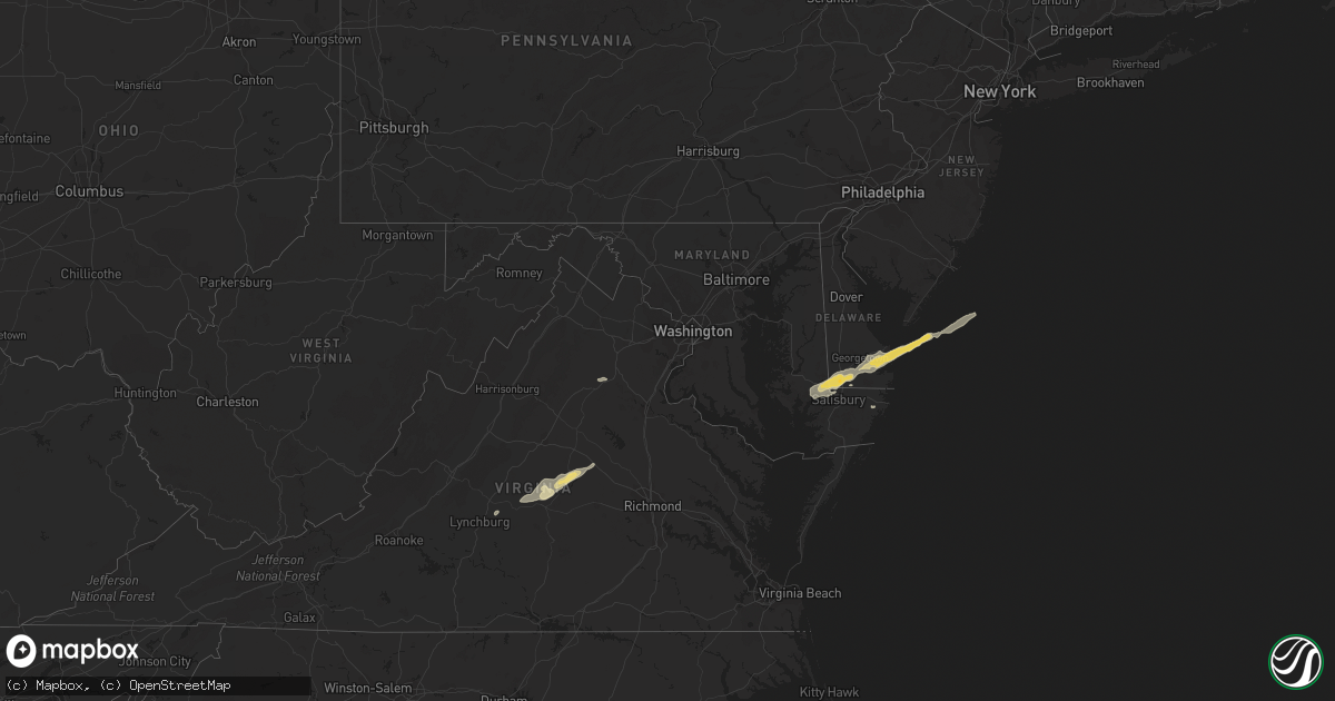
Hail Map in Delaware on September 12, 2022
Get this storm
September 12 map
$229
one time, instant access
Download today. No call, no setup
Keep the $229
Bought the map and want the full workflow? Apply the entire $229 to a subscription within 7 days. None of it is wasted.
Every map, not just this one
This buys you this map. Subscription and you get every map we run, in the markets you choose from a few cities to whole states to nationwide. Plus real-time alerts the moment a storm fires.
Contact data
Name, contact info, occupancy, even credit band for addresses in the footprint. You go from where it hit to who to call.
Become the source they trust
Unlimited branding weather history reports on demand. You already have the documented answer ready for the property owner, and you are the one who showed up with it.
Property data and RoofTrace estimates
Pull up any address you have got, its value and the exact code rules for that jurisdiction, straight from One Click Code. Then RoofTrace estimates the squares, pitch, and roof value, priced the way you price.
Storm reports in Delaware
Delaware
| Date | Description |
|---|---|
| 09/12/20224:14 AM CDT | Emergency management reports uprooted trees and power outages in the henlopen acres area north of rehoboth beach. Time estimated from radar. |
| 09/12/20224:14 AM CDT | Corrects time from previous tstm wnd dmg report from rehoboth beach. Emergency management reports numerous trees uprooted... Large tree limbs down... And power outages |
| 09/12/20224:10 AM CDT | Emergency management reports numerous trees uprooted... Large tree limbs down... And power outages mainly across the southern side of town. Notably impacted areas were |
| 09/12/20223:27 AM CDT | At 827 PM EDT, a severe thunderstorm was located over Centreville, or over Centerville, moving northeast at 30 mph. HAZARD...60 mph wind gusts. SOURCE...Radar indicated. IMPACT...Damage to roofs, siding, trees, and power lines is possible. Locations impacted include... Centerville, Chestertown, Centreville, Church Hill, Millington, Sudlersville, Old Town, Starr, Starkey Corner, Morgnec, Massey, Crumpton, Carville, Kennedyville, Hope, Galena, Barclay and Kingstown. |
All States Impacted by Hail Map on September 12, 2022
Cities Impacted by Hail Map on September 12, 2022
- Gladstone, NM
- Delmar, DE
- Laurel, DE
- Vail, AZ
- Conchas Dam, NM
- Parker, AZ
- Bowie, AZ
- San Simon, AZ
- Green Valley, AZ
- Amado, AZ
- Tombstone, AZ
- Huachuca City, AZ
- Sierra Vista, AZ
- Sonoita, AZ
- Elgin, AZ
- Trementina, NM
- Young, AZ
- Amherst, VA
- Madison Heights, VA
- Tumacacori, AZ
- Willcox, AZ
- Tucson, AZ
- Patagonia, AZ
- Scottsville, VA
- Arvonia, VA
- Dillwyn, VA
- Cochise, AZ
- Sahuarita, AZ
- Kearny, AZ
- Georgetown, DE
- Tubac, AZ
- Delmar, MD
- Mardela Springs, MD
- Hebron, MD
- Culpeper, VA
- Brandy Station, VA
- Eloy, AZ
- Sedona, AZ
- Nogales, AZ
- Clayton, NM
- Columbia, VA
- Palmyra, VA
- Bremo Bluff, VA
- Gladstone, VA
- New Canton, VA
- Louisa, VA
- Buckingham, VA
- Howardsville, VA
- Wingina, VA
- Fork Union, VA
- Kents Store, VA
- Berlin, MD
- Saint David, AZ
- Casa Grande, AZ
- Maricopa, AZ
- Harbeson, DE
- Millsboro, DE
- Milton, DE
- Vienna, MD
- Rehoboth Beach, DE
- Lewes, DE
- Bethel, DE
- Salisbury, MD
- Dagsboro, DE
- Rio Rico, AZ
- Ash Fork, AZ
- Payson, AZ
- Marana, AZ


