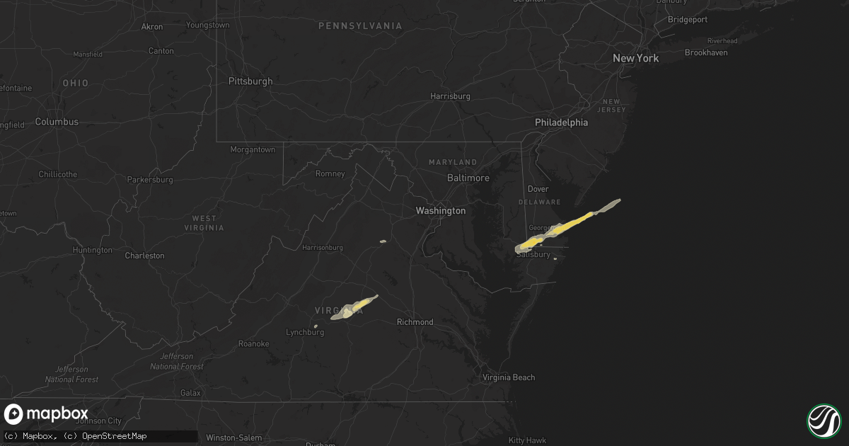
Hail Map in Maryland on September 12, 2022
Get this storm
September 12 map
$229
one time, instant access
Download today. No call, no setup
Keep the $229
Bought the map and want the full workflow? Apply the entire $229 to a subscription within 7 days. None of it is wasted.
Every map, not just this one
This buys you this map. Subscription and you get every map we run, in the markets you choose from a few cities to whole states to nationwide. Plus real-time alerts the moment a storm fires.
Contact data
Name, contact info, occupancy, even credit band for addresses in the footprint. You go from where it hit to who to call.
Become the source they trust
Unlimited branding weather history reports on demand. You already have the documented answer ready for the property owner, and you are the one who showed up with it.
Property data and RoofTrace estimates
Pull up any address you have got, its value and the exact code rules for that jurisdiction, straight from One Click Code. Then RoofTrace estimates the squares, pitch, and roof value, priced the way you price.
Storm reports in Maryland
Maryland
| Date | Description |
|---|---|
| 09/12/20224:12 PM CDT | Tree down near the intersection of nicodemus road and quarry view court |
| 09/12/20225:02 AM CDT | At 1002 PM EDT, a severe thunderstorm was located over Berlin, or 7 miles west of Ocean City, moving east at 25 mph. HAZARD...60 mph wind gusts. SOURCE...Radar indicated. IMPACT...Expect damage to trees and powerlines. This severe thunderstorm will be near... Ocean Pines around 1010 PM EDT. Cape Isle Of Wight around 1015 PM EDT. Ocean City around 1020 PM EDT.Other locations impacted by this severe thunderstorm includeIronshire, West Ocean City, Whaleyville, Showell and Ocean CityMunicipality. |
| 09/12/20222:45 AM CDT | At 745 PM EDT, a severe thunderstorm was located over Tilghman Island, or 10 miles southeast of Shady Side, moving northeast at 40 mph. HAZARD...60 mph wind gusts. SOURCE...Radar indicated. IMPACT...Damage to roofs, siding, trees, and power lines is possible. Locations impacted include... Easton, Centerville, Talbot, Denton, Centreville, Romancoke, Ridgely, St. Michaels, Queen Anne, Grasonville, Starr, Tilghman Island, Skipton, Copperville, Jumptown, Matthews, Wye Mills, Griffin, Cordova and Carville. |
| 09/12/20221:28 AM CDT | At 628 PM EDT, a severe thunderstorm was located near Colonial Beach, moving northeast at 25 mph. HAZARD...60 mph wind gusts and quarter size hail. SOURCE...Radar indicated. IMPACT...Damaging winds will cause some trees and large branches to fall. This could injure those outdoors, as well as damage homes and vehicles. Roadways may become blocked by downed trees. Localized power outages are possible. Unsecured light objects may become projectiles. Locations impacted include... Wicomico River, Golden Beach, Wicomico, Hughesville, Mechanicsville, Charlotte Hall, Cobb Island, Bryantown, Rock Point, Bushwood, Clements, Issue, Morganza, Tompkinsville, Hillville, Chaptico, Mount Victoria, Swan Point, Maddox and Avenue. |
| 09/11/202211:28 PM CDT | At 428 PM EDT, a severe thunderstorm was located near Triangle, or 7 miles west of Quantico, moving east at 15 mph. HAZARD...60 mph wind gusts. SOURCE...Radar indicated. IMPACT...Damaging winds will cause some trees and large branches to fall. This could injure those outdoors, as well as damage homes and vehicles. Roadways may become blocked by downed trees. Localized power outages are possible. Unsecured light objects may become projectiles. Locations impacted include... Quantico, Montclair, Triangle, Dumfries, Cherry Hill, Potomac Heights, Rison and Marbury. |
All States Impacted by Hail Map on September 12, 2022
Cities Impacted by Hail Map on September 12, 2022
- Gladstone, NM
- Delmar, DE
- Laurel, DE
- Vail, AZ
- Conchas Dam, NM
- Parker, AZ
- Bowie, AZ
- San Simon, AZ
- Green Valley, AZ
- Amado, AZ
- Tombstone, AZ
- Huachuca City, AZ
- Sierra Vista, AZ
- Sonoita, AZ
- Elgin, AZ
- Trementina, NM
- Young, AZ
- Amherst, VA
- Madison Heights, VA
- Tumacacori, AZ
- Willcox, AZ
- Tucson, AZ
- Patagonia, AZ
- Scottsville, VA
- Arvonia, VA
- Dillwyn, VA
- Cochise, AZ
- Sahuarita, AZ
- Kearny, AZ
- Georgetown, DE
- Tubac, AZ
- Delmar, MD
- Mardela Springs, MD
- Hebron, MD
- Culpeper, VA
- Brandy Station, VA
- Eloy, AZ
- Sedona, AZ
- Nogales, AZ
- Clayton, NM
- Columbia, VA
- Palmyra, VA
- Bremo Bluff, VA
- Gladstone, VA
- New Canton, VA
- Louisa, VA
- Buckingham, VA
- Howardsville, VA
- Wingina, VA
- Fork Union, VA
- Kents Store, VA
- Berlin, MD
- Saint David, AZ
- Casa Grande, AZ
- Maricopa, AZ
- Harbeson, DE
- Millsboro, DE
- Milton, DE
- Vienna, MD
- Rehoboth Beach, DE
- Lewes, DE
- Bethel, DE
- Salisbury, MD
- Dagsboro, DE
- Rio Rico, AZ
- Ash Fork, AZ
- Payson, AZ
- Marana, AZ


