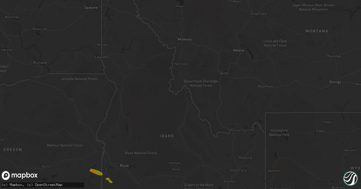
Hail Map in Idaho on September 6, 2019
Get this storm
September 6 map
$229
one time, instant access
Download today. No call, no setup
Keep the $229
Bought the map and want the full workflow? Apply the entire $229 to a subscription within 7 days. None of it is wasted.
Every map, not just this one
This buys you this map. Subscription and you get every map we run, in the markets you choose from a few cities to whole states to nationwide. Plus real-time alerts the moment a storm fires.
Contact data
Name, contact info, occupancy, even credit band for addresses in the footprint. You go from where it hit to who to call.
Become the source they trust
Unlimited branding weather history reports on demand. You already have the documented answer ready for the property owner, and you are the one who showed up with it.
Property data and RoofTrace estimates
Pull up any address you have got, its value and the exact code rules for that jurisdiction, straight from One Click Code. Then RoofTrace estimates the squares, pitch, and roof value, priced the way you price.
Storm reports in Idaho
Idaho
| Date | Description |
|---|---|
| 09/06/20193:00 PM CDT | Metal roofing peeled off of the yankee fork ranger building and six trees were blown down along the river. |
| 09/06/20193:00 PM CDT | A 61 mph wind gust was recorded by a trained spotter in challis at 2 pm . |
| 09/06/20192:47 PM CDT | Large tree branches down |
| 09/06/20197:44 AM CDT | At 1244 PM MDT, a severe thunderstorm was located 7 miles southeast of Twentymile Butte, or 24 miles southeast of Glenns Ferry, moving northeast at 30 mph. HAZARD...60 mph wind gusts and quarter size hail. SOURCE...Radar indicated. IMPACT...Hail damage to vehicles is expected. Expect wind damage to roofs, siding, and trees. This severe thunderstorm will be near... Hagerman and Buhl around 120 PM MDT. Gooding and Wendell around 130 PM MDT. |
| 09/06/20197:31 AM CDT | At 1230 PM MDT, a severe thunderstorm was located near Hot Springs Creek Reservoir, or 9 miles northwest of Glenns Ferry, moving northeast at 35 mph. HAZARD...60 mph wind gusts and quarter size hail. SOURCE...Radar indicated. IMPACT...Hail damage to vehicles is expected. Expect wind damage to roofs, siding, and trees. This severe thunderstorm will be near... Glenns Ferry and Blair Trail Reservoir around 1240 PM MDT. King Hill around 1250 PM MDT. Deer Heaven Mountain around 100 PM MDT. Davis Mountain, Hill City and White Arrow Hot Spring around 110 PM MDT. |
| 09/06/20196:33 AM CDT | At 1132 AM PDT, a severe thunderstorm was located 11 miles south of Mountain City, moving northeast at 30 mph. HAZARD...60 mph wind gusts and nickel size hail. SOURCE...Radar indicated. IMPACT...Expect damage to roofs, siding, and trees. Locations impacted include... Mountain City, Charleston and Wild Horse Reservoir. State Routes 226 and 225 will also be affected. Brief heavy rain may cause local flooding. Do not ever drive into flooded roads. |
| 09/06/201912:12 AM CDT | At 511 PM MDT, a severe thunderstorm was located over Squaw Butte, or 26 miles southwest of Nampa, moving southeast at 30 mph. HAZARD...60 mph wind gusts and quarter size hail. SOURCE...Radar indicated. IMPACT...Hail damage to vehicles is expected. Expect wind damage to roofs, siding, and trees. This severe thunderstorm will be near... Reynolds and Guffey around 530 PM MDT. Murphy around 540 PM MDT. Swan Falls around 600 PM MDT. |
| 09/05/201911:17 PM CDT | At 413 PM MDT, a severe thunderstorm was located 7 miles south of Lima, or 31 miles northwest of Dubois, moving east at 40 mph. HAZARD...60 mph wind gusts along with frequent lightning, brief heavy rain hail up to 1/2 inch in diameter. SOURCE...Radar indicated. A weather station located west of Clark Canyon reservoir observed a wind gust to 71 mph with this storm. IMPACT...Expect damage to roofs, siding, and trees. Locations impacted include... Lima, Monida and Clark Canyon Reservoir. |
| 09/05/20198:26 PM CDT | At 126 PM MDT, a severe thunderstorm was located near Castleford, or 18 miles west of Twin Falls, moving east at 25 mph. HAZARD...60 mph wind gusts and quarter size hail. SOURCE...Radar indicated. IMPACT...Hail damage to vehicles is expected. Expect wind damage to roofs, siding, and trees. This severe thunderstorm will be near... Buhl around 130 PM MDT. Filer around 150 PM MDT. Twin Falls and Magic Valley Regional Airport around 200 PM MDT. Jerome, Kimberly, Hansen and Rock Creek around 210 PM MDT. |
Cities Impacted by Hail Map on September 6, 2019
- Castle Rock, CO
- Larkspur, CO
- Riverside, OR
- Adrian, OR
- Sedalia, CO
- Morrison, CO
- Littleton, CO
- Golden, CO
- Evergreen, CO
- Idledale, CO
- Conifer, CO
- Lagrange, WY
- Central City, CO
- Englewood, CO
- Lone Tree, CO
- Black Hawk, CO
- Hammett, ID
- Glenns Ferry, ID
- Mccall, ID
- Monument, CO
- Prineville, OR
- Murphy, ID
- Laramie, WY
- Buhl, ID
- Broken Bow, NE
- Peyton, CO


