Hail Map on December 17, 2025
Get this storm
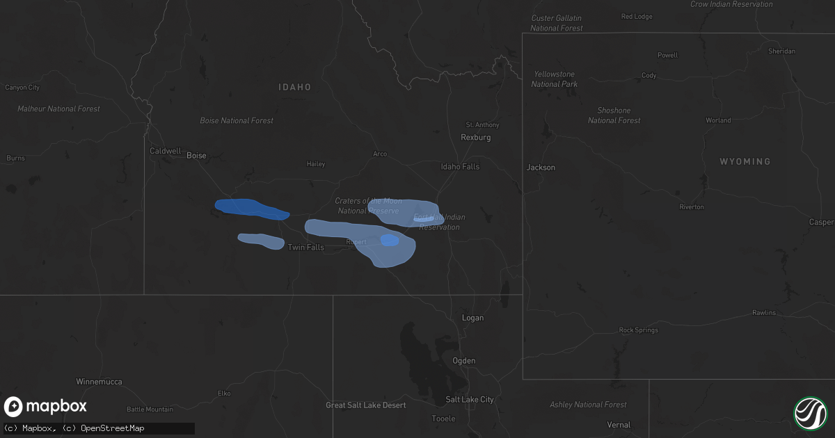
December 17 map
$229
one time, instant access
Download today. No call, no setup
Keep the $229
Bought the map and want the full workflow? Apply the entire $229 to a subscription within 7 days. None of it is wasted.
Every map, not just this one
This buys you this map. Subscription and you get every map we run, in the markets you choose from a few cities to whole states to nationwide. Plus real-time alerts the moment a storm fires.
Contact data
Name, contact info, occupancy, even credit band for addresses in the footprint. You go from where it hit to who to call.
Become the source they trust
Unlimited branding weather history reports on demand. You already have the documented answer ready for the property owner, and you are the one who showed up with it.
Property data and RoofTrace estimates
Pull up any address you have got, its value and the exact code rules for that jurisdiction, straight from One Click Code. Then RoofTrace estimates the squares, pitch, and roof value, priced the way you price.
States Impacted by Hail Map on December 17, 2025
Storm reports
Montana
| Date | Description |
|---|---|
| 12/17/202512:42 PM CST | Traffic sign bent over with debris blowing down the street. |
| 12/17/202512:42 PM CST | Traffic sign bent over wit |
Idaho
| Date | Description |
|---|---|
| 12/17/20251:00 PM CST | Mesonet station pc587 north willow. |
| 12/17/20251:00 PM CST | Mesonet station pc624 alpon east. |
| 12/17/202512:45 PM CST | Measured at the rocky point itd mesonet site. |
| 12/17/202512:40 PM CST | Mesonet station pc506 sheep creek hills. |
| 12/17/202512:15 PM CST | Mesonet station 3004 d4 juniper interchange i-84. |
| 12/17/202512:00 PM CST | Mesonet station prsut paris peak. |
| 12/17/202511:15 AM CST | Power outage to several hundred due to strong winds in the area. |
| 12/17/202511:10 AM CST | Measured near howard mountain at the idaho power mesonet site. |
| 12/17/202511:10 AM CST | Large tree down... Blocking roadway. |
| 12/17/202511:10 AM CST | Measured at the karen road idaho power mesonet site. |
| 12/17/202511:10 AM CST | Large... Mature pine tree blown over... Blocking driveway. |
| 12/17/202511:10 AM CST | Image from social media of large... Mature evergreen tree uprooted and blown onto power lines... Snapping one power line. |
| 12/17/202511:06 AM CST | Several hundred without power due to object on the lines. |
| 12/17/202511:01 AM CST | Asos station kpih pocatello regional airport. |
| 12/17/202511:00 AM CST | Law enforcement provided photos of multiple trees downed over highway 21. |
| 12/17/202511:00 AM CST | A member of the public posted a photo of a large fallen tree over the road... Blocking traffic. |
| 12/17/202511:00 AM CST | Member of |
| 12/17/202511:00 AM CST | A member of the public posted a photo of large rocks blocking the grimes creek pass road from strong thunderstorm winds. |
| 12/17/202511:00 AM CST | Member of the public posted a photo of a tree downed with entangled power lines over grimes pass road. |
| 12/17/202511:00 AM CST | Measured at the arbon valley itd mesonet site. |
| 12/17/202510:55 AM CST | Over 100 downed trees needed to be cleared on landmark road to provide access to yellow pine. |
| 12/17/202510:46 AM CST | Asos station ktwf twin falls. |
| 12/17/202510:45 AM CST | The idaho transportation department has closed i-84 eastbound between i-86 eastbound and milepost 245 due to multiple commercial vehicle rollovers associated with high |
| 12/17/202510:45 AM CST | Mesonet station 2248 d5 coldwater i-86. |
| 12/17/202510:44 AM CST | Mesonet station dehi1 deer haven. |
| 12/17/202510:42 AM CST | A member of the public posted a video of several large trees broken from thunderstorm winds... Blocking a driveway. |
| 12/17/202510:15 AM CST | Mesonet station 8401 d4 - valley interchange. |
| 12/17/202510:06 AM CST | A member of the public posted a photo of a large white elm tree downed by wind from a gust front. |
| 12/17/202510:03 AM CST | Kjer. |
| 12/17/202510:00 AM CST | Multiple photos provided by the public showing downed/snapped trees in and near cascade... Including one leaning on a house. |
| 12/17/202510:00 AM CST | Member of the public posted a photo of two pine trees downed on top of a house. |
| 12/17/202510:00 AM CST | Mesonet station 8408 d4 - jerome butte. |
| 12/17/202510:00 AM CST | Member of the public posted a photo of new roofing ripped off of a house. |
| 12/17/20259:45 AM CST | Mesonet station tgfi1 trail gulch. |
| 12/17/20259:30 AM CST | Asos station ktwf twin falls. |
| 12/17/20259:25 AM CST | Member of the public posted a photo of a downed tree resulting in fence damage. |
| 12/17/20259:10 AM CST | Numerous reports of downed trees and power lines. Several roads closed. Numerous power outages. |
| 12/17/20259:07 AM CST | Awos station kmuo mountain home afb. |
| 12/17/20258:46 AM CST | Mesonet station srfi1 snake river. |
| 12/17/20258:30 AM CST | Member of the public posted a photo of two downed trees. |
| 12/17/20258:30 AM CST | Mesonet station 8442 d4 - jackpot. |
| 12/17/20258:00 AM CST | Downed tree and power line critically injured 2 children waiting for a school bus. |
| 12/17/20257:54 AM CST | A local report indicates 66 MPH wind near Mccall |
Cities Impacted by Hail Map on December 17, 2025
- Mountain Home Afb, ID
- Mountain Home, ID
- Hammett, ID
- Glenns Ferry, ID
- Bruneau, ID
- King Hill, ID
- Bliss, ID
- Hagerman, ID
- Gooding, ID
- Buhl, ID
- Castleford, ID
- American Falls, ID
- Jerome, ID
- Eden, ID
- Paul, ID
- Hazelton, ID
- Shoshone, ID
- Rupert, ID
- Carey, ID
- Aberdeen, ID
- Pocatello, ID
- Firth, ID
- Pingree, ID
- Declo, ID
- Malta, ID
- Rockland, ID
- Springfield, ID
- Dietrich, ID