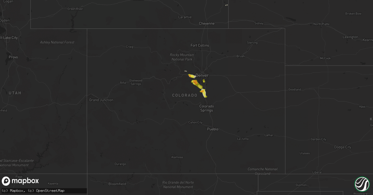
Hail Map in Colorado on September 6, 2019
Get this storm
September 6 map
$229
one time, instant access
Download today. No call, no setup
Keep the $229
Bought the map and want the full workflow? Apply the entire $229 to a subscription within 7 days. None of it is wasted.
Every map, not just this one
This buys you this map. Subscription and you get every map we run, in the markets you choose from a few cities to whole states to nationwide. Plus real-time alerts the moment a storm fires.
Contact data
Name, contact info, occupancy, even credit band for addresses in the footprint. You go from where it hit to who to call.
Become the source they trust
Unlimited branding weather history reports on demand. You already have the documented answer ready for the property owner, and you are the one who showed up with it.
Property data and RoofTrace estimates
Pull up any address you have got, its value and the exact code rules for that jurisdiction, straight from One Click Code. Then RoofTrace estimates the squares, pitch, and roof value, priced the way you price.
Storm reports in Colorado
Colorado
| Date | Description |
|---|---|
| 09/06/20196:00 PM CDT | A local report indicates 1.00 inch wind near 2 NNE MONUMENT |
| 09/06/20195:40 PM CDT | A local report indicates 1.25 inch wind near 2 NW LARKSPUR |
| 09/06/20194:35 PM CDT | Short lived tornado kicked up dust. |
| 09/06/20194:10 PM CDT | Pea to quarter size hail covering the ground. |
| 09/06/20194:05 PM CDT | A local report indicates 1.25 inch wind near 1 N EVERGREEN |
| 09/06/20193:13 PM CDT | A local report indicates 1.00 inch wind near 1.1 N BERGEN PARK |
| 09/06/20193:02 PM CDT | A local report indicates 1.00 inch wind near 2 WNW FLOYD HILL |
| 09/05/201911:51 PM CDT | At 451 PM MDT, a severe thunderstorm was located near Monument, or 17 miles north of Colorado Springs, moving southeast at 20 mph. HAZARD...60 mph wind gusts and half dollar size hail. SOURCE...Radar indicated. IMPACT...Hail damage to vehicles is expected. Expect wind damage to roofs, siding, and trees. Locations impacted include... Northern Colorado Springs, Monument, Air Force Academy, Palmer Lake, Black Forest and Gleneagle. |
| 09/05/201910:59 PM CDT | At 358 PM MDT, a severe thunderstorm was located near Castle Pines, or 18 miles southeast of Denver, moving east at 15 mph. HAZARD...60 mph wind gusts and quarter size hail. SOURCE...Radar indicated. IMPACT...Expect damage to roofs, siding, and trees. Hail damage to vehicles is expected. Locations impacted include... Eastern Denver, Aurora, Centennial, Highlands Ranch, Castle Rock, Parker, eastern Littleton, Greenwood Village, Lone Tree, Larkspur, Perry Park, The Pinery, Louviers, Arapahoe Park, Franktown, Buckley AFB, Castle Pines, Sedalia and Greenland. |
| 09/05/201910:26 PM CDT | At 325 PM MDT, a severe thunderstorm was located 5 miles southwest of Chatfield Reservoir, or 18 miles southwest of Denver, moving east at 15 mph. HAZARD...Quarter size hail. SOURCE...Radar indicated. IMPACT...Damage to vehicles is expected. Locations impacted include... Centennial, Highlands Ranch, Littleton, southwestern Englewood, Greenwood Village, Lone Tree, Roxborough Park, Chatfield Reservoir, Louviers, Sedalia, South Platte and northern Castle Pines. |
| 09/05/20199:44 PM CDT | At 244 PM MDT, a severe thunderstorm was located over Idledale, or 13 miles west of Denver, moving east at 15 mph. HAZARD...60 mph wind gusts and quarter size hail. SOURCE...Radar indicated. IMPACT...Expect damage to roofs, siding, and trees. Hail damage to vehicles is expected. Locations impacted include... Southwestern Denver, Lakewood, southwestern Centennial, northwestern Highlands Ranch, Littleton, Englewood, southern Wheat Ridge, Golden, Greenwood Village, Evergreen, Sheridan, Morrison, Idledale, Tiny Town, Chatfield Reservoir, Kittredge, Red Rocks Park, Indian Hills, Aspen Park and Bergen Park. |
| 09/05/20199:02 PM CDT | At 202 PM MDT, a severe thunderstorm was located near Floyd Hill, or 21 miles west of Denver, moving east at 15 mph. HAZARD...Quarter size hail. SOURCE...Radar indicated. IMPACT...Damage to vehicles is expected. Locations impacted include... Western Denver, Lakewood, Arvada, southwestern Westminster, northern Littleton, Wheat Ridge, Golden, Evergreen, Morrison, Idledale, Blue Valley, White Ranch Open Space, Kittredge, Red Rocks Park, Indian Hills, Brookvale, Bergen Park and Floyd Hill. |
Cities Impacted by Hail Map on September 6, 2019
- Castle Rock, CO
- Larkspur, CO
- Riverside, OR
- Adrian, OR
- Sedalia, CO
- Morrison, CO
- Littleton, CO
- Golden, CO
- Evergreen, CO
- Idledale, CO
- Conifer, CO
- Lagrange, WY
- Central City, CO
- Englewood, CO
- Lone Tree, CO
- Black Hawk, CO
- Hammett, ID
- Glenns Ferry, ID
- Mccall, ID
- Monument, CO
- Prineville, OR
- Murphy, ID
- Laramie, WY
- Buhl, ID
- Broken Bow, NE
- Peyton, CO


