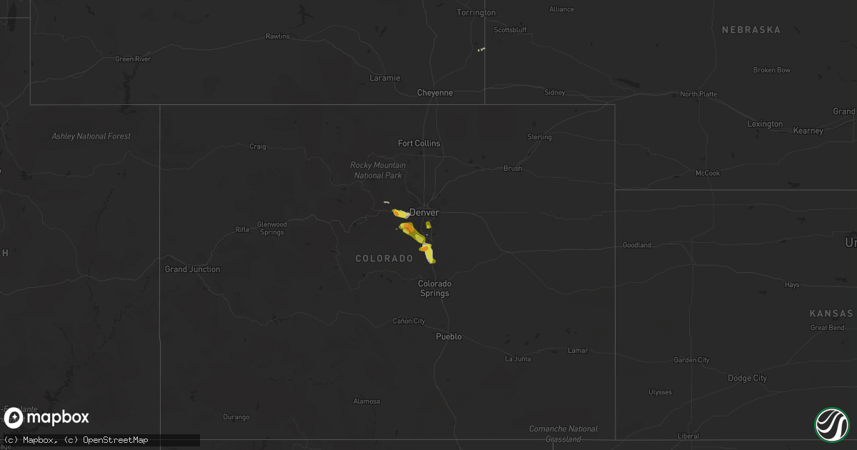
Hail Map on September 6, 2019
Get this storm
September 6 map
$229
one time, instant access
Download today. No call, no setup
Keep the $229
Bought the map and want the full workflow? Apply the entire $229 to a subscription within 7 days. None of it is wasted.
Every map, not just this one
This buys you this map. Subscription and you get every map we run, in the markets you choose from a few cities to whole states to nationwide. Plus real-time alerts the moment a storm fires.
Contact data
Name, contact info, occupancy, even credit band for addresses in the footprint. You go from where it hit to who to call.
Become the source they trust
Unlimited branding weather history reports on demand. You already have the documented answer ready for the property owner, and you are the one who showed up with it.
Property data and RoofTrace estimates
Pull up any address you have got, its value and the exact code rules for that jurisdiction, straight from One Click Code. Then RoofTrace estimates the squares, pitch, and roof value, priced the way you price.
Storm reports
Colorado
| Date | Description |
|---|---|
| 09/06/20196:00 PM CDT | A local report indicates 1.00 inch wind near 2 NNE MONUMENT |
| 09/06/20195:40 PM CDT | A local report indicates 1.25 inch wind near 2 NW LARKSPUR |
| 09/06/20194:35 PM CDT | Short lived tornado kicked up dust. |
| 09/06/20194:10 PM CDT | Pea to quarter size hail covering the ground. |
| 09/06/20194:05 PM CDT | A local report indicates 1.25 inch wind near 1 N EVERGREEN |
| 09/06/20193:13 PM CDT | A local report indicates 1.00 inch wind near 1.1 N BERGEN PARK |
| 09/06/20193:02 PM CDT | A local report indicates 1.00 inch wind near 2 WNW FLOYD HILL |
| 09/05/201911:51 PM CDT | At 451 PM MDT, a severe thunderstorm was located near Monument, or 17 miles north of Colorado Springs, moving southeast at 20 mph. HAZARD...60 mph wind gusts and half dollar size hail. SOURCE...Radar indicated. IMPACT...Hail damage to vehicles is expected. Expect wind damage to roofs, siding, and trees. Locations impacted include... Northern Colorado Springs, Monument, Air Force Academy, Palmer Lake, Black Forest and Gleneagle. |
| 09/05/201910:59 PM CDT | At 358 PM MDT, a severe thunderstorm was located near Castle Pines, or 18 miles southeast of Denver, moving east at 15 mph. HAZARD...60 mph wind gusts and quarter size hail. SOURCE...Radar indicated. IMPACT...Expect damage to roofs, siding, and trees. Hail damage to vehicles is expected. Locations impacted include... Eastern Denver, Aurora, Centennial, Highlands Ranch, Castle Rock, Parker, eastern Littleton, Greenwood Village, Lone Tree, Larkspur, Perry Park, The Pinery, Louviers, Arapahoe Park, Franktown, Buckley AFB, Castle Pines, Sedalia and Greenland. |
| 09/05/201910:26 PM CDT | At 325 PM MDT, a severe thunderstorm was located 5 miles southwest of Chatfield Reservoir, or 18 miles southwest of Denver, moving east at 15 mph. HAZARD...Quarter size hail. SOURCE...Radar indicated. IMPACT...Damage to vehicles is expected. Locations impacted include... Centennial, Highlands Ranch, Littleton, southwestern Englewood, Greenwood Village, Lone Tree, Roxborough Park, Chatfield Reservoir, Louviers, Sedalia, South Platte and northern Castle Pines. |
| 09/05/20199:44 PM CDT | At 244 PM MDT, a severe thunderstorm was located over Idledale, or 13 miles west of Denver, moving east at 15 mph. HAZARD...60 mph wind gusts and quarter size hail. SOURCE...Radar indicated. IMPACT...Expect damage to roofs, siding, and trees. Hail damage to vehicles is expected. Locations impacted include... Southwestern Denver, Lakewood, southwestern Centennial, northwestern Highlands Ranch, Littleton, Englewood, southern Wheat Ridge, Golden, Greenwood Village, Evergreen, Sheridan, Morrison, Idledale, Tiny Town, Chatfield Reservoir, Kittredge, Red Rocks Park, Indian Hills, Aspen Park and Bergen Park. |
| 09/05/20199:02 PM CDT | At 202 PM MDT, a severe thunderstorm was located near Floyd Hill, or 21 miles west of Denver, moving east at 15 mph. HAZARD...Quarter size hail. SOURCE...Radar indicated. IMPACT...Damage to vehicles is expected. Locations impacted include... Western Denver, Lakewood, Arvada, southwestern Westminster, northern Littleton, Wheat Ridge, Golden, Evergreen, Morrison, Idledale, Blue Valley, White Ranch Open Space, Kittredge, Red Rocks Park, Indian Hills, Brookvale, Bergen Park and Floyd Hill. |
Idaho
| Date | Description |
|---|---|
| 09/06/20193:00 PM CDT | Metal roofing peeled off of the yankee fork ranger building and six trees were blown down along the river. |
| 09/06/20193:00 PM CDT | A 61 mph wind gust was recorded by a trained spotter in challis at 2 pm . |
| 09/06/20192:47 PM CDT | Large tree branches down |
| 09/06/20197:44 AM CDT | At 1244 PM MDT, a severe thunderstorm was located 7 miles southeast of Twentymile Butte, or 24 miles southeast of Glenns Ferry, moving northeast at 30 mph. HAZARD...60 mph wind gusts and quarter size hail. SOURCE...Radar indicated. IMPACT...Hail damage to vehicles is expected. Expect wind damage to roofs, siding, and trees. This severe thunderstorm will be near... Hagerman and Buhl around 120 PM MDT. Gooding and Wendell around 130 PM MDT. |
| 09/06/20197:31 AM CDT | At 1230 PM MDT, a severe thunderstorm was located near Hot Springs Creek Reservoir, or 9 miles northwest of Glenns Ferry, moving northeast at 35 mph. HAZARD...60 mph wind gusts and quarter size hail. SOURCE...Radar indicated. IMPACT...Hail damage to vehicles is expected. Expect wind damage to roofs, siding, and trees. This severe thunderstorm will be near... Glenns Ferry and Blair Trail Reservoir around 1240 PM MDT. King Hill around 1250 PM MDT. Deer Heaven Mountain around 100 PM MDT. Davis Mountain, Hill City and White Arrow Hot Spring around 110 PM MDT. |
| 09/06/20196:33 AM CDT | At 1132 AM PDT, a severe thunderstorm was located 11 miles south of Mountain City, moving northeast at 30 mph. HAZARD...60 mph wind gusts and nickel size hail. SOURCE...Radar indicated. IMPACT...Expect damage to roofs, siding, and trees. Locations impacted include... Mountain City, Charleston and Wild Horse Reservoir. State Routes 226 and 225 will also be affected. Brief heavy rain may cause local flooding. Do not ever drive into flooded roads. |
| 09/06/201912:12 AM CDT | At 511 PM MDT, a severe thunderstorm was located over Squaw Butte, or 26 miles southwest of Nampa, moving southeast at 30 mph. HAZARD...60 mph wind gusts and quarter size hail. SOURCE...Radar indicated. IMPACT...Hail damage to vehicles is expected. Expect wind damage to roofs, siding, and trees. This severe thunderstorm will be near... Reynolds and Guffey around 530 PM MDT. Murphy around 540 PM MDT. Swan Falls around 600 PM MDT. |
| 09/05/201911:17 PM CDT | At 413 PM MDT, a severe thunderstorm was located 7 miles south of Lima, or 31 miles northwest of Dubois, moving east at 40 mph. HAZARD...60 mph wind gusts along with frequent lightning, brief heavy rain hail up to 1/2 inch in diameter. SOURCE...Radar indicated. A weather station located west of Clark Canyon reservoir observed a wind gust to 71 mph with this storm. IMPACT...Expect damage to roofs, siding, and trees. Locations impacted include... Lima, Monida and Clark Canyon Reservoir. |
| 09/05/20198:26 PM CDT | At 126 PM MDT, a severe thunderstorm was located near Castleford, or 18 miles west of Twin Falls, moving east at 25 mph. HAZARD...60 mph wind gusts and quarter size hail. SOURCE...Radar indicated. IMPACT...Hail damage to vehicles is expected. Expect wind damage to roofs, siding, and trees. This severe thunderstorm will be near... Buhl around 130 PM MDT. Filer around 150 PM MDT. Twin Falls and Magic Valley Regional Airport around 200 PM MDT. Jerome, Kimberly, Hansen and Rock Creek around 210 PM MDT. |
Nevada
| Date | Description |
|---|---|
| 09/06/20197:52 AM CDT | At 1252 PM PDT, a severe thunderstorm was located near Charleston, moving east at 15 mph. HAZARD...60 mph wind gusts and quarter size hail. SOURCE...Radar indicated. IMPACT...Hail damage to vehicles is expected. Expect wind damage to roofs, siding, and trees. Locations impacted include... Charleston. |
| 09/05/20198:04 PM CDT | At 104 PM PDT, a severe thunderstorm was located 16 miles south of Charleston, moving east at 15 mph. HAZARD...60 mph wind gusts and nickel size hail. SOURCE...Radar indicated. IMPACT...Expect damage to roofs, siding, and trees. Locations impacted include... Gibbs Ranch. |
Oregon
| Date | Description |
|---|---|
| 09/05/201911:05 PM CDT | At 405 PM MDT, a severe thunderstorm was located over Owyhee Reservoir, or 28 miles southwest of Parma, moving east at 20 mph. HAZARD...60 mph wind gusts and quarter size hail. SOURCE...Radar indicated. IMPACT...Hail damage to vehicles is expected. Expect wind damage to roofs, siding, and trees. This severe thunderstorm will be near... Board Corral Mountain, Slocum Creek Campground and Leslie Gulch around 420 PM MDT. Succor Creek Campground around 430 PM MDT. Rockville School around 450 PM MDT. Rockville, Squaw Butte, Elephant Butte and Malloy Ranch around 500 PM MDT. |
North Carolina
| Date | Description |
|---|---|
| 09/06/20195:40 AM CDT | Long creek tornado. Nws storm survey team found damage consistent with a tornado in long creek... Nc. Damage discovered on long creek loop road was determined to be cau |
| 09/05/201911:44 PM CDT | An ef0 tornado with 80 mph wind severely damaged 3 chicken houses and several other outbuildings along belvidere rd. |
Wyoming
| Date | Description |
|---|---|
| 09/06/20196:52 PM CDT | Trained spotter 24 nw douglas reported shed roof was torn off and 20 ft long stock panels weighting 250 lbs were knocked over. Wind estimated at 80 mph lasting for 10 s |
| 09/06/20196:10 PM CDT | Wydot mesonet station at shirley rim. |
| 09/06/20195:35 PM CDT | Wydot mesonet station halleck ridge along i-80. |
| 09/06/20195:20 PM CDT | Wydot mesonet station dana ridge along i-80. |
| 09/06/20195:00 PM CDT | Wydot mesonet station walcott junction along i-80. |
| 09/06/20194:57 PM CDT | Asos measured wind gust of 56 knots. |
| 09/06/20194:56 PM CDT | Asos measured 63 knots wind gust from thunderstorm outflow. |
| 09/05/201911:44 PM CDT | At 444 PM MDT, a severe thunderstorm was located 17 miles southeast of Pine Tree Junction, or 25 miles south of Wright, moving northeast at 20 mph. HAZARD...60 mph wind gusts and quarter size hail. SOURCE...Radar indicated. IMPACT...Hail damage to vehicles is expected. Expect wind damage to roofs, siding, and trees. Locations impacted include... Bill. |
| 09/05/201911:39 PM CDT | At 438 PM MDT, a severe thunderstorm was located near Glendo, or 21 miles southeast of Douglas, moving northeast at 25 mph. HAZARD...60 mph wind gusts and quarter size hail. SOURCE...Radar indicated. IMPACT...Hail damage to vehicles is expected. Expect wind damage to roofs, siding, and trees. Locations impacted include... Glendo, Sibley Peak, Glendo Reservoir, Two Moon Campground and Lost Springs.This includes Interstate 25 in Wyoming between mile markers 107 and125. |
| 09/05/201911:16 PM CDT | At 415 PM MDT, a severe thunderstorm was located 7 miles northeast of Muddy Gap, which is 24 miles east of Jeffrey City, moving northeast at 35 mph. HAZARD...60 mph wind gusts. SOURCE...Radar indicated. IMPACT...Expect damage to roofs, siding, and trees. This severe thunderstorm will be near... Devil's Gate around 420 PM MDT.Other locations impacted by this severe thunderstorm include AlcovaDam. |
| 09/05/201910:56 PM CDT | At 355 PM MDT, severe thunderstorms were located along a line extending from Green Mountain to 9 miles north of Jack Creek Campground, moving northeast at 40 mph. HAZARD...70 mph wind gusts. SOURCE...Trained weather spotters. IMPACT...Expect considerable tree damage. Damage is likely to mobile homes, roofs, and outbuildings. Locations impacted include... Rawlins, Saratoga, Hanna, Sinclair, Elk Mountain, Seminoe Campground, Seminoe Dam, Separation Lake, Jack Creek Campground, Bow River Campground, Muddy Gap and Teton Reservoir.This includes Interstate 80 in Wyoming between mile markers 200 and258. |
Montana
| Date | Description |
|---|---|
| 09/06/20195:19 PM CDT | Mesonet station tr267 beaverhead deerlodge no. 1. Time is estimated. |
| 09/06/20194:47 PM CDT | Mesonet station brrm8 brenner raws. Time estimated. |
Utah
| Date | Description |
|---|---|
| 09/06/201912:11 AM CDT | At 510 PM MDT, a severe thunderstorm was located 25 miles east of Montello, moving east at 40 mph. HAZARD...60 mph wind gusts and nickel size hail. SOURCE...Radar indicated. Locations impacted include... Utah Test and Training Range North. |
Cities Impacted by Hail Map on September 6, 2019
- Castle Rock, CO
- Larkspur, CO
- Riverside, OR
- Adrian, OR
- Sedalia, CO
- Morrison, CO
- Littleton, CO
- Golden, CO
- Evergreen, CO
- Idledale, CO
- Conifer, CO
- Lagrange, WY
- Central City, CO
- Englewood, CO
- Lone Tree, CO
- Black Hawk, CO
- Hammett, ID
- Glenns Ferry, ID
- Mccall, ID
- Monument, CO
- Prineville, OR
- Murphy, ID
- Laramie, WY
- Buhl, ID
- Broken Bow, NE
- Peyton, CO