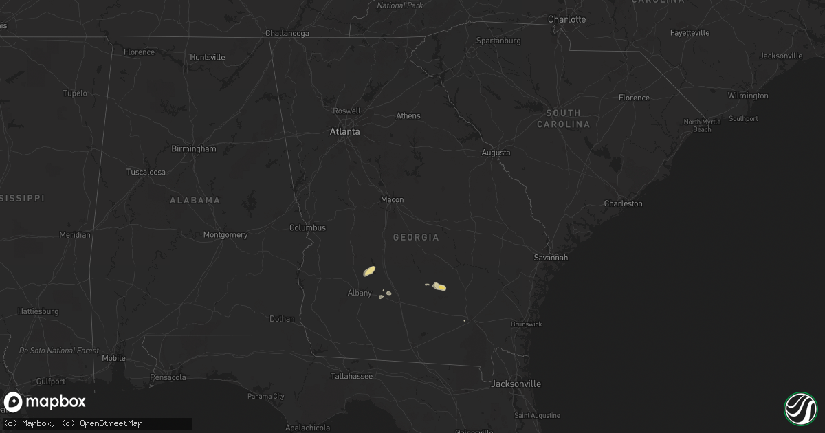
Hail Map in Georgia on August 30, 2017
Get this storm
August 30 map
$229
one time, instant access
Download today. No call, no setup
Keep the $229
Bought the map and want the full workflow? Apply the entire $229 to a subscription within 7 days. None of it is wasted.
Every map, not just this one
This buys you this map. Subscription and you get every map we run, in the markets you choose from a few cities to whole states to nationwide. Plus real-time alerts the moment a storm fires.
Contact data
Name, contact info, occupancy, even credit band for addresses in the footprint. You go from where it hit to who to call.
Become the source they trust
Unlimited branding weather history reports on demand. You already have the documented answer ready for the property owner, and you are the one who showed up with it.
Property data and RoofTrace estimates
Pull up any address you have got, its value and the exact code rules for that jurisdiction, straight from One Click Code. Then RoofTrace estimates the squares, pitch, and roof value, priced the way you price.
Storm reports in Georgia
Georgia
| Date | Description |
|---|---|
| 08/30/20176:12 PM CDT | Report of trees down across highway 82. Trees have already been cleared from the road. Time estimated with radar. |
| 08/30/20175:07 PM CDT | Power lines were blown down along rebecca s. Waldron road in the green acres area. The time of damage was based on radar. |
| 08/30/20174:50 PM CDT | Power lines were blown down across west green. |
| 08/30/20174:45 PM CDT | Power lines reported down across the road on highway 135. |
| 08/30/20174:45 PM CDT | Power lines reported down across the road on highway 135. |
| 08/30/20174:44 PM CDT | Power lines were blown down in the area between douglas and willacoochee. |
| 08/30/20174:42 PM CDT | Trees were blown down along brigmond road. |
| 08/30/20174:10 PM CDT | Tree downed on primrose road |
| 08/30/20172:35 PM CDT | A few power outages were due to wind in lee county |
| 08/30/20172:00 PM CDT | A few power outages were due to wind in terrell county |
Cities Impacted by Hail Map on August 30, 2017
- Cordele, GA
- Cobb, GA
- Leesburg, GA
- De Soto, GA
- New London, WI
- Lodgepole, NE
- Black Creek, WI
- Shiocton, WI
- Gays Mills, WI
- Boscobel, WI
- Pittsville, WI
- Adams, WI
- Friendship, WI
- Grand Marsh, WI
- Oxford, WI
- Pulaski, WI
- Bonduel, WI
- Sumner, GA
- Poulan, GA
- Westfield, WI
- Broxton, GA
- Wisconsin Dells, WI
- Hortonville, WI
- Sidney, NE
- Ashburn, GA
- Plainfield, WI
- Melrose, WI
- Sparta, WI
- Manawa, WI
- Oconto Falls, WI
- Porterfield, WI
- Seymour, WI
- Bear Creek, WI
- Clintonville, WI
- Athelstane, WI
- Suring, WI
- Mountain, WI
- Peshtigo, WI
- Marinette, WI
- Stanley, WI
- Thorp, WI
- Gilman, WI
- Douglas, GA
- Wray, GA
- Viola, WI
- Hillsboro, WI
- La Farge, WI
- Keshena, WI
- Appleton, WI
- Warwick, GA
- Amherst, WI
- Crivitz, WI
- New Lisbon, WI
- Mauston, WI
- Stephenson, MI
- Wausaukee, WI
- Gillett, WI
- South Range, WI
- Black River Falls, WI
- Mindoro, WI
- Fitzgerald, GA
- Ferryville, WI
- Taylor, WI
- Weyauwega, WI
- Wallace, MI
- Menominee, MI
- Amberg, WI
- Tifton, GA
- Ty Ty, GA
- Cazenovia, WI
- Richland Center, WI
- Woodland Park, CO
- Divide, CO
- Baker City, OR
- Wild Rose, WI
- Wautoma, WI
- De Soto, WI
- De Pere, WI
- Oneida, WI
- Pine River, WI
- Mosinee, WI
- Humbird, WI
- Alma Center, WI
- Pound, WI
- Wisconsin Rapids, WI
- Greenville, WI
- Embarrass, WI
- Nichols, WI
- Shawano, WI
- North Powder, OR
- Marion, WI
- Cecil, WI
- Littleton, CO
- West Green, GA
- Ambrose, GA
- Waycross, GA
- Hancock, WI
- Oconto, WI
- Lyndon Station, WI
- Wonewoc, WI
- Waupaca, WI
- Neshkoro, WI
- Ontario, WI
- Sylvester, GA
- Almond, WI


