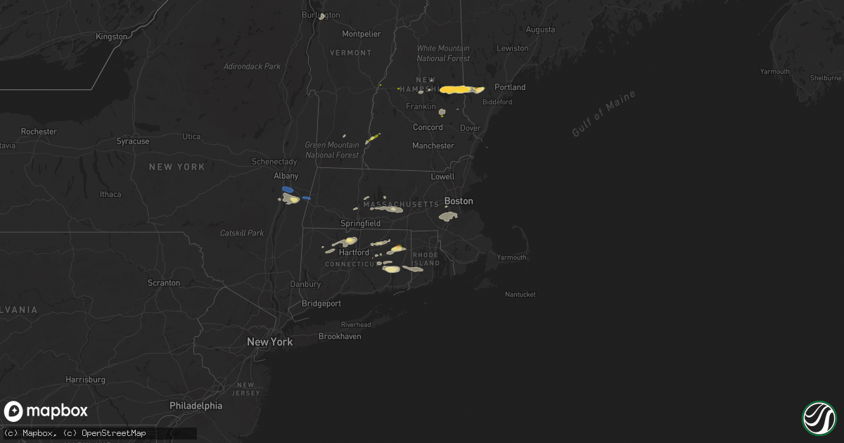
Hail Map in Connecticut on August 26, 2022
Get this storm
August 26 map
$229
one time, instant access
Download today. No call, no setup
Keep the $229
Bought the map and want the full workflow? Apply the entire $229 to a subscription within 7 days. None of it is wasted.
Every map, not just this one
This buys you this map. Subscription and you get every map we run, in the markets you choose from a few cities to whole states to nationwide. Plus real-time alerts the moment a storm fires.
Contact data
Name, contact info, occupancy, even credit band for addresses in the footprint. You go from where it hit to who to call.
Become the source they trust
Unlimited branding weather history reports on demand. You already have the documented answer ready for the property owner, and you are the one who showed up with it.
Property data and RoofTrace estimates
Pull up any address you have got, its value and the exact code rules for that jurisdiction, straight from One Click Code. Then RoofTrace estimates the squares, pitch, and roof value, priced the way you price.
Storm reports in Connecticut
Connecticut
| Date | Description |
|---|---|
| 08/26/20225:45 PM CDT | Multiple small trees |
| 08/26/20224:43 PM CDT | 12 downed trees near tyler drive. Time estimated by radar. |
| 08/26/20224:38 PM CDT | Trees down on route 207 near spafford drive and levita road. Time estimated from radar. |
| 08/26/20224:35 PM CDT | In hebron state police reported tree down on church street |
| 08/26/20223:42 PM CDT | Tree and wires down on north school rd. Relayed by amateur radio. Time estimated by radar. |
| 08/26/20223:37 PM CDT | Tree down on wires on goose lane near rockville. Relayed by amateur radio. |
| 08/26/20223:30 PM CDT | Large tree down on stone st in windsor. Relayed by amateur radio. |
| 08/26/20223:30 PM CDT | Tree and wires down on corner of spring and main street in rockville. Relayed by amateur radio. Time estimated by radar. |
| 08/26/20223:28 PM CDT | Report from mping: 3-inch tree limbs broken; power poles broken. |
| 08/26/20223:26 PM CDT | Trees down on sweetbrier st. Relayed by amateur radio. |
| 08/26/20223:22 PM CDT | 12 to 14 inch diameter trees were blown down in the median of hartford pike near dayville... Ct. Relayed by amateur radio. |
| 08/26/20223:10 PM CDT | Trees down on bridge st near enfield. Relayed by by amateur radio. |
| 08/26/20223:02 PM CDT | In east windsor numerous trees and wires were down... Particularly in broad brook section of town. The damage occurred from 402 to 426 pm. |
| 08/26/20222:53 PM CDT | In east granby... Trees were down on power lines on holcomb street. Also... Trees were down on metacomet drive and pond lane. Reports per ct state police. |
| 08/26/20222:50 PM CDT | Tree down and primary wires down at vineyard rd and belden rd. |
| 08/26/20222:50 PM CDT | Pole snapped and wires down on sandbank hill rd and claire hill road. |
| 08/26/20222:45 PM CDT | Wires down on lake road. |
| 08/26/20222:40 PM CDT | Tree and wires down; on smith lane at intersection of rt. 4. |
| 08/26/20222:09 PM CDT | Large branch fell on car on stephanie circle. |
| 08/26/20221:45 PM CDT | In east windsor a tree down on a house on pleasant street. |
| 08/26/20221:28 PM CDT | Tree and wires down on mahoney rd. Relayed by amateur radio. |
| 08/26/20221:28 PM CDT | Reported by amateur radio. |
| 08/26/20221:24 PM CDT | Tree down on winkler rd making road impassable. Relayed by amateur radio. |
| 08/26/20221:16 AM CDT | At 616 PM EDT, severe thunderstorms were located along a line extending from near Voluntown to Lisbon to near Colchester, moving east at 30 mph. HAZARD...60 mph wind gusts. SOURCE...Radar indicated. IMPACT...Expect damage to trees and power lines. Severe thunderstorms will be near... Jewett City and Lisbon around 620 PM EDT. Griswold around 625 PM EDT. Lebanon and Sprague around 630 PM EDT. Preston around 640 PM EDT. |
| 08/26/202212:27 AM CDT | At 526 PM EDT, a severe thunderstorm was located near Colchester, moving east at 30 mph. HAZARD...60 mph wind gusts and quarter size hail. SOURCE...Radar indicated. IMPACT...Minor hail damage to vehicles is possible. Expect wind damage to trees and power lines. This severe thunderstorm will be near... Salem around 535 PM EDT. Lebanon and Bozrah around 540 PM EDT. Sprague around 545 PM EDT. Norwich and Preston around 555 PM EDT. Jewett City and Lisbon around 600 PM EDT. Griswold around 605 PM EDT. Voluntown around 615 PM EDT. |
| 08/26/202212:06 AM CDT | At 505 PM EDT, a severe thunderstorm was located over Pomfret, or 12 miles northeast of Mansfield, moving east at 30 mph. HAZARD...60 mph wind gusts. SOURCE...Radar indicated. IMPACT...Expect damage to trees and power lines. Locations impacted include... Johnston, Smithfield, Killingly, Webster, Burrillville, Uxbridge, North Smithfield, Scituate, Glocester, Putnam, Thompson, Douglas, Brooklyn, Woodstock, Foster, Ashford, Pomfret, Millville, Chaplin and Hampton. |
| 08/25/202211:25 PM CDT | At 424 PM EDT, a severe thunderstorm was located near Brooklyn, or near Plainfield, moving east at 30 mph. HAZARD...60 mph wind gusts and quarter size hail. SOURCE...Radar indicated. IMPACT...Expect wind damage to trees and power lines. Minor hail damage to vehicles is possible. Locations impacted include... Cranston, Johnston, Plainfield, Smithfield, Killingly, Burrillville, North Smithfield, Scituate, Glocester, Brooklyn, Canterbury, Foster, Pomfret and Sterling. |
| 08/25/202211:24 PM CDT | At 424 PM EDT, severe thunderstorms were located along a line extending from Somers to Vernon to East Hartford, moving east at 30 mph. HAZARD...60 mph wind gusts and quarter size hail. SOURCE...Radar indicated. IMPACT...Expect wind damage to trees and power lines. Minor hail damage to vehicles is possible. Locations impacted include... Hartford, New Britain, Manchester, East Hartford, Enfield, Glastonbury, Newington, Vernon, Wethersfield, Mansfield, South Windsor, Windham, Willimantic, Southbridge, East Longmeadow, Ellington, Tolland, Charlton, Coventry and Stafford. |
| 08/25/202210:39 PM CDT | At 338 PM EDT, a severe thunderstorm was located over Burlington, or 7 miles east of Torrington, moving east at 25 mph. HAZARD...60 mph wind gusts and quarter size hail. SOURCE...Radar indicated. IMPACT...Expect wind damage to trees and power lines. Minor hail damage to vehicles is possible. Locations impacted include... Hartford, West Hartford, Manchester, East Hartford, Enfield, Windsor, South Windsor, Farmington, Simsbury, Bloomfield, Avon, Windsor Locks, East Windsor, Canton, Burlington and East Granby. |
| 08/25/202210:24 PM CDT | At 324 PM EDT, severe thunderstorms were located along a line extending from near Framingham to Douglas to Columbia, moving east at 35 mph. HAZARD...60 mph wind gusts and nickel size hail. SOURCE...Radar indicated. IMPACT...Expect damage to trees and power lines. Locations impacted include... Boston, Worcester, Cambridge, Quincy, Lynn, Newton, Somerville, Framingham, Waltham, Malden, Brookline, Manchester, Medford, Revere, Peabody, Arlington, Everett, Salem, Woonsocket and Marlborough. |
| 08/25/20229:58 PM CDT | At 257 PM EDT, a severe thunderstorm was located near Weston, or 8 miles northwest of Bridgeport, moving northeast at 25 mph. HAZARD...60 mph wind gusts and quarter size hail. SOURCE...Radar indicated. IMPACT...Minor hail damage to vehicles is possible. Expect wind damage to trees and power lines. This severe thunderstorm will be near... Trumbull around 310 PM EDT. Stratford around 315 PM EDT. Milford and Shelton around 320 PM EDT. Derby around 325 PM EDT. Seymour and Orange around 330 PM EDT. Woodbridge around 335 PM EDT. Naugatuck and Beacon Falls around 340 PM EDT. Hamden and Bethany around 345 PM EDT. |
All States Impacted by Hail Map on August 26, 2022
Cities Impacted by Hail Map on August 26, 2022
- Prestonsburg, KY
- Pikeville, KY
- Stanville, KY
- Flaxville, MT
- Milesville, SD
- Lakeside, MT
- Plentywood, MT
- Duchesne, UT
- Downey, ID
- Beattyville, KY
- Froid, MT
- Hudson, NY
- Chatham, NY
- Schodack Landing, NY
- Ghent, NY
- Valatie, NY
- Old Chatham, NY
- Stuyvesant, NY
- Coxsackie, NY
- West Coxsackie, NY
- East Chatham, NY
- Kinderhook, NY
- Stuyvesant Falls, NY
- Spartanburg, SC
- Redstone, MT
- Columbia, TN
- Kenna, WV
- Gandeeville, WV
- Sandyville, WV
- Reedy, WV
- Gay, WV
- Le Roy, WV
- Jamaica, VT
- Onamia, MN
- Hillman, MN
- Pierz, MN
- Grenora, ND
- Williston, ND
- Nashua, MT
- Moultonborough, NH
- Center Harbor, NH
- Heber, AZ
- Show Low, AZ
- Belchertown, MA
- Windsor, CT
- Bloomfield, CT
- East Granby, CT
- Simsbury, CT
- Tariffville, CT
- Saint Onge, SD
- Vale, SD
- Aladdin, WY
- Sundance, WY
- Union Center, SD
- Spearfish, SD
- New Underwood, SD
- Belle Fourche, SD
- Whitewood, SD
- Beulah, WY
- Newell, SD
- Alva, WY
- Sturgis, SD
- Nisland, SD
- Wolfeboro, NH
- Center Tuftonboro, NH
- Mirror Lake, NH
- Lebanon, TN
- Metropolis, IL
- Oak Park, MN
- Needham, MA
- Wellesley Hills, MA
- Needham Heights, MA
- Lebanon, CT
- Baltic, CT
- North Franklin, CT
- Cleveland, MN
- Madison Lake, MN
- Taylor, AZ
- Snowflake, AZ
- North Brookfield, MA
- South Burlington, VT
- Shelburne, VT
- Burlington, VT
- Montgomery, MN
- Lonsdale, MN
- Clear Lake, MN
- Bainville, MT
- Mora, MN
- Hays, MT
- Hulett, WY
- Park Rapids, MN
- Menahga, MN
- Custer, SD
- Ekalaka, MT
- Rozet, WY
- Gillette, WY
- Weston, WY
- Devils Tower, WY
- Moorcroft, WY
- Fort Pierre, SD
- Westby, MT
- Wyola, MT
- Aitkin, MN
- Climax, NY
- Malta, MT
- Meredith, NH
- Sanbornville, NH
- East Wakefield, NH
- Dodson, MT
- Philip, SD
- Lindstrom, MN
- Center City, MN
- Chapel Hill, TN
- Lewisburg, TN
- Fenelton, PA
- Cabot, PA
- Butler, PA
- Ware, MA
- New Braintree, MA
- Spencer, MA
- East Brookfield, MA
- Leicester, MA
- West Brookfield, MA
- Brockton, MT
- New Hampton, NH
- Fair Play, SC
- Westminster, SC
- Hampton, CT
- Pomfret Center, CT
- Mansfield Center, CT
- Danielson, CT
- Brooklyn, CT
- Chaplin, CT
- North Windham, CT
- Alzada, MT
- Decker, MT
- Chester, ID
- Ashton, ID
- Allen, SD
- Wanblee, SD
- Amherst, MA
- Winona, MN
- Antelope, MT
- Hayes, SD
- Hermosa, SD
- Keystone, SD
- Rapid City, SD
- West Kingston, RI
- Hope Valley, RI
- Voluntown, CT
- Exeter, RI
- Rockville, RI
- Jewett City, CT
- Wyoming, RI
- Fort Scott, KS
- Putney, VT
- Easthampton, MA
- Holyoke, MA
- Foreston, MN
- East Waterboro, ME
- Waterboro, ME
- Ossipee, NH
- Hollis Center, ME
- North Waterboro, ME
- West Newfield, ME
- Acton, ME
- Limerick, ME
- Shapleigh, ME
- Spring Hill, TN
- Whitetail, MT
- Lower Brule, SD
- Farmington, NH
- Raton, NM
- Gann Valley, SD
- Frazer, MT
- Weatogue, CT
- Windsor Locks, CT
- West Simsbury, CT
- Canton, CT
- New Hartford, CT
- Granby, CT
- Eastford, CT
- Ashford, CT
- Willington, CT
- Tolland, CT
- Faribault, MN
- Kilkenny, MN
- Buckhorn, KY
- Booneville, KY
- College Grove, TN
- Arrington, TN
- Nolensville, TN
- Alstead, NH
- Fort Thompson, SD
- Foley, MN
- Center Barnstead, NH
- Gilmanton Iron Works, NH
- Barnstead, NH
- Gilmanton, NH
- Needles, CA
- Hagerhill, KY
- East Point, KY
- Torrington, CT
- Bozrah, CT
- Taftville, CT
- Norwich, CT
- Preston, CT
- Yantic, CT
- Walpole, NH
- Flagstaff, AZ
- Hardwick, MA
- Burlington, CT
- Litchfield, CT
- Harwinton, CT
- Maxwell, NM
- Medicine Lake, MT
- Wolf Point, MT
- Wessington Springs, SD
- Dagmar, MT
- Soda Springs, ID
- Hinsdale, MT
- Opheim, MT
- Sanbornton, NH
- River Falls, WI
- Hastings, MN
- Princeton, MN
- Columbia, CT
- Andover, CT
- Gilman, CT
- Spencer, WV
- Medfield, MA
- Milton, MA
- Randolph, MA
- Norwood, MA
- Norfolk, MA
- Millis, MA
- Walpole, MA
- Dover, MA
- East Walpole, MA
- Dedham, MA
- Canton, MA
- Westwood, MA
- Sharon, MA
- Parsonsfield, ME
- Maple Lake, MN
- Annandale, MN
- Coventry, CT
- Becker, MN
- Monticello, MN
- Clearwater, MN
- Greer, SC
- Greenville, SC
- Pomeroy, OH
- Long Bottom, OH
- Interior, SD
- Hebron, CT
- Northfield, MN
- Selkirk, NY
- Ravena, NY
- Castleton On Hudson, NY
- Nassau, NY
- Canaan, NY
- Richmond, MA
- Pittsfield, MA
- Canaan, NH
- Pittsfield, NH
- Beach, ND
- Leupp, AZ
- White Owl, SD
- Howes, SD
- Enning, SD
- Scenic, SD
- Kyle, SD
- Kadoka, SD
- Pine Ridge, SD
- Quinn, SD
- Caputa, SD
- Wall, SD
- Midland, SD


