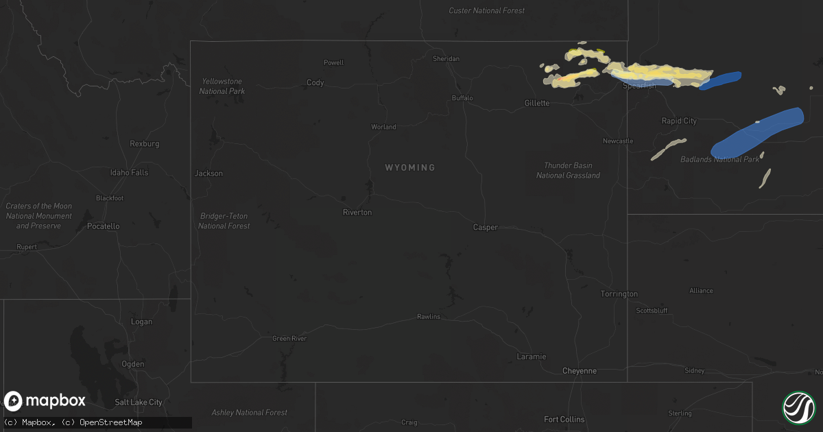
Hail Map in Wyoming on August 26, 2022
Get this storm
August 26 map
$229
one time, instant access
Download today. No call, no setup
Keep the $229
Bought the map and want the full workflow? Apply the entire $229 to a subscription within 7 days. None of it is wasted.
Every map, not just this one
This buys you this map. Subscription and you get every map we run, in the markets you choose from a few cities to whole states to nationwide. Plus real-time alerts the moment a storm fires.
Contact data
Name, contact info, occupancy, even credit band for addresses in the footprint. You go from where it hit to who to call.
Become the source they trust
Unlimited branding weather history reports on demand. You already have the documented answer ready for the property owner, and you are the one who showed up with it.
Property data and RoofTrace estimates
Pull up any address you have got, its value and the exact code rules for that jurisdiction, straight from One Click Code. Then RoofTrace estimates the squares, pitch, and roof value, priced the way you price.
Storm reports in Wyoming
Wyoming
| Date | Description |
|---|---|
| 08/26/20226:30 PM CDT | A lot of nickel to quarter size hail on the ground. |
| 08/26/20226:06 PM CDT | Time estimated via radar |
| 08/26/20226:00 PM CDT | Garden damage from hail. Time estimated by radar. |
| 08/26/20225:40 PM CDT | A local report indicates 1.00 inch wind near 15 NNW ALVA |
| 08/26/20221:12 AM CDT | At 611 PM MDT, severe thunderstorms were located along a line extending from 2 miles southwest of Colony to near Bear Lodge Campground to 7 miles west of Cook Lake, moving southeast at 35 mph. HAZARD...70 mph wind gusts and quarter size hail. SOURCE...Radar indicated. IMPACT...Hail damage to vehicles is expected. Expect considerable tree damage. Wind damage is also likely to mobile homes, roofs, and outbuildings. Severe thunderstorms will be near... Colony around 615 PM MDT. Aladdin around 620 PM MDT. Warren Peak around 625 PM MDT.Other locations in the path of these severe thunderstorms includeSundance, Beulah, Belle Fourche, Crow Peak, Fruitdale, Bridal VeilFalls, Spearfish, Saint Onge, Cement Ridge Lookout and SpearfishCanyon.This includes... Interstate 90 in South Dakota between Mile Markers 1 and 28. Interstate 90 in Wyoming between Mile Markers 185 and 207. |
| 08/26/202212:41 AM CDT | At 541 PM MDT, a severe thunderstorm was located 11 miles southwest of Oshoto, or 23 miles northeast of Gillette, moving east at 30 mph. HAZARD...60 mph wind gusts and quarter size hail. SOURCE...Radar indicated. IMPACT...Hail damage to vehicles is expected. Expect wind damage to roofs, siding, and trees. This severe thunderstorm will be near... Oshoto around 600 PM MDT.Other locations in the path of this severe thunderstorm includeCarlile, Devils Tower National Monument and Devils Tower Junction. |
| 08/26/202212:22 AM CDT | At 522 PM MDT, severe thunderstorms were located along a line extending from 10 miles north of Alva to 7 miles northwest of New Haven to 11 miles northwest of Oshoto, moving east at 35 mph. HAZARD...70 mph wind gusts and quarter size hail. SOURCE...Radar indicated. IMPACT...Hail damage to vehicles is expected. Expect considerable tree damage. Wind damage is also likely to mobile homes, roofs, and outbuildings. Locations impacted include... Colony, Hulett and Alva. |
| 08/26/202212:10 AM CDT | At 510 PM MDT, severe thunderstorms were located along a line extending from 2 miles south of Rockypoint to 13 miles northwest of Oshoto to 5 miles south of Weston, moving east at 20 mph. HAZARD...60 mph wind gusts and quarter size hail. SOURCE...Radar indicated. IMPACT...Hail damage to vehicles is expected. Expect wind damage to roofs, siding, and trees. Severe thunderstorms will be near... Rockypoint around 515 PM MDT. |
| 08/25/202211:41 PM CDT | At 440 PM MDT, a severe thunderstorm was located 4 miles southwest of Oshoto, or 30 miles northeast of Gillette, moving east at 10 mph. HAZARD...Ping pong ball size hail. SOURCE...Radar indicated. IMPACT...People and animals outdoors will be injured. Expect damage to roofs, siding, windows, and vehicles. This severe thunderstorm will be near... Oshoto around 500 PM MDT.Other locations in the path of this severe thunderstorm includeCarlile and Devils Tower National Monument. |
| 08/25/202211:25 PM CDT | At 424 PM MDT, severe thunderstorms were located along a line extending from 11 miles west of Alzada to 14 miles north of Hulett to 7 miles southeast of Rockypoint, moving east at 30 mph. HAZARD...60 mph wind gusts and quarter size hail. SOURCE...Radar indicated. IMPACT...Hail damage to vehicles is expected. Expect wind damage to roofs, siding, and trees. Locations impacted include... Colony. |
| 08/25/20227:42 PM CDT | A local report indicates 63 MPH wind near BEULAH |
| 08/25/20227:36 PM CDT | A local report indicates 62 MPH wind near BEULAH |
All States Impacted by Hail Map on August 26, 2022
Cities Impacted by Hail Map on August 26, 2022
- Prestonsburg, KY
- Pikeville, KY
- Stanville, KY
- Flaxville, MT
- Milesville, SD
- Lakeside, MT
- Plentywood, MT
- Duchesne, UT
- Downey, ID
- Beattyville, KY
- Froid, MT
- Hudson, NY
- Chatham, NY
- Schodack Landing, NY
- Ghent, NY
- Valatie, NY
- Old Chatham, NY
- Stuyvesant, NY
- Coxsackie, NY
- West Coxsackie, NY
- East Chatham, NY
- Kinderhook, NY
- Stuyvesant Falls, NY
- Spartanburg, SC
- Redstone, MT
- Columbia, TN
- Kenna, WV
- Gandeeville, WV
- Sandyville, WV
- Reedy, WV
- Gay, WV
- Le Roy, WV
- Jamaica, VT
- Onamia, MN
- Hillman, MN
- Pierz, MN
- Grenora, ND
- Williston, ND
- Nashua, MT
- Moultonborough, NH
- Center Harbor, NH
- Heber, AZ
- Show Low, AZ
- Belchertown, MA
- Windsor, CT
- Bloomfield, CT
- East Granby, CT
- Simsbury, CT
- Tariffville, CT
- Saint Onge, SD
- Vale, SD
- Aladdin, WY
- Sundance, WY
- Union Center, SD
- Spearfish, SD
- New Underwood, SD
- Belle Fourche, SD
- Whitewood, SD
- Beulah, WY
- Newell, SD
- Alva, WY
- Sturgis, SD
- Nisland, SD
- Wolfeboro, NH
- Center Tuftonboro, NH
- Mirror Lake, NH
- Lebanon, TN
- Metropolis, IL
- Oak Park, MN
- Needham, MA
- Wellesley Hills, MA
- Needham Heights, MA
- Lebanon, CT
- Baltic, CT
- North Franklin, CT
- Cleveland, MN
- Madison Lake, MN
- Taylor, AZ
- Snowflake, AZ
- North Brookfield, MA
- South Burlington, VT
- Shelburne, VT
- Burlington, VT
- Montgomery, MN
- Lonsdale, MN
- Clear Lake, MN
- Bainville, MT
- Mora, MN
- Hays, MT
- Hulett, WY
- Park Rapids, MN
- Menahga, MN
- Custer, SD
- Ekalaka, MT
- Rozet, WY
- Gillette, WY
- Weston, WY
- Devils Tower, WY
- Moorcroft, WY
- Fort Pierre, SD
- Westby, MT
- Wyola, MT
- Aitkin, MN
- Climax, NY
- Malta, MT
- Meredith, NH
- Sanbornville, NH
- East Wakefield, NH
- Dodson, MT
- Philip, SD
- Lindstrom, MN
- Center City, MN
- Chapel Hill, TN
- Lewisburg, TN
- Fenelton, PA
- Cabot, PA
- Butler, PA
- Ware, MA
- New Braintree, MA
- Spencer, MA
- East Brookfield, MA
- Leicester, MA
- West Brookfield, MA
- Brockton, MT
- New Hampton, NH
- Fair Play, SC
- Westminster, SC
- Hampton, CT
- Pomfret Center, CT
- Mansfield Center, CT
- Danielson, CT
- Brooklyn, CT
- Chaplin, CT
- North Windham, CT
- Alzada, MT
- Decker, MT
- Chester, ID
- Ashton, ID
- Allen, SD
- Wanblee, SD
- Amherst, MA
- Winona, MN
- Antelope, MT
- Hayes, SD
- Hermosa, SD
- Keystone, SD
- Rapid City, SD
- West Kingston, RI
- Hope Valley, RI
- Voluntown, CT
- Exeter, RI
- Rockville, RI
- Jewett City, CT
- Wyoming, RI
- Fort Scott, KS
- Putney, VT
- Easthampton, MA
- Holyoke, MA
- Foreston, MN
- East Waterboro, ME
- Waterboro, ME
- Ossipee, NH
- Hollis Center, ME
- North Waterboro, ME
- West Newfield, ME
- Acton, ME
- Limerick, ME
- Shapleigh, ME
- Spring Hill, TN
- Whitetail, MT
- Lower Brule, SD
- Farmington, NH
- Raton, NM
- Gann Valley, SD
- Frazer, MT
- Weatogue, CT
- Windsor Locks, CT
- West Simsbury, CT
- Canton, CT
- New Hartford, CT
- Granby, CT
- Eastford, CT
- Ashford, CT
- Willington, CT
- Tolland, CT
- Faribault, MN
- Kilkenny, MN
- Buckhorn, KY
- Booneville, KY
- College Grove, TN
- Arrington, TN
- Nolensville, TN
- Alstead, NH
- Fort Thompson, SD
- Foley, MN
- Center Barnstead, NH
- Gilmanton Iron Works, NH
- Barnstead, NH
- Gilmanton, NH
- Needles, CA
- Hagerhill, KY
- East Point, KY
- Torrington, CT
- Bozrah, CT
- Taftville, CT
- Norwich, CT
- Preston, CT
- Yantic, CT
- Walpole, NH
- Flagstaff, AZ
- Hardwick, MA
- Burlington, CT
- Litchfield, CT
- Harwinton, CT
- Maxwell, NM
- Medicine Lake, MT
- Wolf Point, MT
- Wessington Springs, SD
- Dagmar, MT
- Soda Springs, ID
- Hinsdale, MT
- Opheim, MT
- Sanbornton, NH
- River Falls, WI
- Hastings, MN
- Princeton, MN
- Columbia, CT
- Andover, CT
- Gilman, CT
- Spencer, WV
- Medfield, MA
- Milton, MA
- Randolph, MA
- Norwood, MA
- Norfolk, MA
- Millis, MA
- Walpole, MA
- Dover, MA
- East Walpole, MA
- Dedham, MA
- Canton, MA
- Westwood, MA
- Sharon, MA
- Parsonsfield, ME
- Maple Lake, MN
- Annandale, MN
- Coventry, CT
- Becker, MN
- Monticello, MN
- Clearwater, MN
- Greer, SC
- Greenville, SC
- Pomeroy, OH
- Long Bottom, OH
- Interior, SD
- Hebron, CT
- Northfield, MN
- Selkirk, NY
- Ravena, NY
- Castleton On Hudson, NY
- Nassau, NY
- Canaan, NY
- Richmond, MA
- Pittsfield, MA
- Canaan, NH
- Pittsfield, NH
- Beach, ND
- Leupp, AZ
- White Owl, SD
- Howes, SD
- Enning, SD
- Scenic, SD
- Kyle, SD
- Kadoka, SD
- Pine Ridge, SD
- Quinn, SD
- Caputa, SD
- Wall, SD
- Midland, SD


