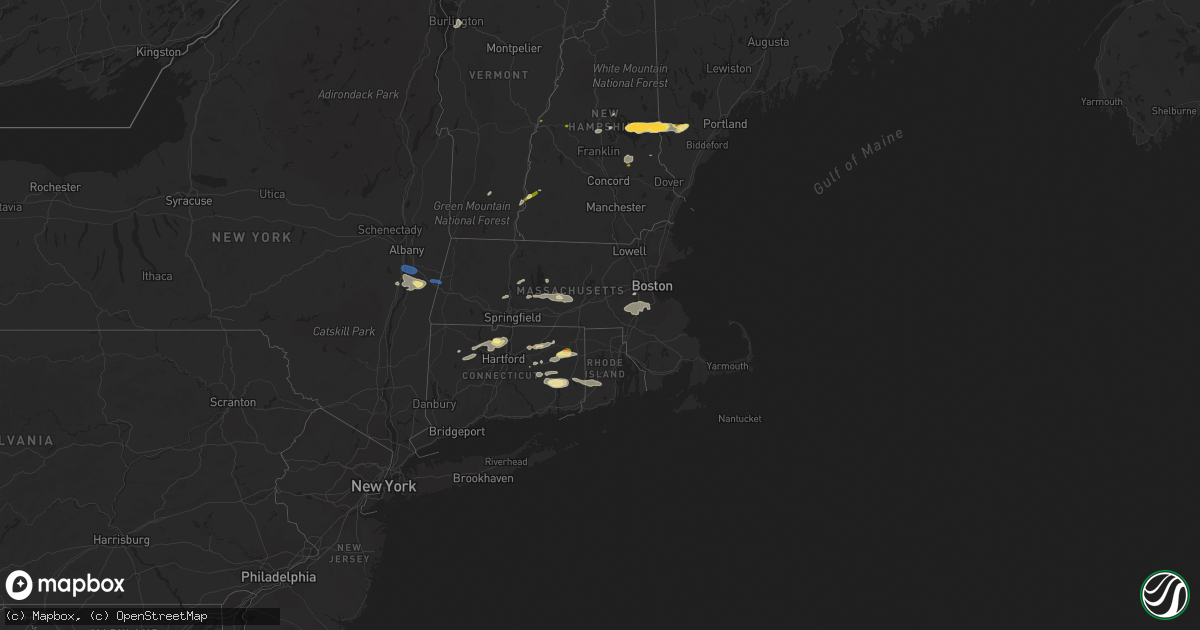
Hail Map in Massachusetts on August 26, 2022
Get this storm
August 26 map
$229
one time, instant access
Download today. No call, no setup
Keep the $229
Bought the map and want the full workflow? Apply the entire $229 to a subscription within 7 days. None of it is wasted.
Every map, not just this one
This buys you this map. Subscription and you get every map we run, in the markets you choose from a few cities to whole states to nationwide. Plus real-time alerts the moment a storm fires.
Contact data
Name, contact info, occupancy, even credit band for addresses in the footprint. You go from where it hit to who to call.
Become the source they trust
Unlimited branding weather history reports on demand. You already have the documented answer ready for the property owner, and you are the one who showed up with it.
Property data and RoofTrace estimates
Pull up any address you have got, its value and the exact code rules for that jurisdiction, straight from One Click Code. Then RoofTrace estimates the squares, pitch, and roof value, priced the way you price.
Storm reports in Massachusetts
Massachusetts
| Date | Description |
|---|---|
| 08/26/20223:52 PM CDT | Large tree fell on a house on sanford dr in hingham. Relayed by amateur radio. Report time estimated by radar. |
| 08/26/20223:50 PM CDT | Tree down on lincoln st near hingham. Relayed by amateur radio. Report time estimated by radar. |
| 08/26/20223:47 PM CDT | Trees down on coolidge rd near weymouth. Relayed by trained spotters. Report time estimated by radar. |
| 08/26/20223:46 PM CDT | Trees down on presidents rd near weymouth. Report time estimated by radar. |
| 08/26/20223:10 PM CDT | Tree down on house on frost street... Wires down on perry street. |
| 08/26/20222:42 PM CDT | Tree down onjames street. |
| 08/26/20222:42 PM CDT | Tree down on winch st near framingham. Relayed by amateur radio. |
| 08/26/20222:33 PM CDT | Large tree down on fahey st near marlborough. Relayed by amateur radio. Report time estimated by radar. |
| 08/26/20222:32 PM CDT | Several branches... A couple of trees and a couple of tents were blown down at 181 boston post rd west in marlborough. Relayed by amateur radio. Report time estimated b |
| 08/26/20222:25 PM CDT | Tree down closing road on lovell sreet. Power lines down on boston ave. |
| 08/26/20222:20 PM CDT | Tree down on house at ludlow and main street. |
| 08/26/20222:20 PM CDT | Trees down on rawon at burncoast street... Tree down on wire chapel street. |
| 08/26/20222:20 PM CDT | Trees down on rawon at bburncoast street... Tree down on wire chapel street. |
| 08/26/20222:20 PM CDT | Trees down on goddard drive... Scandanavia ave and main street. |
| 08/26/20222:17 PM CDT | Several trees down on plains road. |
| 08/26/20222:15 PM CDT | Reported by trained spotter. |
| 08/26/20221:04 PM CDT | Tree and powerlines downed on sheldon rd in barre. Relayed by amateur radio. Report time estimated by radar. |
| 08/26/20221:02 PM CDT | Trees and powerlines downed on old dana rd near barre. Relayed by amateur radio. Report time estimated by radar. |
| 08/26/20221:00 PM CDT | Trees and wires down on lenox rd. Time radar estimated. |
| 08/26/202212:59 PM CDT | Trees and wires down on swamp rd. Time radar estimated. |
| 08/25/202211:27 PM CDT | At 427 PM EDT, severe thunderstorms were located along a line extending from Lynn to Mansfield, moving east at 40 mph. HAZARD...60 mph wind gusts. SOURCE...Radar indicated. IMPACT...Expect damage to trees and power lines. Locations impacted include... Boston, Cambridge, Brockton, Quincy, Lynn, Somerville, Malden, Brookline, Taunton, Weymouth, Revere, Peabody, Everett, Salem, Braintree, Chelsea, Randolph, North Attleborough, Norwood and Milton. |
| 08/25/202210:42 PM CDT | At 341 PM EDT, a severe thunderstorm was located over East Granby, or near Windsor, moving east at 50 mph. HAZARD...60 mph wind gusts and quarter size hail. SOURCE...Radar indicated. IMPACT...Expect wind damage to trees and power lines. Minor hail damage to vehicles is possible. Locations impacted include... Enfield, Windsor, Simsbury, Bloomfield, Suffield, East Longmeadow, Ellington, Windsor Locks, Stafford, Somers, Granby, East Windsor, Canton, Monson, East Granby, Hampden, Brimfield, Holland, Wales and Union. |
| 08/25/202210:06 PM CDT | At 306 PM EDT, a severe thunderstorm was located near Pine Plains, or 9 miles northeast of Rhinebeck, moving east at 20 mph. HAZARD...60 mph wind gusts and penny size hail. SOURCE...Radar indicated. IMPACT...Expect damage to roofs, siding, and trees. Locations impacted include... Pine Plains, Ancram, Millerton, Bethel, Whitehouse Crossing, Pachin Mills, Ancramdale, Barton Corners, Boston Corner, Northeast Center, Gallatinville, Spencer Corners, Hammertown, Mount Riga, Mount Ross, Coleman Station, Shekomeko, Silvernails, Jackson Corners and Pulvers Corners. |
| 08/25/202210:03 PM CDT | At 302 PM EDT, a severe thunderstorm was located over Princeton, or near Leominster, moving east at 25 mph. HAZARD...60 mph wind gusts and quarter size hail. SOURCE...Radar indicated. IMPACT...Expect wind damage to trees and power lines. Minor hail damage to vehicles is possible. Locations impacted include... Lowell, Leominster, Marlborough, Chelmsford, Westford, Acton, Hudson, Concord, Sudbury, Holden, Northborough, Clinton, Wayland, Weston, Groton, Maynard, Lunenburg, Littleton, Lancaster and Rutland. |
| 08/25/20229:28 PM CDT | At 228 PM EDT, a severe thunderstorm was located over Petersham, or 13 miles southeast of Orange, moving east at 20 mph. HAZARD...60 mph wind gusts and quarter size hail. SOURCE...Radar indicated. IMPACT...Expect wind damage to trees and power lines. Minor hail damage to vehicles is possible. Locations impacted include... Gardner, Holden, Templeton, Rutland, Sterling, West Boylston, Westminster, Ashburnham, Barre, Hubbardston, Princeton, Hardwick, Oakham, Phillipston, Petersham and New Braintree. |
| 08/25/20229:27 PM CDT | At 227 PM EDT, a severe thunderstorm was located over Ware, or 11 miles southeast of Amherst, moving east at 50 mph. HAZARD...60 mph wind gusts and nickel size hail. SOURCE...Radar indicated. IMPACT...Expect damage to trees and power lines. Locations impacted include... Worcester, Framingham, Marlborough, Shrewsbury, Natick, Acton, Ludlow, Hudson, Westborough, Grafton, Concord, Sudbury, Holden, Ashland, Auburn, Hopkinton, Belchertown, Wilbraham, Northborough and Oxford. |
| 08/25/20228:41 PM CDT | At 140 PM EDT, a severe thunderstorm was located over Canton, or 10 miles east of Torrington, moving northeast at 30 mph. HAZARD...60 mph wind gusts and quarter size hail. SOURCE...Radar indicated. IMPACT...Expect wind damage to trees and power lines. Minor hail damage to vehicles is possible. Locations impacted include... Springfield, Enfield, Windsor, Agawam, West Springfield, Simsbury, Ludlow, Bloomfield, Longmeadow, Suffield, East Longmeadow, Wilbraham, Windsor Locks, Stafford, Somers, Granby, East Windsor, Canton, Southwick and Burlington. |
| 08/25/20228:15 PM CDT | At 114 PM EDT, a severe thunderstorm was located over Amherst, moving northeast at 35 mph. HAZARD...60 mph wind gusts and quarter size hail. SOURCE...Radar indicated. IMPACT...Expect wind damage to trees and power lines. Minor hail damage to vehicles is possible. Locations impacted include... Amherst, Orange, Gardner, Athol, Winchendon, Templeton, Westminster, Ashburnham, Barre, Hadley, Hubbardston, Princeton, Hatfield, Leverett, Shutesbury, Phillipston, Pelham, Royalston, Petersham and New Salem. |
| 08/25/20228:02 PM CDT | At 102 PM EDT, a severe thunderstorm was located over Selkirk, or 7 miles south of Delmar, moving east at 40 mph. HAZARD...60 mph wind gusts and nickel size hail. SOURCE...Radar indicated. IMPACT...Expect damage to roofs, siding, and trees. Locations impacted include... Pittsfield, East Greenbush, Rensselaer, Chatham, Nassau, Delmar, Lenox, New Baltimore, Ravena, Stephentown, Coxsackie, New Lebanon, Valatie, Castleton-On-Hudson, Kinderhook, Hancock, West Sand Lake, Averill Park, Selkirk and Feura Bush. |
All States Impacted by Hail Map on August 26, 2022
Cities Impacted by Hail Map on August 26, 2022
- Prestonsburg, KY
- Pikeville, KY
- Stanville, KY
- Flaxville, MT
- Milesville, SD
- Lakeside, MT
- Plentywood, MT
- Duchesne, UT
- Downey, ID
- Beattyville, KY
- Froid, MT
- Hudson, NY
- Chatham, NY
- Schodack Landing, NY
- Ghent, NY
- Valatie, NY
- Old Chatham, NY
- Stuyvesant, NY
- Coxsackie, NY
- West Coxsackie, NY
- East Chatham, NY
- Kinderhook, NY
- Stuyvesant Falls, NY
- Spartanburg, SC
- Redstone, MT
- Columbia, TN
- Kenna, WV
- Gandeeville, WV
- Sandyville, WV
- Reedy, WV
- Gay, WV
- Le Roy, WV
- Jamaica, VT
- Onamia, MN
- Hillman, MN
- Pierz, MN
- Grenora, ND
- Williston, ND
- Nashua, MT
- Moultonborough, NH
- Center Harbor, NH
- Heber, AZ
- Show Low, AZ
- Belchertown, MA
- Windsor, CT
- Bloomfield, CT
- East Granby, CT
- Simsbury, CT
- Tariffville, CT
- Saint Onge, SD
- Vale, SD
- Aladdin, WY
- Sundance, WY
- Union Center, SD
- Spearfish, SD
- New Underwood, SD
- Belle Fourche, SD
- Whitewood, SD
- Beulah, WY
- Newell, SD
- Alva, WY
- Sturgis, SD
- Nisland, SD
- Wolfeboro, NH
- Center Tuftonboro, NH
- Mirror Lake, NH
- Lebanon, TN
- Metropolis, IL
- Oak Park, MN
- Needham, MA
- Wellesley Hills, MA
- Needham Heights, MA
- Lebanon, CT
- Baltic, CT
- North Franklin, CT
- Cleveland, MN
- Madison Lake, MN
- Taylor, AZ
- Snowflake, AZ
- North Brookfield, MA
- South Burlington, VT
- Shelburne, VT
- Burlington, VT
- Montgomery, MN
- Lonsdale, MN
- Clear Lake, MN
- Bainville, MT
- Mora, MN
- Hays, MT
- Hulett, WY
- Park Rapids, MN
- Menahga, MN
- Custer, SD
- Ekalaka, MT
- Rozet, WY
- Gillette, WY
- Weston, WY
- Devils Tower, WY
- Moorcroft, WY
- Fort Pierre, SD
- Westby, MT
- Wyola, MT
- Aitkin, MN
- Climax, NY
- Malta, MT
- Meredith, NH
- Sanbornville, NH
- East Wakefield, NH
- Dodson, MT
- Philip, SD
- Lindstrom, MN
- Center City, MN
- Chapel Hill, TN
- Lewisburg, TN
- Fenelton, PA
- Cabot, PA
- Butler, PA
- Ware, MA
- New Braintree, MA
- Spencer, MA
- East Brookfield, MA
- Leicester, MA
- West Brookfield, MA
- Brockton, MT
- New Hampton, NH
- Fair Play, SC
- Westminster, SC
- Hampton, CT
- Pomfret Center, CT
- Mansfield Center, CT
- Danielson, CT
- Brooklyn, CT
- Chaplin, CT
- North Windham, CT
- Alzada, MT
- Decker, MT
- Chester, ID
- Ashton, ID
- Allen, SD
- Wanblee, SD
- Amherst, MA
- Winona, MN
- Antelope, MT
- Hayes, SD
- Hermosa, SD
- Keystone, SD
- Rapid City, SD
- West Kingston, RI
- Hope Valley, RI
- Voluntown, CT
- Exeter, RI
- Rockville, RI
- Jewett City, CT
- Wyoming, RI
- Fort Scott, KS
- Putney, VT
- Easthampton, MA
- Holyoke, MA
- Foreston, MN
- East Waterboro, ME
- Waterboro, ME
- Ossipee, NH
- Hollis Center, ME
- North Waterboro, ME
- West Newfield, ME
- Acton, ME
- Limerick, ME
- Shapleigh, ME
- Spring Hill, TN
- Whitetail, MT
- Lower Brule, SD
- Farmington, NH
- Raton, NM
- Gann Valley, SD
- Frazer, MT
- Weatogue, CT
- Windsor Locks, CT
- West Simsbury, CT
- Canton, CT
- New Hartford, CT
- Granby, CT
- Eastford, CT
- Ashford, CT
- Willington, CT
- Tolland, CT
- Faribault, MN
- Kilkenny, MN
- Buckhorn, KY
- Booneville, KY
- College Grove, TN
- Arrington, TN
- Nolensville, TN
- Alstead, NH
- Fort Thompson, SD
- Foley, MN
- Center Barnstead, NH
- Gilmanton Iron Works, NH
- Barnstead, NH
- Gilmanton, NH
- Needles, CA
- Hagerhill, KY
- East Point, KY
- Torrington, CT
- Bozrah, CT
- Taftville, CT
- Norwich, CT
- Preston, CT
- Yantic, CT
- Walpole, NH
- Flagstaff, AZ
- Hardwick, MA
- Burlington, CT
- Litchfield, CT
- Harwinton, CT
- Maxwell, NM
- Medicine Lake, MT
- Wolf Point, MT
- Wessington Springs, SD
- Dagmar, MT
- Soda Springs, ID
- Hinsdale, MT
- Opheim, MT
- Sanbornton, NH
- River Falls, WI
- Hastings, MN
- Princeton, MN
- Columbia, CT
- Andover, CT
- Gilman, CT
- Spencer, WV
- Medfield, MA
- Milton, MA
- Randolph, MA
- Norwood, MA
- Norfolk, MA
- Millis, MA
- Walpole, MA
- Dover, MA
- East Walpole, MA
- Dedham, MA
- Canton, MA
- Westwood, MA
- Sharon, MA
- Parsonsfield, ME
- Maple Lake, MN
- Annandale, MN
- Coventry, CT
- Becker, MN
- Monticello, MN
- Clearwater, MN
- Greer, SC
- Greenville, SC
- Pomeroy, OH
- Long Bottom, OH
- Interior, SD
- Hebron, CT
- Northfield, MN
- Selkirk, NY
- Ravena, NY
- Castleton On Hudson, NY
- Nassau, NY
- Canaan, NY
- Richmond, MA
- Pittsfield, MA
- Canaan, NH
- Pittsfield, NH
- Beach, ND
- Leupp, AZ
- White Owl, SD
- Howes, SD
- Enning, SD
- Scenic, SD
- Kyle, SD
- Kadoka, SD
- Pine Ridge, SD
- Quinn, SD
- Caputa, SD
- Wall, SD
- Midland, SD


