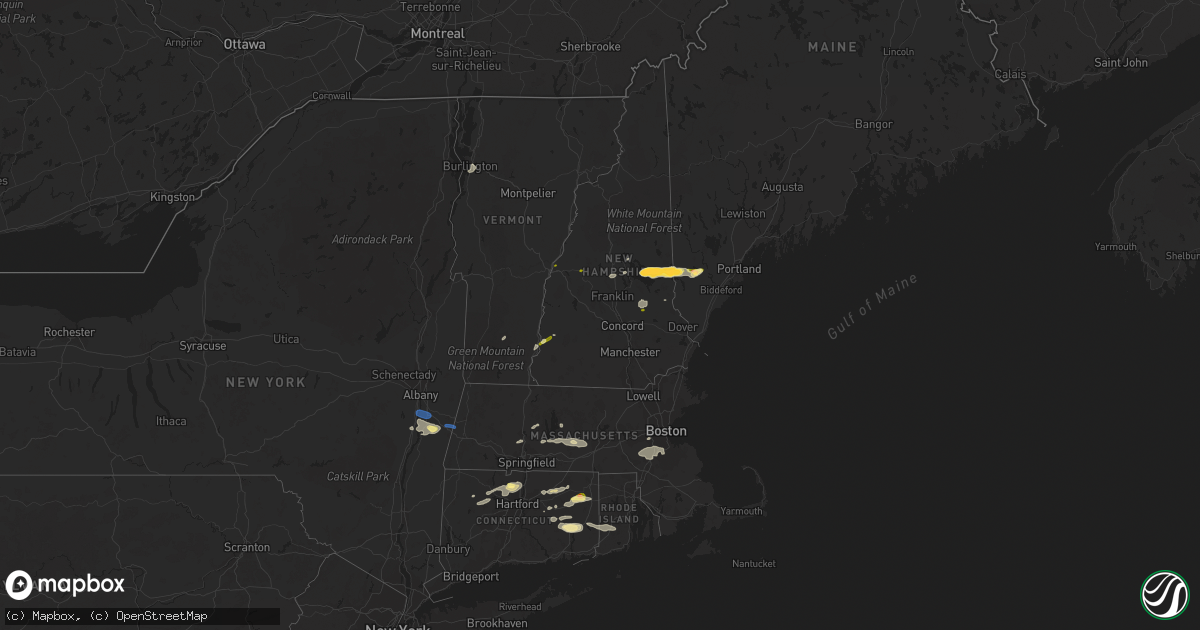
Hail Map in New Hampshire on August 26, 2022
Get this storm
August 26 map
$229
one time, instant access
Download today. No call, no setup
Keep the $229
Bought the map and want the full workflow? Apply the entire $229 to a subscription within 7 days. None of it is wasted.
Every map, not just this one
This buys you this map. Subscription and you get every map we run, in the markets you choose from a few cities to whole states to nationwide. Plus real-time alerts the moment a storm fires.
Contact data
Name, contact info, occupancy, even credit band for addresses in the footprint. You go from where it hit to who to call.
Become the source they trust
Unlimited branding weather history reports on demand. You already have the documented answer ready for the property owner, and you are the one who showed up with it.
Property data and RoofTrace estimates
Pull up any address you have got, its value and the exact code rules for that jurisdiction, straight from One Click Code. Then RoofTrace estimates the squares, pitch, and roof value, priced the way you price.
Storm reports in New Hampshire
New Hampshire
| Date | Description |
|---|---|
| 08/26/20222:32 PM CDT | Reported by weather spotter: st144 reported trees and branches down and blocking merrymeeting rd. Time estimated by radar. |
| 08/26/20222:32 PM CDT | Observed 1.25 inch hail in barnstead. Time estimated by radar. |
| 08/26/20222:20 PM CDT | Delayed report. Multiple trees reported down off rt 107 near sawyer lake rd. Time estimated from radar. |
| 08/26/20222:16 PM CDT | Reported by weather spotter: golfball-size hail currently falling on e. Wakefield. Hail accumulating in places. Time estimated by radar. |
| 08/26/20222:15 PM CDT | 1.75 inch measured hail north of wolfeboro and lake wentworth on highway 28. Dented vehicle hood. Time estimated by radar. |
| 08/26/20221:48 PM CDT | Reported by amateur radio: social media photo showing two-inch hail near mirror lake. Time estimated by radar. |
| 08/26/20221:34 PM CDT | Tree reported down on rt. 101 near oliver rd. |
| 08/26/20221:34 PM CDT | Reported by weather spotter: large branches and two trees down on rte 123 west of marlow. |
| 08/26/20221:30 PM CDT | Tree and wires down. Time estimated by radar. |
| 08/26/20221:28 PM CDT | Spotter me87 reported trees down in sunapee. |
| 08/26/20221:17 PM CDT | Multiple trees down in newport off of unity springs rd. Time estimated from radar. |
| 08/26/20221:10 PM CDT | Reported by amateur radio: report of half dollar sized hail damaging a vehicle on homestead road south of alstead. Time estimated by radar. |
| 08/26/20221:08 PM CDT | Tree and wires down. Time estimated by radar. |
| 08/26/20221:00 PM CDT | Delayed report. Social media reports of trees down across walpole along with hail. Relayed by amateur radio. Time estimated from radar. |
| 08/26/202212:58 PM CDT | Tree down on bowen crossing rd. |
| 08/26/202212:55 PM CDT | Delayed report. Measured hail between ping pong and golfball-sized just south of walpole on nh 12. Appeared to damage crops. Time estimated by radar. |
| 08/26/202212:28 PM CDT | Tree reported down on wires off of ranch rd. Time approximated from radar. |
| 08/26/202212:24 PM CDT | Corrects previous hail report from canaan. Hail of at least quarter size fell for approximately 4 minutes. |
| 08/26/202212:13 PM CDT | Numerous branches and a few trees reported down on canaan st. Time estimated by radar. |
| 08/26/202212:13 PM CDT | Hail of at least quarter size fell for approximately 4 minutes. |
| 08/26/202212:02 PM CDT | Reported by weather spotter. A few trees and branches down on may st and other streets on east side of lebanon. Largest diameter tree was 6 inches. Time estimated by ra |
| 08/26/202211:52 AM CDT | Delayed report: large branches scattered across high road. Time estimated by radar. |
| 08/25/202210:12 PM CDT | At 311 PM EDT, a severe thunderstorm was located near Ossipee, moving east at 25 mph. HAZARD...Ping pong ball size hail and 60 mph wind gusts. SOURCE...Radar indicated. IMPACT...People and animals outdoors will be injured. Expect hail damage to roofs, siding, windows, and vehicles. Expect wind damage to roofs, siding, and trees. Locations impacted include... Alfred, Buxton, Hollis, Cornish, Waterboro, Standish, Lyman, Limington, Limerick, Acton, Parsonsfield, Newfield, Shapleigh and Dayton. |
| 08/25/20229:49 PM CDT | At 248 PM EDT, a severe thunderstorm was located near Wolfeboro, or near Ossipee, moving east at 20 mph. HAZARD...60 mph wind gusts and half dollar size hail. SOURCE...Radar indicated. IMPACT...Hail damage to vehicles is expected. Expect wind damage to roofs, siding, and trees. Locations impacted include... Ossipee, Moultonborough, Alton, Effingham, Wolfeboro, Gilford, Acton, Brookfield, Wakefield, Tuftonboro, Newfield and New Durham. |
| 08/25/20229:29 PM CDT | At 229 PM EDT, a severe thunderstorm was located over Gilsum, or near Keene, moving northeast at 40 mph. HAZARD...60 mph wind gusts and quarter size hail. SOURCE...Radar indicated. IMPACT...Hail damage to vehicles is expected. Expect wind damage to roofs, siding, and trees. Locations impacted include... Keene, Jaffrey, Henniker, Peterborough, Antrim, Greenfield, Lyndeborough, Bradford, Dublin, Francestown, Bennington, Richmond, Harrisville, Nelson, Marlborough, Gilsum, Windsor, Hancock, Deering and Hillsborough. |
| 08/25/20229:27 PM CDT | At 227 PM EDT, severe thunderstorms were located along a line extending from 6 miles northeast of Claremont to near New London to Bradford, moving northeast at 60 mph. HAZARD...60 mph wind gusts and nickel size hail. SOURCE...Radar indicated. IMPACT...Expect damage to roofs, siding, and trees. Locations impacted include... Claremont, Franklin, New London, Plymouth, Meredith, Grafton, Enfield, Canaan, Holderness, Ashland, Bradford, Danbury, Groton, Warner, Newport, Belmont, Boscawen, Bristol, Grantham and Andover.This includes the following highways... Interstate 89 between mile markers 20 and 50. Interstate 93 between mile markers 55 and 80. |
| 08/25/20229:12 PM CDT | At 211 PM EDT, a severe thunderstorm was located near Ashland, or near Meredith, moving east at 20 mph. HAZARD...60 mph wind gusts and quarter size hail. SOURCE...Radar indicated. IMPACT...Hail damage to vehicles is expected. Expect wind damage to roofs, siding, and trees. Locations impacted include... Laconia, Meredith, Moultonborough, Holderness, Ashland, Sandwich, Wolfeboro, Tamworth, Gilford, Center Harber, New Hampton, Tuftonboro and Sanbornton.This includes Interstate 93 between mile markers 65 and 74. |
| 08/25/20228:52 PM CDT | At 152 PM EDT, severe thunderstorms were located along a line extending from 12 miles northwest of Charlestown to near Westmoreland to 12 miles west of Chesterfield, moving east at 25 mph. HAZARD...60 mph wind gusts and quarter size hail. SOURCE...Radar indicated. IMPACT...Hail damage to vehicles is expected. Expect wind damage to roofs, siding, and trees. Locations impacted include... Keene, Claremont, Charlestown, Nelson, Newport, Gilsum, Marlow, Walpole, Sullivan, Alstead, Westmoreland, Surry, Grantham, Cornish, Lempster, Acworth, Goshen, Croydon, Langdon and Washington.This includes Interstate 89 mile marker 43 and near mile marker 45. |
| 08/25/20228:38 PM CDT | At 135 PM EDT, a severe thunderstorm was located over mainly rural areas of Northern Windham County, moving east at 40 mph. HAZARD...60 mph wind gusts and quarter size hail. SOURCE...Radar indicated. IMPACT...Hail damage to vehicles is expected. Expect wind damage to roofs, siding, and trees. Locations impacted include... Bellows Falls, Londonderry, Townshend, Putney, Saxtons River, Westminster, Newfane, West Wardsboro, Windham, Rockingham, Jamaica, Wardsboro, Grafton, Brookline, Athens, North Westminster, Wardsboro Center, Goose City, East Putney and Brockways Mills. |
| 08/25/20228:24 PM CDT | At 123 PM EDT, severe thunderstorms were located along a line extending from 10 miles southeast of Piermont to Canaan, moving east at 25 mph. HAZARD...60 mph wind gusts and nickel size hail. SOURCE...Radar indicated. IMPACT...Expect damage to roofs, siding, and trees. Locations impacted include... Lincoln, Plymouth, Meredith, Moultonborough, Grafton, Enfield, Canaan, Holderness, Ashland, Groton, Woodstock, Sandwich, Bristol, Center Harber, Hebron, Benton, Dorchester, Ellsworth, Orange and Thornton.This includes Interstate 93 between mile markers 68 and 102. |
All States Impacted by Hail Map on August 26, 2022
Cities Impacted by Hail Map on August 26, 2022
- Prestonsburg, KY
- Pikeville, KY
- Stanville, KY
- Flaxville, MT
- Milesville, SD
- Lakeside, MT
- Plentywood, MT
- Duchesne, UT
- Downey, ID
- Beattyville, KY
- Froid, MT
- Hudson, NY
- Chatham, NY
- Schodack Landing, NY
- Ghent, NY
- Valatie, NY
- Old Chatham, NY
- Stuyvesant, NY
- Coxsackie, NY
- West Coxsackie, NY
- East Chatham, NY
- Kinderhook, NY
- Stuyvesant Falls, NY
- Spartanburg, SC
- Redstone, MT
- Columbia, TN
- Kenna, WV
- Gandeeville, WV
- Sandyville, WV
- Reedy, WV
- Gay, WV
- Le Roy, WV
- Jamaica, VT
- Onamia, MN
- Hillman, MN
- Pierz, MN
- Grenora, ND
- Williston, ND
- Nashua, MT
- Moultonborough, NH
- Center Harbor, NH
- Heber, AZ
- Show Low, AZ
- Belchertown, MA
- Windsor, CT
- Bloomfield, CT
- East Granby, CT
- Simsbury, CT
- Tariffville, CT
- Saint Onge, SD
- Vale, SD
- Aladdin, WY
- Sundance, WY
- Union Center, SD
- Spearfish, SD
- New Underwood, SD
- Belle Fourche, SD
- Whitewood, SD
- Beulah, WY
- Newell, SD
- Alva, WY
- Sturgis, SD
- Nisland, SD
- Wolfeboro, NH
- Center Tuftonboro, NH
- Mirror Lake, NH
- Lebanon, TN
- Metropolis, IL
- Oak Park, MN
- Needham, MA
- Wellesley Hills, MA
- Needham Heights, MA
- Lebanon, CT
- Baltic, CT
- North Franklin, CT
- Cleveland, MN
- Madison Lake, MN
- Taylor, AZ
- Snowflake, AZ
- North Brookfield, MA
- South Burlington, VT
- Shelburne, VT
- Burlington, VT
- Montgomery, MN
- Lonsdale, MN
- Clear Lake, MN
- Bainville, MT
- Mora, MN
- Hays, MT
- Hulett, WY
- Park Rapids, MN
- Menahga, MN
- Custer, SD
- Ekalaka, MT
- Rozet, WY
- Gillette, WY
- Weston, WY
- Devils Tower, WY
- Moorcroft, WY
- Fort Pierre, SD
- Westby, MT
- Wyola, MT
- Aitkin, MN
- Climax, NY
- Malta, MT
- Meredith, NH
- Sanbornville, NH
- East Wakefield, NH
- Dodson, MT
- Philip, SD
- Lindstrom, MN
- Center City, MN
- Chapel Hill, TN
- Lewisburg, TN
- Fenelton, PA
- Cabot, PA
- Butler, PA
- Ware, MA
- New Braintree, MA
- Spencer, MA
- East Brookfield, MA
- Leicester, MA
- West Brookfield, MA
- Brockton, MT
- New Hampton, NH
- Fair Play, SC
- Westminster, SC
- Hampton, CT
- Pomfret Center, CT
- Mansfield Center, CT
- Danielson, CT
- Brooklyn, CT
- Chaplin, CT
- North Windham, CT
- Alzada, MT
- Decker, MT
- Chester, ID
- Ashton, ID
- Allen, SD
- Wanblee, SD
- Amherst, MA
- Winona, MN
- Antelope, MT
- Hayes, SD
- Hermosa, SD
- Keystone, SD
- Rapid City, SD
- West Kingston, RI
- Hope Valley, RI
- Voluntown, CT
- Exeter, RI
- Rockville, RI
- Jewett City, CT
- Wyoming, RI
- Fort Scott, KS
- Putney, VT
- Easthampton, MA
- Holyoke, MA
- Foreston, MN
- East Waterboro, ME
- Waterboro, ME
- Ossipee, NH
- Hollis Center, ME
- North Waterboro, ME
- West Newfield, ME
- Acton, ME
- Limerick, ME
- Shapleigh, ME
- Spring Hill, TN
- Whitetail, MT
- Lower Brule, SD
- Farmington, NH
- Raton, NM
- Gann Valley, SD
- Frazer, MT
- Weatogue, CT
- Windsor Locks, CT
- West Simsbury, CT
- Canton, CT
- New Hartford, CT
- Granby, CT
- Eastford, CT
- Ashford, CT
- Willington, CT
- Tolland, CT
- Faribault, MN
- Kilkenny, MN
- Buckhorn, KY
- Booneville, KY
- College Grove, TN
- Arrington, TN
- Nolensville, TN
- Alstead, NH
- Fort Thompson, SD
- Foley, MN
- Center Barnstead, NH
- Gilmanton Iron Works, NH
- Barnstead, NH
- Gilmanton, NH
- Needles, CA
- Hagerhill, KY
- East Point, KY
- Torrington, CT
- Bozrah, CT
- Taftville, CT
- Norwich, CT
- Preston, CT
- Yantic, CT
- Walpole, NH
- Flagstaff, AZ
- Hardwick, MA
- Burlington, CT
- Litchfield, CT
- Harwinton, CT
- Maxwell, NM
- Medicine Lake, MT
- Wolf Point, MT
- Wessington Springs, SD
- Dagmar, MT
- Soda Springs, ID
- Hinsdale, MT
- Opheim, MT
- Sanbornton, NH
- River Falls, WI
- Hastings, MN
- Princeton, MN
- Columbia, CT
- Andover, CT
- Gilman, CT
- Spencer, WV
- Medfield, MA
- Milton, MA
- Randolph, MA
- Norwood, MA
- Norfolk, MA
- Millis, MA
- Walpole, MA
- Dover, MA
- East Walpole, MA
- Dedham, MA
- Canton, MA
- Westwood, MA
- Sharon, MA
- Parsonsfield, ME
- Maple Lake, MN
- Annandale, MN
- Coventry, CT
- Becker, MN
- Monticello, MN
- Clearwater, MN
- Greer, SC
- Greenville, SC
- Pomeroy, OH
- Long Bottom, OH
- Interior, SD
- Hebron, CT
- Northfield, MN
- Selkirk, NY
- Ravena, NY
- Castleton On Hudson, NY
- Nassau, NY
- Canaan, NY
- Richmond, MA
- Pittsfield, MA
- Canaan, NH
- Pittsfield, NH
- Beach, ND
- Leupp, AZ
- White Owl, SD
- Howes, SD
- Enning, SD
- Scenic, SD
- Kyle, SD
- Kadoka, SD
- Pine Ridge, SD
- Quinn, SD
- Caputa, SD
- Wall, SD
- Midland, SD


