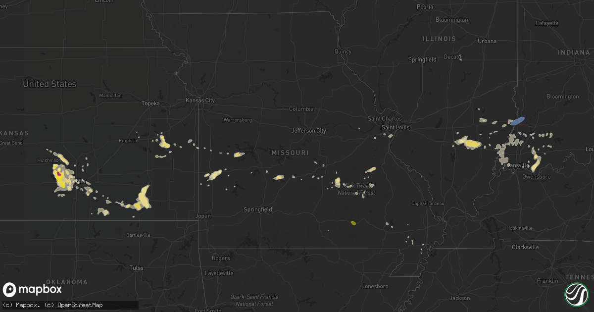
Hail Map in Missouri on August 21, 2019
Get this storm
August 21 map
$229
one time, instant access
Download today. No call, no setup
Keep the $229
Bought the map and want the full workflow? Apply the entire $229 to a subscription within 7 days. None of it is wasted.
Every map, not just this one
This buys you this map. Subscription and you get every map we run, in the markets you choose from a few cities to whole states to nationwide. Plus real-time alerts the moment a storm fires.
Contact data
Name, contact info, occupancy, even credit band for addresses in the footprint. You go from where it hit to who to call.
Become the source they trust
Unlimited branding weather history reports on demand. You already have the documented answer ready for the property owner, and you are the one who showed up with it.
Property data and RoofTrace estimates
Pull up any address you have got, its value and the exact code rules for that jurisdiction, straight from One Click Code. Then RoofTrace estimates the squares, pitch, and roof value, priced the way you price.
Storm reports in Missouri
Missouri
| Date | Description |
|---|---|
| 08/21/20193:25 PM CDT | Quarter size hail mixed in with a lot of pea to half inch sized hail. |
| 08/21/20194:23 AM CDT | At 923 PM CDT, a severe thunderstorm was located near Walker, or near El Dorado Springs, moving northeast at 15 mph. HAZARD...60 mph wind gusts and quarter size hail. SOURCE...Radar indicated. IMPACT...Hail damage to vehicles is expected. Expect wind damage to roofs, siding, and trees. Locations impacted include... El Dorado Springs... Osceola... Walker... Schell City... Roscoe... Harwood... Tiffin... Taberville... Cedar Springs... Monegaw Springs... |
| 08/21/20192:51 AM CDT | At 750 PM CDT, a severe thunderstorm was located 8 miles northwest of Lebanon, moving northeast at 15 mph. HAZARD...60 mph wind gusts and quarter size hail. SOURCE...Radar indicated. IMPACT...Hail damage to vehicles is expected. Expect wind damage to roofs, siding, and trees. Locations impacted include... Lebanon... Bennett Spring State Park... Stoutland... Bennett Springs... Windyville... Eldridge... Decaturville... Plad... Sleeper... Montreal...This includes Interstate 44 between mile markers 132 and 141. |
| 08/21/20192:36 AM CDT | At 736 PM CDT, a severe thunderstorm was located near Salem, moving east at 5 mph. HAZARD...60 mph wind gusts and quarter size hail. SOURCE...Radar indicated. IMPACT...Hail damage to vehicles is expected. Expect wind damage to roofs, siding, and trees. Locations impacted include... Howes... Sligo... |
| 08/21/20192:10 AM CDT | At 709 AM CDT, a severe thunderstorm was located over Alma, or near Concordia, moving east at 20 mph. HAZARD...60 mph wind gusts and quarter size hail. SOURCE...Radar indicated. IMPACT...Hail damage to vehicles is expected. Expect wind damage to roofs, siding, and trees. Locations impacted include... Concordia, Sweet Springs, Waverly, Corder, Alma, Malta Bend, Blackburn, Emma, Aullville, Mount Leonard and Grand Pass.This includes Interstate 70 in Missouri between mile markers 53 and74. |
| 08/21/20191:02 AM CDT | At 601 AM CDT, a severe thunderstorm was located over Chillicothe, moving east at 25 mph. HAZARD...60 mph wind gusts and nickel size hail. SOURCE...Radar indicated. IMPACT...Expect damage to roofs, siding, and trees. Locations impacted include... Chillicothe, Brookfield, Meadville, Laclede, Linneus, Wheeling, Utica, Chula, Purdin, Mendon, Sumner, Rothville, Spring Hill, Avalon and Dawn. |
| 08/21/201912:19 AM CDT | At 519 AM CDT, a severe thunderstorm was located near Hamilton, moving east at 15 mph. HAZARD...60 mph wind gusts and quarter size hail. SOURCE...Radar indicated. IMPACT...Hail damage to vehicles is expected. Expect wind damage to roofs, siding, and trees. Locations impacted include... Chillicothe, Hamilton, Gallatin, Jamesport, Breckenridge, Kingston, Utica, Altamont, Ludlow, Mooresville, Lock Springs, Spring Hill and Dawn. |
| 08/20/201911:05 PM CDT | At 405 PM CDT, a severe thunderstorm was located over Grassy, or 10 miles west of Marble Hill, moving southeast at 10 mph. HAZARD...60 mph wind gusts and quarter size hail. SOURCE...Radar indicated. IMPACT...Hail damage to vehicles is expected. Expect wind damage to roofs, siding, and trees. Locations impacted include... Marble Hill, Cascade, Grassy, Zalma and Glenallen. |
| 08/20/20199:58 PM CDT | At 258 PM CDT, a severe thunderstorm was located over Fremont, or 9 miles southwest of Van Buren, moving southeast at 10 mph. HAZARD...60 mph wind gusts and quarter size hail. SOURCE...Radar indicated. IMPACT...Hail damage to vehicles is expected. Expect wind damage to roofs, siding, and trees. Locations impacted include... Fremont. |
| 08/20/20198:55 PM CDT | At 154 PM CDT, a severe thunderstorm was located over Dodd City, or 11 miles northwest of Yellville, moving northeast at 10 mph. HAZARD...60 mph wind gusts and quarter size hail. SOURCE...Radar indicated. IMPACT...Hail damage to vehicles is expected. Expect wind damage to roofs, siding, and trees. Locations impacted include... Bull Shoals... Lakeview in Baxter County... Arkawana... Dodd City... Price Place... Ozark Isle... Lakeway... Bull Shoals State Park... Clark Hill... Clarkridge... Monarch... Oakland... Peel... Three Brothers... Bull Shoals Lake... Norfork Lake... |
| 08/20/20198:53 PM CDT | Delayed report. Numerous 6-8 inch limbs down throughout chesterfield and clarkson valley between i-64 and wilson road. Time estimated from radar. |
| 08/20/20197:43 PM CDT | Tree limbs down. |
All States Impacted by Hail Map on August 21, 2019
Cities Impacted by Hail Map on August 21, 2019
- Albion, IL
- Augusta, KS
- Andover, KS
- Casper, WY
- Sedan, KS
- Longton, KS
- Morrison, CO
- Denver, CO
- Williamsburg, KS
- Yoder, WY
- Hawk Springs, WY
- Littleton, CO
- Chesterfield, MO
- Ballwin, MO
- Tennyson, IN
- Gentryville, IN
- Richland, IN
- Chrisney, IN
- Rockport, IN
- Portageville, MO
- Trafford, AL
- Warrior, AL
- Matheson, CO
- Belleview, MO
- Belgrade, MO
- Benedict, KS
- Elk City, KS
- Independence, KS
- Neodesha, KS
- Fredonia, KS
- Texhoma, OK
- Kenton, OK
- Boise City, OK
- Mount Hope, KS
- Chugwater, WY
- Cambridge, KS
- Loogootee, IN
- Jasper, IN
- Dubois, IN
- Peace Valley, MO
- Goddard, KS
- Colwich, KS
- Garden Plain, KS
- Andale, KS
- Wichita, KS
- Cheney, KS
- Haven, KS
- Viola, KS
- Moundville, MO
- Nevada, MO
- Goodwell, OK
- Princeton, IN
- Patoka, IN
- Burrton, KS
- Black Eagle, MT
- Cascade, MT
- Great Falls, MT
- Milo, MO
- Walker, MO
- Worland, WY
- Bluford, IL
- Dale, IN
- Whitewater, KS
- Aurora, CO
- Agate, CO
- Halstead, KS
- Garnett, KS
- Greeley, KS
- Richmond, KS
- Princeton, KS
- Conway Springs, KS
- Floral, AR
- Newton, KS
- Noble, IL
- Harwood, MO
- El Dorado Springs, MO
- Inman, KS
- Rocky Ford, CO
- Wayne City, IL
- Keenes, IL
- Mount Vernon, IL
- Fairfield, IL
- Sims, IL
- Rock, KS
- Doswell, VA
- Liberal, KS
- Hugoton, KS
- Thermopolis, WY
- Kirby, WY
- Salem, MO
- Niotaze, KS
- Peru, KS
- Clearwater, KS
- Maize, KS
- Lebanon, MO
- Eldridge, MO
- Kaycee, WY
- La Cygne, KS
- Arkansas City, KS
- Garden City, KS
- Holcomb, KS
- Sedgwick, KS
- Valley Center, KS
- Marthasville, MO
- Windyville, MO
- Rolla, MO
- Power, MT
- Dexter, MO
- Fenton, MO
- Douglass, KS
- Golden, CO
- Stockton, MO
- Argenta, IL
- Derby, KS
- Waverly, KS
- Hutchinson, KS
- Dexter, KS
- Holland, IN
- Moline, KS
- Floweree, MT
- Deepwater, MO
- Osceola, MO
- Lowry City, MO
- Guymon, OK
- Richland, MO
- Turpin, OK
- Simla, CO
- Ramah, CO
- Calhan, CO
- Westphalia, KS
- Bentley, KS
- Milton, KS
- Norwich, KS
- Haysville, KS
- Poseyville, IN
- Liberal, MO
- Stoutland, MO
- Caledonia, MO
- Rector, AR
- Welda, KS
- Colony, KS
- Mount Vernon, IN
- Evansville, IN
- Pleasanton, KS
- Amoret, MO
- Udall, KS
- Pomona, KS
- Quenemo, KS
- Bigelow, AR
- Otwell, IN
- Potosi, MO
- Mineral Point, MO
- Owensboro, KY
- Grenola, KS
- Paragould, AR
- Harrisburg, NE
- Lyman, NE
- Buhler, KS
- Moundridge, KS
- Cannelburg, IN
- Butler, MO
- Ellery, IL
- Shoals, IN
- French Lick, IN
- Bunker, MO
- Bloomfield, MO
- Dix, NE
- Urbana, MO
- Jerico Springs, MO
- Lockwood, MO
- Boss, MO
- Buffalo, WY
- Yuma, CO
- Le Roy, KS
- Garrett, WY
- West Salem, IL
- Hazleton, IN
- Vincennes, IN
- Owensville, IN
- Allendale, IL
- New Harmony, IN
- Wadesville, IN
- Grayville, IL
- Mount Carmel, IL
- Decker, IN
- Griffin, IN
- Petersburg, IN
- Meriden, WY
- Malden, MO
- Newburg, MO
- Edgar Springs, MO
- Rose Hill, KS
- Walsenburg, CO
- Lawrenceville, IL
- Bridgeport, IL
- Bushnell, NE
- East Earl, PA
- Iuka, IL
- Francisco, IN
- Parma, MO
- Williamsville, MO
- Ironton, MO
- Middle Brook, MO
- Lesterville, MO
- Saint James, MO
- Forgan, OK
- Atlanta, KS
- Lilbourn, MO
- Ferdinand, IN
- Newburgh, IN
- Englewood, CO
- Appleton City, MO
- Black, MO
- Owensville, MO
- Dahlgren, IL
- Barnhill, IL
- Johnsonville, IL
- Winslow, IN
- Kit Carson, CO
- Dixon, MO
- Wheat Ridge, CO
- Conrad, MT
- Bono, AR
- Fontana, KS
- Claremont, IL
- Olney, IL
- Bronaugh, MO
- Sheldon, MO
- Boonville, IN
- Holyoke, CO
- Reading, KS
- Knobel, AR
- Dieterich, IL
- Lincoln City, IN
- Stendal, IN
- Oakland City, IN
- Santa Claus, IN
- Huntingburg, IN
- Birdseye, IN
- Saint Anthony, IN
- Lovington, IL
- Houston, AR
- Golden Gate, IL
- Fairfield, MT
- Sumner, IL
- Deer Trail, CO
- Poplar Bluff, MO
- Benton, KS
- Ingraham, IL
- Clay City, IL
- Rush, CO
- Lamar, MO
- Fort Leonard Wood, MO
- Centerville, MO
- Eureka, MO
- Pacific, MO
- Cisne, IL
- Cedar Vale, KS
- Burden, KS
- Winfield, KS
- Piggott, AR
- Wheatland, WY
- Parker, KS
- Flemington, MO
- Sedalia, CO
- Saint Louis, MO
- Fremont, MO
- Lysite, WY
- Shoshoni, WY
- Medicine Bow, WY
- Round Lake, NY
- Ballston Lake, NY
- Ballston Spa, NY
- Mechanicville, NY
- Troy, NY
- Latham, NY
- Albany, NY
- Waterford, NY
- Cohoes, NY
- Watervliet, NY
- Tyngsboro, MA
- Pelham, NH
- Hudson, NH
- Nashua, NH
- Andover, CT
- Columbia, CT
- Glastonbury, CT
- Bolton, CT
- Coventry, CT
- Manchester, CT
- Mansfield Center, CT
- Storrs Mansfield, CT
- Hebron, CT
- East Hartford, CT
- Union Mills, NC
- Marion, NC
- Bostic, NC
- Stony Point, NC
- Catawba, NC
- Conover, NC
- Claremont, NC
- Taylorsville, NC
- Hickory, NC
- Statesville, NC
- Oaktown, IN
- Saint Francisville, IL
- Bruceville, IN
- Bicknell, IN
- Oktaha, OK
- Checotah, OK
- Catoosa, OK
- Tulsa, OK
- Colorado Springs, CO
- Cotopaxi, CO
- Granite Falls, NC
- College Park, MD
- Bowie, MD
- Hyattsville, MD
- Lanham, MD
- Silver Spring, MD
- Harwood, MD
- Upper Marlboro, MD
- Bladensburg, MD
- Glenn Dale, MD
- Takoma Park, MD
- Greenbelt, MD
- Riverdale, MD
- Saratoga Springs, NY
- Schuylerville, NY
- Wethersfield, CT
- Canterbury, CT
- Brooklyn, CT
- Danielson, CT
- Dayville, CT
- Chaplin, CT
- North Windham, CT
- Foster, RI
- Hampton, CT
- Narvon, PA
- Mohnton, PA
- Morgantown, PA
- Douglassville, PA
- Elverson, PA
- Birdsboro, PA


