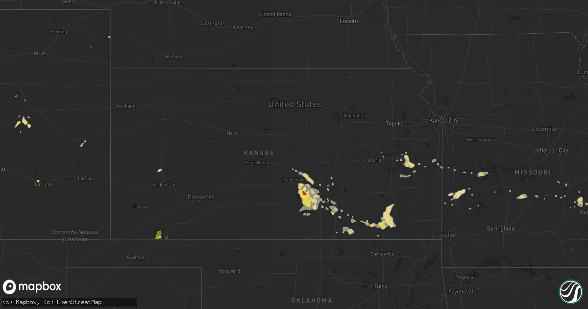
Hail Map in Kansas on August 21, 2019
Get this storm
August 21 map
$229
one time, instant access
Download today. No call, no setup
Keep the $229
Bought the map and want the full workflow? Apply the entire $229 to a subscription within 7 days. None of it is wasted.
Every map, not just this one
This buys you this map. Subscription and you get every map we run, in the markets you choose from a few cities to whole states to nationwide. Plus real-time alerts the moment a storm fires.
Contact data
Name, contact info, occupancy, even credit band for addresses in the footprint. You go from where it hit to who to call.
Become the source they trust
Unlimited branding weather history reports on demand. You already have the documented answer ready for the property owner, and you are the one who showed up with it.
Property data and RoofTrace estimates
Pull up any address you have got, its value and the exact code rules for that jurisdiction, straight from One Click Code. Then RoofTrace estimates the squares, pitch, and roof value, priced the way you price.
Storm reports in Kansas
Kansas
| Date | Description |
|---|---|
| 08/21/20196:55 PM CDT | Estimated 60 to 70 mph winds in buhler. |
| 08/21/20196:35 PM CDT | Spotter estimated wind speeds approaching 60 mph at his location. Hail was also occurring... But size is unknown since the spotter was driving at the time. |
| 08/21/20195:45 PM CDT | Electrical line blown down. |
| 08/21/20196:02 AM CDT | At 1102 PM CDT, a severe thunderstorm was located near Elk City, or 8 miles west of Independence, moving east at 35 mph. HAZARD...60 mph wind gusts and half dollar size hail. SOURCE...Radar indicated. IMPACT...Hail damage to vehicles is expected. Expect wind damage to roofs, siding, and trees. Locations impacted include... Parsons, Coffeyville, Independence, Neodesha, Fredonia, Cherryvale, Caney, Oswego, Erie, Chetopa, Altamont, St. Paul, Thayer, Edna, Dearing, Altoona, Mound Valley, Elk City, Tyro and Galesburg. |
| 08/21/20195:01 AM CDT | At 1000 PM CDT, a severe thunderstorm was located over Andale, or near Mount Hope, moving east at 15 mph. HAZARD...60 mph wind gusts and half dollar size hail. SOURCE...Radar indicated. IMPACT...Hail damage to vehicles is expected. Expect wind damage to roofs, siding, and trees. Locations impacted include... Wichita, Park City, Valley Center, Maize, Sedgwick, Colwich, Mount Hope, Andale and Bentley.This includes Interstate 135 between Mile Markers 8 and 22. |
| 08/21/20193:55 AM CDT | At 855 PM CDT, severe thunderstorms were located along a line extending from near Towanda to 5 miles northeast of Douglass to 5 miles north of Udall to 5 miles northwest of Belle Plaine, moving southeast at 30 mph. HAZARD...70 mph wind gusts and half dollar size hail. SOURCE...Radar indicated. IMPACT...Hail damage to vehicles is expected. Expect considerable tree damage. Wind damage is also likely to mobile homes, roofs, and outbuildings. Locations impacted include... Derby, El Dorado, Winfield, Andover, Haysville, Augusta, Mulvane, Rose Hill, Clearwater, Douglass, Belle Plaine, Towanda, Oxford, Benton, Udall, Leon, Burden, Dexter, Atlanta and Latham.This includes Interstate 35 between Mile Markers 24 and 41, andbetween Mile Markers 56 and 74. |
| 08/21/20193:32 AM CDT | At 832 PM CDT, a severe thunderstorm was located near Severy, or 8 miles north of Howard, moving northeast at 10 mph. HAZARD...60 mph wind gusts and quarter size hail. SOURCE...Radar indicated. IMPACT...Hail damage to vehicles is expected. Expect wind damage to roofs, siding, and trees. Locations impacted include... Severy, Fall River, Climax, Piedmont, Fall River Lake and Fall River State Park. |
| 08/21/20193:04 AM CDT | At 803 PM CDT, a severe thunderstorm was located near Garnett, moving east-southeast at 20 mph. HAZARD...60 mph wind gusts and quarter size hail. SOURCE...Radar indicated. IMPACT...Hail damage to vehicles is expected. Expect wind damage to roofs, siding, and trees. Locations impacted include... Parker. |
| 08/21/20192:56 AM CDT | At 756 PM CDT, severe thunderstorms were located along a line extending from 5 miles southwest of Burns to near Viola, moving southeast at 25 mph. HAZARD...70 mph wind gusts and half dollar size hail. SOURCE...Public. IMPACT...Hail damage to vehicles is expected. Expect considerable tree damage. Wind damage is also likely to mobile homes, roofs, and outbuildings. Locations impacted include... Wichita, Derby, Newton, El Dorado, Andover, Haysville, Augusta, Wellington, Park City, Valley Center, Bel Aire, Mulvane, Goddard, Rose Hill, Maize, Clearwater, Douglass, Sedgwick, Belle Plaine and Towanda.This includes the following highways... Interstate 135 between Mile Markers 0 and 33. Interstate 35 between Mile Markers 5 and 95. |
| 08/21/20192:43 AM CDT | At 743 PM CDT, a severe thunderstorm was located over Linn Valley, or near La Cygne, moving southeast at 15 mph. HAZARD...60 mph wind gusts and quarter size hail. SOURCE...Radar indicated. IMPACT...Hail damage to vehicles is expected. Expect wind damage to roofs, siding, and trees. Locations impacted include... La Cygne, Linn Valley, Amsterdam, Amoret, Foster, Merwin and Worland. |
| 08/21/20192:43 AM CDT | At 742 PM CDT, a severe thunderstorm was located 4 miles west-northwest of Garnett, moving east-southeast at 15 mph. HAZARD...60 mph wind gusts and half dollar size hail. SOURCE...Radar indicated. IMPACT...Hail damage to vehicles is expected. Expect wind damage to roofs, siding, and trees. Locations impacted include... Garnett and Greeley. |
| 08/21/20192:20 AM CDT | At 720 PM CDT, a severe thunderstorm was located 6 miles northwest of Halstead, moving southeast at 20 mph. HAZARD...70 mph wind gusts and ping pong ball size hail. SOURCE...Radar indicated. IMPACT...People and animals outdoors will be injured. Expect hail damage to roofs, siding, windows, and vehicles. Expect considerable tree damage. Wind damage is also likely to mobile homes, roofs, and outbuildings. Locations impacted include... Newton, Hesston, Halstead, North Newton, Burrton, Whitewater, Walton and Newton Airport.This includes Interstate 135 between Mile Markers 25 and 42. |
| 08/21/20191:56 AM CDT | At 656 PM CDT, a severe thunderstorm was located over Haven, moving southeast at 25 mph. HAZARD...Ping pong ball size hail and 60 mph wind gusts. SOURCE...Radar indicated. IMPACT...People and animals outdoors will be injured. Expect hail damage to roofs, siding, windows, and vehicles. Expect wind damage to roofs, siding, and trees. Locations impacted include... Wichita, Park City, Valley Center, Goddard, Maize, Sedgwick, Colwich, Haven, Burrton, Mount Hope, Kechi, Andale, Bentley, West Wichita, Eisenhower National Airport, Yoder and Lake Afton.This includes Interstate 135 between Mile Markers 11 and 24. |
| 08/21/20191:37 AM CDT | At 637 PM CDT, a severe thunderstorm was located 6 miles east of Eva, or 14 miles southeast of Elkhart, moving northeast at 5 mph. HAZARD...60 mph wind gusts and quarter size hail. SOURCE...Radar indicated. IMPACT...Minor damage to roofs, siding, and trees is possible. Hail damage to vehicles is expected. Locations impacted include... Guymon, Hooker, Goodwell, Texhoma, Tyrone, Optima, Keyes, Hardesty, Hough, Adams, Griggs, Eva and Sturgis. |
| 08/21/20191:30 AM CDT | At 630 PM CDT, a severe thunderstorm was located 6 miles west of Inman, moving east at 15 mph. HAZARD...60 mph wind gusts and penny size hail. SOURCE...Radar indicated. IMPACT...Expect damage to roofs, siding, and trees. Locations impacted include... Mcpherson, Moundridge, Inman, Buhler and Mcpherson Airport. This includes Interstate 135 between Mile Markers 49 and 60. |
| 08/21/20191:29 AM CDT | At 628 PM CDT, a severe thunderstorm was located 6 miles west of Inman, moving east at 15 mph. This is a very dangerous storm. HAZARD...100 mph wind gusts. SOURCE...Radar indicated. IMPACT...You are in a life-threatening situation. Flying debris may be deadly to those caught without shelter. Mobile homes will be destroyed. Expect considerable damage to homes and businesses. Expect extensive tree damage and power outages. Locations impacted include... Mcpherson, Moundridge, Inman, Buhler and Mcpherson Airport. This includes Interstate 135 between Mile Markers 49 and 60. |
| 08/21/201912:58 AM CDT | At 557 PM CDT, a severe thunderstorm was located very near Liberal, moving northeast at 10 mph. HAZARD...60 mph wind gusts and quarter size hail. SOURCE...Law enforcement. Power line damage has been reported with this storm near Liberal. IMPACT...Hail damage to vehicles is expected. Expect wind damage to roofs, siding, and trees. Locations impacted include... Liberal and Hayne. |
| 08/21/201912:26 AM CDT | At 526 PM CDT, a severe thunderstorm was located very near Liberal, moving northeast at 25 mph. HAZARD...60 mph wind gusts and quarter size hail. SOURCE...Radar indicated. IMPACT...Hail damage to vehicles is expected. Expect wind damage to roofs, siding, and trees. Locations impacted include... Liberal and Hayne. |
| 08/20/20199:47 PM CDT | Power lines down. |
| 08/20/20199:28 PM CDT | Delayed report. Mping report of 1-inch tree limbs broken and/or shingles blown off. |
| 08/20/20199:20 PM CDT | Peak wind gust at strother field sw of winfield. Gust associated with thunderstorm outflow winds. |
| 08/20/20199:16 PM CDT | A local report indicates 77 MPH wind near DOUGLASS |
| 08/20/20198:52 PM CDT | A local report indicates 70 MPH wind near 2 W DOUGLASS |
| 08/20/20198:52 PM CDT | Tree limbs down and torrential rainfall. |
| 08/20/20198:45 PM CDT | A local report indicates 65 MPH wind near BENTON |
| 08/20/20198:37 PM CDT | Large tree down at estelle and funston in east wichita. |
| 08/20/20198:21 PM CDT | Estimated 70 mph gust at i-235 and central. Report via twitter. |
| 08/20/20198:18 PM CDT | Delayed report. Tree down at oliver and lincoln. Time estimated based on radar. |
| 08/20/20198:18 PM CDT | A local report indicates 74 MPH wind near WICHITA EISENHOWER NATI |
| 08/20/20198:12 PM CDT | A local report indicates 66 MPH wind near WICHITA EISENHOWER NATI |
| 08/20/20198:09 PM CDT | A local report indicates 65 MPH wind near 4 N WICHITA EISENHOWER |
| 08/20/20198:02 PM CDT | A local report indicates 1.25 inch wind near N LAKE AFTON |
| 08/20/20198:01 PM CDT | A local report indicates 70 MPH wind near 1 N GODDARD |
| 08/20/20197:58 PM CDT | A local report indicates 65 MPH wind near 1 N GODDARD |
| 08/20/20197:58 PM CDT | 5 inch tree limb snapped at 5th ave. And vine st. Delayed report. Time based on radar data. |
| 08/20/20197:50 PM CDT | A local report indicates 60 MPH wind near 1 N GODDARD |
| 08/20/20197:34 PM CDT | Estimated 50-60 mph gusts and dime size hail. |
| 08/20/20197:32 PM CDT | Multiple reports of trees down northeast of halstead. Report via twitter. |
| 08/20/20197:23 PM CDT | Delayed report. Multiple trees down. Tree on a car. Power poles snapped. Time estimated based on radar. |
| 08/20/20197:19 PM CDT | Delayed report. |
| 08/20/20197:01 PM CDT | Estimated 50 to 60 mph wind gusts east of buhler. Small tree branches being blown down. |
All States Impacted by Hail Map on August 21, 2019
Cities Impacted by Hail Map on August 21, 2019
- Albion, IL
- Augusta, KS
- Andover, KS
- Casper, WY
- Sedan, KS
- Longton, KS
- Morrison, CO
- Denver, CO
- Williamsburg, KS
- Yoder, WY
- Hawk Springs, WY
- Littleton, CO
- Chesterfield, MO
- Ballwin, MO
- Tennyson, IN
- Gentryville, IN
- Richland, IN
- Chrisney, IN
- Rockport, IN
- Portageville, MO
- Trafford, AL
- Warrior, AL
- Matheson, CO
- Belleview, MO
- Belgrade, MO
- Benedict, KS
- Elk City, KS
- Independence, KS
- Neodesha, KS
- Fredonia, KS
- Texhoma, OK
- Kenton, OK
- Boise City, OK
- Mount Hope, KS
- Chugwater, WY
- Cambridge, KS
- Loogootee, IN
- Jasper, IN
- Dubois, IN
- Peace Valley, MO
- Goddard, KS
- Colwich, KS
- Garden Plain, KS
- Andale, KS
- Wichita, KS
- Cheney, KS
- Haven, KS
- Viola, KS
- Moundville, MO
- Nevada, MO
- Goodwell, OK
- Princeton, IN
- Patoka, IN
- Burrton, KS
- Black Eagle, MT
- Cascade, MT
- Great Falls, MT
- Milo, MO
- Walker, MO
- Worland, WY
- Bluford, IL
- Dale, IN
- Whitewater, KS
- Aurora, CO
- Agate, CO
- Halstead, KS
- Garnett, KS
- Greeley, KS
- Richmond, KS
- Princeton, KS
- Conway Springs, KS
- Floral, AR
- Newton, KS
- Noble, IL
- Harwood, MO
- El Dorado Springs, MO
- Inman, KS
- Rocky Ford, CO
- Wayne City, IL
- Keenes, IL
- Mount Vernon, IL
- Fairfield, IL
- Sims, IL
- Rock, KS
- Doswell, VA
- Liberal, KS
- Hugoton, KS
- Thermopolis, WY
- Kirby, WY
- Salem, MO
- Niotaze, KS
- Peru, KS
- Clearwater, KS
- Maize, KS
- Lebanon, MO
- Eldridge, MO
- Kaycee, WY
- La Cygne, KS
- Arkansas City, KS
- Garden City, KS
- Holcomb, KS
- Sedgwick, KS
- Valley Center, KS
- Marthasville, MO
- Windyville, MO
- Rolla, MO
- Power, MT
- Dexter, MO
- Fenton, MO
- Douglass, KS
- Golden, CO
- Stockton, MO
- Argenta, IL
- Derby, KS
- Waverly, KS
- Hutchinson, KS
- Dexter, KS
- Holland, IN
- Moline, KS
- Floweree, MT
- Deepwater, MO
- Osceola, MO
- Lowry City, MO
- Guymon, OK
- Richland, MO
- Turpin, OK
- Simla, CO
- Ramah, CO
- Calhan, CO
- Westphalia, KS
- Bentley, KS
- Milton, KS
- Norwich, KS
- Haysville, KS
- Poseyville, IN
- Liberal, MO
- Stoutland, MO
- Caledonia, MO
- Rector, AR
- Welda, KS
- Colony, KS
- Mount Vernon, IN
- Evansville, IN
- Pleasanton, KS
- Amoret, MO
- Udall, KS
- Pomona, KS
- Quenemo, KS
- Bigelow, AR
- Otwell, IN
- Potosi, MO
- Mineral Point, MO
- Owensboro, KY
- Grenola, KS
- Paragould, AR
- Harrisburg, NE
- Lyman, NE
- Buhler, KS
- Moundridge, KS
- Cannelburg, IN
- Butler, MO
- Ellery, IL
- Shoals, IN
- French Lick, IN
- Bunker, MO
- Bloomfield, MO
- Dix, NE
- Urbana, MO
- Jerico Springs, MO
- Lockwood, MO
- Boss, MO
- Buffalo, WY
- Yuma, CO
- Le Roy, KS
- Garrett, WY
- West Salem, IL
- Hazleton, IN
- Vincennes, IN
- Owensville, IN
- Allendale, IL
- New Harmony, IN
- Wadesville, IN
- Grayville, IL
- Mount Carmel, IL
- Decker, IN
- Griffin, IN
- Petersburg, IN
- Meriden, WY
- Malden, MO
- Newburg, MO
- Edgar Springs, MO
- Rose Hill, KS
- Walsenburg, CO
- Lawrenceville, IL
- Bridgeport, IL
- Bushnell, NE
- East Earl, PA
- Iuka, IL
- Francisco, IN
- Parma, MO
- Williamsville, MO
- Ironton, MO
- Middle Brook, MO
- Lesterville, MO
- Saint James, MO
- Forgan, OK
- Atlanta, KS
- Lilbourn, MO
- Ferdinand, IN
- Newburgh, IN
- Englewood, CO
- Appleton City, MO
- Black, MO
- Owensville, MO
- Dahlgren, IL
- Barnhill, IL
- Johnsonville, IL
- Winslow, IN
- Kit Carson, CO
- Dixon, MO
- Wheat Ridge, CO
- Conrad, MT
- Bono, AR
- Fontana, KS
- Claremont, IL
- Olney, IL
- Bronaugh, MO
- Sheldon, MO
- Boonville, IN
- Holyoke, CO
- Reading, KS
- Knobel, AR
- Dieterich, IL
- Lincoln City, IN
- Stendal, IN
- Oakland City, IN
- Santa Claus, IN
- Huntingburg, IN
- Birdseye, IN
- Saint Anthony, IN
- Lovington, IL
- Houston, AR
- Golden Gate, IL
- Fairfield, MT
- Sumner, IL
- Deer Trail, CO
- Poplar Bluff, MO
- Benton, KS
- Ingraham, IL
- Clay City, IL
- Rush, CO
- Lamar, MO
- Fort Leonard Wood, MO
- Centerville, MO
- Eureka, MO
- Pacific, MO
- Cisne, IL
- Cedar Vale, KS
- Burden, KS
- Winfield, KS
- Piggott, AR
- Wheatland, WY
- Parker, KS
- Flemington, MO
- Sedalia, CO
- Saint Louis, MO
- Fremont, MO
- Lysite, WY
- Shoshoni, WY
- Medicine Bow, WY
- Round Lake, NY
- Ballston Lake, NY
- Ballston Spa, NY
- Mechanicville, NY
- Troy, NY
- Latham, NY
- Albany, NY
- Waterford, NY
- Cohoes, NY
- Watervliet, NY
- Tyngsboro, MA
- Pelham, NH
- Hudson, NH
- Nashua, NH
- Andover, CT
- Columbia, CT
- Glastonbury, CT
- Bolton, CT
- Coventry, CT
- Manchester, CT
- Mansfield Center, CT
- Storrs Mansfield, CT
- Hebron, CT
- East Hartford, CT
- Union Mills, NC
- Marion, NC
- Bostic, NC
- Stony Point, NC
- Catawba, NC
- Conover, NC
- Claremont, NC
- Taylorsville, NC
- Hickory, NC
- Statesville, NC
- Oaktown, IN
- Saint Francisville, IL
- Bruceville, IN
- Bicknell, IN
- Oktaha, OK
- Checotah, OK
- Catoosa, OK
- Tulsa, OK
- Colorado Springs, CO
- Cotopaxi, CO
- Granite Falls, NC
- College Park, MD
- Bowie, MD
- Hyattsville, MD
- Lanham, MD
- Silver Spring, MD
- Harwood, MD
- Upper Marlboro, MD
- Bladensburg, MD
- Glenn Dale, MD
- Takoma Park, MD
- Greenbelt, MD
- Riverdale, MD
- Saratoga Springs, NY
- Schuylerville, NY
- Wethersfield, CT
- Canterbury, CT
- Brooklyn, CT
- Danielson, CT
- Dayville, CT
- Chaplin, CT
- North Windham, CT
- Foster, RI
- Hampton, CT
- Narvon, PA
- Mohnton, PA
- Morgantown, PA
- Douglassville, PA
- Elverson, PA
- Birdsboro, PA


