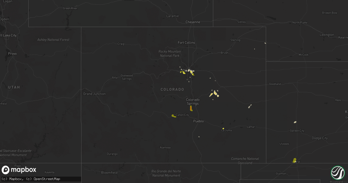
Hail Map in Colorado on August 21, 2019
Get this storm
August 21 map
$229
one time, instant access
Download today. No call, no setup
Keep the $229
Bought the map and want the full workflow? Apply the entire $229 to a subscription within 7 days. None of it is wasted.
Every map, not just this one
This buys you this map. Subscription and you get every map we run, in the markets you choose from a few cities to whole states to nationwide. Plus real-time alerts the moment a storm fires.
Contact data
Name, contact info, occupancy, even credit band for addresses in the footprint. You go from where it hit to who to call.
Become the source they trust
Unlimited branding weather history reports on demand. You already have the documented answer ready for the property owner, and you are the one who showed up with it.
Property data and RoofTrace estimates
Pull up any address you have got, its value and the exact code rules for that jurisdiction, straight from One Click Code. Then RoofTrace estimates the squares, pitch, and roof value, priced the way you price.
Storm reports in Colorado
Colorado
| Date | Description |
|---|---|
| 08/21/20194:06 PM CDT | Report from mping: ping pong ball |
| 08/21/20194:04 PM CDT | Report from mping: half dollar |
| 08/21/20197:32 AM CDT | At 1232 AM MDT, severe thunderstorms were located along a line extending from 7 miles east of Ellsworth to North Sterling Reservoir, moving east at 35 mph. These are very dangerous storms. HAZARD...80 mph wind gusts and quarter size hail. SOURCE...Radar indicated. IMPACT...Flying debris will be dangerous to those caught without shelter. Mobile homes will be heavily damaged. Expect considerable damage to roofs, windows, and vehicles. Extensive tree damage and power outages are likely. Locations impacted include... Alliance, Sidney, Lodgepole, Gurley, Colton, Sunol, Brownson, Lorenzo, Alliance Airport and Sidney Airport.This includes Interstate 80 in Nebraska between mile markers 48 and76. |
| 08/21/20194:06 AM CDT | At 905 PM CDT, a severe thunderstorm was located 9 miles northeast of Felt, or 10 miles west of Boise City, moving west at 10 mph. HAZARD...60 mph wind gusts. SOURCE...Radar indicated. IMPACT...Minor damage to roofs, siding, and trees is possible. Locations impacted include... Boise City, Keyes, Kenton, Wheeless, Black Mesa Park, Felt and Griggs. |
| 08/21/20192:39 AM CDT | At 739 PM MDT, a severe thunderstorm was located near Sedalia, or 23 miles south of Denver, moving east at 10 mph. HAZARD...Quarter size hail. SOURCE...Radar indicated. IMPACT...Damage to vehicles is expected. Locations impacted include... Castle Rock, southwestern Parker, Sedalia, Castle Pines and Louviers. |
| 08/21/20191:34 AM CDT | At 634 PM MDT, a severe thunderstorm was located over western Aurora, or 8 miles southeast of Denver, moving northwest at 5 mph. HAZARD...60 mph wind gusts and quarter size hail. SOURCE...Radar indicated. IMPACT...Expect damage to roofs, siding, and trees. Hail damage to vehicles is expected. Locations impacted include... Denver, Aurora, eastern Centennial, Greenwood Village, Arapahoe Park and Buckley AFB. |
| 08/21/20191:03 AM CDT | At 602 PM MDT, a severe thunderstorm was located over northeastern Denver, moving west at 5 mph. HAZARD...Quarter size hail. SOURCE...Radar indicated. IMPACT...Damage to vehicles is expected. Locations impacted include... Denver and southwestern Commerce City. |
| 08/20/201911:22 PM CDT | Hailed for 20 minutes. |
| 08/20/201911:09 PM CDT | At 408 PM MDT, a severe thunderstorm was located over Texas Creek, or 12 miles northeast of Hayden Pass Burn Scar, moving northeast at 15 mph. HAZARD...60 mph wind gusts and quarter size hail. SOURCE...Radar indicated. IMPACT...Hail damage to vehicles is expected. Expect wind damage to roofs, siding, and trees. Locations impacted include... Texas Creek, Royal Gorge and Canon City. |
| 08/20/201910:08 PM CDT | At 307 PM MDT, a severe thunderstorm was located 11 miles southwest of Fountain, or 16 miles south of Colorado Springs, moving south at 15 mph. HAZARD...Half dollar size hail. SOURCE...Public. IMPACT...Damage to vehicles is expected. Locations impacted include... Southern Colorado Springs, Fountain, Stratmoor, Penrose, Fort Carson, Pueblo West, Pinon, Security and Security-Widefield. |
| 08/20/20197:45 PM CDT | A local report indicates 1.00 inch wind near 3 SE DENVER |
| 08/20/20197:41 PM CDT | A local report indicates 1.00 inch wind near 1 N GENESEE |
| 08/20/20197:40 PM CDT | A local report indicates 1.00 inch wind near 3 W AURORA |
| 08/20/20197:27 PM CDT | A local report indicates 1.00 inch wind near 3 SW LAKEWOOD |
All States Impacted by Hail Map on August 21, 2019
Cities Impacted by Hail Map on August 21, 2019
- Albion, IL
- Augusta, KS
- Andover, KS
- Casper, WY
- Sedan, KS
- Longton, KS
- Morrison, CO
- Denver, CO
- Williamsburg, KS
- Yoder, WY
- Hawk Springs, WY
- Littleton, CO
- Chesterfield, MO
- Ballwin, MO
- Tennyson, IN
- Gentryville, IN
- Richland, IN
- Chrisney, IN
- Rockport, IN
- Portageville, MO
- Trafford, AL
- Warrior, AL
- Matheson, CO
- Belleview, MO
- Belgrade, MO
- Benedict, KS
- Elk City, KS
- Independence, KS
- Neodesha, KS
- Fredonia, KS
- Texhoma, OK
- Kenton, OK
- Boise City, OK
- Mount Hope, KS
- Chugwater, WY
- Cambridge, KS
- Loogootee, IN
- Jasper, IN
- Dubois, IN
- Peace Valley, MO
- Goddard, KS
- Colwich, KS
- Garden Plain, KS
- Andale, KS
- Wichita, KS
- Cheney, KS
- Haven, KS
- Viola, KS
- Moundville, MO
- Nevada, MO
- Goodwell, OK
- Princeton, IN
- Patoka, IN
- Burrton, KS
- Black Eagle, MT
- Cascade, MT
- Great Falls, MT
- Milo, MO
- Walker, MO
- Worland, WY
- Bluford, IL
- Dale, IN
- Whitewater, KS
- Aurora, CO
- Agate, CO
- Halstead, KS
- Garnett, KS
- Greeley, KS
- Richmond, KS
- Princeton, KS
- Conway Springs, KS
- Floral, AR
- Newton, KS
- Noble, IL
- Harwood, MO
- El Dorado Springs, MO
- Inman, KS
- Rocky Ford, CO
- Wayne City, IL
- Keenes, IL
- Mount Vernon, IL
- Fairfield, IL
- Sims, IL
- Rock, KS
- Doswell, VA
- Liberal, KS
- Hugoton, KS
- Thermopolis, WY
- Kirby, WY
- Salem, MO
- Niotaze, KS
- Peru, KS
- Clearwater, KS
- Maize, KS
- Lebanon, MO
- Eldridge, MO
- Kaycee, WY
- La Cygne, KS
- Arkansas City, KS
- Garden City, KS
- Holcomb, KS
- Sedgwick, KS
- Valley Center, KS
- Marthasville, MO
- Windyville, MO
- Rolla, MO
- Power, MT
- Dexter, MO
- Fenton, MO
- Douglass, KS
- Golden, CO
- Stockton, MO
- Argenta, IL
- Derby, KS
- Waverly, KS
- Hutchinson, KS
- Dexter, KS
- Holland, IN
- Moline, KS
- Floweree, MT
- Deepwater, MO
- Osceola, MO
- Lowry City, MO
- Guymon, OK
- Richland, MO
- Turpin, OK
- Simla, CO
- Ramah, CO
- Calhan, CO
- Westphalia, KS
- Bentley, KS
- Milton, KS
- Norwich, KS
- Haysville, KS
- Poseyville, IN
- Liberal, MO
- Stoutland, MO
- Caledonia, MO
- Rector, AR
- Welda, KS
- Colony, KS
- Mount Vernon, IN
- Evansville, IN
- Pleasanton, KS
- Amoret, MO
- Udall, KS
- Pomona, KS
- Quenemo, KS
- Bigelow, AR
- Otwell, IN
- Potosi, MO
- Mineral Point, MO
- Owensboro, KY
- Grenola, KS
- Paragould, AR
- Harrisburg, NE
- Lyman, NE
- Buhler, KS
- Moundridge, KS
- Cannelburg, IN
- Butler, MO
- Ellery, IL
- Shoals, IN
- French Lick, IN
- Bunker, MO
- Bloomfield, MO
- Dix, NE
- Urbana, MO
- Jerico Springs, MO
- Lockwood, MO
- Boss, MO
- Buffalo, WY
- Yuma, CO
- Le Roy, KS
- Garrett, WY
- West Salem, IL
- Hazleton, IN
- Vincennes, IN
- Owensville, IN
- Allendale, IL
- New Harmony, IN
- Wadesville, IN
- Grayville, IL
- Mount Carmel, IL
- Decker, IN
- Griffin, IN
- Petersburg, IN
- Meriden, WY
- Malden, MO
- Newburg, MO
- Edgar Springs, MO
- Rose Hill, KS
- Walsenburg, CO
- Lawrenceville, IL
- Bridgeport, IL
- Bushnell, NE
- East Earl, PA
- Iuka, IL
- Francisco, IN
- Parma, MO
- Williamsville, MO
- Ironton, MO
- Middle Brook, MO
- Lesterville, MO
- Saint James, MO
- Forgan, OK
- Atlanta, KS
- Lilbourn, MO
- Ferdinand, IN
- Newburgh, IN
- Englewood, CO
- Appleton City, MO
- Black, MO
- Owensville, MO
- Dahlgren, IL
- Barnhill, IL
- Johnsonville, IL
- Winslow, IN
- Kit Carson, CO
- Dixon, MO
- Wheat Ridge, CO
- Conrad, MT
- Bono, AR
- Fontana, KS
- Claremont, IL
- Olney, IL
- Bronaugh, MO
- Sheldon, MO
- Boonville, IN
- Holyoke, CO
- Reading, KS
- Knobel, AR
- Dieterich, IL
- Lincoln City, IN
- Stendal, IN
- Oakland City, IN
- Santa Claus, IN
- Huntingburg, IN
- Birdseye, IN
- Saint Anthony, IN
- Lovington, IL
- Houston, AR
- Golden Gate, IL
- Fairfield, MT
- Sumner, IL
- Deer Trail, CO
- Poplar Bluff, MO
- Benton, KS
- Ingraham, IL
- Clay City, IL
- Rush, CO
- Lamar, MO
- Fort Leonard Wood, MO
- Centerville, MO
- Eureka, MO
- Pacific, MO
- Cisne, IL
- Cedar Vale, KS
- Burden, KS
- Winfield, KS
- Piggott, AR
- Wheatland, WY
- Parker, KS
- Flemington, MO
- Sedalia, CO
- Saint Louis, MO
- Fremont, MO
- Lysite, WY
- Shoshoni, WY
- Medicine Bow, WY
- Round Lake, NY
- Ballston Lake, NY
- Ballston Spa, NY
- Mechanicville, NY
- Troy, NY
- Latham, NY
- Albany, NY
- Waterford, NY
- Cohoes, NY
- Watervliet, NY
- Tyngsboro, MA
- Pelham, NH
- Hudson, NH
- Nashua, NH
- Andover, CT
- Columbia, CT
- Glastonbury, CT
- Bolton, CT
- Coventry, CT
- Manchester, CT
- Mansfield Center, CT
- Storrs Mansfield, CT
- Hebron, CT
- East Hartford, CT
- Union Mills, NC
- Marion, NC
- Bostic, NC
- Stony Point, NC
- Catawba, NC
- Conover, NC
- Claremont, NC
- Taylorsville, NC
- Hickory, NC
- Statesville, NC
- Oaktown, IN
- Saint Francisville, IL
- Bruceville, IN
- Bicknell, IN
- Oktaha, OK
- Checotah, OK
- Catoosa, OK
- Tulsa, OK
- Colorado Springs, CO
- Cotopaxi, CO
- Granite Falls, NC
- College Park, MD
- Bowie, MD
- Hyattsville, MD
- Lanham, MD
- Silver Spring, MD
- Harwood, MD
- Upper Marlboro, MD
- Bladensburg, MD
- Glenn Dale, MD
- Takoma Park, MD
- Greenbelt, MD
- Riverdale, MD
- Saratoga Springs, NY
- Schuylerville, NY
- Wethersfield, CT
- Canterbury, CT
- Brooklyn, CT
- Danielson, CT
- Dayville, CT
- Chaplin, CT
- North Windham, CT
- Foster, RI
- Hampton, CT
- Narvon, PA
- Mohnton, PA
- Morgantown, PA
- Douglassville, PA
- Elverson, PA
- Birdsboro, PA


