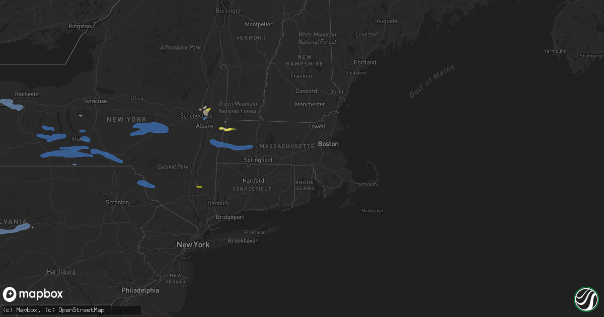
Hail Map in Massachusetts on August 8, 2019
Get this storm
August 8 map
$229
one time, instant access
Download today. No call, no setup
Keep the $229
Bought the map and want the full workflow? Apply the entire $229 to a subscription within 7 days. None of it is wasted.
Every map, not just this one
This buys you this map. Subscription and you get every map we run, in the markets you choose from a few cities to whole states to nationwide. Plus real-time alerts the moment a storm fires.
Contact data
Name, contact info, occupancy, even credit band for addresses in the footprint. You go from where it hit to who to call.
Become the source they trust
Unlimited branding weather history reports on demand. You already have the documented answer ready for the property owner, and you are the one who showed up with it.
Property data and RoofTrace estimates
Pull up any address you have got, its value and the exact code rules for that jurisdiction, straight from One Click Code. Then RoofTrace estimates the squares, pitch, and roof value, priced the way you price.
Storm reports in Massachusetts
Massachusetts
| Date | Description |
|---|---|
| 08/08/20196:10 PM CDT | Report relayed of tree down along daniel shays highway |
| 08/08/20196:05 PM CDT | Report relayed of tree down along silver st in hubbard corner part of agawam |
| 08/08/20196:00 PM CDT | Report relayed of trees/wires down near talcott ave and wistaria st |
| 08/08/20195:59 PM CDT | Report relayed of tree/wires down on school st and dwight st |
| 08/08/20195:51 PM CDT | Report relayed of tree/powerlines down near rt 202 and bugbee rd |
| 08/08/20195:29 PM CDT | Relayed report of trees/wires down on several streets. |
| 08/08/20195:26 PM CDT | Private backyard weather station |
| 08/08/20195:15 PM CDT | Trees and wires down. |
| 08/08/20195:15 PM CDT | Trees and wires down. |
| 08/08/20195:10 PM CDT | Multiple reports of trees down in and near the town of pittsfield. |
| 08/08/20195:08 PM CDT | Tree down blocking one lane of the mass pike westbound |
| 08/08/20195:05 PM CDT | Several white pines sheared 20 to 30 feet off the ground... And large dead poplar downed |
| 08/08/20195:01 PM CDT | Tree and wires down on interlaken road in stockbridge |
| 08/08/20194:27 PM CDT | Tree down with marble sized hail. |
| 08/08/20194:27 PM CDT | A local report indicates 1.00 inch wind near 2 SE ADAMS |
| 08/08/20191:45 AM CDT | At 645 PM EDT, severe thunderstorms were located along a line extending from near Winsted to Fahnestock State Park, moving east at 35 mph. HAZARD...60 mph wind gusts and penny size hail. SOURCE...Radar indicated. IMPACT...Expect damage to roofs, siding, and trees. Locations impacted include... Torrington, New Milford, Sherman, Pawling, Thomaston, New Hartford, Kent, Norfolk, Litchfield, Northwest Harwinton, Terryville, New Hartford Center, Woodbury Center, Gaylordsville, New Preston, Cornwall Bridge, Winsted, Wingdale, Dover Plains and Hopewell Junction. |
| 08/08/20191:08 AM CDT | At 605 PM EDT, a north to south line of severe thunderstorms across Berkshire County MA, from Williamstown down south to Sheffield, was moving east at 40 mph. HAZARD...60 mph wind gusts. SOURCE...Radar indicated. IMPACT...Expect damage to trees and power lines. Locations impacted include... Westfield, Holyoke, Amherst, Northampton, Agawam, West Springfield, Greenfield, Deerfield, South Hadley, Easthampton, Monroe, Southwick, Montague, Southampton, Hadley, Sunderland, Hatfield, Northfield, Williamsburg and Huntington. |
| 08/08/201912:48 AM CDT | At 547 PM EDT, severe thunderstorms were located along a line extending from near Pine Plains to near Ellenville, moving east at 40 mph. HAZARD...60 mph wind gusts. SOURCE...Trained weather spotters reported trees and wires down near Glasco and Kingston. IMPACT...Expect damage to roofs, siding, and trees. Severe thunderstorms will be near... Pine Plains around 555 PM EDT. Amenia and Millerton around 600 PM EDT. Sharon around 605 PM EDT. Wallkill and Modena around 610 PM EDT. Plattekill, Falls Village and Cornwall Bridge around 615 PM EDT. Beacon, Norfolk and Marlboro around 625 PM EDT. Torrington, Wappingers Falls, Fishkill and Myers Corner around 630 PM EDT. Hopewell Junction and Winsted around 635 PM EDT.Other locations impacted by these severe thunderstorms include NorrieHeights, Atwood, Lithgow, Hoxie Corner, South Amenia, Pleasant Ridge,Jackson Corners, Verbank, Bulls Bridge and Dempsey Landing. |
| 08/08/201912:36 AM CDT | At 536 PM EDT, severe thunderstorms were located along a line extending from near Ballston Spa to near Mechanicville to Troy, moving east at 50 mph. HAZARD...60 mph wind gusts and quarter size hail. SOURCE...Radar indicated. IMPACT...Hail damage to vehicles is expected. Expect wind damage to roofs, siding, and trees. Locations impacted include... Troy, Bennington, Clifton Park, Saratoga Springs, Cohoes, Watervliet, Rensselaer, Mechanicville, Hoosick Falls, Arlington, Salem, Manchester, Stratton, Latham, Milton, Ballston Spa, Menands, Shaftsbury, Pownal and Green Island. |
| 08/08/201912:10 AM CDT | At 510 AM EDT, a severe thunderstorm was located near Nantucket, moving northeast at 30 mph. HAZARD...60 mph wind gusts. SOURCE...Radar indicated. IMPACT...Expect damage to trees and power lines. Locations impacted include... Nantucket. |
| 08/08/201912:09 AM CDT | At 508 PM EDT, a severe thunderstorm was located over New Ashford, or 8 miles southwest of North Adams, moving east at 20 mph. HAZARD...60 mph wind gusts and quarter size hail. SOURCE...Radar indicated. IMPACT...Hail damage to vehicles is expected. Expect wind damage to roofs, siding, and trees. Locations impacted include... North Adams, Adams, Cheshire, Florida, Savoy, New Ashford, Soldiers Memorial Field, North Hancock, Cheshire Harbor, Arnoldville, Town Crest Village, Maple Grove, Eastern Summit, Zylonite, Bowens Corners, Farnams, Rusek Whipple Square, Renfrew, Savoy Center and Brier. |
| 08/07/201911:44 PM CDT | At 443 PM EDT, a severe thunderstorm was located near Stephentown, or 12 miles northwest of Pittsfield, moving east at 15 mph. HAZARD...60 mph wind gusts and quarter size hail. SOURCE...Radar indicated. IMPACT...Hail damage to vehicles is expected. Expect wind damage to roofs, siding, and trees. Locations impacted include... Hancock, New Ashford, Center Berlin, Cherryplain, Stephentown Center, North Stephentown, Sweets Corner, North Hancock, South Williamstown and Steeles Corners. |
| 08/07/201911:25 PM CDT | At 424 AM EDT, a severe thunderstorm was located 8 miles east of Edgartown, moving northeast at 30 mph. HAZARD...60 mph wind gusts. SOURCE...Radar indicated. IMPACT...Expect damage to trees and power lines. Locations impacted include... Nantucket, Brewster, Edgartown, Dennis, Harwich, Chatham, Orleans, Eastham and Wellfleet. |
| 08/07/201910:48 PM CDT | At 347 AM EDT, a severe thunderstorm was located 10 miles west of Nantucket, moving northeast at 30 mph. HAZARD...60 mph wind gusts. SOURCE...Radar indicated. IMPACT...Expect damage to trees and power lines. Locations impacted include... Nantucket. |
| 08/07/201910:34 PM CDT | At 334 AM EDT, a severe thunderstorm was located near Truro, or near Provincetown, moving northeast at 30 mph. HAZARD...60 mph wind gusts. SOURCE...Radar indicated. IMPACT...Expect damage to trees and power lines. Locations impacted include... Brewster, Provincetown, Orleans, Eastham, Wellfleet and Truro. |
| 08/07/20199:59 PM CDT | At 259 AM EDT, a severe thunderstorm was located over Edgartown, moving northeast at 30 mph. HAZARD...60 mph wind gusts. SOURCE...Radar indicated. IMPACT...Expect damage to trees and power lines. Locations impacted include... Barnstable, Falmouth, Brewster, Oak Bluffs, Edgartown, Tisbury, Yarmouth, Sandwich, Bourne, Dennis, Mashpee, Harwich, Chatham, Orleans, West Tisbury, Chilmark and Hyannis. |
| 08/07/20198:19 PM CDT | At 119 AM EDT, a severe thunderstorm was located over Easton, or near Brockton, moving northeast at 30 mph. HAZARD...60 mph wind gusts. SOURCE...Radar indicated. IMPACT...Expect damage to trees and power lines. Locations impacted include... Boston, Brockton, Quincy, Taunton, Weymouth, Salem, Braintree, Randolph, Stoughton, Bridgewater, Marshfield, Attleboro, Mansfield, Middleborough, Easton, Hingham, Canton, Marblehead, Norton and Scituate. |
| 08/07/20198:00 PM CDT | At 100 AM EDT, a severe thunderstorm was located near Newport, moving northeast at 30 mph. HAZARD...60 mph wind gusts. SOURCE...Radar indicated. IMPACT...Expect damage to trees and power lines. Locations impacted include... New Bedford, Fall River, Warwick, Taunton, East Providence, Dartmouth, North Kingstown, Newport, Bristol, Attleboro, Norton, Somerset, Portsmouth, Barrington, Middletown, Fairhaven, Swansea, Tiverton, Westport and Seekonk. |
All States Impacted by Hail Map on August 8, 2019
Cities Impacted by Hail Map on August 8, 2019
- Amelia, NE
- Taylor, NE
- Chambers, NE
- Burwell, NE
- Saint Marys, OH
- Celina, OH
- Racine, OH
- Springfield, OH
- Urbana, OH
- Saint Paris, OH
- Tremont City, OH
- Mcconnelsville, OH
- Oakdale, PA
- Hulett, WY
- Dexter City, OH
- Lowell, OH
- Coal Run, OH
- Macksburg, OH
- Beverly, OH
- Blue Rock, OH
- Caldwell, OH
- Guysville, OH
- Belleville, WV
- Reedsville, OH
- Stewart, OH
- Athens, OH
- Coolville, OH
- Amesville, OH
- Washington, WV
- Karval, CO
- Hugo, CO
- Arrowsmith, IL
- Bellflower, IL
- Saybrook, IL
- Hershey, NE
- Sutherland, NE
- North Vernon, IN
- Springfield, CO
- Two Buttes, CO
- Cameron, OK
- Poteau, OK
- Walsh, CO
- Saratoga Springs, NY
- Mechanicville, NY
- Parker, CO
- Bennett, CO
- Aurora, CO
- Palestine, WV
- Rockport, WV
- Elizabeth, WV
- Sandyville, WV
- Johnson, KS
- Richfield, KS
- Stella, NC
- Newport, NC
- Swansboro, NC
- Stapleton, NE
- Logan, NM
- Gillette, WY
- Amarillo, TX
- Mount Pleasant, SC
- Isle Of Palms, SC
- Bloomington, IL
- Downs, IL
- Elizabeth, CO
- Watkins, CO
- Ramah, CO
- Paxton, NE
- Coldwater, OH
- Indianapolis, IN
- Saint Henry, OH
- New Weston, OH
- Maria Stein, OH
- Curtis, NE
- Dickens, NE
- Maywood, NE
- Wellfleet, NE
- North Platte, NE
- Havelock, NC
- Moravia, NY
- Auburn, NY
- Simla, CO
- Matheson, CO
- Pomeroy, OH
- Mosquero, NM
- Clayton, NM
- Saint Marys, WV
- Ellenboro, WV
- Cairo, WV
- Somerset, PA
- Champion, PA
- Anna, OH
- Geneva, IN
- Sidney, OH
- Berne, IN
- Port Jefferson, OH
- Fort Recovery, OH
- Fort Loramie, OH
- Chickasaw, OH
- Maplewood, OH
- Bryant, IN
- Bluffton, IN
- Minster, OH
- Charleston, WV
- Buffalo, WY
- Raton, NM
- Capulin, NM
- San Jon, NM
- Crawfordsville, IN
- Elkhart, KS
- Las Animas, CO
- Arapahoe, NC
- Tyler, AL
- Beech Grove, IN
- New Matamoras, OH
- Newport, OH
- Marietta, OH
- Reno, OH
- Orient, OH
- Mcalester, OK
- Quinton, OK
- Stephentown, NY
- Alzada, MT
- New Salem, ND
- Hazen, ND
- Beulah, ND
- Broken Bow, NE
- Versailles, OH
- Yorkshire, OH
- Rossburg, OH
- New Ross, IN
- Conchas Dam, NM
- Patagonia, AZ
- Merna, NE
- Bismarck, IL
- Center, ND
- Buckeye Lake, OH
- Hebron, OH
- Pataskala, OH
- Granville, OH
- Whitman, NE
- Folsom, NM
- London, OH
- Georgetown, IL
- Vilas, CO
- Indianola, IL
- Imperial, PA
- Ridge Farm, IL
- Chrisman, IL
- Mineral Wells, WV
- Lanesborough, MA
- Williamstown, MA
- Sugar City, CO
- Covington, OH
- Pleasant Hill, OH
- Ludlow Falls, OH
- West Milton, OH
- Troy, OH
- Bradford, OH
- Williamstown, WV
- Harrisville, WV
- Pennsboro, WV
- Stinnett, TX
- Wendover, UT
- Merrimack, NH
- Parkersburg, WV
- Malta, OH
- Little Hocking, OH
- Corning, OH
- Cutler, OH
- Glouster, OH
- Chesterhill, OH
- Stockport, OH
- Vincent, OH
- Belpre, OH
- Greenwood, IN
- Beaufort, NC
- Covington, IN
- Williamsport, IN
- Big Pine, CA
- New Bern, NC
- Somerset, OH
- Junction City, OH
- Bremen, OH
- Rushville, OH
- Arthur, NE
- Olney Springs, CO
- Pearson, GA
- Maxwell, NE
- Millington, TN
- Memphis, TN
- Claude, TX
- Atlantic Beach, NC
- Maysville, NC
- Hubert, NC
- Salter Path, NC
- Emerald Isle, NC
- Le Roy, WV
- Hereford, TX
- New Market, IN
- Ladoga, IN
- Berlin, NY
- Mendon, OH
- Spencerville, OH
- Rockford, OH
- Rockwood, PA
- Pullman, WV
- Penfield, IL
- Attica, IN
- South Bloomingville, OH
- Petersburg, NY
- Canton, MS
- Opp, AL
- Kenvil, NJ
- Mine Hill, NJ
- Oklahoma City, OK
- Banks, AR
- Gabbs, NV
- Douglas, GA
- Gruver, TX
- Albany, OH
- Richmond, IN
- Blackshear, GA
- Wapakoneta, OH
- Botkins, OH
- Brady, NE
- Shade, OH
- Powell Butte, OR
- Smithville, WV
- Thornville, OH
- Ravenswood, WV
- Crescent, OK
- Marshall, IN
- Waveland, IN
- Dunning, NE
- Lebanon, IN
- Spencer, IN
- Luning, NV
- Kingman, IN
- Baltimore, OH
- Thurston, OH
- Millersport, OH
- Pleasantville, OH
- Ansonia, OH
- Greenville, OH
- Panhandle, TX
- Willacoochee, GA
- Nara Visa, NM
- Oriental, NC
- Lakeland, GA
- Wilkesville, OH
- Okemah, OK
- Waterford, NY
- Sullivans Island, SC
- Macfarlan, WV
- Hennessey, OK
- Yukon, OK
- Cumberland, OH
- Chandlersville, OH
- Philo, OH
- Ozark, AR
- Mulberry, AR
- Selma, AL
- Gettysburg, OH
- Foosland, IL
- Boone, CO
- Greeley, NE
- Kaycee, WY
- Chipley, FL
- Piedmont, OK
- Whipple, OH
- Schurz, NV
- Fort Morgan, CO
- Aliceville, AL
- Clifton Park, NY
- Ballston Lake, NY
- Danville, IL
- Alvin, IL
- State Line, IN
- Schaghticoke, NY
- Cohoes, NY
- Melrose, NY
- Kinston, AL
- Thorntown, IN
- Jamestown, IN
- Darlington, IN
- Mill Hall, PA
- Brewster, NE
- Whiteland, IN
- Edinburgh, IN
- Walker, WV
- Jet, OK
- New Straitsville, OH
- Shawnee, OH
- Spearman, TX
- Cheshire, MA
- Needham, IN
- Franklin, IN
- Trimble, OH
- Jacksonville, OH
- Rye, CO
- Walsenburg, CO
- Zanesville, OH
- Fleming, CO
- Manter, KS
- Prineville, OR
- Edgemont, SD
- Fleming, OH
- Okarche, OK
- Bend, OR
- Portland, IN
- New Bremen, OH
- Houston, OH
- Osgood, OH
- Russia, OH
- Piqua, OH
- Fairmount, IL
- Mershon, GA
- Hillsboro, IN
- Waynetown, IN
- Waverly, WV
- Mill Run, PA
- Normalville, PA
- Bridgeville, PA
- Carnegie, PA
- Bethel Park, PA
- Presto, PA
- Pittsburgh, PA
- Tarrs, PA
- Irwin, PA
- Mount Pleasant, PA
- Madison, PA
- Ruffs Dale, PA
- West Newton, PA
- Hunker, PA
- New Stanton, PA
- Herminie, PA
- Darragh, PA
- Julian, PA
- Milesburg, PA
- Howard, PA
- Philipsburg, PA
- Hawk Run, PA
- Morrisdale, PA
- Allport, PA
- Munson, PA
- West Decatur, PA
- Bellefonte, PA
- Wallaceton, PA
- Tyler Hill, PA
- Damascus, PA
- Lake Huntington, NY
- Callicoon, NY
- Swan Lake, NY
- Honesdale, PA
- Equinunk, PA
- Narrowsburg, NY
- Cochecton, NY
- Bethel, NY
- White Lake, NY
- Milanville, PA
- Waldron, IN
- Milroy, IN
- Shelbyville, IN
- Fairland, IN
- Manilla, IN
- Saint Paul, IN
- Boggstown, IN
- South Vienna, OH
- Muleshoe, TX
- Adams, MA
- Des Moines, NM
- Elba, NY
- Honeoye Falls, NY
- Oakfield, NY
- Bergen, NY
- Scottsville, NY
- Pavilion, NY
- Avon, NY
- Batavia, NY
- Byron, NY
- South Byron, NY
- Rush, NY
- Le Roy, NY
- Caledonia, NY
- Stafford, NY
- Branchport, NY
- Naples, NY
- Penn Yan, NY
- Keuka Park, NY
- Dundee, NY
- Watkins Glen, NY
- Bradford, NY
- Hector, NY
- Rock Stream, NY
- Hammondsport, NY
- Cohocton, NY
- Bath, NY
- Prattsburgh, NY
- Burdett, NY
- Avoca, NY
- Freeville, NY
- Groton, NY
- Lansing, NY
- Brooktondale, NY
- Richford, NY
- Dryden, NY
- Ithaca, NY
- Slaterville Springs, NY
- Van Etten, NY
- Owego, NY
- Newark Valley, NY
- Beaver Dams, NY
- Corning, NY
- Big Flats, NY
- Cayuta, NY
- Addison, NY
- Horseheads, NY
- Spencer, NY
- Breesport, NY
- Lockwood, NY
- Elmira, NY
- Campbell, NY
- Millport, NY
- Lowman, NY
- Painted Post, NY
- Candor, NY
- Erin, NY
- Pine Valley, NY
- Alpine, NY
- Willseyville, NY
- Montour Falls, NY
- Newfield, NY
- Binghamton, NY
- Castle Creek, NY
- Chenango Forks, NY
- Johnson City, NY
- Endicott, NY
- Kirkwood, NY
- Berkshire, NY
- Harpursville, NY
- Windsor, NY
- Maine, NY
- Ouaquaga, NY
- Port Crane, NY
- Glen Aubrey, NY
- Chemung, NY
- Waverly, NY
- Roseboom, NY
- Summit, NY
- New Lisbon, NY
- Morris, NY
- Jefferson, NY
- Otego, NY
- West Oneonta, NY
- Cooperstown, NY
- Schenevus, NY
- Oneonta, NY
- Charlotteville, NY
- Westford, NY
- Maryland, NY
- Mount Vision, NY
- South New Berlin, NY
- Edmeston, NY
- Burlington Flats, NY
- West Burlington, NY
- East Worcester, NY
- Portlandville, NY
- Worcester, NY
- Richmondville, NY
- Laurens, NY
- Garrattsville, NY
- Gilbertsville, NY
- Hartwick, NY
- Milford, NY
- New Berlin, NY
- Austerlitz, NY
- Huntington, MA
- Lee, MA
- Canaan, NY
- Hinsdale, MA
- Chester, MA
- Easthampton, MA
- West Stockbridge, MA
- Old Chatham, NY
- Stockbridge, MA
- Chatham, NY
- Lenox, MA
- Richmond, MA
- Valatie, NY
- Lenox Dale, MA
- Becket, MA
- Florence, MA
- East Chatham, NY
- Spencertown, NY
- Latham, NY
- Watervliet, NY
- Nephi, UT
- Vernon, UT
- Wappingers Falls, NY
- Poughkeepsie, NY
- Fallon, NV


