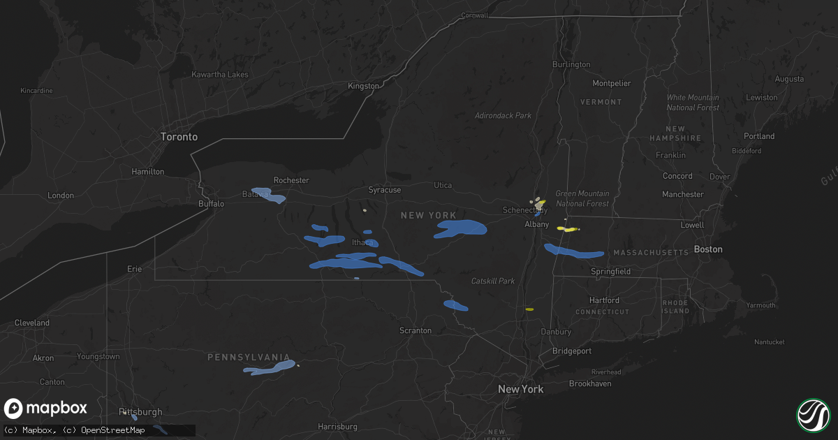
Hail Map in New York on August 8, 2019
Get this storm
August 8 map
$229
one time, instant access
Download today. No call, no setup
Keep the $229
Bought the map and want the full workflow? Apply the entire $229 to a subscription within 7 days. None of it is wasted.
Every map, not just this one
This buys you this map. Subscription and you get every map we run, in the markets you choose from a few cities to whole states to nationwide. Plus real-time alerts the moment a storm fires.
Contact data
Name, contact info, occupancy, even credit band for addresses in the footprint. You go from where it hit to who to call.
Become the source they trust
Unlimited branding weather history reports on demand. You already have the documented answer ready for the property owner, and you are the one who showed up with it.
Property data and RoofTrace estimates
Pull up any address you have got, its value and the exact code rules for that jurisdiction, straight from One Click Code. Then RoofTrace estimates the squares, pitch, and roof value, priced the way you price.
Storm reports in New York
New York
| Date | Description |
|---|---|
| 08/08/20196:55 PM CDT | Outlflow winds from a thunderstorm resulted in a downed tree at hoffman drive and woodhaven boulevard |
| 08/08/20195:34 PM CDT | Trees down on bruzgul road and clove valley road in the town of beekman. Time estimated by radar. |
| 08/08/20195:24 PM CDT | Tree down on maywood road. |
| 08/08/20195:13 PM CDT | A local report indicates 1.00 inch wind near 1 ENE RED OAKS MILL |
| 08/08/20195:06 PM CDT | State route 115 closed at cream street due to a downed tree and wires |
| 08/08/20194:55 PM CDT | A local report indicates 63 MPH wind near 3 ENE AUSTERLITZ |
| 08/08/20194:55 PM CDT | Tree and wires down in clintondale. |
| 08/08/20194:50 PM CDT | Tree on wires in shawungunk valley. |
| 08/08/20194:48 PM CDT | Tree down on a car |
| 08/08/20194:45 PM CDT | Trees down in stillwater. |
| 08/08/20194:45 PM CDT | Large tree branches down. Estimated wind of 60 mph. |
| 08/08/20194:45 PM CDT | Trees down in several locations throughout columbia county. |
| 08/08/20194:42 PM CDT | Power pole downed near intersection of routes 9 and 236 in halfmoon |
| 08/08/20194:40 PM CDT | Route 236 north and southbound is closed at route 9 in the town of halfmoon due to downed poles and wires. |
| 08/08/20194:40 PM CDT | Trees down in halfmoon township. |
| 08/08/20194:37 PM CDT | A local report indicates 59 MPH wind near LATHAM |
| 08/08/20194:33 PM CDT | Route 385 north and southbound closed due to downed wires. |
| 08/08/20194:30 PM CDT | Gazebo destroyed and trees down at hampton manor park |
| 08/08/20194:20 PM CDT | Tree down at winnie avenue and dempster street |
| 08/08/20194:20 PM CDT | Trees and wires down at several locations in greene county. |
| 08/08/20194:20 PM CDT | Tree down on fares road in coeymans |
| 08/08/20194:10 PM CDT | Tree down on wires along maple ave in the town of tribes hill. |
| 08/08/20194:08 PM CDT | Tree down on oak street in the town of fort johnson. |
| 08/08/20194:05 PM CDT | Tree down with wires. |
| 08/08/20194:02 PM CDT | Multiple reports of trees and wires down along county route 1... Route 143 and state route 32 in the town of westerlo. |
| 08/08/20194:00 PM CDT | Tree down in knox. |
| 08/08/20193:55 PM CDT | Tree down across burtonsville road. |
| 08/08/20193:55 PM CDT | Tree down across burtonsville road in the town of burtonsville. |
| 08/08/20193:52 PM CDT | Trees and wires down at the intersection of knox-gallupville road and berne-altamont road |
| 08/08/20193:50 PM CDT | Trees down in several places in schoharie county. |
| 08/08/20193:46 PM CDT | Dime to quarter size hail |
| 08/08/20193:29 PM CDT | Trees down blocking roads. |
| 08/08/20193:06 PM CDT | Trees and wires down. |
| 08/08/20193:00 PM CDT | Tree down in german flatts south of mohawk. |
| 08/08/20192:57 PM CDT | Trees and wires down. |
| 08/08/20192:51 PM CDT | Trees and wires down. |
| 08/08/20192:43 PM CDT | Trees and wires down. |
| 08/08/20192:42 PM CDT | Trees down blocking road. |
| 08/08/20192:40 PM CDT | Trees down in schaghticoke. |
| 08/08/20192:38 PM CDT | Trees and wires down. |
| 08/08/20192:38 PM CDT | Trees and wires down. |
| 08/08/20192:35 PM CDT | Trees and wires down. |
| 08/08/20192:35 PM CDT | Trees and wires down. |
| 08/08/20192:33 PM CDT | A local report indicates 1.00 inch wind near MECHANICVILLE |
| 08/08/20192:30 PM CDT | Trees down. |
| 08/08/20192:30 PM CDT | Tree down blocking road. |
| 08/08/20192:29 PM CDT | Several areas with trees and wires down... Including deyo hill road and oakdale road. |
| 08/08/20192:27 PM CDT | Trees and wires down on oak hill rd.... Near intersection with route 12. |
| 08/08/20192:15 PM CDT | Large tree across both lanes of route 26. |
| 08/08/20192:12 PM CDT | Power line down on house. |
| 08/08/20192:04 PM CDT | Trees down. |
| 08/08/20192:00 PM CDT | Trees down blocking roads. |
| 08/08/20191:50 PM CDT | Large tree down blocking road. |
| 08/08/20191:47 PM CDT | Powerlines down in the area. |
| 08/08/20191:40 PM CDT | Several trees down in multiple locations. Some involving wires. |
| 08/08/20191:35 PM CDT | Tree and wires down across road. |
| 08/08/20191:32 PM CDT | Wires down and tents blown away near wisner park downtown. Corner of gray and main st. |
| 08/08/20191:31 PM CDT | Trees and wires down. |
| 08/08/20191:30 PM CDT | Shingles blown off house. |
| 08/08/20191:25 PM CDT | Trees down. |
| 08/08/20191:20 PM CDT | A local report indicates 60 MPH wind near GROTON |
| 08/08/20191:14 PM CDT | Trees and wires down. |
| 08/08/20191:07 PM CDT | Trees and wires down. |
| 08/08/20191:05 PM CDT | Poles down. |
| 08/08/20191:00 PM CDT | Trees and wires down blocking road. |
| 08/08/201912:57 PM CDT | Numerous trees and wires down. |
| 08/08/201912:47 PM CDT | Trees and wires down. |
| 08/08/201912:39 PM CDT | Multiple trees down on county road 39. |
| 08/08/201912:36 PM CDT | Trees and wires down on route 54 south of penn yan village. |
| 08/08/201912:30 PM CDT | Trees and wires down on main street |
| 08/08/201912:25 PM CDT | Trees and wires down |
| 08/08/201912:21 PM CDT | Trees down blocking road. |
| 08/08/201912:11 PM CDT | Tree down on taylor road. Time estimated. |
| 08/08/201912:10 PM CDT | Multiple trees down on county road 39. |
| 08/08/201912:03 PM CDT | Trees and wires down. |
| 08/08/201912:00 PM CDT | Trees and wires down in bolivar. Time estimated. |
| 08/08/201912:00 PM CDT | Trees and wires down. |
| 08/08/201911:52 AM CDT | Tree on wires on county road 36. Time estimated. |
| 08/08/201911:49 AM CDT | Tree down near cox road and county road 14. Time estimated. |
| 08/08/201911:48 AM CDT | Tree down near 5/20 and county road 37. Time estimated. |
| 08/08/201911:48 AM CDT | Trees and powerlines down. Time estimated. |
| 08/08/201911:46 AM CDT | Trees and wires down. Time estimated. |
| 08/08/201911:45 AM CDT | Trees and wires down. Time estimated. |
| 08/08/201911:45 AM CDT | Trees and wires down in portville...time estimated. Report from cattaraugus county sheriff |
| 08/08/201911:45 AM CDT | Tree down on wires on curtis rd. Time estimated. |
| 08/08/201911:42 AM CDT | Trees and wires down. Time estimated. |
| 08/08/201911:39 AM CDT | Tree down on the 1300 block of macedon center rd. Time estimated. |
| 08/08/201911:36 AM CDT | Trees and wires down. Time estimated. |
| 08/08/201911:36 AM CDT | Trees and powerlines down in olean. Time estimated |
| 08/08/201911:36 AM CDT | Trees and wires down. Time estimated. |
| 08/08/201911:34 AM CDT | Tree down blocking kennedy road in the town of penfield. Time estimated |
| 08/08/201911:34 AM CDT | Trees and wires down. Time estimated. |
| 08/08/201911:32 AM CDT | Trees and powerlined down. Time estimated. |
| 08/08/201911:25 AM CDT | Tree down on wires on the 900 block of south washington. Time estimated. |
| 08/08/201911:24 AM CDT | Tree down on powerlines near jefferson and eastview terrace. Time estimated. |
| 08/08/201911:03 AM CDT | Powerlines down on robin crescent. Time estimated |
| 08/08/201910:59 AM CDT | Tree down on miller road in the town of gainesville. Time estimated. |
| 08/08/201910:50 AM CDT | Tree down blocking the road at brockport middle school. |
| 08/08/201910:23 AM CDT | Multiple reports of trees and wires down |
| 08/08/201910:00 AM CDT | Trees and lines down on route 60 at route 83 |
| 08/08/201910:00 AM CDT | Trees and branches reported down on washburn st between oliver st and spalding st. |
| 08/08/20197:53 AM CDT | At 1253 PM EDT, a severe thunderstorm was located near Weston Mills, or near Olean, moving east at 30 mph. HAZARD...60 mph wind gusts. SOURCE...Radar indicated. IMPACT...Expect damage to roofs, siding, and trees. Locations impacted include... Wellsville, Whitesville, Weston Mills, Scio, Bolivar, Andover, Portville, Alma, Richburg and Stannards. |
| 08/08/20197:39 AM CDT | At 1239 PM EDT, severe thunderstorms were located along a line extending from near Webster to near Conesus to 7 miles east of Belfast, moving southeast at 50 mph. HAZARD...60 mph wind gusts and penny size hail. SOURCE...Radar indicated. IMPACT...Expect damage to roofs, siding, and trees. Locations impacted include... Hornell, Bath, Penn Yan, Benton, Urbana, Canisteo, Potter, Wayland, Middlesex and Howard. |
| 08/08/20197:38 AM CDT | At 1238 PM EDT, severe thunderstorms were located along a line extending from Avon to 8 miles west of Dansville, moving east at 25 mph. HAZARD...60 mph wind gusts and penny size hail. SOURCE...Radar indicated. IMPACT...Expect damage to roofs, siding, and trees. Locations impacted include... Geneva, Canandaigua, Geneseo, Dansville, Avon, Conesus, Bristol, Lima, Bloomfield and Naples. This includes Interstate 390 between exits 4 and 6, and betweenexits 8 and 10. |
| 08/08/20197:20 AM CDT | At 1219 PM EDT, severe thunderstorms were located along a line extending from near Greece to near Scottsville to 6 miles east of Pavilion, moving east at 35 mph. HAZARD...60 mph wind gusts. SOURCE...Radar indicated. IMPACT...Expect damage to roofs, siding, and trees. Locations impacted include... Canandaigua, East Rochester, Webster, Fairport, Brighton, Ontario, Penfield, Newark, Williamson and Marion. This includes Interstate 90 between exits 45 and 42. |
| 08/08/20196:50 AM CDT | At 1149 AM EDT, severe thunderstorms were located along a line extending from near Hamlin Beach State Park to Byron to near Attica, moving east at 35 mph. HAZARD...60 mph wind gusts. SOURCE...Radar indicated. IMPACT...Expect damage to roofs, siding, and trees. Locations impacted include... Rochester, Greece, Irondequoit, Chili, Brockport, East Rochester, Hilton, Webster, Fairport and Brighton. This includes the following highways... Interstate 390 between exits 10 and 12. Interstate 90 between exits 47 and 46. |
| 08/08/20196:45 AM CDT | At 1145 AM EDT, severe thunderstorms were located along a line extending from Bennington to 8 miles west of Salamanca, moving east at 10 mph. HAZARD...60 mph wind gusts. SOURCE...Radar indicated. IMPACT...Expect damage to roofs, siding, and trees. Locations impacted include... Salamanca, Allegany State Park, Springville, Warsaw, Bennington, Attica, Ashford, Arcade, Franklinville and Ashford Hollow. This includes Interstate 86 between exits 20 and 21. |
| 08/08/20196:15 AM CDT | At 1115 AM EDT, severe thunderstorms were located along a line extending from 7 miles northeast of Newfane to near Alden, moving northeast at 35 mph. HAZARD...60 mph wind gusts. SOURCE...Radar indicated. IMPACT...Expect damage to roofs, siding, and trees. Locations impacted include... Batavia, Medina, Albion, Darien Lakes State Park, Hamlin Beach State Park, Le Roy, Pembroke, Akron, Alden and Attica. This includes Interstate 90 between exits 48A and 47. |
| 08/08/20195:48 AM CDT | At 1048 AM EDT, a severe thunderstorm was located over Kenmore, moving east at 35 mph. HAZARD...60 mph wind gusts. SOURCE...Radar indicated. IMPACT...Expect damage to roofs, siding, and trees. Locations impacted include... Buffalo, Cheektowaga, West Seneca, North Tonawanda, Clarence, Lackawanna, Kenmore, Depew, Amherst and Tonawanda. This includes Interstate 90 between exits 55 and 49. |
| 08/08/20195:39 AM CDT | At 1039 AM EDT, severe thunderstorms were located along a line extending from 17 miles northwest of Angola on the Lake to Findley Lake, moving east at 35 mph. HAZARD...60 mph wind gusts. SOURCE...Radar indicated. IMPACT...Expect damage to roofs, siding, and trees. Locations impacted include... West Seneca, Jamestown, Lackawanna, Dunkirk, Fredonia, Hamburg, East Aurora, Evans, Boston and Eden. This includes the following highways... Interstate 90 between exits 60 and 56. Interstate 86 between exits 4 and 16. |
| 08/08/20195:35 AM CDT | At 1034 AM EDT, severe thunderstorms were located along a line extending from Youngstown to near Niagara Falls to near Grand Island, moving northeast at 50 mph. HAZARD...60 mph wind gusts. SOURCE...Radar indicated. IMPACT...Expect damage to roofs, siding, and trees. Locations impacted include... North Tonawanda, Lockport, Amherst, Tonawanda, Grand Island, Newfane, Pendleton, Lewiston, Sanborn and Wilson. |
| 08/08/201912:13 AM CDT | At 512 PM EDT, a severe thunderstorm was located near Hagaman, or near Amsterdam, moving northeast at 35 mph. HAZARD...60 mph wind gusts and quarter size hail. SOURCE...Trained weather spotters reported trees down near Amsterdam. IMPACT...Hail damage to vehicles is expected. Expect wind damage to roofs, siding, and trees. This severe thunderstorm will be near... Glenville around 520 PM EDT. Galway around 525 PM EDT. Milton, Ballston Spa, Rock City Falls and North Ballston Spa around 540 PM EDT. Saratoga Springs around 555 PM EDT. Corinth around 600 PM EDT.Other locations impacted by this severe thunderstorm include ParkisMills, Deans Corners, West Perth, Munsonville, Shaw Corners, ChurchCorners, Kings Station, Barkersville, West Milton and Glenwild. |
| 08/07/201911:39 PM CDT | At 438 PM EDT, severe thunderstorms were located along a line extending from near Roxbury to Arkville to near Peabrook, moving east at 45 mph. HAZARD...60 mph wind gusts. SOURCE...Radar indicated. IMPACT...Expect damage to roofs, siding, and trees. Severe thunderstorms will be near... Prattsville around 445 PM EDT. Phoenicia and Woodland Valley Campground around 455 PM EDT. Hunter, Windham, Lanesville and Mount Tremper around 500 PM EDT. Kenneth L Wilson Campground around 505 PM EDT. Woodstock and West Hurley around 510 PM EDT. North-South Lake Campground around 515 PM EDT. Saugerties and Lake Katrine around 520 PM EDT. Catskill, Saugerties South and Napanoch around 525 PM EDT.Other locations impacted by these severe thunderstorms include MapleHill, Atwood, Katsbaan, Shultis Corners, Pacama, Brodhead, OtterHook, Climax, Zena and High Woods. |
| 08/07/201911:19 PM CDT | At 418 PM EDT, a severe thunderstorm was located near Waterford, or near Cohoes, moving east at 15 mph. HAZARD...60 mph wind gusts and quarter size hail. SOURCE...Radar indicated. IMPACT...Hail damage to vehicles is expected. Expect wind damage to roofs, siding, and trees. Locations impacted include... Mechanicville, Waterford, Country Knolls, Halfmoon, Pittstown, Schaghticoke, Valley Falls, Schaghticoke Hill, Melrose, Johnsonville, Willow Glen, Coons, Newtown, Pleasantdale, Factory Hollow, Grays Corners, East Pittstown, Grant Hollow, Stillwater Junction and Speigletown. |
| 08/07/201911:09 PM CDT | At 408 PM EDT, severe thunderstorms were located along a line extending from near Jordanville to near Worcester to near Delhi, moving east at 45 mph. HAZARD...60 mph wind gusts. SOURCE...Radar indicated. IMPACT...Expect damage to roofs, siding, and trees. Severe thunderstorms will be near... Summit around 420 PM EDT. Fort Plain, St. Johnsville and Richmondville around 425 PM EDT. Cobleskill, Canajoharie and Ames around 430 PM EDT. Ephratah and Breakabeen around 435 PM EDT. Middleburgh, Schoharie and Central Bridge around 440 PM EDT. Gloversville, Johnstown and Fonda around 445 PM EDT. Tribes Hill around 450 PM EDT. Amsterdam, Berne and Fort Johnson around 455 PM EDT.Other locations impacted by these severe thunderstorms include Meco,Charleston, East Berne, West Berne, Huntersland, Engleville, QuakerStreet, Broome Center, West Fulton and Mindenville. |
| 08/07/201910:51 PM CDT | At 351 PM EDT, a severe thunderstorm was located over Hartwick, or 7 miles west of Cooperstown, moving east at 40 mph. HAZARD...60 mph wind gusts and penny size hail. SOURCE...Radar indicated. IMPACT...Expect damage to roofs, siding, and trees. Locations impacted include... Oneonta, Davenport, Worcester, Middlefield, Hartwick, Maryland, Cooperstown, Westville, Kortright and Springfield. |
| 08/07/201910:42 PM CDT | At 342 PM EDT, severe thunderstorms were located along a line extending from Bainbridge to near Brackney to near Le Roy, moving east at 45 mph. HAZARD...60 mph wind gusts and penny size hail. SOURCE...Radar indicated. IMPACT...Expect damage to roofs, siding, and trees. Locations impacted include... Kirkwood, Conklin, Rush, Sidney, Jackson, Walton, Delhi, Davenport, Towanda and Sanford. |
| 08/07/201910:39 PM CDT | At 339 PM EDT, severe thunderstorms were located along a line extending from near Clayville to near Edmeston to Mt Upton, moving east at 50 mph. HAZARD...60 mph wind gusts. SOURCE...Radar indicated. IMPACT...Expect damage to roofs, siding, and trees. Severe thunderstorms will be near... Cedarville around 350 PM EDT. Ilion and Frankfort around 355 PM EDT. Herkimer, Mohawk and Jordanville around 400 PM EDT. Little Falls around 410 PM EDT.Other locations impacted by these severe thunderstorms includeJersalem Hill, Spinnerville, Corrado Corners, Cedar Lake, Countryman,North Ilion, Gulph, South Columbia, South Ilion and Kelhi Corners. |
| 08/07/201910:30 PM CDT | At 330 PM EDT, a severe thunderstorm was located over Mechanicville, moving east at 15 mph. HAZARD...60 mph wind gusts and quarter size hail. SOURCE...Radar indicated. IMPACT...Hail damage to vehicles is expected. Expect wind damage to roofs, siding, and trees. Locations impacted include... Mechanicville, Waterford, Halfmoon, Lee, Pittstown, Easton, Stillwater, Schaghticoke, Valley Falls, Schaghticoke Hill, Melrose, West Cambridge, Johnsonville, Willow Glen, Coons, Newtown, Pleasantdale, Bemis Heights, Factory Hollow and Fly Summit. |
| 08/07/201910:13 PM CDT | At 312 PM EDT, severe thunderstorms were located along a line extending from Morrisville to Plymouth to Greater Binghamton Airport, moving east at 55 mph. HAZARD...60 mph wind gusts and nickel size hail. SOURCE...Radar indicated. IMPACT...Expect damage to roofs, siding, and trees. Locations impacted include... Norwich, Maine, Eaton, Hamilton, Sidney, Guilford, Brookfield, Sanford, Morrisville and Augusta. |
| 08/07/20199:56 PM CDT | At 255 PM EDT, severe thunderstorms were located along a line extending from near Candor to Tioga Center to near Wetona, moving east at 60 mph. HAZARD...60 mph wind gusts and penny size hail. SOURCE...Radar indicated. IMPACT...Expect damage to roofs, siding, and trees. Locations impacted include... Binghamton, Vestal, Johnson City, Endicott, Kirkwood, Conklin, Maine, Owego, Jackson and Athens. |
| 08/07/20199:35 PM CDT | At 234 PM EDT, severe thunderstorms were located along a line extending from Brewerton to near East Homer to near Spencer, moving east at 55 mph. HAZARD...60 mph wind gusts and penny size hail. SOURCE...Radar indicated. IMPACT...Expect damage to roofs, siding, and trees. Locations impacted include... Onondaga, Syracuse, Clay, Rome, Cicero, De Witt, Cortland, Sullivan, Oneida and Lenox. |
| 08/07/20199:12 PM CDT | At 212 PM EDT, severe thunderstorms were located along a line extending from Millport to near Gaines, moving east at 40 mph. HAZARD...60 mph wind gusts and penny size hail. SOURCE...Radar indicated. IMPACT...Expect damage to roofs, siding, and trees. Locations impacted include... Chemung, Elmira, Corning, Southport, Barton, Big Flats, Horseheads, Sayre, Waverly and Elmira Heights. |
| 08/07/20198:59 PM CDT | At 158 PM EDT, severe thunderstorms were located along a line extending from near Lysander to near Scipio Center to Glenora, moving northeast at 45 mph. HAZARD...60 mph wind gusts and penny size hail. SOURCE...Radar indicated. IMPACT...Expect damage to roofs, siding, and trees. Locations impacted include... Onondaga, Syracuse, Clay, Cicero, Ithaca, Auburn, De Witt, Lysander, Cortland and Van Buren. |
| 08/07/20198:50 PM CDT | At 150 PM EDT, severe thunderstorms were located along a line extending from near Oswego to near Lodi, moving east at 40 mph. HAZARD...60 mph wind gusts and penny size hail. SOURCE...Radar indicated. IMPACT...Expect damage to roofs, siding, and trees. Locations impacted include... Watertown, Oswego, Fulton, Sandy Island Beach State Park, Fort Drum, Stony Point, Pulaski, Clayton, Central Square and Weedsport. This includes the following highways... Interstate 90 near exit 40. Interstate 81 between exits 32 and 51. |
| 08/07/20198:28 PM CDT | At 128 PM EDT, severe thunderstorms were located along a line extending from Pulteney to near Whitesville, moving east at 30 mph. HAZARD...60 mph wind gusts and penny size hail. SOURCE...Radar indicated. IMPACT...Expect damage to roofs, siding, and trees. Locations impacted include... Corning, Big Flats, Horseheads, Bath, Hector, Starkey, Campbell, Urbana, Caton and Lindley. |
| 08/07/20198:20 PM CDT | At 119 PM EDT, severe thunderstorms were located along a line extending from 6 miles north of Chimney Bluffs State Park to near Italy, moving east at 40 mph. HAZARD...60 mph wind gusts and penny size hail. SOURCE...Radar indicated. IMPACT...Expect damage to roofs, siding, and trees. Locations impacted include... Auburn, Seneca Falls, Waterloo, Penn Yan, Hector, Romulus, Fayette, Owasco, Sennett and Starkey. |
| 08/07/20198:06 PM CDT | At 105 PM EDT, severe thunderstorms were located along a line extending from near Sodus to near Canandaigua, moving east at 35 mph. HAZARD...60 mph wind gusts and penny size hail. SOURCE...Radar indicated. IMPACT...Expect damage to roofs, siding, and trees. Locations impacted include... Oswego, Fulton, Fair Haven Beach State Park, Newark, Williamson, Marion, Lyons, Clifton Springs, Clyde and Phelps. This includes Interstate 90 between exits 42 and 40. |
| 08/07/20197:30 PM CDT | Downed trees and power lines with crews on scene to clean up and restore power |
All States Impacted by Hail Map on August 8, 2019
Cities Impacted by Hail Map on August 8, 2019
- Amelia, NE
- Taylor, NE
- Chambers, NE
- Burwell, NE
- Saint Marys, OH
- Celina, OH
- Racine, OH
- Springfield, OH
- Urbana, OH
- Saint Paris, OH
- Tremont City, OH
- Mcconnelsville, OH
- Oakdale, PA
- Hulett, WY
- Dexter City, OH
- Lowell, OH
- Coal Run, OH
- Macksburg, OH
- Beverly, OH
- Blue Rock, OH
- Caldwell, OH
- Guysville, OH
- Belleville, WV
- Reedsville, OH
- Stewart, OH
- Athens, OH
- Coolville, OH
- Amesville, OH
- Washington, WV
- Karval, CO
- Hugo, CO
- Arrowsmith, IL
- Bellflower, IL
- Saybrook, IL
- Hershey, NE
- Sutherland, NE
- North Vernon, IN
- Springfield, CO
- Two Buttes, CO
- Cameron, OK
- Poteau, OK
- Walsh, CO
- Saratoga Springs, NY
- Mechanicville, NY
- Parker, CO
- Bennett, CO
- Aurora, CO
- Palestine, WV
- Rockport, WV
- Elizabeth, WV
- Sandyville, WV
- Johnson, KS
- Richfield, KS
- Stella, NC
- Newport, NC
- Swansboro, NC
- Stapleton, NE
- Logan, NM
- Gillette, WY
- Amarillo, TX
- Mount Pleasant, SC
- Isle Of Palms, SC
- Bloomington, IL
- Downs, IL
- Elizabeth, CO
- Watkins, CO
- Ramah, CO
- Paxton, NE
- Coldwater, OH
- Indianapolis, IN
- Saint Henry, OH
- New Weston, OH
- Maria Stein, OH
- Curtis, NE
- Dickens, NE
- Maywood, NE
- Wellfleet, NE
- North Platte, NE
- Havelock, NC
- Moravia, NY
- Auburn, NY
- Simla, CO
- Matheson, CO
- Pomeroy, OH
- Mosquero, NM
- Clayton, NM
- Saint Marys, WV
- Ellenboro, WV
- Cairo, WV
- Somerset, PA
- Champion, PA
- Anna, OH
- Geneva, IN
- Sidney, OH
- Berne, IN
- Port Jefferson, OH
- Fort Recovery, OH
- Fort Loramie, OH
- Chickasaw, OH
- Maplewood, OH
- Bryant, IN
- Bluffton, IN
- Minster, OH
- Charleston, WV
- Buffalo, WY
- Raton, NM
- Capulin, NM
- San Jon, NM
- Crawfordsville, IN
- Elkhart, KS
- Las Animas, CO
- Arapahoe, NC
- Tyler, AL
- Beech Grove, IN
- New Matamoras, OH
- Newport, OH
- Marietta, OH
- Reno, OH
- Orient, OH
- Mcalester, OK
- Quinton, OK
- Stephentown, NY
- Alzada, MT
- New Salem, ND
- Hazen, ND
- Beulah, ND
- Broken Bow, NE
- Versailles, OH
- Yorkshire, OH
- Rossburg, OH
- New Ross, IN
- Conchas Dam, NM
- Patagonia, AZ
- Merna, NE
- Bismarck, IL
- Center, ND
- Buckeye Lake, OH
- Hebron, OH
- Pataskala, OH
- Granville, OH
- Whitman, NE
- Folsom, NM
- London, OH
- Georgetown, IL
- Vilas, CO
- Indianola, IL
- Imperial, PA
- Ridge Farm, IL
- Chrisman, IL
- Mineral Wells, WV
- Lanesborough, MA
- Williamstown, MA
- Sugar City, CO
- Covington, OH
- Pleasant Hill, OH
- Ludlow Falls, OH
- West Milton, OH
- Troy, OH
- Bradford, OH
- Williamstown, WV
- Harrisville, WV
- Pennsboro, WV
- Stinnett, TX
- Wendover, UT
- Merrimack, NH
- Parkersburg, WV
- Malta, OH
- Little Hocking, OH
- Corning, OH
- Cutler, OH
- Glouster, OH
- Chesterhill, OH
- Stockport, OH
- Vincent, OH
- Belpre, OH
- Greenwood, IN
- Beaufort, NC
- Covington, IN
- Williamsport, IN
- Big Pine, CA
- New Bern, NC
- Somerset, OH
- Junction City, OH
- Bremen, OH
- Rushville, OH
- Arthur, NE
- Olney Springs, CO
- Pearson, GA
- Maxwell, NE
- Millington, TN
- Memphis, TN
- Claude, TX
- Atlantic Beach, NC
- Maysville, NC
- Hubert, NC
- Salter Path, NC
- Emerald Isle, NC
- Le Roy, WV
- Hereford, TX
- New Market, IN
- Ladoga, IN
- Berlin, NY
- Mendon, OH
- Spencerville, OH
- Rockford, OH
- Rockwood, PA
- Pullman, WV
- Penfield, IL
- Attica, IN
- South Bloomingville, OH
- Petersburg, NY
- Canton, MS
- Opp, AL
- Kenvil, NJ
- Mine Hill, NJ
- Oklahoma City, OK
- Banks, AR
- Gabbs, NV
- Douglas, GA
- Gruver, TX
- Albany, OH
- Richmond, IN
- Blackshear, GA
- Wapakoneta, OH
- Botkins, OH
- Brady, NE
- Shade, OH
- Powell Butte, OR
- Smithville, WV
- Thornville, OH
- Ravenswood, WV
- Crescent, OK
- Marshall, IN
- Waveland, IN
- Dunning, NE
- Lebanon, IN
- Spencer, IN
- Luning, NV
- Kingman, IN
- Baltimore, OH
- Thurston, OH
- Millersport, OH
- Pleasantville, OH
- Ansonia, OH
- Greenville, OH
- Panhandle, TX
- Willacoochee, GA
- Nara Visa, NM
- Oriental, NC
- Lakeland, GA
- Wilkesville, OH
- Okemah, OK
- Waterford, NY
- Sullivans Island, SC
- Macfarlan, WV
- Hennessey, OK
- Yukon, OK
- Cumberland, OH
- Chandlersville, OH
- Philo, OH
- Ozark, AR
- Mulberry, AR
- Selma, AL
- Gettysburg, OH
- Foosland, IL
- Boone, CO
- Greeley, NE
- Kaycee, WY
- Chipley, FL
- Piedmont, OK
- Whipple, OH
- Schurz, NV
- Fort Morgan, CO
- Aliceville, AL
- Clifton Park, NY
- Ballston Lake, NY
- Danville, IL
- Alvin, IL
- State Line, IN
- Schaghticoke, NY
- Cohoes, NY
- Melrose, NY
- Kinston, AL
- Thorntown, IN
- Jamestown, IN
- Darlington, IN
- Mill Hall, PA
- Brewster, NE
- Whiteland, IN
- Edinburgh, IN
- Walker, WV
- Jet, OK
- New Straitsville, OH
- Shawnee, OH
- Spearman, TX
- Cheshire, MA
- Needham, IN
- Franklin, IN
- Trimble, OH
- Jacksonville, OH
- Rye, CO
- Walsenburg, CO
- Zanesville, OH
- Fleming, CO
- Manter, KS
- Prineville, OR
- Edgemont, SD
- Fleming, OH
- Okarche, OK
- Bend, OR
- Portland, IN
- New Bremen, OH
- Houston, OH
- Osgood, OH
- Russia, OH
- Piqua, OH
- Fairmount, IL
- Mershon, GA
- Hillsboro, IN
- Waynetown, IN
- Waverly, WV
- Mill Run, PA
- Normalville, PA
- Bridgeville, PA
- Carnegie, PA
- Bethel Park, PA
- Presto, PA
- Pittsburgh, PA
- Tarrs, PA
- Irwin, PA
- Mount Pleasant, PA
- Madison, PA
- Ruffs Dale, PA
- West Newton, PA
- Hunker, PA
- New Stanton, PA
- Herminie, PA
- Darragh, PA
- Julian, PA
- Milesburg, PA
- Howard, PA
- Philipsburg, PA
- Hawk Run, PA
- Morrisdale, PA
- Allport, PA
- Munson, PA
- West Decatur, PA
- Bellefonte, PA
- Wallaceton, PA
- Tyler Hill, PA
- Damascus, PA
- Lake Huntington, NY
- Callicoon, NY
- Swan Lake, NY
- Honesdale, PA
- Equinunk, PA
- Narrowsburg, NY
- Cochecton, NY
- Bethel, NY
- White Lake, NY
- Milanville, PA
- Waldron, IN
- Milroy, IN
- Shelbyville, IN
- Fairland, IN
- Manilla, IN
- Saint Paul, IN
- Boggstown, IN
- South Vienna, OH
- Muleshoe, TX
- Adams, MA
- Des Moines, NM
- Elba, NY
- Honeoye Falls, NY
- Oakfield, NY
- Bergen, NY
- Scottsville, NY
- Pavilion, NY
- Avon, NY
- Batavia, NY
- Byron, NY
- South Byron, NY
- Rush, NY
- Le Roy, NY
- Caledonia, NY
- Stafford, NY
- Branchport, NY
- Naples, NY
- Penn Yan, NY
- Keuka Park, NY
- Dundee, NY
- Watkins Glen, NY
- Bradford, NY
- Hector, NY
- Rock Stream, NY
- Hammondsport, NY
- Cohocton, NY
- Bath, NY
- Prattsburgh, NY
- Burdett, NY
- Avoca, NY
- Freeville, NY
- Groton, NY
- Lansing, NY
- Brooktondale, NY
- Richford, NY
- Dryden, NY
- Ithaca, NY
- Slaterville Springs, NY
- Van Etten, NY
- Owego, NY
- Newark Valley, NY
- Beaver Dams, NY
- Corning, NY
- Big Flats, NY
- Cayuta, NY
- Addison, NY
- Horseheads, NY
- Spencer, NY
- Breesport, NY
- Lockwood, NY
- Elmira, NY
- Campbell, NY
- Millport, NY
- Lowman, NY
- Painted Post, NY
- Candor, NY
- Erin, NY
- Pine Valley, NY
- Alpine, NY
- Willseyville, NY
- Montour Falls, NY
- Newfield, NY
- Binghamton, NY
- Castle Creek, NY
- Chenango Forks, NY
- Johnson City, NY
- Endicott, NY
- Kirkwood, NY
- Berkshire, NY
- Harpursville, NY
- Windsor, NY
- Maine, NY
- Ouaquaga, NY
- Port Crane, NY
- Glen Aubrey, NY
- Chemung, NY
- Waverly, NY
- Roseboom, NY
- Summit, NY
- New Lisbon, NY
- Morris, NY
- Jefferson, NY
- Otego, NY
- West Oneonta, NY
- Cooperstown, NY
- Schenevus, NY
- Oneonta, NY
- Charlotteville, NY
- Westford, NY
- Maryland, NY
- Mount Vision, NY
- South New Berlin, NY
- Edmeston, NY
- Burlington Flats, NY
- West Burlington, NY
- East Worcester, NY
- Portlandville, NY
- Worcester, NY
- Richmondville, NY
- Laurens, NY
- Garrattsville, NY
- Gilbertsville, NY
- Hartwick, NY
- Milford, NY
- New Berlin, NY
- Austerlitz, NY
- Huntington, MA
- Lee, MA
- Canaan, NY
- Hinsdale, MA
- Chester, MA
- Easthampton, MA
- West Stockbridge, MA
- Old Chatham, NY
- Stockbridge, MA
- Chatham, NY
- Lenox, MA
- Richmond, MA
- Valatie, NY
- Lenox Dale, MA
- Becket, MA
- Florence, MA
- East Chatham, NY
- Spencertown, NY
- Latham, NY
- Watervliet, NY
- Nephi, UT
- Vernon, UT
- Wappingers Falls, NY
- Poughkeepsie, NY
- Fallon, NV


