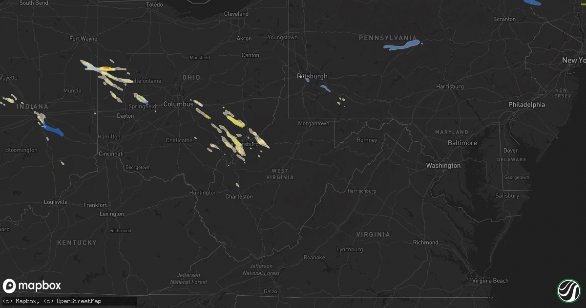
Hail Map in West Virginia on August 8, 2019
Get this storm
August 8 map
$229
one time, instant access
Download today. No call, no setup
Keep the $229
Bought the map and want the full workflow? Apply the entire $229 to a subscription within 7 days. None of it is wasted.
Every map, not just this one
This buys you this map. Subscription and you get every map we run, in the markets you choose from a few cities to whole states to nationwide. Plus real-time alerts the moment a storm fires.
Contact data
Name, contact info, occupancy, even credit band for addresses in the footprint. You go from where it hit to who to call.
Become the source they trust
Unlimited branding weather history reports on demand. You already have the documented answer ready for the property owner, and you are the one who showed up with it.
Property data and RoofTrace estimates
Pull up any address you have got, its value and the exact code rules for that jurisdiction, straight from One Click Code. Then RoofTrace estimates the squares, pitch, and roof value, priced the way you price.
Storm reports in West Virginia
West Virginia
| Date | Description |
|---|---|
| 08/08/20196:45 PM CDT | Trees down near intersection of dupont road and blannerhassett heights road. |
| 08/08/20196:10 PM CDT | Trees down on wolf run road. |
| 08/08/20195:50 PM CDT | Wood 911 reports trees and power lines down along riverview dr.... Murdock ave.... Emerson ave. Time estimated from radar. |
| 08/08/20194:45 PM CDT | Corrected source from previous tstm wnd dmg report from 1 nnw parkersburg. Tree down on powerline. Murdoch avenue temporarily closed. |
| 08/08/20194:45 PM CDT | Em reports numerous trees down at the intersection of davis run road and state route 74. Road is blocked. Time estimated from radar. |
| 08/08/20193:57 PM CDT | Multiple trees reported down near pullman rd. Time estimated from radar. |
| 08/08/20193:10 PM CDT | Trees reported down on turkey run. |
| 08/08/20193:00 PM CDT | Trees reported down on mount carmel ridge. |
| 08/08/20192:00 PM CDT | Trees down and damage to a hay shed reported. |
| 08/08/20191:48 PM CDT | There have been reports of numerous trees down |
| 08/08/20192:43 AM CDT | At 742 PM EDT, a severe thunderstorm was located near Coolville, moving southeast at 30 mph. HAZARD...60 mph wind gusts and quarter size hail. SOURCE...Radar indicated. IMPACT...Hail damage to vehicles is expected. Expect wind damage to roofs, siding, and trees. Locations impacted include... Parkersburg, Elizabeth, Coolville, Forked Run State Park, Washington, Mineralwells, Tuppers Plains, Lubeck, Peewee, Belleville, Reedsville, Palestine, Little Hocking, Blennerhassett, Greencastle, Morristown, Rockport and Leroy.This includes the following highways... Interstate 77 in West Virginia between mile markers 151 and 171. Route 50 in West Virginia between mile markers 1 and 3. |
| 08/08/20192:24 AM CDT | At 723 PM EDT, a severe thunderstorm was located near Elizabeth, moving southeast at 35 mph. HAZARD...60 mph wind gusts and quarter size hail. SOURCE...Radar indicated. IMPACT...Hail damage to vehicles is expected. Expect wind damage to roofs, siding, and trees. Locations impacted include... Spencer, Elizabeth, Reedy, Lucille, Cherry, Peewee, Creston, Morristown, Mount Zion, Annamoriah and Palestine. |
| 08/08/20192:07 AM CDT | At 707 PM EDT, a severe thunderstorm was located 8 miles east of Athens, moving southeast at 30 mph. HAZARD...60 mph wind gusts and quarter size hail. SOURCE...Radar indicated. IMPACT...Hail damage to vehicles is expected. Expect wind damage to roofs, siding, and trees. Locations impacted include... Parkersburg, Athens, Belpre, Coolville, Forked Run State Park, Washington, Tuppers Plains, Lubeck, Amesville, Belleville, Reedsville, Stroud Run State Park, Little Hocking, Blennerhassett and Bartlett.This includes the following highways... Interstate 77 in West Virginia between mile markers 171 and 174. Route 50 in West Virginia between mile markers 1 and 8. |
| 08/08/20191:42 AM CDT | At 642 PM EDT, a severe thunderstorm was located over Belpre, moving southeast at 30 mph. HAZARD...65 mph wind gusts and quarter size hail. SOURCE...Radar indicated. IMPACT...Hail damage to vehicles is expected. Expect wind damage to roofs, siding, and trees. Locations impacted include... Parkersburg, Belpre, Elizabeth, Vienna, Washington, Mineralwells, Lubeck, North Hills, Cairo, Peewee, Walker, Petroleum, Palestine, Little Hocking, Freeport, Blennerhassett, Davisville, Greencastle, Morristown and Rockport.This includes the following highways... Interstate 77 in West Virginia between mile markers 160 and 180. Route 50 in West Virginia between mile markers 1 and 22. |
| 08/08/20191:21 AM CDT | At 621 PM EDT, a severe thunderstorm was located 8 miles northwest of Glenville, moving southeast at 30 mph. HAZARD...60 mph wind gusts and quarter size hail. SOURCE...Radar indicated. IMPACT...Hail damage to vehicles is expected. Expect wind damage to roofs, siding, and trees. Locations impacted include... Glenville, Grantsville, Cedar Creek State Park, Burnsville, Sand Fork, Auburn, Shock, Wilsie, Baldwin, Rosedale, Stouts Mills, Sand Run, Troy, Exchange, Newberne, Coxs Mills, Linn, Big Springs, Stumptown and Tanner.This includes Interstate 79 between mile markers 74 and 86. |
| 08/08/20191:05 AM CDT | At 605 PM EDT, a severe thunderstorm was located over Chesterhill, moving southeast at 30 mph. HAZARD...60 mph wind gusts and quarter size hail. SOURCE...Radar indicated. IMPACT...Hail damage to vehicles is expected. Expect wind damage to roofs, siding, and trees. Locations impacted include... Parkersburg, Marietta, Belpre, Chesterhill, Vienna, Williamstown, Washington, Boaz, Lubeck, North Hills, Stockport, Little Hocking, Waverly, Fleming, Blennerhassett and Bartlett.This includes the following highways... Interstate 77 in West Virginia between mile markers 172 and 186. Route 50 in West Virginia between mile markers 1 and 11. |
| 08/08/201912:46 AM CDT | At 546 PM EDT, a severe thunderstorm was located 7 miles southwest of Wolfdale, or 8 miles northeast of Valley Grove, moving east at 35 mph. HAZARD...Wind gusts to 60 mph and quarter-size hail. SOURCE...Radar. IMPACT...Minor hail damage to vehicles is possible. Expect wind damage to trees and power lines, resulting in some power outages. Locations impacted include... Washington... Gastonville... Monessen... California... Donora... Monongahela... Charleroi... Wolfdale... McGovern... Bentleyville... Brownsville... East Washington...This includes the following highways... Interstate 70 in Pennsylvania between mile markers 0 and 43. Interstate 79 in Pennsylvania between mile markers 24 and 44. |
| 08/08/201912:22 AM CDT | At 522 PM EDT, a severe thunderstorm was located near North Bend State Park, or 7 miles southeast of St. Marys, moving southeast at 40 mph. HAZARD...60 mph wind gusts and quarter size hail. SOURCE...Radar indicated. IMPACT...Hail damage to vehicles is expected. Expect wind damage to roofs, siding, and trees. Locations impacted include... Harrisville, Pennsboro, North Bend State Park, Ellenboro, Cairo, Pullman, Auburn, Greenwood, Nutter Farm, Maxwell, Grove, Leopold, Schultz, Newberne, Pike, Coxs Mills, Berea, Tanner, Highland and Burnt House.This includes Route 50 in West Virginia between mile markers 26 and48. |
| 08/08/201912:05 AM CDT | At 504 PM EDT, a severe thunderstorm was located 10 miles northwest of Vienna, or 10 miles northwest of Belpre, moving southeast at 35 mph. HAZARD...60 mph wind gusts and quarter size hail. SOURCE...Radar indicated. IMPACT...Hail damage to vehicles is expected. Expect wind damage to roofs, siding, and trees. Locations impacted include... Parkersburg, Marietta, Belpre, Vienna, Williamstown, Washington, Mineralwells, Boaz, Lubeck, North Hills, Willow Island, Walker, Little Hocking, Schultz, Waverly, Fleming, Blennerhassett, Davisville and Bartlett.This includes the following highways... Interstate 77 in West Virginia between mile markers 166 and 186. Route 50 in West Virginia between mile markers 1 and 24. |
| 08/07/201911:29 PM CDT | At 429 PM EDT, a severe thunderstorm was located near Pennsboro, or 8 miles north of Harrisville, moving southeast at 30 mph. HAZARD...60 mph wind gusts and quarter size hail. SOURCE...Radar indicated. IMPACT...Hail damage to vehicles is expected. Expect wind damage to roofs, siding, and trees. Locations impacted include... Harrisville, Pennsboro, North Bend State Park, Ellenboro, Pullman, Auburn, Greenwood, Maxwell, Grove, Hebron, Pike, Berea and Highland.This includes Route 50 in West Virginia between mile markers 33 and51. |
| 08/07/201911:06 PM CDT | At 406 PM EDT, a severe thunderstorm was located near McConnelsville, moving southeast at 30 mph. HAZARD...60 mph wind gusts and quarter size hail. SOURCE...Radar indicated. IMPACT...Hail damage to vehicles is expected. Expect wind damage to roofs, siding, and trees. Locations impacted include... Marietta, McConnelsville, Beverly, Williamstown, Lowell, Bristol, Macksburg, Lower Salem, Hackney and Devola.This includes Interstate 77 in Ohio between mile markers 3 and 17. |
| 08/07/201911:01 PM CDT | At 401 PM EDT, severe thunderstorms were located along a line extending from Ohioville to near Calcutta to near Lisbon, moving southeast at 30 mph. HAZARD...Wind gusts to 60 mph and quarter-size hail. SOURCE...Radar. IMPACT...Minor hail damage to vehicles is possible. Expect wind damage to trees and power lines, resulting in some power outages. Locations impacted include... Pittsburgh... Ross Township... McCandless Township... Moon Township... Franklin Park... East Liverpool... Aliquippa... Monaca... Wellsville... Shaler Township... Plum... Hampton Township...This includes the following highways... Pennsylvania Turnpike between mile markers 46 and 48. Interstate 79 in Pennsylvania between mile markers 61 and 75. Interstate 376 in Pennsylvania between mile markers 35 and 59. |
All States Impacted by Hail Map on August 8, 2019
Cities Impacted by Hail Map on August 8, 2019
- Amelia, NE
- Taylor, NE
- Chambers, NE
- Burwell, NE
- Saint Marys, OH
- Celina, OH
- Racine, OH
- Springfield, OH
- Urbana, OH
- Saint Paris, OH
- Tremont City, OH
- Mcconnelsville, OH
- Oakdale, PA
- Hulett, WY
- Dexter City, OH
- Lowell, OH
- Coal Run, OH
- Macksburg, OH
- Beverly, OH
- Blue Rock, OH
- Caldwell, OH
- Guysville, OH
- Belleville, WV
- Reedsville, OH
- Stewart, OH
- Athens, OH
- Coolville, OH
- Amesville, OH
- Washington, WV
- Karval, CO
- Hugo, CO
- Arrowsmith, IL
- Bellflower, IL
- Saybrook, IL
- Hershey, NE
- Sutherland, NE
- North Vernon, IN
- Springfield, CO
- Two Buttes, CO
- Cameron, OK
- Poteau, OK
- Walsh, CO
- Saratoga Springs, NY
- Mechanicville, NY
- Parker, CO
- Bennett, CO
- Aurora, CO
- Palestine, WV
- Rockport, WV
- Elizabeth, WV
- Sandyville, WV
- Johnson, KS
- Richfield, KS
- Stella, NC
- Newport, NC
- Swansboro, NC
- Stapleton, NE
- Logan, NM
- Gillette, WY
- Amarillo, TX
- Mount Pleasant, SC
- Isle Of Palms, SC
- Bloomington, IL
- Downs, IL
- Elizabeth, CO
- Watkins, CO
- Ramah, CO
- Paxton, NE
- Coldwater, OH
- Indianapolis, IN
- Saint Henry, OH
- New Weston, OH
- Maria Stein, OH
- Curtis, NE
- Dickens, NE
- Maywood, NE
- Wellfleet, NE
- North Platte, NE
- Havelock, NC
- Moravia, NY
- Auburn, NY
- Simla, CO
- Matheson, CO
- Pomeroy, OH
- Mosquero, NM
- Clayton, NM
- Saint Marys, WV
- Ellenboro, WV
- Cairo, WV
- Somerset, PA
- Champion, PA
- Anna, OH
- Geneva, IN
- Sidney, OH
- Berne, IN
- Port Jefferson, OH
- Fort Recovery, OH
- Fort Loramie, OH
- Chickasaw, OH
- Maplewood, OH
- Bryant, IN
- Bluffton, IN
- Minster, OH
- Charleston, WV
- Buffalo, WY
- Raton, NM
- Capulin, NM
- San Jon, NM
- Crawfordsville, IN
- Elkhart, KS
- Las Animas, CO
- Arapahoe, NC
- Tyler, AL
- Beech Grove, IN
- New Matamoras, OH
- Newport, OH
- Marietta, OH
- Reno, OH
- Orient, OH
- Mcalester, OK
- Quinton, OK
- Stephentown, NY
- Alzada, MT
- New Salem, ND
- Hazen, ND
- Beulah, ND
- Broken Bow, NE
- Versailles, OH
- Yorkshire, OH
- Rossburg, OH
- New Ross, IN
- Conchas Dam, NM
- Patagonia, AZ
- Merna, NE
- Bismarck, IL
- Center, ND
- Buckeye Lake, OH
- Hebron, OH
- Pataskala, OH
- Granville, OH
- Whitman, NE
- Folsom, NM
- London, OH
- Georgetown, IL
- Vilas, CO
- Indianola, IL
- Imperial, PA
- Ridge Farm, IL
- Chrisman, IL
- Mineral Wells, WV
- Lanesborough, MA
- Williamstown, MA
- Sugar City, CO
- Covington, OH
- Pleasant Hill, OH
- Ludlow Falls, OH
- West Milton, OH
- Troy, OH
- Bradford, OH
- Williamstown, WV
- Harrisville, WV
- Pennsboro, WV
- Stinnett, TX
- Wendover, UT
- Merrimack, NH
- Parkersburg, WV
- Malta, OH
- Little Hocking, OH
- Corning, OH
- Cutler, OH
- Glouster, OH
- Chesterhill, OH
- Stockport, OH
- Vincent, OH
- Belpre, OH
- Greenwood, IN
- Beaufort, NC
- Covington, IN
- Williamsport, IN
- Big Pine, CA
- New Bern, NC
- Somerset, OH
- Junction City, OH
- Bremen, OH
- Rushville, OH
- Arthur, NE
- Olney Springs, CO
- Pearson, GA
- Maxwell, NE
- Millington, TN
- Memphis, TN
- Claude, TX
- Atlantic Beach, NC
- Maysville, NC
- Hubert, NC
- Salter Path, NC
- Emerald Isle, NC
- Le Roy, WV
- Hereford, TX
- New Market, IN
- Ladoga, IN
- Berlin, NY
- Mendon, OH
- Spencerville, OH
- Rockford, OH
- Rockwood, PA
- Pullman, WV
- Penfield, IL
- Attica, IN
- South Bloomingville, OH
- Petersburg, NY
- Canton, MS
- Opp, AL
- Kenvil, NJ
- Mine Hill, NJ
- Oklahoma City, OK
- Banks, AR
- Gabbs, NV
- Douglas, GA
- Gruver, TX
- Albany, OH
- Richmond, IN
- Blackshear, GA
- Wapakoneta, OH
- Botkins, OH
- Brady, NE
- Shade, OH
- Powell Butte, OR
- Smithville, WV
- Thornville, OH
- Ravenswood, WV
- Crescent, OK
- Marshall, IN
- Waveland, IN
- Dunning, NE
- Lebanon, IN
- Spencer, IN
- Luning, NV
- Kingman, IN
- Baltimore, OH
- Thurston, OH
- Millersport, OH
- Pleasantville, OH
- Ansonia, OH
- Greenville, OH
- Panhandle, TX
- Willacoochee, GA
- Nara Visa, NM
- Oriental, NC
- Lakeland, GA
- Wilkesville, OH
- Okemah, OK
- Waterford, NY
- Sullivans Island, SC
- Macfarlan, WV
- Hennessey, OK
- Yukon, OK
- Cumberland, OH
- Chandlersville, OH
- Philo, OH
- Ozark, AR
- Mulberry, AR
- Selma, AL
- Gettysburg, OH
- Foosland, IL
- Boone, CO
- Greeley, NE
- Kaycee, WY
- Chipley, FL
- Piedmont, OK
- Whipple, OH
- Schurz, NV
- Fort Morgan, CO
- Aliceville, AL
- Clifton Park, NY
- Ballston Lake, NY
- Danville, IL
- Alvin, IL
- State Line, IN
- Schaghticoke, NY
- Cohoes, NY
- Melrose, NY
- Kinston, AL
- Thorntown, IN
- Jamestown, IN
- Darlington, IN
- Mill Hall, PA
- Brewster, NE
- Whiteland, IN
- Edinburgh, IN
- Walker, WV
- Jet, OK
- New Straitsville, OH
- Shawnee, OH
- Spearman, TX
- Cheshire, MA
- Needham, IN
- Franklin, IN
- Trimble, OH
- Jacksonville, OH
- Rye, CO
- Walsenburg, CO
- Zanesville, OH
- Fleming, CO
- Manter, KS
- Prineville, OR
- Edgemont, SD
- Fleming, OH
- Okarche, OK
- Bend, OR
- Portland, IN
- New Bremen, OH
- Houston, OH
- Osgood, OH
- Russia, OH
- Piqua, OH
- Fairmount, IL
- Mershon, GA
- Hillsboro, IN
- Waynetown, IN
- Waverly, WV
- Mill Run, PA
- Normalville, PA
- Bridgeville, PA
- Carnegie, PA
- Bethel Park, PA
- Presto, PA
- Pittsburgh, PA
- Tarrs, PA
- Irwin, PA
- Mount Pleasant, PA
- Madison, PA
- Ruffs Dale, PA
- West Newton, PA
- Hunker, PA
- New Stanton, PA
- Herminie, PA
- Darragh, PA
- Julian, PA
- Milesburg, PA
- Howard, PA
- Philipsburg, PA
- Hawk Run, PA
- Morrisdale, PA
- Allport, PA
- Munson, PA
- West Decatur, PA
- Bellefonte, PA
- Wallaceton, PA
- Tyler Hill, PA
- Damascus, PA
- Lake Huntington, NY
- Callicoon, NY
- Swan Lake, NY
- Honesdale, PA
- Equinunk, PA
- Narrowsburg, NY
- Cochecton, NY
- Bethel, NY
- White Lake, NY
- Milanville, PA
- Waldron, IN
- Milroy, IN
- Shelbyville, IN
- Fairland, IN
- Manilla, IN
- Saint Paul, IN
- Boggstown, IN
- South Vienna, OH
- Muleshoe, TX
- Adams, MA
- Des Moines, NM
- Elba, NY
- Honeoye Falls, NY
- Oakfield, NY
- Bergen, NY
- Scottsville, NY
- Pavilion, NY
- Avon, NY
- Batavia, NY
- Byron, NY
- South Byron, NY
- Rush, NY
- Le Roy, NY
- Caledonia, NY
- Stafford, NY
- Branchport, NY
- Naples, NY
- Penn Yan, NY
- Keuka Park, NY
- Dundee, NY
- Watkins Glen, NY
- Bradford, NY
- Hector, NY
- Rock Stream, NY
- Hammondsport, NY
- Cohocton, NY
- Bath, NY
- Prattsburgh, NY
- Burdett, NY
- Avoca, NY
- Freeville, NY
- Groton, NY
- Lansing, NY
- Brooktondale, NY
- Richford, NY
- Dryden, NY
- Ithaca, NY
- Slaterville Springs, NY
- Van Etten, NY
- Owego, NY
- Newark Valley, NY
- Beaver Dams, NY
- Corning, NY
- Big Flats, NY
- Cayuta, NY
- Addison, NY
- Horseheads, NY
- Spencer, NY
- Breesport, NY
- Lockwood, NY
- Elmira, NY
- Campbell, NY
- Millport, NY
- Lowman, NY
- Painted Post, NY
- Candor, NY
- Erin, NY
- Pine Valley, NY
- Alpine, NY
- Willseyville, NY
- Montour Falls, NY
- Newfield, NY
- Binghamton, NY
- Castle Creek, NY
- Chenango Forks, NY
- Johnson City, NY
- Endicott, NY
- Kirkwood, NY
- Berkshire, NY
- Harpursville, NY
- Windsor, NY
- Maine, NY
- Ouaquaga, NY
- Port Crane, NY
- Glen Aubrey, NY
- Chemung, NY
- Waverly, NY
- Roseboom, NY
- Summit, NY
- New Lisbon, NY
- Morris, NY
- Jefferson, NY
- Otego, NY
- West Oneonta, NY
- Cooperstown, NY
- Schenevus, NY
- Oneonta, NY
- Charlotteville, NY
- Westford, NY
- Maryland, NY
- Mount Vision, NY
- South New Berlin, NY
- Edmeston, NY
- Burlington Flats, NY
- West Burlington, NY
- East Worcester, NY
- Portlandville, NY
- Worcester, NY
- Richmondville, NY
- Laurens, NY
- Garrattsville, NY
- Gilbertsville, NY
- Hartwick, NY
- Milford, NY
- New Berlin, NY
- Austerlitz, NY
- Huntington, MA
- Lee, MA
- Canaan, NY
- Hinsdale, MA
- Chester, MA
- Easthampton, MA
- West Stockbridge, MA
- Old Chatham, NY
- Stockbridge, MA
- Chatham, NY
- Lenox, MA
- Richmond, MA
- Valatie, NY
- Lenox Dale, MA
- Becket, MA
- Florence, MA
- East Chatham, NY
- Spencertown, NY
- Latham, NY
- Watervliet, NY
- Nephi, UT
- Vernon, UT
- Wappingers Falls, NY
- Poughkeepsie, NY
- Fallon, NV


