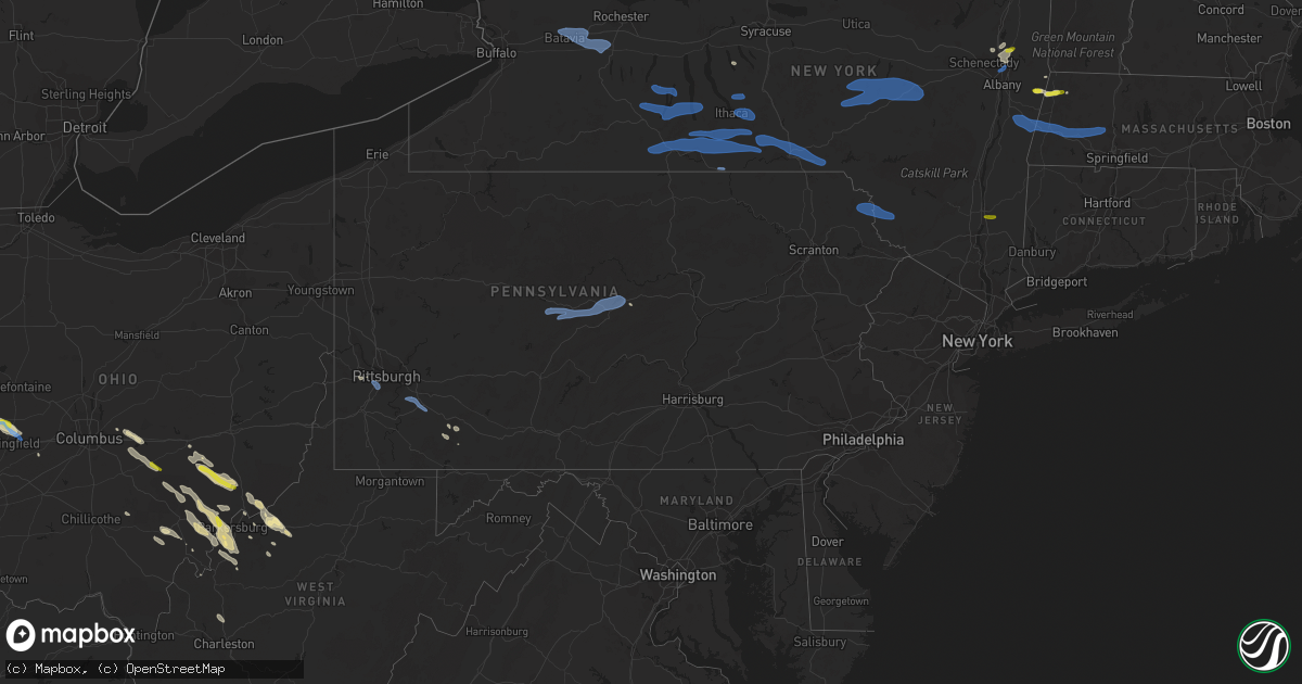
Hail Map in Pennsylvania on August 8, 2019
Get this storm
August 8 map
$229
one time, instant access
Download today. No call, no setup
Keep the $229
Bought the map and want the full workflow? Apply the entire $229 to a subscription within 7 days. None of it is wasted.
Every map, not just this one
This buys you this map. Subscription and you get every map we run, in the markets you choose from a few cities to whole states to nationwide. Plus real-time alerts the moment a storm fires.
Contact data
Name, contact info, occupancy, even credit band for addresses in the footprint. You go from where it hit to who to call.
Become the source they trust
Unlimited branding weather history reports on demand. You already have the documented answer ready for the property owner, and you are the one who showed up with it.
Property data and RoofTrace estimates
Pull up any address you have got, its value and the exact code rules for that jurisdiction, straight from One Click Code. Then RoofTrace estimates the squares, pitch, and roof value, priced the way you price.
Storm reports in Pennsylvania
Pennsylvania
| Date | Description |
|---|---|
| 08/08/20194:41 PM CDT | Trees and limbs down to the south and southeast of town |
| 08/08/20194:40 PM CDT | Tree down on brownstown rd. |
| 08/08/20194:37 PM CDT | Utility wires down on lock st |
| 08/08/20194:37 PM CDT | Trees down on mickanin rd |
| 08/08/20194:37 PM CDT | Reports of trees down on brokers lane |
| 08/08/20194:30 PM CDT | Reports of trees down on kalamazoo drive and highberger road |
| 08/08/20194:30 PM CDT | Utility wires reported down on ridge dr. |
| 08/08/20194:26 PM CDT | Tree and wires down at intersection of oliver and lincoln way |
| 08/08/20194:20 PM CDT | Tree down on main st. |
| 08/08/20194:11 PM CDT | Trees down. |
| 08/08/20194:10 PM CDT | Trees reported down on baldwin and mcmichael roads |
| 08/08/20194:05 PM CDT | Trees and wires down. |
| 08/08/20194:03 PM CDT | Large branches down |
| 08/08/20194:03 PM CDT | Trees down. |
| 08/08/20193:32 PM CDT | Numerous trees down blocking roadways. |
| 08/08/20193:18 PM CDT | Tree down on wires post pond rd. Tree down on jackson/park st. |
| 08/08/20191:18 PM CDT | Trees/wires down morris twp |
| 08/08/201912:41 AM CDT | At 541 PM EDT, a severe thunderstorm was located over New Stanton, or near Greensburg, moving southeast at 45 mph. HAZARD...Wind gusts to 60 mph. SOURCE...Radar. IMPACT...Expect damage to trees and power lines, resulting in some power outages. Locations impacted include... Greensburg... Jeannette... Connellsville... Mount Pleasant... Scottdale... Youngwood... West Newton... New Stanton... Seven Springs... Calumet-Norvelt... Everson... Penn...This includes the following highways... Interstate 70 in Pennsylvania between mile markers 48 and 57. Pennsylvania Turnpike between mile markers 68 and 99. |
| 08/08/201912:31 AM CDT | At 530 PM EDT, a severe thunderstorm was located over Lehigh, or 10 miles north of Mount Pocono, moving east at 35 mph. HAZARD...60 mph wind gusts and penny size hail. SOURCE...Radar indicated. IMPACT...Damage to roofs, siding, trees, and power lines is possible. Locations impacted include... Mount Pocono, Tobyhanna, Henryville, Echo Lake, Paradise Valley, Werry Lake, Gouldsboro State Park, Skytop, Mountainhome, Canadensis, Alpine Mountain and Cresco. |
| 08/08/201912:11 AM CDT | At 511 PM EDT, severe thunderstorms were located along a line extending from Livingston Manor to near Honesdale to near Bear Creek Village, moving east at 50 mph. HAZARD...60 mph wind gusts and penny size hail. SOURCE...Radar indicated. IMPACT...Expect damage to roofs, siding, and trees. Locations impacted include... Scranton, Wilkes-Barre, Falls, Dunmore, Kingston, Fallsburg, Plains, Carbondale, Port Jervis and Old Forge. |
| 08/07/201911:54 PM CDT | At 453 PM EDT, a severe thunderstorm was located over Imperial, or near Moon Township, moving southeast at 30 mph. HAZARD...Wind gusts to 60 mph. SOURCE...Radar. IMPACT...Expect damage to trees and power lines, resulting in some power outages. Locations impacted include... Pittsburgh... Mount Lebanon... Bethel Park... Moon Township... McMurray... McKeesport... Gastonville... West Mifflin... Baldwin... Upper St. Clair... Scott Township... Whitehall...This includes the following highways... Interstate 70 in Pennsylvania between mile markers 39 and 51. Pennsylvania Turnpike between mile markers 68 and 72. Interstate 79 in Pennsylvania between mile markers 48 and 66. Interstate 376 in Pennsylvania between mile markers 54 and 71. |
| 08/07/201911:26 PM CDT | At 425 PM EDT, severe thunderstorms were located along a line extending from near Hobart to near East Branch to near Gibson to Lovelton, moving east at 45 mph. HAZARD...60 mph wind gusts and penny size hail. SOURCE...Radar indicated. IMPACT...Expect damage to roofs, siding, and trees. Locations impacted include... Rockland, Scranton, Wilkes-Barre, Falls, Dunmore, Kingston, Fallsburg, Plains, Carbondale and Old Forge. |
| 08/07/20199:34 PM CDT | At 233 PM EDT, a severe thunderstorm was located over Black Moshannon State Park, moving east at 45 mph. This storm has a history of producing wind damage. HAZARD...60 mph wind gusts. SOURCE...Radar indicated. IMPACT...Expect damage to trees, roofs, and siding. Locations impacted include... Bellefonte, Pleasant Gap, Lamar, Lemont, Zion, Houserville, Centre Hall, Milesburg, Millheim, Blanchard, Aaronsburg, Port Matilda, Rebersburg, Spring Mills, Coburn, Madisonburg, Julian, Black Moshannon State Park, Bald Eagle State Park and Mackeyville.For those driving on Interstate 80, this includes areas between theKylertown and Loganton exits, specifically between mile markers 139and 145...and from mile markers 150 to 180.This includes Interstate 99 from mile markers 62 to 85. |
| 08/07/20199:02 PM CDT | At 202 PM EDT, a severe thunderstorm was located near Jeffries, moving east at 50 mph. HAZARD...60 mph wind gusts. SOURCE...Radar indicated. IMPACT...Expect damage to trees, roofs, and siding. Locations impacted include... Clearfield, Philipsburg, Woodland, Curwensville, Hyde, Osceola Mills, Plymptonville, Chester Hill, Karthaus, Snow Shoe, North Philipsburg, Clarence, South Philipsburg, Moshannon, Pine Glen, Jeffries, Lecontes Mills, Black Moshannon State Park, Morrisdale and West Decatur.For those driving on Interstate 80, this includes areas between thePenfield and Milesburg exits, specifically from mile markers 118 to149. |
All States Impacted by Hail Map on August 8, 2019
Cities Impacted by Hail Map on August 8, 2019
- Amelia, NE
- Taylor, NE
- Chambers, NE
- Burwell, NE
- Saint Marys, OH
- Celina, OH
- Racine, OH
- Springfield, OH
- Urbana, OH
- Saint Paris, OH
- Tremont City, OH
- Mcconnelsville, OH
- Oakdale, PA
- Hulett, WY
- Dexter City, OH
- Lowell, OH
- Coal Run, OH
- Macksburg, OH
- Beverly, OH
- Blue Rock, OH
- Caldwell, OH
- Guysville, OH
- Belleville, WV
- Reedsville, OH
- Stewart, OH
- Athens, OH
- Coolville, OH
- Amesville, OH
- Washington, WV
- Karval, CO
- Hugo, CO
- Arrowsmith, IL
- Bellflower, IL
- Saybrook, IL
- Hershey, NE
- Sutherland, NE
- North Vernon, IN
- Springfield, CO
- Two Buttes, CO
- Cameron, OK
- Poteau, OK
- Walsh, CO
- Saratoga Springs, NY
- Mechanicville, NY
- Parker, CO
- Bennett, CO
- Aurora, CO
- Palestine, WV
- Rockport, WV
- Elizabeth, WV
- Sandyville, WV
- Johnson, KS
- Richfield, KS
- Stella, NC
- Newport, NC
- Swansboro, NC
- Stapleton, NE
- Logan, NM
- Gillette, WY
- Amarillo, TX
- Mount Pleasant, SC
- Isle Of Palms, SC
- Bloomington, IL
- Downs, IL
- Elizabeth, CO
- Watkins, CO
- Ramah, CO
- Paxton, NE
- Coldwater, OH
- Indianapolis, IN
- Saint Henry, OH
- New Weston, OH
- Maria Stein, OH
- Curtis, NE
- Dickens, NE
- Maywood, NE
- Wellfleet, NE
- North Platte, NE
- Havelock, NC
- Moravia, NY
- Auburn, NY
- Simla, CO
- Matheson, CO
- Pomeroy, OH
- Mosquero, NM
- Clayton, NM
- Saint Marys, WV
- Ellenboro, WV
- Cairo, WV
- Somerset, PA
- Champion, PA
- Anna, OH
- Geneva, IN
- Sidney, OH
- Berne, IN
- Port Jefferson, OH
- Fort Recovery, OH
- Fort Loramie, OH
- Chickasaw, OH
- Maplewood, OH
- Bryant, IN
- Bluffton, IN
- Minster, OH
- Charleston, WV
- Buffalo, WY
- Raton, NM
- Capulin, NM
- San Jon, NM
- Crawfordsville, IN
- Elkhart, KS
- Las Animas, CO
- Arapahoe, NC
- Tyler, AL
- Beech Grove, IN
- New Matamoras, OH
- Newport, OH
- Marietta, OH
- Reno, OH
- Orient, OH
- Mcalester, OK
- Quinton, OK
- Stephentown, NY
- Alzada, MT
- New Salem, ND
- Hazen, ND
- Beulah, ND
- Broken Bow, NE
- Versailles, OH
- Yorkshire, OH
- Rossburg, OH
- New Ross, IN
- Conchas Dam, NM
- Patagonia, AZ
- Merna, NE
- Bismarck, IL
- Center, ND
- Buckeye Lake, OH
- Hebron, OH
- Pataskala, OH
- Granville, OH
- Whitman, NE
- Folsom, NM
- London, OH
- Georgetown, IL
- Vilas, CO
- Indianola, IL
- Imperial, PA
- Ridge Farm, IL
- Chrisman, IL
- Mineral Wells, WV
- Lanesborough, MA
- Williamstown, MA
- Sugar City, CO
- Covington, OH
- Pleasant Hill, OH
- Ludlow Falls, OH
- West Milton, OH
- Troy, OH
- Bradford, OH
- Williamstown, WV
- Harrisville, WV
- Pennsboro, WV
- Stinnett, TX
- Wendover, UT
- Merrimack, NH
- Parkersburg, WV
- Malta, OH
- Little Hocking, OH
- Corning, OH
- Cutler, OH
- Glouster, OH
- Chesterhill, OH
- Stockport, OH
- Vincent, OH
- Belpre, OH
- Greenwood, IN
- Beaufort, NC
- Covington, IN
- Williamsport, IN
- Big Pine, CA
- New Bern, NC
- Somerset, OH
- Junction City, OH
- Bremen, OH
- Rushville, OH
- Arthur, NE
- Olney Springs, CO
- Pearson, GA
- Maxwell, NE
- Millington, TN
- Memphis, TN
- Claude, TX
- Atlantic Beach, NC
- Maysville, NC
- Hubert, NC
- Salter Path, NC
- Emerald Isle, NC
- Le Roy, WV
- Hereford, TX
- New Market, IN
- Ladoga, IN
- Berlin, NY
- Mendon, OH
- Spencerville, OH
- Rockford, OH
- Rockwood, PA
- Pullman, WV
- Penfield, IL
- Attica, IN
- South Bloomingville, OH
- Petersburg, NY
- Canton, MS
- Opp, AL
- Kenvil, NJ
- Mine Hill, NJ
- Oklahoma City, OK
- Banks, AR
- Gabbs, NV
- Douglas, GA
- Gruver, TX
- Albany, OH
- Richmond, IN
- Blackshear, GA
- Wapakoneta, OH
- Botkins, OH
- Brady, NE
- Shade, OH
- Powell Butte, OR
- Smithville, WV
- Thornville, OH
- Ravenswood, WV
- Crescent, OK
- Marshall, IN
- Waveland, IN
- Dunning, NE
- Lebanon, IN
- Spencer, IN
- Luning, NV
- Kingman, IN
- Baltimore, OH
- Thurston, OH
- Millersport, OH
- Pleasantville, OH
- Ansonia, OH
- Greenville, OH
- Panhandle, TX
- Willacoochee, GA
- Nara Visa, NM
- Oriental, NC
- Lakeland, GA
- Wilkesville, OH
- Okemah, OK
- Waterford, NY
- Sullivans Island, SC
- Macfarlan, WV
- Hennessey, OK
- Yukon, OK
- Cumberland, OH
- Chandlersville, OH
- Philo, OH
- Ozark, AR
- Mulberry, AR
- Selma, AL
- Gettysburg, OH
- Foosland, IL
- Boone, CO
- Greeley, NE
- Kaycee, WY
- Chipley, FL
- Piedmont, OK
- Whipple, OH
- Schurz, NV
- Fort Morgan, CO
- Aliceville, AL
- Clifton Park, NY
- Ballston Lake, NY
- Danville, IL
- Alvin, IL
- State Line, IN
- Schaghticoke, NY
- Cohoes, NY
- Melrose, NY
- Kinston, AL
- Thorntown, IN
- Jamestown, IN
- Darlington, IN
- Mill Hall, PA
- Brewster, NE
- Whiteland, IN
- Edinburgh, IN
- Walker, WV
- Jet, OK
- New Straitsville, OH
- Shawnee, OH
- Spearman, TX
- Cheshire, MA
- Needham, IN
- Franklin, IN
- Trimble, OH
- Jacksonville, OH
- Rye, CO
- Walsenburg, CO
- Zanesville, OH
- Fleming, CO
- Manter, KS
- Prineville, OR
- Edgemont, SD
- Fleming, OH
- Okarche, OK
- Bend, OR
- Portland, IN
- New Bremen, OH
- Houston, OH
- Osgood, OH
- Russia, OH
- Piqua, OH
- Fairmount, IL
- Mershon, GA
- Hillsboro, IN
- Waynetown, IN
- Waverly, WV
- Mill Run, PA
- Normalville, PA
- Bridgeville, PA
- Carnegie, PA
- Bethel Park, PA
- Presto, PA
- Pittsburgh, PA
- Tarrs, PA
- Irwin, PA
- Mount Pleasant, PA
- Madison, PA
- Ruffs Dale, PA
- West Newton, PA
- Hunker, PA
- New Stanton, PA
- Herminie, PA
- Darragh, PA
- Julian, PA
- Milesburg, PA
- Howard, PA
- Philipsburg, PA
- Hawk Run, PA
- Morrisdale, PA
- Allport, PA
- Munson, PA
- West Decatur, PA
- Bellefonte, PA
- Wallaceton, PA
- Tyler Hill, PA
- Damascus, PA
- Lake Huntington, NY
- Callicoon, NY
- Swan Lake, NY
- Honesdale, PA
- Equinunk, PA
- Narrowsburg, NY
- Cochecton, NY
- Bethel, NY
- White Lake, NY
- Milanville, PA
- Waldron, IN
- Milroy, IN
- Shelbyville, IN
- Fairland, IN
- Manilla, IN
- Saint Paul, IN
- Boggstown, IN
- South Vienna, OH
- Muleshoe, TX
- Adams, MA
- Des Moines, NM
- Elba, NY
- Honeoye Falls, NY
- Oakfield, NY
- Bergen, NY
- Scottsville, NY
- Pavilion, NY
- Avon, NY
- Batavia, NY
- Byron, NY
- South Byron, NY
- Rush, NY
- Le Roy, NY
- Caledonia, NY
- Stafford, NY
- Branchport, NY
- Naples, NY
- Penn Yan, NY
- Keuka Park, NY
- Dundee, NY
- Watkins Glen, NY
- Bradford, NY
- Hector, NY
- Rock Stream, NY
- Hammondsport, NY
- Cohocton, NY
- Bath, NY
- Prattsburgh, NY
- Burdett, NY
- Avoca, NY
- Freeville, NY
- Groton, NY
- Lansing, NY
- Brooktondale, NY
- Richford, NY
- Dryden, NY
- Ithaca, NY
- Slaterville Springs, NY
- Van Etten, NY
- Owego, NY
- Newark Valley, NY
- Beaver Dams, NY
- Corning, NY
- Big Flats, NY
- Cayuta, NY
- Addison, NY
- Horseheads, NY
- Spencer, NY
- Breesport, NY
- Lockwood, NY
- Elmira, NY
- Campbell, NY
- Millport, NY
- Lowman, NY
- Painted Post, NY
- Candor, NY
- Erin, NY
- Pine Valley, NY
- Alpine, NY
- Willseyville, NY
- Montour Falls, NY
- Newfield, NY
- Binghamton, NY
- Castle Creek, NY
- Chenango Forks, NY
- Johnson City, NY
- Endicott, NY
- Kirkwood, NY
- Berkshire, NY
- Harpursville, NY
- Windsor, NY
- Maine, NY
- Ouaquaga, NY
- Port Crane, NY
- Glen Aubrey, NY
- Chemung, NY
- Waverly, NY
- Roseboom, NY
- Summit, NY
- New Lisbon, NY
- Morris, NY
- Jefferson, NY
- Otego, NY
- West Oneonta, NY
- Cooperstown, NY
- Schenevus, NY
- Oneonta, NY
- Charlotteville, NY
- Westford, NY
- Maryland, NY
- Mount Vision, NY
- South New Berlin, NY
- Edmeston, NY
- Burlington Flats, NY
- West Burlington, NY
- East Worcester, NY
- Portlandville, NY
- Worcester, NY
- Richmondville, NY
- Laurens, NY
- Garrattsville, NY
- Gilbertsville, NY
- Hartwick, NY
- Milford, NY
- New Berlin, NY
- Austerlitz, NY
- Huntington, MA
- Lee, MA
- Canaan, NY
- Hinsdale, MA
- Chester, MA
- Easthampton, MA
- West Stockbridge, MA
- Old Chatham, NY
- Stockbridge, MA
- Chatham, NY
- Lenox, MA
- Richmond, MA
- Valatie, NY
- Lenox Dale, MA
- Becket, MA
- Florence, MA
- East Chatham, NY
- Spencertown, NY
- Latham, NY
- Watervliet, NY
- Nephi, UT
- Vernon, UT
- Wappingers Falls, NY
- Poughkeepsie, NY
- Fallon, NV


