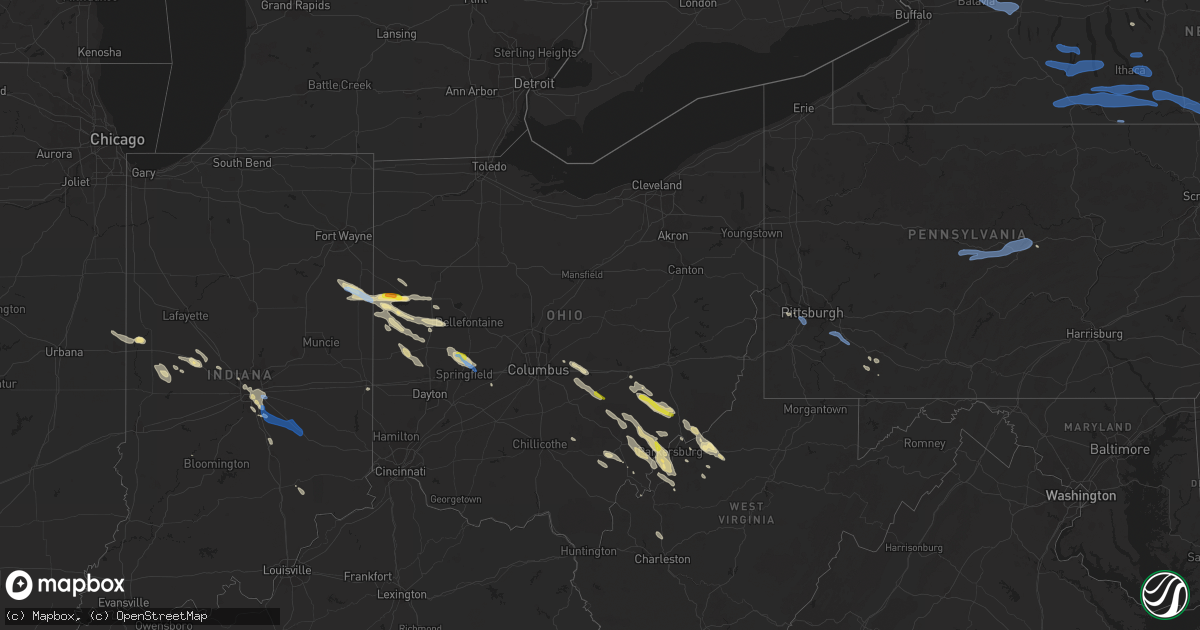
Hail Map in Ohio on August 8, 2019
Get this storm
August 8 map
$229
one time, instant access
Download today. No call, no setup
Keep the $229
Bought the map and want the full workflow? Apply the entire $229 to a subscription within 7 days. None of it is wasted.
Every map, not just this one
This buys you this map. Subscription and you get every map we run, in the markets you choose from a few cities to whole states to nationwide. Plus real-time alerts the moment a storm fires.
Contact data
Name, contact info, occupancy, even credit band for addresses in the footprint. You go from where it hit to who to call.
Become the source they trust
Unlimited branding weather history reports on demand. You already have the documented answer ready for the property owner, and you are the one who showed up with it.
Property data and RoofTrace estimates
Pull up any address you have got, its value and the exact code rules for that jurisdiction, straight from One Click Code. Then RoofTrace estimates the squares, pitch, and roof value, priced the way you price.
Storm reports in Ohio
Ohio
| Date | Description |
|---|---|
| 08/08/20196:38 PM CDT | Athens 911 reports trees and power lines down in the coolville area. Time estimated from radar. |
| 08/08/20196:30 PM CDT | Large... Healthy apple tree came down along with a section of fence. Via facebook with pictures. Time estimated via radar. |
| 08/08/20196:04 PM CDT | Small limb downed in circleville. Time estimated by radar. |
| 08/08/20196:01 PM CDT | *** 1 inj *** tree fell onto vehicle along northridge road near nicholas road. 1 serious injury reported. Time estimated by radar. |
| 08/08/20195:52 PM CDT | Athens 911 reports trees and power lines down... As well as a porch roof removed near the post office. Time estimated from radar. |
| 08/08/20195:49 PM CDT | Numerous trees... Tree limbs... And powerlines downed in the choctaw lake area. Time estimated by radar. |
| 08/08/20195:46 PM CDT | Athens 911 reports trees and power lines down in the glouster area. Time estimated from radar. |
| 08/08/20195:27 PM CDT | Trees and powerlines downed along a portion of mechanicsburg road. Time estimated by radar. |
| 08/08/20195:27 PM CDT | Trees and powerlines downed in the german township area. Time estimated by radar. |
| 08/08/20195:24 PM CDT | Trees downed along moorefield ct and throughout the neighborhood. Time of event estimated. |
| 08/08/20195:21 PM CDT | Tree downed along a portion of sr 55 near champaign and clark county line. Time estimated by radar. Lsr corrected for location. |
| 08/08/20195:21 PM CDT | Tree downed along a portion of sr 560 near champaign and clark county line. Time estimated by radar. |
| 08/08/20195:21 PM CDT | Tree downed along a portion of sr 55 near champaign and clark county line. Time estimated by radar. |
| 08/08/20195:15 PM CDT | Tree down and blocking sr 339 in both directions at mile marker 10.2 near sr 550. |
| 08/08/20195:05 PM CDT | Numerous trees down blocking county road 80 outside of chesterhill. |
| 08/08/20194:46 PM CDT | Some lights and signs were damaged on a few buildings along us 127 n. Time estimated from radar. |
| 08/08/20194:44 PM CDT | Time estimated by radar. |
| 08/08/20194:44 PM CDT | Healthy tree of unknown size downed on a vehicle along s. Miami ave. Time estimated by radar. |
| 08/08/20194:43 PM CDT | Trees downed. |
| 08/08/20194:25 PM CDT | A few trees downed in the minster area. Time estimated from radar. |
| 08/08/20194:16 PM CDT | Part of a tree was downed along with several limbs from other trees. Time estimated from radar. |
| 08/08/20194:15 PM CDT | Pictures from a farm showing multiple trees down and stripped. Roof damage to barn. Time estimated from radar. |
| 08/08/20194:07 PM CDT | Trees and power lines down reported in the vanfossen ln. Area west of chester hill. Time estimated from radar. |
| 08/08/20194:06 PM CDT | Trees and power lines down along wood rd. Near chester hill. Time estimated from radar. |
| 08/08/20194:01 PM CDT | Trees downed. |
| 08/08/20193:57 PM CDT | Perry 911 reports a camper flipped and carport flipped in the pen road area of junction. Time estimated from radar. |
| 08/08/20193:44 PM CDT | Numerous trees and powerlines downed in the buckeye lake area. Time estimated by radar. |
| 08/08/20193:42 PM CDT | Large tree downed along a portion of high st. South of us 40. Time estimated by radar. |
| 08/08/20193:42 PM CDT | Large tree downed near intersection of 9th ave and north st. Time estimated by radar. |
| 08/08/20193:35 PM CDT | Branches approximately four inches at the base were broken off the top of a silver maple... And were strewn across a ten foot wide driveway. |
| 08/08/20193:35 PM CDT | Several trees down in the area |
| 08/08/20193:35 PM CDT | A local report indicates 1.00 inch wind near 2 S DUNGANNON |
| 08/08/20193:33 PM CDT | Numerous trees and powerlines downed in pataskala. Time estimated by radar. |
| 08/08/20193:30 PM CDT | Several medium sized trees snapped to the ground. |
| 08/08/20193:20 PM CDT | A thirty foot tall tree was snapped off at its base. |
| 08/08/20193:18 PM CDT | Limbs down in residential yard |
| 08/08/20193:15 PM CDT | Washington co. 911 reports multiple trees and power lines down in the lowell area. Time estimated from radar. |
| 08/08/20193:11 PM CDT | Trees and power lines down in the old somerset rd. Area. Time estimated from radar. |
| 08/08/20193:02 PM CDT | Hail size estimated with coin. Also tree limbs and power lines down. |
| 08/08/20192:48 PM CDT | A tree fell onto a road. Time esimated from radar. |
| 08/08/20197:09 AM CDT | At 1209 PM EDT, a severe thunderstorm was located near Centerburg, or 11 miles southwest of Mount Vernon, moving southeast at 40 mph. HAZARD...60 mph wind gusts and quarter size hail. SOURCE...Radar indicated. IMPACT...Minor damage to vehicles is possible. Expect damage to trees and power lines. Locations impacted include... Utica and Centerburg. |
| 08/08/20196:26 AM CDT | At 1125 PM EDT, a severe thunderstorm was located near Huber Heights, moving east at 45 mph. HAZARD...60 mph wind gusts and nickel size hail. SOURCE...Radar indicated. IMPACT...Expect damage to trees and power lines. Locations impacted include... Dayton, Huber Heights, Fairborn, Yellow Springs, Wright-Patterson Afb, Cedarville, Enon, Wilberforce, Riverside, Clifton, Green Meadows, Medway, Springfield Municipal Airport, Hustead, Holiday Valley, John Bryan State Park, Snyderville, Selma, Crystal Lakes and Pitchin.This includes I-70 in Ohio between mile markers 37 and 51. |
| 08/08/20195:50 AM CDT | At 1050 PM EDT, a severe thunderstorm was located over Pleasant Hill, moving east at 45 mph. HAZARD...60 mph wind gusts and quarter size hail. SOURCE...Radar indicated. IMPACT...Minor hail damage to vehicles is possible. Expect wind damage to trees and power lines. Locations impacted include... Huber Heights, Troy, Piqua, Vandalia, Tipp City, New Carlisle, West Milton, Covington, Enon, Pleasant Hill, Brown, Christiansburg, North Hampton, Laura, Donnelsville, Casstown, Ludlow Falls, Green Meadows, Ginghamsburg and Thackery.This includes the following Interstates... I-70 in Ohio between mile markers 43 and 48. I-75 in Ohio between mile markers 66 and 80. |
| 08/08/20193:58 AM CDT | At 858 PM EDT, a severe thunderstorm was located near De Graff, moving east at 40 mph. HAZARD...60 mph wind gusts and quarter size hail. SOURCE...Radar indicated. IMPACT...Minor hail damage to vehicles is possible. Expect wind damage to trees and power lines. Locations impacted include... Bellefontaine, West Liberty, De Graff, Quincy, Port Jefferson, Mcmorran, Maplewood, Logansville and Pemberton. |
| 08/08/20193:27 AM CDT | At 827 PM EDT, a severe thunderstorm was located near Piqua, moving southeast at 30 mph. HAZARD...60 mph wind gusts and quarter size hail. SOURCE...Radar indicated. IMPACT...Minor hail damage to vehicles is possible. Expect wind damage to trees and power lines. Locations impacted include... Troy, Sidney, Piqua, New Carlisle, St. Paris, Brown, Hardin, Christiansburg, North Hampton, Fletcher, Casstown, Lockington, Thackery, Westville, Newbern, Haven View, Ballou, Farrington, Terre Haute and State Route 41 at State Route 235.This includes I-75 in Ohio between mile markers 78 and 90. |
| 08/08/20193:13 AM CDT | At 812 PM EDT, a severe thunderstorm was located near Coldwater, moving east at 40 mph. HAZARD...60 mph wind gusts and quarter size hail. SOURCE...Radar indicated. IMPACT...Minor hail damage to vehicles is possible. Expect wind damage to trees and power lines. Locations impacted include... Celina, St. Marys, New Knoxville, Moulton, Wabash, Buckland, Neptune, State Route 116 at State Route 197, Bulkhead and Tama. |
| 08/08/20192:50 AM CDT | At 749 PM EDT, a severe thunderstorm was located near St. Henry, moving southeast at 30 mph. HAZARD...60 mph wind gusts and quarter size hail. SOURCE...Radar indicated. IMPACT...Minor hail damage to vehicles is possible. Expect wind damage to trees and power lines. Locations impacted include... Piqua, Versailles, Covington, Newport, Bradford, Pleasant Hill, Webster, Russia, Osgood, North Star, Rossburg, Lockington, New Weston, Yorkshire, Polo, Newbern, Darke County Airport, State Route 47 at US Route 127, Eldora Speedway and Willowdell.This includes I-75 in Ohio between mile markers 78 and 88. |
| 08/08/20191:18 AM CDT | At 617 PM EDT, a severe thunderstorm was located near Urbana, moving southeast at 35 mph. HAZARD...60 mph wind gusts and nickel size hail. SOURCE...Radar indicated. IMPACT...Expect damage to trees and power lines. Locations impacted include... Springfield, Urbana, London, South Charleston, Choctaw Lake, Harmony, Lisbon, Brighton, Lafayette, South Vienna, Tremont City, Midway, Catawba, Newport, Thackery, Westville, Powhattan, Catawba Station, Terre Haute and Madison Lake.Those attending Champaign County Fair are in the path of this storm and should prepare for IMMINENT DANGEROUS WEATHER CONDITIONS. SEEK SHELTER NOW!This includes the following Interstates... I-70 in Ohio between mile markers 59 and 78. I-71 in Ohio near mile marker 76. |
| 08/08/201912:55 AM CDT | At 555 PM EDT, a severe thunderstorm was located near Trotwood, moving east at 40 mph. HAZARD...60 mph wind gusts and penny size hail. SOURCE...Radar indicated. IMPACT...Expect damage to trees and power lines. Locations impacted include... Dayton, Kettering, Beavercreek, Huber Heights, Fairborn, Xenia, Trotwood, Vandalia, Moraine, Oakwood, Yellow Springs, Wright-Patterson Afb, Cedarville, Enon, Wilberforce, Riverside, Clayton, New Lebanon, Shiloh and Clifton.This includes the following Interstates... I-70 in Ohio between mile markers 43 and 44. I-75 in Ohio between mile markers 50 and 59. |
| 08/08/201912:49 AM CDT | At 549 PM EDT, a severe thunderstorm was located over Pleasant Hill, moving east at 35 mph. HAZARD...60 mph wind gusts and penny size hail. SOURCE...Radar indicated. IMPACT...Expect damage to trees and power lines. Locations impacted include... Troy, Piqua, Tipp City, New Carlisle, Covington, Pleasant Hill, Brown, Christiansburg, North Hampton, Donnelsville, Casstown, Ludlow Falls, Thackery, Haven View, Circle Hill, Farrington, State Route 41 at State Route 235, Grayson and Dialton.This includes the following Interstates... I-70 in Ohio near mile marker 47. I-75 in Ohio between mile markers 68 and 79. |
| 08/08/201912:15 AM CDT | At 515 PM EDT, a severe thunderstorm was located near Minster, moving southeast at 40 mph. HAZARD...60 mph wind gusts. SOURCE...Radar indicated. IMPACT...Expect damage to trees and power lines. Locations impacted include... Sidney, New Bremen, Minster, Newport, Anna, Fort Loramie, Hardin, Port Jefferson, Osgood, Lockington, Newbern, Egypt, Lake Loramie State Park, Ballou, Plattsville, Mccartyville, Swanders, Pemberton and Houston.This includes I-75 in Ohio between mile markers 86 and 99. |
| 08/08/201912:03 AM CDT | At 503 PM EDT, a severe thunderstorm was located near South Zanesville, or near Zanesville, moving southeast at 30 mph. HAZARD...Wind gusts to 60 mph. SOURCE...Radar. IMPACT...Expect damage to trees and power lines, resulting in some power outages. Locations impacted include... Zanesville... South Zanesville... Philo... Fultonham... Ruraldale... Cannelville... High Hill... Duncan Falls... East Fultonham... Blue Rock State Park...This includes Interstate 70 in Ohio between mile markers 152 and153. |
| 08/07/201911:45 PM CDT | At 445 PM EDT, a severe thunderstorm was located over Geneva, moving southeast at 35 mph. HAZARD...60 mph wind gusts. SOURCE...Radar indicated. IMPACT...Expect damage to trees and power lines. Locations impacted include... Celina, Coldwater, St. Henry, Fort Recovery, Wabash, Chickasaw, Burkettsville, Montezuma, Carthagena and Maria Stein. |
| 08/07/201911:36 PM CDT | At 436 PM EDT, a severe thunderstorm was located over Thornport, or 7 miles south of Heath, moving southeast at 45 mph. HAZARD...60 mph wind gusts and quarter size hail. SOURCE...Radar indicated. IMPACT...Hail damage to vehicles is expected. Expect wind damage to roofs, siding, and trees. Locations impacted include... New Lexington, Somerset, Shawnee, Perry State Forest, Crooksville, Thornville, Junction City, New Straitsville, Glenford, Hemlock, Rendville and Eagleport. |
| 08/07/201911:33 PM CDT | At 433 PM EDT, a severe thunderstorm was located near Geneva, or near Berne, moving southeast at 35 mph. HAZARD...60 mph wind gusts and penny size hail. SOURCE...Radar indicated. IMPACT...Expect damage to roofs, siding, and trees. Locations impacted include... Berne, Geneva, Westchester, Nottingham, Bryant, Trinity, Linn Grove, Domestic, New Corydon, Ceylon, Petroleum and Bellfountain. |
| 08/07/201911:33 PM CDT | At 433 PM EDT, a severe thunderstorm was located over Shawnee, moving southeast at 30 mph. HAZARD...60 mph wind gusts and quarter size hail. SOURCE...Radar indicated. IMPACT...Hail damage to vehicles is expected. Expect wind damage to roofs, siding, and trees. Locations impacted include... Glouster, Shawnee, Chesterhill, New Straitsville, Corning, Jacksonville, Trimble, Hemlock, Amesville, Rendville, Stroud Run State Park and Burr Oak State Park. |
| 08/07/201911:29 PM CDT | At 429 PM EDT, a severe thunderstorm was located near Beverly, moving southeast at 35 mph. HAZARD...Wind gusts to 60 mph and quarter-size hail. SOURCE...Radar. IMPACT...Minor hail damage to vehicles is possible. Expect wind damage to trees and power lines, resulting in some power outages. Locations impacted include... Dudley... Dexter City... Harriettsville... This includes Interstate 77 in Ohio between mile markers 18 and 21. |
| 08/07/201910:54 PM CDT | At 353 PM EDT, a severe thunderstorm was located near St. Marys, moving southeast at 25 mph. HAZARD...60 mph wind gusts and quarter size hail. SOURCE...Radar indicated. IMPACT...Hail damage to vehicles is expected. Expect wind damage to roofs, siding, and trees. Locations impacted include... Harrisville, St. Marys, Pennsboro, Belmont, Newport, Ellenboro, Maxwell, Arvilla, Point Lookout, Wick, Mountain, Hebron, Pike and Highland.This includes Route 50 in West Virginia between mile markers 32 and41. |
| 08/07/201910:48 PM CDT | At 347 PM EDT, a severe thunderstorm was located near Bremen, or near Somerset, moving southeast at 30 mph. HAZARD...60 mph wind gusts and quarter size hail. SOURCE...Radar indicated. IMPACT...Hail damage to vehicles is expected. Expect wind damage to roofs, siding, and trees. Locations impacted include... New Lexington, Somerset, Shawnee, Perry State Forest, Crooksville, Junction City, New Straitsville, Corning, Hemlock and Rendville. |
| 08/07/201910:46 PM CDT | At 345 PM EDT, a severe thunderstorm was located 8 miles south of New Concord, or 13 miles southwest of Cambridge, moving east at 45 mph. HAZARD...Wind gusts to 60 mph. SOURCE...Radar. IMPACT...Expect damage to trees and power lines, resulting in some power outages. Locations impacted include... Caldwell... New Concord... Dudley... Senecaville... Pleasant City... Cumberland... Summerfield... Belle Valley... Lewisville... Sarahsville... Norwich... High Hill...This includes the following highways... Interstate 70 in Ohio between mile markers 166 and 170. Interstate 77 in Ohio between mile markers 21 and 40. |
| 08/07/201910:07 PM CDT | Tree reported down at the intersection of oh-571 and worley rd. Time estimated from radar. |
| 08/07/20199:26 PM CDT | Trees and power lines reported down. Barn destroyed. Damage to grain silos. Time estimated from radar. |
| 08/07/20197:25 PM CDT | Several limbs downed on the north side of celina. Also... Some field tile removed from an unknown type structure. Time estimated by radar. |
| 08/07/20197:25 PM CDT | Time estimated by radar. |
All States Impacted by Hail Map on August 8, 2019
Cities Impacted by Hail Map on August 8, 2019
- Amelia, NE
- Taylor, NE
- Chambers, NE
- Burwell, NE
- Saint Marys, OH
- Celina, OH
- Racine, OH
- Springfield, OH
- Urbana, OH
- Saint Paris, OH
- Tremont City, OH
- Mcconnelsville, OH
- Oakdale, PA
- Hulett, WY
- Dexter City, OH
- Lowell, OH
- Coal Run, OH
- Macksburg, OH
- Beverly, OH
- Blue Rock, OH
- Caldwell, OH
- Guysville, OH
- Belleville, WV
- Reedsville, OH
- Stewart, OH
- Athens, OH
- Coolville, OH
- Amesville, OH
- Washington, WV
- Karval, CO
- Hugo, CO
- Arrowsmith, IL
- Bellflower, IL
- Saybrook, IL
- Hershey, NE
- Sutherland, NE
- North Vernon, IN
- Springfield, CO
- Two Buttes, CO
- Cameron, OK
- Poteau, OK
- Walsh, CO
- Saratoga Springs, NY
- Mechanicville, NY
- Parker, CO
- Bennett, CO
- Aurora, CO
- Palestine, WV
- Rockport, WV
- Elizabeth, WV
- Sandyville, WV
- Johnson, KS
- Richfield, KS
- Stella, NC
- Newport, NC
- Swansboro, NC
- Stapleton, NE
- Logan, NM
- Gillette, WY
- Amarillo, TX
- Mount Pleasant, SC
- Isle Of Palms, SC
- Bloomington, IL
- Downs, IL
- Elizabeth, CO
- Watkins, CO
- Ramah, CO
- Paxton, NE
- Coldwater, OH
- Indianapolis, IN
- Saint Henry, OH
- New Weston, OH
- Maria Stein, OH
- Curtis, NE
- Dickens, NE
- Maywood, NE
- Wellfleet, NE
- North Platte, NE
- Havelock, NC
- Moravia, NY
- Auburn, NY
- Simla, CO
- Matheson, CO
- Pomeroy, OH
- Mosquero, NM
- Clayton, NM
- Saint Marys, WV
- Ellenboro, WV
- Cairo, WV
- Somerset, PA
- Champion, PA
- Anna, OH
- Geneva, IN
- Sidney, OH
- Berne, IN
- Port Jefferson, OH
- Fort Recovery, OH
- Fort Loramie, OH
- Chickasaw, OH
- Maplewood, OH
- Bryant, IN
- Bluffton, IN
- Minster, OH
- Charleston, WV
- Buffalo, WY
- Raton, NM
- Capulin, NM
- San Jon, NM
- Crawfordsville, IN
- Elkhart, KS
- Las Animas, CO
- Arapahoe, NC
- Tyler, AL
- Beech Grove, IN
- New Matamoras, OH
- Newport, OH
- Marietta, OH
- Reno, OH
- Orient, OH
- Mcalester, OK
- Quinton, OK
- Stephentown, NY
- Alzada, MT
- New Salem, ND
- Hazen, ND
- Beulah, ND
- Broken Bow, NE
- Versailles, OH
- Yorkshire, OH
- Rossburg, OH
- New Ross, IN
- Conchas Dam, NM
- Patagonia, AZ
- Merna, NE
- Bismarck, IL
- Center, ND
- Buckeye Lake, OH
- Hebron, OH
- Pataskala, OH
- Granville, OH
- Whitman, NE
- Folsom, NM
- London, OH
- Georgetown, IL
- Vilas, CO
- Indianola, IL
- Imperial, PA
- Ridge Farm, IL
- Chrisman, IL
- Mineral Wells, WV
- Lanesborough, MA
- Williamstown, MA
- Sugar City, CO
- Covington, OH
- Pleasant Hill, OH
- Ludlow Falls, OH
- West Milton, OH
- Troy, OH
- Bradford, OH
- Williamstown, WV
- Harrisville, WV
- Pennsboro, WV
- Stinnett, TX
- Wendover, UT
- Merrimack, NH
- Parkersburg, WV
- Malta, OH
- Little Hocking, OH
- Corning, OH
- Cutler, OH
- Glouster, OH
- Chesterhill, OH
- Stockport, OH
- Vincent, OH
- Belpre, OH
- Greenwood, IN
- Beaufort, NC
- Covington, IN
- Williamsport, IN
- Big Pine, CA
- New Bern, NC
- Somerset, OH
- Junction City, OH
- Bremen, OH
- Rushville, OH
- Arthur, NE
- Olney Springs, CO
- Pearson, GA
- Maxwell, NE
- Millington, TN
- Memphis, TN
- Claude, TX
- Atlantic Beach, NC
- Maysville, NC
- Hubert, NC
- Salter Path, NC
- Emerald Isle, NC
- Le Roy, WV
- Hereford, TX
- New Market, IN
- Ladoga, IN
- Berlin, NY
- Mendon, OH
- Spencerville, OH
- Rockford, OH
- Rockwood, PA
- Pullman, WV
- Penfield, IL
- Attica, IN
- South Bloomingville, OH
- Petersburg, NY
- Canton, MS
- Opp, AL
- Kenvil, NJ
- Mine Hill, NJ
- Oklahoma City, OK
- Banks, AR
- Gabbs, NV
- Douglas, GA
- Gruver, TX
- Albany, OH
- Richmond, IN
- Blackshear, GA
- Wapakoneta, OH
- Botkins, OH
- Brady, NE
- Shade, OH
- Powell Butte, OR
- Smithville, WV
- Thornville, OH
- Ravenswood, WV
- Crescent, OK
- Marshall, IN
- Waveland, IN
- Dunning, NE
- Lebanon, IN
- Spencer, IN
- Luning, NV
- Kingman, IN
- Baltimore, OH
- Thurston, OH
- Millersport, OH
- Pleasantville, OH
- Ansonia, OH
- Greenville, OH
- Panhandle, TX
- Willacoochee, GA
- Nara Visa, NM
- Oriental, NC
- Lakeland, GA
- Wilkesville, OH
- Okemah, OK
- Waterford, NY
- Sullivans Island, SC
- Macfarlan, WV
- Hennessey, OK
- Yukon, OK
- Cumberland, OH
- Chandlersville, OH
- Philo, OH
- Ozark, AR
- Mulberry, AR
- Selma, AL
- Gettysburg, OH
- Foosland, IL
- Boone, CO
- Greeley, NE
- Kaycee, WY
- Chipley, FL
- Piedmont, OK
- Whipple, OH
- Schurz, NV
- Fort Morgan, CO
- Aliceville, AL
- Clifton Park, NY
- Ballston Lake, NY
- Danville, IL
- Alvin, IL
- State Line, IN
- Schaghticoke, NY
- Cohoes, NY
- Melrose, NY
- Kinston, AL
- Thorntown, IN
- Jamestown, IN
- Darlington, IN
- Mill Hall, PA
- Brewster, NE
- Whiteland, IN
- Edinburgh, IN
- Walker, WV
- Jet, OK
- New Straitsville, OH
- Shawnee, OH
- Spearman, TX
- Cheshire, MA
- Needham, IN
- Franklin, IN
- Trimble, OH
- Jacksonville, OH
- Rye, CO
- Walsenburg, CO
- Zanesville, OH
- Fleming, CO
- Manter, KS
- Prineville, OR
- Edgemont, SD
- Fleming, OH
- Okarche, OK
- Bend, OR
- Portland, IN
- New Bremen, OH
- Houston, OH
- Osgood, OH
- Russia, OH
- Piqua, OH
- Fairmount, IL
- Mershon, GA
- Hillsboro, IN
- Waynetown, IN
- Waverly, WV
- Mill Run, PA
- Normalville, PA
- Bridgeville, PA
- Carnegie, PA
- Bethel Park, PA
- Presto, PA
- Pittsburgh, PA
- Tarrs, PA
- Irwin, PA
- Mount Pleasant, PA
- Madison, PA
- Ruffs Dale, PA
- West Newton, PA
- Hunker, PA
- New Stanton, PA
- Herminie, PA
- Darragh, PA
- Julian, PA
- Milesburg, PA
- Howard, PA
- Philipsburg, PA
- Hawk Run, PA
- Morrisdale, PA
- Allport, PA
- Munson, PA
- West Decatur, PA
- Bellefonte, PA
- Wallaceton, PA
- Tyler Hill, PA
- Damascus, PA
- Lake Huntington, NY
- Callicoon, NY
- Swan Lake, NY
- Honesdale, PA
- Equinunk, PA
- Narrowsburg, NY
- Cochecton, NY
- Bethel, NY
- White Lake, NY
- Milanville, PA
- Waldron, IN
- Milroy, IN
- Shelbyville, IN
- Fairland, IN
- Manilla, IN
- Saint Paul, IN
- Boggstown, IN
- South Vienna, OH
- Muleshoe, TX
- Adams, MA
- Des Moines, NM
- Elba, NY
- Honeoye Falls, NY
- Oakfield, NY
- Bergen, NY
- Scottsville, NY
- Pavilion, NY
- Avon, NY
- Batavia, NY
- Byron, NY
- South Byron, NY
- Rush, NY
- Le Roy, NY
- Caledonia, NY
- Stafford, NY
- Branchport, NY
- Naples, NY
- Penn Yan, NY
- Keuka Park, NY
- Dundee, NY
- Watkins Glen, NY
- Bradford, NY
- Hector, NY
- Rock Stream, NY
- Hammondsport, NY
- Cohocton, NY
- Bath, NY
- Prattsburgh, NY
- Burdett, NY
- Avoca, NY
- Freeville, NY
- Groton, NY
- Lansing, NY
- Brooktondale, NY
- Richford, NY
- Dryden, NY
- Ithaca, NY
- Slaterville Springs, NY
- Van Etten, NY
- Owego, NY
- Newark Valley, NY
- Beaver Dams, NY
- Corning, NY
- Big Flats, NY
- Cayuta, NY
- Addison, NY
- Horseheads, NY
- Spencer, NY
- Breesport, NY
- Lockwood, NY
- Elmira, NY
- Campbell, NY
- Millport, NY
- Lowman, NY
- Painted Post, NY
- Candor, NY
- Erin, NY
- Pine Valley, NY
- Alpine, NY
- Willseyville, NY
- Montour Falls, NY
- Newfield, NY
- Binghamton, NY
- Castle Creek, NY
- Chenango Forks, NY
- Johnson City, NY
- Endicott, NY
- Kirkwood, NY
- Berkshire, NY
- Harpursville, NY
- Windsor, NY
- Maine, NY
- Ouaquaga, NY
- Port Crane, NY
- Glen Aubrey, NY
- Chemung, NY
- Waverly, NY
- Roseboom, NY
- Summit, NY
- New Lisbon, NY
- Morris, NY
- Jefferson, NY
- Otego, NY
- West Oneonta, NY
- Cooperstown, NY
- Schenevus, NY
- Oneonta, NY
- Charlotteville, NY
- Westford, NY
- Maryland, NY
- Mount Vision, NY
- South New Berlin, NY
- Edmeston, NY
- Burlington Flats, NY
- West Burlington, NY
- East Worcester, NY
- Portlandville, NY
- Worcester, NY
- Richmondville, NY
- Laurens, NY
- Garrattsville, NY
- Gilbertsville, NY
- Hartwick, NY
- Milford, NY
- New Berlin, NY
- Austerlitz, NY
- Huntington, MA
- Lee, MA
- Canaan, NY
- Hinsdale, MA
- Chester, MA
- Easthampton, MA
- West Stockbridge, MA
- Old Chatham, NY
- Stockbridge, MA
- Chatham, NY
- Lenox, MA
- Richmond, MA
- Valatie, NY
- Lenox Dale, MA
- Becket, MA
- Florence, MA
- East Chatham, NY
- Spencertown, NY
- Latham, NY
- Watervliet, NY
- Nephi, UT
- Vernon, UT
- Wappingers Falls, NY
- Poughkeepsie, NY
- Fallon, NV


