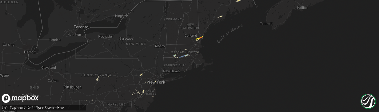
Hail Map in Massachusetts on July 31, 2019
The weather event in Massachusetts on July 31, 2019 includes Hail and Wind maps. 29 states and 540 cities were impacted and suffered possible damage. The total estimated number of properties impacted is 7,405.
Want more than just the map?
Turn this storm into a full workflow.
- Owner + property data so you know who to knock
- OnDemand branded weather history reports to win the "did we even have hail?" argument
- RoofTrace estimate so reps stop guessing numbers at the door
Bought this map? Upgrade within 7 days and we'll credit the $230. (10-15 min setup call)
Hail
Wind
7,405
Estimated number of impacted properties by a 1.00" hail or larger0
Estimated number of impacted properties by a 1.75" hail or larger0
Estimated number of impacted properties by a 2.50" hail or largerStorm reports in Massachusetts
Massachusetts
| Date | Description |
|---|---|
| 07/31/20194:04 PM CDT | Tree down on buckhorn terrace |
| 07/31/20193:37 PM CDT | Tree and wires down on washington street |
| 07/31/20193:28 PM CDT | Tree down on house on greendale ave |
| 07/31/20193:26 PM CDT | Multiple trees down across town |
| 07/31/20193:26 PM CDT | Trees down on ballard street |
| 07/31/20193:20 PM CDT | Tree down on lake street |
| 07/31/20193:18 PM CDT | Tree down on holyoke street |
| 07/31/20193:16 PM CDT | Trees down on ballard street |
| 07/31/20193:15 PM CDT | Tree down on washington street |
| 07/31/20193:01 PM CDT | Tree and wires down on powder house court |
| 07/31/20193:00 PM CDT | Tree down on concord ave and corp burns road |
| 07/31/20193:00 PM CDT | Tree down blocking baywater and annavoy street |
| 07/31/20193:00 PM CDT | Tree down on sagamore street |
| 07/31/20192:57 PM CDT | Multiple sail boats capsized at cottage park yacht club due to microburst winds 70 to 80 mph |
| 07/31/20192:57 PM CDT | Tree down on wires on florence ave |
| 07/31/20192:54 PM CDT | Multiple trees down across town |
| 07/31/20192:53 PM CDT | A local report indicates 73 MPH wind near LOGAN AP |
| 07/31/20192:52 PM CDT | Multiple sail boats capsized at cottage park yacht club due to microburst winds 70 to 80 mph |
| 07/31/20192:50 PM CDT | Many trees down on atlantic avenue |
| 07/31/20192:50 PM CDT | Multiple trees down across town |
| 07/31/20192:47 PM CDT | Multiple trees down in the annisquam area |
| 07/31/20192:44 PM CDT | Wires down between western ave and washington and franklin |
| 07/31/20192:30 PM CDT | Tree down on forest street |
| 07/31/20192:30 PM CDT | Multiple trees down across town |
| 07/31/20192:30 PM CDT | A local report indicates 68 MPH wind near LOGAN AP |
| 07/31/20192:30 PM CDT | Tree down on central turpike near oxford town line |
| 07/31/20192:28 PM CDT | Trees down on glenwood and campbell streets |
| 07/31/20192:27 PM CDT | Tree down on lake street |
| 07/31/20192:27 PM CDT | Tree down on utility ploe on oakcrest road |
| 07/31/20192:27 PM CDT | Tree down blocking hopkington road at the hopkinton/upton line |
| 07/31/20192:17 PM CDT | Tree down on wires on southbridge road |
| 07/31/20192:15 PM CDT | A local report indicates 1.00 inch wind near AUBURN |
| 07/31/20192:05 PM CDT | Tree down on car on slater street |
| 07/31/20191:55 PM CDT | Trees down on glenwood and campbell streets |
| 07/31/20191:50 PM CDT | Tree down on wires on southbridge road |
| 07/31/20191:42 PM CDT | Tree down on wires on muddy brook street |
| 07/31/20191:29 PM CDT | Tree down on car on beverly street |
| 07/31/20191:23 PM CDT | Tree down on wires on rte 5 and route 91 |
| 07/31/20191:00 PM CDT | Tree down on wires on north street extension |
| 07/31/201912:51 PM CDT | Tree down on wires on north street extension |
| 07/31/201912:50 PM CDT | Tractor trailer truck blown over by wind on route 90 mass pike by exit 4 also tree down on highland street which is route 5 at route 91. |
| 07/31/201912:50 PM CDT | Tree down on car on beverly street |
| 07/31/201912:50 PM CDT | Tree down on wires on rte 5 and route 91 |
| 07/31/201912:47 PM CDT | Amateur radio |
| 07/31/201912:30 PM CDT | Tree down blocking road on lockhouse road |
| 07/31/201912:26 PM CDT | Amateur radio confirmed by broadcast media |
| 07/30/201911:14 PM CDT | At 413 PM EDT, a severe thunderstorm was located over Quincy, moving northeast at 35 mph. HAZARD...60 mph wind gusts and penny size hail. SOURCE...Radar indicated. IMPACT...Expect damage to trees and power lines. Locations impacted include... Boston, Quincy, Brookline, Weymouth, Braintree, Randolph, Milton, Hingham, Scituate, Winthrop, Holbrook, Hull, Cohasset, Avon and Nahant. |
| 07/30/201910:56 PM CDT | At 356 PM EDT, a severe thunderstorm was located over Exeter, moving east at 25 mph. HAZARD...60 mph wind gusts and quarter size hail. SOURCE...Radar indicated. IMPACT...Hail damage to vehicles is expected. Expect wind damage to roofs, siding, and trees. Locations impacted include... Portsmouth, Hampton, Exeter, Kittery, Epping, Brentwood, Greenland, Stratham, Seabrook, Rye, York, Newington, Newmarket, Eliot, Kingston, East Kingston, Hampton Falls, Kensington, Newfields and North Hampton.This includes the following highways... Interstate 95 between mile markers 1 and 2. Interstate 95 in New Hampshire between mile markers 0 and 16.This also includes... Hampton Beach. |
| 07/30/201910:55 PM CDT | At 354 PM EDT, a severe thunderstorm was located over Marblehead, or near Beverly, moving northeast at 20 mph. This storm will affect areas along the immediate coastline. HAZARD...60 mph wind gusts and penny size hail. SOURCE...Radar indicated. IMPACT...Expect damage to trees and power lines. Locations impacted include... Salem, Beverly, Gloucester, Marblehead, Swampscott, Ipswich, Hamilton, Rockport, Manchester, Wenham and Essex. |
| 07/30/201910:41 PM CDT | At 340 PM EDT, a severe thunderstorm was located near Boston, moving northeast at 15 mph. HAZARD...60 mph wind gusts and quarter size hail. SOURCE...Radar indicated. IMPACT...Expect damage to trees and power lines and possible damage from hail. Locations impacted include... Boston, Quincy and Winthrop. |
| 07/30/201910:03 PM CDT | At 302 PM EDT, a severe thunderstorm was located over Oxford, or 11 miles south of Worcester, moving east at 20 mph. HAZARD...60 mph wind gusts and quarter size hail. SOURCE...Radar indicated. IMPACT...Expect damage to trees and power lines and possibly some hail damage to vehicles. Locations impacted include... Westborough, Grafton, Webster, Auburn, Northbridge, Oxford, Uxbridge, Millbury, Charlton, Dudley, Sutton, Douglas, Upton, Mendon and Millville. |
| 07/30/20199:13 PM CDT | At 212 PM EDT, a severe thunderstorm was located over Hampden, or 7 miles southeast of Springfield, moving east at 20 mph. HAZARD...60 mph wind gusts and quarter size hail. SOURCE...Radar indicated. IMPACT...Hail damage to vehicles is possible. Expect damage to trees and power lines. Locations impacted include... Springfield, Southbridge, East Longmeadow, Wilbraham, Palmer, Stafford, Somers, Sturbridge, Monson, Woodstock, Hampden, Warren, West Brookfield, Brimfield, Brookfield, Holland, Wales and Union. |
| 07/30/20199:05 PM CDT | At 205 PM EDT, a severe thunderstorm was located over Belchertown, or 7 miles southeast of Amherst, moving east at 25 mph. HAZARD...60 mph wind gusts and quarter size hail. SOURCE...Radar indicated. IMPACT...Hail damage to vehicles is possible. Expect damage to trees and power lines. Locations impacted include... Amherst, Belchertown, Ware, Granby, Barre, North Brookfield, West Brookfield, Hardwick, Pelham, Petersham, New Braintree and New Salem. |
| 07/30/20198:22 PM CDT | At 121 PM EDT, a severe thunderstorm was located over Westfield, moving east at 15 mph. HAZARD...60 mph wind gusts and quarter size hail. SOURCE...Radar indicated. IMPACT...Hail damage to vehicles is possible. Expect damage to trees and power lines. Locations impacted include... Springfield, Chicopee, Westfield, Holyoke, West Springfield, Ludlow, South Hadley, Wilbraham, Granby and Southampton. |
All States Impacted by Hail Map on July 31, 2019
Cities Impacted by Hail Map on July 31, 2019
- Mallie, KY
- Hindman, KY
- Pippa Passes, KY
- Alsen, ND
- Langdon, ND
- New Town, ND
- Anniston, AL
- Thayer, KS
- Mars Hill, ME
- Elkton, VA
- Greensboro, NC
- Eliot, ME
- Portsmouth, NH
- Kittery, ME
- Greenland, NH
- Newmarket, NH
- Newfields, NH
- Stratham, NH
- Jacksonville, AL
- Adams, ND
- Fairdale, ND
- Fleming, CO
- Lankin, ND
- Southbridge, MA
- La Crosse, KS
- Meriden, KS
- Todd, NC
- Williamsburg, KS
- Waverly, KS
- Melvern, KS
- Netawaka, KS
- Whiting, KS
- Horton, KS
- Powhattan, KS
- Okeechobee, FL
- Torrington, WY
- Pearce, AZ
- Elfrida, AZ
- Killdeer, ND
- Stanley, ND
- Princeton, KS
- Richmond, KS
- Leesburg, FL
- Clearmont, WY
- Ault, CO
- Briggsdale, CO
- Barboursville, VA
- Independence, KS
- Buffalo, KS
- Chanute, KS
- Altoona, KS
- Cherryvale, KS
- Benedict, KS
- Liberty, KS
- Neodesha, KS
- Feeding Hills, MA
- Southwick, MA
- Holyoke, MA
- Westfield, MA
- West Springfield, MA
- Wiggins, CO
- Roggen, CO
- Laramie, WY
- Lake Lure, NC
- Mill Spring, NC
- Hendersonville, NC
- Glenburn, ND
- Vicco, KY
- Polk City, FL
- Orange, VA
- Mineral, VA
- Unionville, VA
- Spotsylvania, VA
- Hot Springs, NC
- Del Rio, TN
- Lansford, ND
- Claflin, KS
- Hoisington, KS
- Russell, KS
- Bunker Hill, KS
- Lusk, WY
- Sutton, MA
- Roanoke, VA
- Vinton, VA
- Kaycee, WY
- Glenrock, WY
- Douglas, WY
- Buford, WY
- Nekoma, KS
- Alexander, KS
- Rush Center, KS
- Glenside, PA
- Philadelphia, PA
- Edinburg, ND
- Amidon, ND
- Exeter, NH
- Hannah, ND
- Wales, ND
- Gridley, KS
- Le Roy, KS
- Yates Center, KS
- Burlington, KS
- Elkin, NC
- Dobson, NC
- Great Bend, KS
- Dorrance, KS
- Dora, AL
- Sumiton, AL
- Overbrook, KS
- East Stroudsburg, PA
- Bushkill, PA
- Renick, WV
- Downingtown, PA
- Exton, PA
- Topeka, KS
- Berryton, KS
- Tecumseh, KS
- Carbondale, KS
- Wakarusa, KS
- Covington, VA
- Hot Springs, VA
- Charlotte, NC
- Suffolk, VA
- Loretto, VA
- Champlain, VA
- Colonial Beach, VA
- Locust Dale, VA
- Madison, VA
- Aroda, VA
- Radiant, VA
- Caret, VA
- Hustle, VA
- Kinsale, VA
- Warsaw, VA
- Hague, VA
- Montross, VA
- Bosler, WY
- Baldwin City, KS
- Olmitz, KS
- Youngstown, OH
- Coila, MS
- McCune, KS
- Cope, SC
- Norway, SC
- Naples, FL
- Dunn Center, ND
- Bazine, KS
- Vaiden, MS
- Ottawa, KS
- State Road, NC
- Wadesboro, NC
- Beachwood, NJ
- Toms River, NJ
- Bayville, NJ
- Hoyt, KS
- Mayetta, KS
- Neosho Falls, KS
- Pomona, KS
- Garnett, KS
- Welda, KS
- Humboldt, KS
- Iola, KS
- Piqua, KS
- Colony, KS
- Westphalia, KS
- Lawrence, KS
- Feasterville Trevose, PA
- Morrisville, PA
- Langhorne, PA
- Newtown, PA
- Southampton, PA
- Garrett, WY
- Manning, ND
- Dickinson, ND
- Milton, ND
- Grafton, WV
- Kincaid, KS
- Morven, NC
- Grantsville, WV
- Baxter, KY
- Medora, ND
- Minot Afb, ND
- Berthold, ND
- Middlebrook, VA
- Goshen, VA
- Raphine, VA
- Donnybrook, ND
- Nunn, CO
- Ashville, AL
- Crozet, VA
- Free Union, VA
- Fort Morgan, CO
- Sulligent, AL
- Astor, FL
- Lecompton, KS
- Erie, KS
- Galesburg, KS
- Saint Paul, KS
- Hartford, TN
- Danville, NH
- Kingston, NH
- Scottsboro, AL
- Philipsburg, PA
- Ness City, KS
- Jefferson City, MT
- Buffalo, WY
- Apopka, FL
- Mount Dora, FL
- Sorrento, FL
- Huntingtown, MD
- Sunderland, MD
- Owings, MD
- Chesapeake Beach, MD
- Prince Frederick, MD
- Lebo, KS
- Ringgold, GA
- Tamiment, PA
- Perry, KS
- Grantville, KS
- La Harpe, KS
- Ozawkie, KS
- Fort Lupton, CO
- Platteville, CO
- Lothian, MD
- Lexington, MS
- Orangeburg, SC
- Frostburg, MD
- Telford, TN
- Limestone, TN
- Richmond, TX
- Rosenberg, TX
- Groveland, FL
- Howey In The Hills, FL
- Hallwood, VA
- Marion Station, MD
- Crisfield, MD
- Sanford, VA
- Jefferson, ME
- Morrisdale, PA
- Lanse, PA
- Grassflat, PA
- Quinton, AL
- Mandaree, ND
- Utica, KS
- Oldwick, NJ
- Califon, NJ
- Lebanon, NJ
- Edmore, ND
- Lawton, ND
- Baileyville, ME
- Princeton, ME
- Casa Grande, AZ
- Welch, OK
- Fleetwood, NC
- West Jefferson, NC
- Roslindale, MA
- Dorchester Center, MA
- Dorchester, MA
- Mattapan, MA
- Rillton, PA
- Irwin, PA
- Piedmont, AL
- Sloan, NV
- Wellsville, KS
- Bluefield, WV
- Jersey City, NJ
- Locust Grove, VA
- Lexington, VA
- Fairfield, VA
- Buena Vista, VA
- Freeburn, KY
- East Granby, CT
- West Suffield, CT
- Moran, KS
- Elsmore, KS
- Fairview, NC
- Horton, AL
- Grottoes, VA
- Port Republic, VA
- Parsons, KS
- Canfield, OH
- Salem, OH
- Columbiana, OH
- Matewan, WV
- Harrisonburg, VA
- Haxtun, CO
- Lenapah, OK
- Palermo, ND
- Jonesville, VA
- Hoboken, NJ
- Tellico Plains, TN
- Auburn, KS
- Ruckersville, VA
- Stanardsville, VA
- Crystal River, FL
- Punta Gorda, FL
- Hiawatha, KS
- Morrill, KS
- Fairview, KS
- Maida, ND
- Osnabrock, ND
- Harpersville, AL
- Lancaster, VA
- Pelham, GA
- Chula, GA
- Savonburg, KS
- Moultrie, GA
- York, ME
- Kittery Point, ME
- Fremont, NH
- Epping, NH
- Conshohocken, PA
- Plymouth Meeting, PA
- Norristown, PA
- Bridgeport, PA
- Blue Bell, PA
- King Of Prussia, PA
- Vale, NC
- Levittown, PA
- Bensalem, PA
- Helton, KY
- Mozelle, KY
- Swansea, SC
- Plaza, ND
- Blountsville, AL
- Guntersville, AL
- Boaz, AL
- Majestic, KY
- Starkville, MS
- Mechanicsville, MD
- Port Republic, MD
- Amherst, VA
- Deland, FL
- Paisley, FL
- Altoona, FL
- Loganton, PA
- Holton, KS
- Gordonsville, VA
- Waldoboro, ME
- Union, ME
- Lawrenceville, GA
- McGaheysville, VA
- Chuckey, TN
- Colts Neck, NJ
- Altamont, KS
- Oswego, KS
- Cedarbluff, MS
- Princeton, WV
- Vinita, OK
- Sabetha, KS
- Wetmore, KS
- Eagle Rock, VA
- Ware, MA
- Lansing, NC
- Michigan, ND
- Springville, AL
- Barre, MA
- New Braintree, MA
- Gilbertville, MA
- Oakham, MA
- Dawson, NE
- Malvern, PA
- Warrensville, NC
- Gladstone, ND
- Chester Springs, PA
- Fort Myers, FL
- Brookville, KS
- Ellsworth, KS
- Union City, NJ
- Belchertown, MA
- Granby, MA
- Collinsville, AL
- Fort Payne, AL
- North Oxford, MA
- Dudley, MA
- Oxford, MA
- South Grafton, MA
- Millbury, MA
- Grafton, MA
- Charlton, MA
- Northbridge, MA
- Auburn, MA
- Hampden, ND
- Lance Creek, WY
- Benedict, MD
- Saint Leonard, MD
- Hughesville, MD
- North Beach, MD
- Aquasco, MD
- New Stanton, PA
- Ruffs Dale, PA
- Sidney, KY
- Schwenksville, PA
- Harleysville, PA
- Grassy Butte, ND
- Morganton, NC
- Connelly Springs, NC
- Lake Toxaway, NC
- Sapphire, NC
- Black Mountain, NC
- Eustis, FL
- Okahumpka, FL
- Center Hill, FL
- Banner, WY
- Swoope, VA
- Minot, ND
- Rainelle, WV
- Buchanan, VA
- Fincastle, VA
- Lost Springs, WY
- Sandy Ridge, PA
- Osceola Mills, PA
- Port Matilda, PA
- Tyrone, PA
- Ochlocknee, GA
- Crumpler, NC
- Bowman, ND
- Weehawken, NJ
- North Bergen, NJ
- Woolwine, VA
- Ransom, KS
- Stark, KS
- Orma, WV
- Raymond, NH
- Durham, NH
- Seibert, CO
- Maxbass, ND
- Zieglerville, PA
- Perkiomenville, PA
- Tunnel Hill, GA
- Beeler, KS
- Englewood, TN
- Wales, MA
- Holland, MA
- Aurora, ME
- Sterling, MA
- Rutland, MA
- Princeton, MA
- Dighton, KS
- Bland, VA
- Nobleboro, ME
- Washington, ME
- Lyndon, KS
- Scranton, KS
- Vassar, KS
- Osage City, KS
- Quenemo, KS
- Williamsburg, WV
- Edna, KS
- Bartlett, KS
- Churchville, VA
- Monroe, VA
- Chetopa, KS
- Flintstone, MD
- Clearville, PA
- Nekoma, ND
- Somerset, VA
- Rochelle, VA
- Van Tassell, WY
- Jefferson, NC
- Lottsburg, VA
- Sturgis, MS
- Paola, KS
- Rantoul, KS
- Homosassa, FL
- East Longmeadow, MA
- Enfield, CT
- Somers, CT
- Clover, SC
- Burlingame, KS
- Oskaloosa, KS
- Denison, KS
- Valley Falls, KS
- Silver Lake, KS
- Greeley, KS
- Suffield, CT
- Augusta, GA
- Orient, ME
- Gates, NC
- Hamptonville, NC
- Boonville, NC
- Whitewood, SD
- Wellington, AL
- Middletown, NJ
- Lincroft, NJ
- Grovetown, GA
- Bledsoe, KY
- Rapidan, VA
- Bristol, PA
- Upton, MA
- Albemarle, NC
- Inglis, FL
- Cameron, SC
- Chatham, NJ
- Steeles Tavern, VA
- Glade Spring, VA
- Watford City, ND
- Trenton, FL
- Newberry, FL
- New Springfield, OH
- Bedminster, NJ
- Far Hills, NJ
- North Wales, PA
- Ambler, PA
- Lansdale, PA
- Christmas, FL
- Shawnee, WY
- Blue Ridge, VA
- Estill, SC
- Manville, WY
- Millboro, VA
- Java, VA
- High Point, NC
- Rome, GA
- East Kingston, NH
- New England, ND
- Belfield, ND
- Ross, ND
- Kenmare, ND
- Tolley, ND
- Carpio, ND
- Hoople, ND
- Chicopee, MA
- Broadus, MT
- Otter, MT
- Wilson, KS
- Kingston, GA
- Bison, KS
- McCracken, KS
- Ellinwood, KS
- Washburn, ME
- Mapleton, ME
- Ashland, ME
- Caribou, ME
- Brimfield, MA
- Stafford Springs, CT
- Fiskdale, MA
- Sturbridge, MA
- Monson, MA
- Hickory, NC


