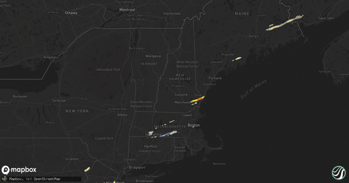
Hail Map in New Hampshire on July 31, 2019
Get this storm
July 31 map
$229
one time, instant access
Download today. No call, no setup
Keep the $229
Bought the map and want the full workflow? Apply the entire $229 to a subscription within 7 days. None of it is wasted.
Every map, not just this one
This buys you this map. Subscription and you get every map we run, in the markets you choose from a few cities to whole states to nationwide. Plus real-time alerts the moment a storm fires.
Contact data
Name, contact info, occupancy, even credit band for addresses in the footprint. You go from where it hit to who to call.
Become the source they trust
Unlimited branding weather history reports on demand. You already have the documented answer ready for the property owner, and you are the one who showed up with it.
Property data and RoofTrace estimates
Pull up any address you have got, its value and the exact code rules for that jurisdiction, straight from One Click Code. Then RoofTrace estimates the squares, pitch, and roof value, priced the way you price.
Storm reports in New Hampshire
New Hampshire
| Date | Description |
|---|---|
| 07/31/20193:10 PM CDT | Twitter photo |
| 07/31/20193:08 PM CDT | Picture from teiiter showing quarter size hail. |
| 07/31/20193:05 PM CDT | Trees down in exeter. Exeter police. |
| 07/31/20192:55 PM CDT | Numerous quarter to half dollar sized hail stones. Largest stones were golf ball size. |
| 07/31/20192:54 PM CDT | Epping coop reported half dollar size hail |
| 07/31/20192:32 PM CDT | Trees on wires on shirkin rd and beede hill road in freemont. |
| 07/31/20192:15 PM CDT | Epping coop reported half dollar size hail |
All States Impacted by Hail Map on July 31, 2019
Cities Impacted by Hail Map on July 31, 2019
- Mallie, KY
- Hindman, KY
- Pippa Passes, KY
- Alsen, ND
- Langdon, ND
- New Town, ND
- Anniston, AL
- Thayer, KS
- Mars Hill, ME
- Elkton, VA
- Greensboro, NC
- Eliot, ME
- Portsmouth, NH
- Kittery, ME
- Greenland, NH
- Newmarket, NH
- Newfields, NH
- Stratham, NH
- Jacksonville, AL
- Adams, ND
- Fairdale, ND
- Fleming, CO
- Lankin, ND
- Southbridge, MA
- La Crosse, KS
- Meriden, KS
- Todd, NC
- Williamsburg, KS
- Waverly, KS
- Melvern, KS
- Netawaka, KS
- Whiting, KS
- Horton, KS
- Powhattan, KS
- Okeechobee, FL
- Torrington, WY
- Pearce, AZ
- Elfrida, AZ
- Killdeer, ND
- Stanley, ND
- Princeton, KS
- Richmond, KS
- Leesburg, FL
- Clearmont, WY
- Ault, CO
- Briggsdale, CO
- Barboursville, VA
- Independence, KS
- Buffalo, KS
- Chanute, KS
- Altoona, KS
- Cherryvale, KS
- Benedict, KS
- Liberty, KS
- Neodesha, KS
- Feeding Hills, MA
- Southwick, MA
- Holyoke, MA
- Westfield, MA
- West Springfield, MA
- Wiggins, CO
- Roggen, CO
- Laramie, WY
- Lake Lure, NC
- Mill Spring, NC
- Hendersonville, NC
- Glenburn, ND
- Vicco, KY
- Polk City, FL
- Orange, VA
- Mineral, VA
- Unionville, VA
- Spotsylvania, VA
- Hot Springs, NC
- Del Rio, TN
- Lansford, ND
- Claflin, KS
- Hoisington, KS
- Russell, KS
- Bunker Hill, KS
- Lusk, WY
- Sutton, MA
- Roanoke, VA
- Vinton, VA
- Kaycee, WY
- Glenrock, WY
- Douglas, WY
- Buford, WY
- Nekoma, KS
- Alexander, KS
- Rush Center, KS
- Glenside, PA
- Philadelphia, PA
- Edinburg, ND
- Amidon, ND
- Exeter, NH
- Hannah, ND
- Wales, ND
- Gridley, KS
- Le Roy, KS
- Yates Center, KS
- Burlington, KS
- Elkin, NC
- Dobson, NC
- Great Bend, KS
- Dorrance, KS
- Dora, AL
- Sumiton, AL
- Overbrook, KS
- East Stroudsburg, PA
- Bushkill, PA
- Renick, WV
- Downingtown, PA
- Exton, PA
- Topeka, KS
- Berryton, KS
- Tecumseh, KS
- Carbondale, KS
- Wakarusa, KS
- Covington, VA
- Hot Springs, VA
- Charlotte, NC
- Suffolk, VA
- Loretto, VA
- Champlain, VA
- Colonial Beach, VA
- Locust Dale, VA
- Madison, VA
- Aroda, VA
- Radiant, VA
- Caret, VA
- Hustle, VA
- Kinsale, VA
- Warsaw, VA
- Hague, VA
- Montross, VA
- Bosler, WY
- Baldwin City, KS
- Olmitz, KS
- Youngstown, OH
- Coila, MS
- McCune, KS
- Cope, SC
- Norway, SC
- Naples, FL
- Dunn Center, ND
- Bazine, KS
- Vaiden, MS
- Ottawa, KS
- State Road, NC
- Wadesboro, NC
- Beachwood, NJ
- Toms River, NJ
- Bayville, NJ
- Hoyt, KS
- Mayetta, KS
- Neosho Falls, KS
- Pomona, KS
- Garnett, KS
- Welda, KS
- Humboldt, KS
- Iola, KS
- Piqua, KS
- Colony, KS
- Westphalia, KS
- Lawrence, KS
- Feasterville Trevose, PA
- Morrisville, PA
- Langhorne, PA
- Newtown, PA
- Southampton, PA
- Garrett, WY
- Manning, ND
- Dickinson, ND
- Milton, ND
- Grafton, WV
- Kincaid, KS
- Morven, NC
- Grantsville, WV
- Baxter, KY
- Medora, ND
- Minot Afb, ND
- Berthold, ND
- Middlebrook, VA
- Goshen, VA
- Raphine, VA
- Donnybrook, ND
- Nunn, CO
- Ashville, AL
- Crozet, VA
- Free Union, VA
- Fort Morgan, CO
- Sulligent, AL
- Astor, FL
- Lecompton, KS
- Erie, KS
- Galesburg, KS
- Saint Paul, KS
- Hartford, TN
- Danville, NH
- Kingston, NH
- Scottsboro, AL
- Philipsburg, PA
- Ness City, KS
- Jefferson City, MT
- Buffalo, WY
- Apopka, FL
- Mount Dora, FL
- Sorrento, FL
- Huntingtown, MD
- Sunderland, MD
- Owings, MD
- Chesapeake Beach, MD
- Prince Frederick, MD
- Lebo, KS
- Ringgold, GA
- Tamiment, PA
- Perry, KS
- Grantville, KS
- La Harpe, KS
- Ozawkie, KS
- Fort Lupton, CO
- Platteville, CO
- Lothian, MD
- Lexington, MS
- Orangeburg, SC
- Frostburg, MD
- Telford, TN
- Limestone, TN
- Richmond, TX
- Rosenberg, TX
- Groveland, FL
- Howey In The Hills, FL
- Hallwood, VA
- Marion Station, MD
- Crisfield, MD
- Sanford, VA
- Jefferson, ME
- Morrisdale, PA
- Lanse, PA
- Grassflat, PA
- Quinton, AL
- Mandaree, ND
- Utica, KS
- Oldwick, NJ
- Califon, NJ
- Lebanon, NJ
- Edmore, ND
- Lawton, ND
- Baileyville, ME
- Princeton, ME
- Casa Grande, AZ
- Welch, OK
- Fleetwood, NC
- West Jefferson, NC
- Roslindale, MA
- Dorchester Center, MA
- Dorchester, MA
- Mattapan, MA
- Rillton, PA
- Irwin, PA
- Piedmont, AL
- Sloan, NV
- Wellsville, KS
- Bluefield, WV
- Jersey City, NJ
- Locust Grove, VA
- Lexington, VA
- Fairfield, VA
- Buena Vista, VA
- Freeburn, KY
- East Granby, CT
- West Suffield, CT
- Moran, KS
- Elsmore, KS
- Fairview, NC
- Horton, AL
- Grottoes, VA
- Port Republic, VA
- Parsons, KS
- Canfield, OH
- Salem, OH
- Columbiana, OH
- Matewan, WV
- Harrisonburg, VA
- Haxtun, CO
- Lenapah, OK
- Palermo, ND
- Jonesville, VA
- Hoboken, NJ
- Tellico Plains, TN
- Auburn, KS
- Ruckersville, VA
- Stanardsville, VA
- Crystal River, FL
- Punta Gorda, FL
- Hiawatha, KS
- Morrill, KS
- Fairview, KS
- Maida, ND
- Osnabrock, ND
- Harpersville, AL
- Lancaster, VA
- Pelham, GA
- Chula, GA
- Savonburg, KS
- Moultrie, GA
- York, ME
- Kittery Point, ME
- Fremont, NH
- Epping, NH
- Conshohocken, PA
- Plymouth Meeting, PA
- Norristown, PA
- Bridgeport, PA
- Blue Bell, PA
- King Of Prussia, PA
- Vale, NC
- Levittown, PA
- Bensalem, PA
- Helton, KY
- Mozelle, KY
- Swansea, SC
- Plaza, ND
- Blountsville, AL
- Guntersville, AL
- Boaz, AL
- Majestic, KY
- Starkville, MS
- Mechanicsville, MD
- Port Republic, MD
- Amherst, VA
- Deland, FL
- Paisley, FL
- Altoona, FL
- Loganton, PA
- Holton, KS
- Gordonsville, VA
- Waldoboro, ME
- Union, ME
- Lawrenceville, GA
- McGaheysville, VA
- Chuckey, TN
- Colts Neck, NJ
- Altamont, KS
- Oswego, KS
- Cedarbluff, MS
- Princeton, WV
- Vinita, OK
- Sabetha, KS
- Wetmore, KS
- Eagle Rock, VA
- Ware, MA
- Lansing, NC
- Michigan, ND
- Springville, AL
- Barre, MA
- New Braintree, MA
- Gilbertville, MA
- Oakham, MA
- Dawson, NE
- Malvern, PA
- Warrensville, NC
- Gladstone, ND
- Chester Springs, PA
- Fort Myers, FL
- Brookville, KS
- Ellsworth, KS
- Union City, NJ
- Belchertown, MA
- Granby, MA
- Collinsville, AL
- Fort Payne, AL
- North Oxford, MA
- Dudley, MA
- Oxford, MA
- South Grafton, MA
- Millbury, MA
- Grafton, MA
- Charlton, MA
- Northbridge, MA
- Auburn, MA
- Hampden, ND
- Lance Creek, WY
- Benedict, MD
- Saint Leonard, MD
- Hughesville, MD
- North Beach, MD
- Aquasco, MD
- New Stanton, PA
- Ruffs Dale, PA
- Sidney, KY
- Schwenksville, PA
- Harleysville, PA
- Grassy Butte, ND
- Morganton, NC
- Connelly Springs, NC
- Lake Toxaway, NC
- Sapphire, NC
- Black Mountain, NC
- Eustis, FL
- Okahumpka, FL
- Center Hill, FL
- Banner, WY
- Swoope, VA
- Minot, ND
- Rainelle, WV
- Buchanan, VA
- Fincastle, VA
- Lost Springs, WY
- Sandy Ridge, PA
- Osceola Mills, PA
- Port Matilda, PA
- Tyrone, PA
- Ochlocknee, GA
- Crumpler, NC
- Bowman, ND
- Weehawken, NJ
- North Bergen, NJ
- Woolwine, VA
- Ransom, KS
- Stark, KS
- Orma, WV
- Raymond, NH
- Durham, NH
- Seibert, CO
- Maxbass, ND
- Zieglerville, PA
- Perkiomenville, PA
- Tunnel Hill, GA
- Beeler, KS
- Englewood, TN
- Wales, MA
- Holland, MA
- Aurora, ME
- Sterling, MA
- Rutland, MA
- Princeton, MA
- Dighton, KS
- Bland, VA
- Nobleboro, ME
- Washington, ME
- Lyndon, KS
- Scranton, KS
- Vassar, KS
- Osage City, KS
- Quenemo, KS
- Williamsburg, WV
- Edna, KS
- Bartlett, KS
- Churchville, VA
- Monroe, VA
- Chetopa, KS
- Flintstone, MD
- Clearville, PA
- Nekoma, ND
- Somerset, VA
- Rochelle, VA
- Van Tassell, WY
- Jefferson, NC
- Lottsburg, VA
- Sturgis, MS
- Paola, KS
- Rantoul, KS
- Homosassa, FL
- East Longmeadow, MA
- Enfield, CT
- Somers, CT
- Clover, SC
- Burlingame, KS
- Oskaloosa, KS
- Denison, KS
- Valley Falls, KS
- Silver Lake, KS
- Greeley, KS
- Suffield, CT
- Augusta, GA
- Orient, ME
- Gates, NC
- Hamptonville, NC
- Boonville, NC
- Whitewood, SD
- Wellington, AL
- Middletown, NJ
- Lincroft, NJ
- Grovetown, GA
- Bledsoe, KY
- Rapidan, VA
- Bristol, PA
- Upton, MA
- Albemarle, NC
- Inglis, FL
- Cameron, SC
- Chatham, NJ
- Steeles Tavern, VA
- Glade Spring, VA
- Watford City, ND
- Trenton, FL
- Newberry, FL
- New Springfield, OH
- Bedminster, NJ
- Far Hills, NJ
- North Wales, PA
- Ambler, PA
- Lansdale, PA
- Christmas, FL
- Shawnee, WY
- Blue Ridge, VA
- Estill, SC
- Manville, WY
- Millboro, VA
- Java, VA
- High Point, NC
- Rome, GA
- East Kingston, NH
- New England, ND
- Belfield, ND
- Ross, ND
- Kenmare, ND
- Tolley, ND
- Carpio, ND
- Hoople, ND
- Chicopee, MA
- Broadus, MT
- Otter, MT
- Wilson, KS
- Kingston, GA
- Bison, KS
- McCracken, KS
- Ellinwood, KS
- Washburn, ME
- Mapleton, ME
- Ashland, ME
- Caribou, ME
- Brimfield, MA
- Stafford Springs, CT
- Fiskdale, MA
- Sturbridge, MA
- Monson, MA
- Hickory, NC


