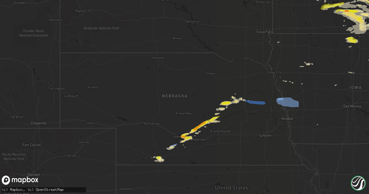
Hail Map in Nebraska on July 23, 2022
Get this storm
July 23 map
$229
one time, instant access
Download today. No call, no setup
Keep the $229
Bought the map and want the full workflow? Apply the entire $229 to a subscription within 7 days. None of it is wasted.
Every map, not just this one
This buys you this map. Subscription and you get every map we run, in the markets you choose from a few cities to whole states to nationwide. Plus real-time alerts the moment a storm fires.
Contact data
Name, contact info, occupancy, even credit band for addresses in the footprint. You go from where it hit to who to call.
Become the source they trust
Unlimited branding weather history reports on demand. You already have the documented answer ready for the property owner, and you are the one who showed up with it.
Property data and RoofTrace estimates
Pull up any address you have got, its value and the exact code rules for that jurisdiction, straight from One Click Code. Then RoofTrace estimates the squares, pitch, and roof value, priced the way you price.
Storm reports in Nebraska
Nebraska
| Date | Description |
|---|---|
| 07/23/20226:47 PM CDT | A local report indicates 1.25 inch wind near ALBION |
| 07/23/20226:35 PM CDT | Trained spotter reported ping pong ball sized hail. |
| 07/23/20226:21 PM CDT | Time estimated from radar. Large tree blown over. |
| 07/23/20226:07 PM CDT | 8-10 inch tree branches down around town. |
| 07/23/20225:59 PM CDT | Knecushi1. |
| 07/23/20225:52 PM CDT | Updates previous tstm wnd dmg report from saint paul. Received a twitter report of tree damage across town and was confirmed by howard county dispatch. Time estimated f |
| 07/23/20225:52 PM CDT | Received a twitter report of tree damage across town and was confirmed by howard county dispatch. Time estimated from radar. |
| 07/23/20225:52 PM CDT | Received a twitter report of tree damage across town and was confirmed by howard county dispatch. Time e |
| 07/23/20225:46 PM CDT | Several 13 inch diameter tree limbs snapped off as well as trees blown down. Estimated 60 to 70 mph wind gusts. |
| 07/23/20225:44 PM CDT | Hail up to quarter size. Also estimated winds to around 50 mph with small branches down. Time estimated from radar. |
| 07/23/20225:37 PM CDT | Delayed facebook report of tree damage and pivots overturned... With corn almost laying flat. Time estimated from radar. |
| 07/23/20225:07 PM CDT | Quarter to half dollar size hail. Time estimated from radar. |
| 07/23/20224:54 PM CDT | Davis weatherlink station. |
| 07/23/20224:46 PM CDT | Spotter network report of several 4 inch diameter branches down on west side of overton. Time of event estimated from radar. |
| 07/23/20224:45 PM CDT | Facebook photo of hail that appears to be at least half dollar size. Time estimated from radar. |
| 07/23/20224:40 PM CDT | Spotter relayed second hand report of hail at sartoria. Time estimated from radar. |
| 07/23/20224:37 PM CDT | Estimated 50 to 60 mph winds. |
| 07/23/20224:13 PM CDT | Facebook video depicts hail to at least quarter size at overton golf course. |
| 07/23/20224:07 PM CDT | Public report and video relayed to dispatcher. |
| 07/23/20224:02 PM CDT | A local report indicates 70 MPH wind near 3 ESE INDIANOLA |
| 07/23/20223:36 PM CDT | Thunderstorm wind gust of 60 to 70 mph estimated at this location. |
| 07/23/20223:29 PM CDT | A local report indicates 59 MPH wind near 1 ENE MCCOOK |
| 07/23/20223:07 PM CDT | A local report indicates 61 MPH wind near 1 ENE MCCOOK |
| 07/23/20227:56 AM CDT | At 1255 AM CDT, a severe thunderstorm was located near Gibbon, or 11 miles northeast of Kearney, moving southeast at 20 mph. HAZARD...60 mph wind gusts and half dollar size hail. SOURCE...Radar indicated. IMPACT...Hail damage to vehicles is expected. Expect wind damage to roofs, siding, and trees. This severe thunderstorm will be near... Gibbon around 110 AM CDT.Other locations in the path of this severe thunderstorm includeShelton.This includes Interstate 80 between mile markers 283 and 292. |
| 07/23/20227:30 AM CDT | At 1230 AM CDT, a severe thunderstorm was located near Poole, or 15 miles north of Kearney, moving east at 10 mph. HAZARD...Quarter size hail. SOURCE...Radar indicated. IMPACT...Damage to vehicles is expected. This severe thunderstorm will be near... Poole around 1250 AM CDT.Other locations in the path of this severe thunderstorm includeRavenna. |
| 07/23/20222:29 AM CDT | At 729 PM CDT, a severe thunderstorm was located 6 miles south of Dodge, or 18 miles southwest of West Point, moving east at 55 mph. HAZARD...60 mph wind gusts and quarter size hail. SOURCE...Radar indicated. IMPACT...Hail damage to vehicles is expected. Expect wind damage to roofs, siding, and trees. This severe thunderstorm will be near... Snyder around 735 PM CDT. Scribner around 745 PM CDT.Other locations in the path of this severe thunderstorm includeHooper, Nickerson and Arlington. |
| 07/23/20222:26 AM CDT | At 726 PM CDT, a severe thunderstorm was located 5 miles southeast of Humphrey, or 13 miles north of Columbus, moving east at 40 mph. HAZARD...60 mph wind gusts and quarter size hail. SOURCE...Radar indicated. IMPACT...Hail damage to vehicles is expected. Expect wind damage to roofs, siding, and trees. This severe thunderstorm will be near... Creston and Lakeview around 730 PM CDT. Leigh around 740 PM CDT. |
| 07/23/20222:05 AM CDT | At 704 PM CDT, a severe thunderstorm was located near Creston, or 20 miles south of Norfolk, moving east at 35 mph. HAZARD...60 mph wind gusts and quarter size hail. SOURCE...Radar indicated. IMPACT...Hail damage to vehicles is expected. Expect wind damage to roofs, siding, and trees. This severe thunderstorm will be near... Leigh around 715 PM CDT.Other locations in the path of this severe thunderstorm includeClarkson and Howells. |
| 07/23/20221:45 AM CDT | At 644 PM CDT, a severe thunderstorm was located 6 miles north of St. Edward, or 8 miles east of Albion, moving east at 40 mph. HAZARD...Ping pong ball size hail and 60 mph wind gusts. SOURCE...Trained weather spotters. This storm has a history of producing ping pong ball sized hail. IMPACT...People and animals outdoors will be injured. Expect hail damage to roofs, siding, windows, and vehicles. Expect wind damage to roofs, siding, and trees. This severe thunderstorm will be near... Lindsay around 655 PM CDT.Other locations in the path of this severe thunderstorm includeHumphrey. |
| 07/23/20221:26 AM CDT | At 626 PM CDT, a severe thunderstorm was located 5 miles northeast of Primrose, or 8 miles west of Albion, moving east at 25 mph. HAZARD...Ping pong ball size hail and 60 mph wind gusts. SOURCE...Radar indicated. IMPACT...People and animals outdoors will be injured. Expect hail damage to roofs, siding, windows, and vehicles. Expect wind damage to roofs, siding, and trees. This severe thunderstorm will be near... Albion around 645 PM CDT. |
| 07/23/20221:21 AM CDT | At 621 PM CDT, a severe thunderstorm was located 7 miles north of Newman Grove, or 17 miles northeast of Albion, moving east at 25 mph. HAZARD...60 mph wind gusts and quarter size hail. SOURCE...Radar indicated. IMPACT...Hail damage to vehicles is expected. Expect wind damage to roofs, siding, and trees. Locations impacted include... Madison. |
| 07/23/20221:14 AM CDT | At 614 PM CDT, a severe thunderstorm was located 5 miles southwest of Cedar Rapids, or 17 miles southwest of Albion, moving east at 35 mph. HAZARD...60 mph wind gusts and quarter size hail. SOURCE...Radar indicated. IMPACT...Hail damage to vehicles is expected. Expect wind damage to roofs, siding, and trees. This severe thunderstorm will be near... Cedar Rapids around 620 PM CDT.Other locations in the path of this severe thunderstorm include St.Edward. |
| 07/23/20221:06 AM CDT | At 606 PM CDT, a severe thunderstorm was located over Wolbach, or 30 miles southeast of Ord, moving east at 40 mph. HAZARD...60 mph wind gusts and quarter size hail. SOURCE...Radar indicated. IMPACT...Hail damage to vehicles is expected. Expect wind damage to roofs, siding, and trees. Locations impacted include... Fullerton and Belgrade. |
| 07/23/202212:37 AM CDT | At 537 PM CDT, a severe thunderstorm was located near Ashton, or 26 miles northwest of Grand Island, moving east at 30 mph. HAZARD...60 mph wind gusts and quarter size hail. SOURCE...Radar indicated. IMPACT...Hail damage to vehicles is expected. Expect wind damage to roofs, siding, and trees. This severe thunderstorm will be near... Farwell around 550 PM CDT. Dannebrog around 555 PM CDT.Other locations in the path of this severe thunderstorm include Elba,St. Paul and Cushing. |
| 07/23/202212:18 AM CDT | At 518 PM CDT, a severe thunderstorm was located near Rockville, or 31 miles northwest of Grand Island, moving northeast at 30 mph. HAZARD...60 mph wind gusts and quarter size hail. SOURCE...Radar indicated. IMPACT...Hail damage to vehicles is expected. Expect wind damage to roofs, siding, and trees. This severe thunderstorm will be near... Ashton around 535 PM CDT.Other locations in the path of this severe thunderstorm includeFarwell. |
| 07/23/202212:01 AM CDT | At 501 PM CDT, a severe thunderstorm was located over Hazard, or 24 miles north of Kearney, moving northeast at 25 mph. HAZARD...60 mph wind gusts and half dollar size hail. SOURCE...Radar indicated. IMPACT...Hail damage to vehicles is expected. Expect wind damage to roofs, siding, and trees. This severe thunderstorm will be near... Hazard around 505 PM CDT. Ravenna around 520 PM CDT.Other locations in the path of this severe thunderstorm includeRockville. |
| 07/22/202211:50 PM CDT | At 450 PM CDT, a severe thunderstorm was located over Overton, or 12 miles east of Lexington, moving northeast at 40 mph. HAZARD...60 mph wind gusts and quarter size hail. SOURCE...Radar indicated. IMPACT...Hail damage to vehicles is expected. Expect wind damage to roofs, siding, and trees. This severe thunderstorm will be near... Elm Creek around 500 PM CDT. Odessa around 505 PM CDT. Amherst around 510 PM CDT.Other locations in the path of this severe thunderstorm includeRiverdale.This includes Interstate 80 between mile markers 249 and 264. |
| 07/22/202211:33 PM CDT | At 433 PM CDT, a severe thunderstorm was located near Miller, or 20 miles northwest of Kearney, moving east at 20 mph. HAZARD...60 mph wind gusts and half dollar size hail. SOURCE...Radar indicated. IMPACT...Hail damage to vehicles is expected. Expect wind damage to roofs, siding, and trees. Locations impacted include... Pleasanton. |
| 07/22/202211:26 PM CDT | At 425 PM CDT, a severe thunderstorm was located near Overton, or 14 miles east of Lexington, moving east at 30 mph. HAZARD...60 mph wind gusts and quarter size hail. SOURCE...Public reported quarter size hail on Facebook near Overton. IMPACT...Hail damage to vehicles is expected. Expect wind damage to roofs, siding, and trees. This severe thunderstorm will be near... Elm Creek around 435 PM CDT.Other locations in the path of this severe thunderstorm includeOdessa and Riverdale.This includes Interstate 80 between mile markers 251 and 269. |
| 07/22/202211:09 PM CDT | At 409 PM CDT, a severe thunderstorm was located near Lexington, moving northeast at 15 mph. HAZARD...Ping pong ball size hail and 60 mph wind gusts. SOURCE...Trained weather spotters reported ping pong ball size hail near Lexington. IMPACT...People and animals outdoors will be injured. Expect hail damage to roofs, siding, windows, and vehicles. Expect wind damage to roofs, siding, and trees. This severe thunderstorm will be near... Overton around 425 PM CDT.Other locations in the path of this severe thunderstorm includeSumner and Miller. |
| 07/22/202210:39 PM CDT | At 339 PM CDT, a severe thunderstorm was located 10 miles southwest of Elwood, or 24 miles southwest of Lexington, moving east at 25 mph. HAZARD...70 mph wind gusts and quarter size hail. SOURCE...Trained weather spotters reported nickel size hail and 70 mph wind. IMPACT...Hail damage to vehicles is expected. Expect considerable tree damage. Wind damage is also likely to mobile homes, roofs, and outbuildings. Locations impacted include... Elwood and Smithfield. |
| 07/22/202210:37 PM CDT | At 336 PM CDT, a severe thunderstorm was located 10 miles south of Eustis, or 23 miles southwest of Lexington, moving northeast at 25 mph. HAZARD...70 mph wind gusts. SOURCE...Public. IMPACT...Expect considerable tree damage. Damage is likely to mobile homes, roofs, and outbuildings. This severe thunderstorm will remain over mainly rural areas of east central Frontier County. |
| 07/22/20228:57 PM CDT | At 157 AM CDT, a severe thunderstorm was located near Juniata, or 10 miles west of Hastings, moving southeast at 20 mph. HAZARD...Quarter size hail. SOURCE...Radar indicated. IMPACT...Damage to vehicles is expected. This severe thunderstorm will be near... Juniata around 205 AM CDT. Roseland around 210 AM CDT.Other locations in the path of this severe thunderstorm include Ayr. |
| 07/22/20228:27 PM CDT | At 126 AM CDT, a severe thunderstorm was located near Kenesaw, or 17 miles east of Kearney, moving east at 15 mph. HAZARD...Half dollar size hail. SOURCE...Radar indicated. IMPACT...Damage to vehicles is expected. Locations impacted include... Kenesaw, Prosser and Juniata.This includes Interstate 80 between mile markers 288 and 297. |
| 07/22/20228:25 PM CDT | Updates previous tstm wnd gst report from tekamah asos. Peak sustained measured wind was 51 mph and peak measured gust was 75 mph. |
| 07/22/20228:15 PM CDT | Tekamah asos measured a peak wind gust of 74 mph. |
| 07/22/20228:15 PM CDT | Law enforcement relayed reports of several medium to large size trees down in the city. Additionally... A car was blown off the road west of town. |
| 07/22/20228:10 PM CDT | A local report indicates 87 MPH wind near CRAIG |
| 07/22/20227:50 PM CDT | Corrects time of previous tstm wnd dmg report from 3 sse central city. Time estimated from radar. Large tree blown over. |
| 07/22/20227:45 PM CDT | Delayed report. Numerous tree branches down. |
| 07/22/20227:26 PM CDT | Updates previous tstm wnd gst report from 3 ssw norfolk. |
| 07/22/20227:15 PM CDT | A local report indicates 60 MPH wind near 2 N CRESTON |
| 07/22/20227:11 PM CDT | A local report indicates 59 MPH wind near 3 SSW NORFOLK |
All States Impacted by Hail Map on July 23, 2022
Cities Impacted by Hail Map on July 23, 2022
- Byron, MN
- Hayfield, MN
- Stewartville, MN
- Lonsdale, MN
- Montgomery, MN
- Elroy, WI
- Alger, MI
- Gladwin, MI
- Ortley, SD
- Wallace, SD
- Florence, SD
- Stevens Point, WI
- Rudolph, WI
- Grand Haven, MI
- Spring Lake, MI
- Peever, SD
- Webster, SD
- Waubay, SD
- Spring Valley, MN
- Rochester, MN
- Eyota, MN
- Glenbeulah, WI
- Bangor, WI
- Saint Paul, NE
- Wolbach, NE
- Hillsboro, WI
- Wonewoc, WI
- Smithland, IA
- Hornick, IA
- Plainfield, IL
- South Shore, SD
- Milbank, SD
- Marvin, SD
- Ortonville, MN
- Bellingham, MN
- Stockholm, SD
- Marietta, MN
- Goodwin, SD
- Revillo, SD
- Odessa, MN
- Big Stone City, SD
- Labolt, SD
- Watertown, SD
- Summit, SD
- Strandburg, SD
- Twin Brooks, SD
- Hillpoint, WI
- La Valle, WI
- Cazenovia, WI
- Pittsville, WI
- Poynette, WI
- Farwell, NE
- Miller, NE
- Rockville, NE
- Dannebrog, NE
- Boelus, NE
- Ravenna, NE
- Bertrand, NE
- Lexington, NE
- Elm Creek, NE
- Sumner, NE
- Hazard, NE
- Loup City, NE
- Amherst, NE
- Palmer, NE
- Smithfield, NE
- Overton, NE
- Elba, NE
- Ashton, NE
- Pleasanton, NE
- Bowling Green, OH
- Riverdale, NE
- Greensburg, PA
- Jeannette, PA
- Morgan, MN
- Sleepy Eye, MN
- Bristow, IA
- Aredale, IA
- Dumont, IA
- Watertown, WI
- Lake Mills, WI
- Williams, IA
- Northwood, IA
- Bowerston, OH
- Winamac, IN
- Star City, IN
- Kewanna, IN
- Middlebourne, WV
- New Creek, WV
- Grand Meadow, MN
- Racine, MN
- Doon, IA
- Wisconsin Rapids, WI
- West Olive, MI
- Hanley Falls, MN
- Belle Plaine, MN
- Gibbon, MN
- Gaylord, MN
- Madison, MN
- Granite Falls, MN
- Belview, MN
- Morton, MN
- Henderson, MN
- Watson, MN
- Clarkfield, MN
- Echo, MN
- Bird Island, MN
- Montevideo, MN
- Franklin, MN
- Sacred Heart, MN
- Wood Lake, MN
- Maynard, MN
- Arlington, MN
- Winthrop, MN
- Redwood Falls, MN
- Le Sueur, MN
- Dawson, MN
- Danube, MN
- Clara City, MN
- New Prague, MN
- Milan, MN
- Lafayette, MN
- New Ulm, MN
- Olivia, MN
- Renville, MN
- Le Center, MN
- Fairfax, MN
- Saint Peter, MN
- Berlin, WI
- Ripon, WI
- East Tawas, MI
- Friendship, WI
- Mauston, WI
- Wisconsin Dells, WI
- Lyndon Station, WI
- Coloma, WI
- Adams, WI
- Westfield, WI
- Grand Marsh, WI
- Oxford, WI
- Custar, OH
- Weston, OH
- Creola, OH
- Canaan, VT
- Norton, VT
- Averill, VT
- Van Wert, OH
- Middle Point, OH
- Newton, WV
- Left Hand, WV
- Chatfield, MN
- Easton, MN
- Minnesota Lake, MN
- Channahon, IL
- Belle Vernon, PA
- West Newton, PA
- Smithton, PA
- Brillion, WI
- Leechburg, PA
- New Kensington, PA
- Fort Atkinson, WI
- Jefferson, WI
- Newell, IA
- Albert City, IA
- Storm Lake, IA
- Hector, MN
- Beaver Dam, WI
- Stratford, SD
- Andover, SD
- Conde, SD
- Ferney, SD
- Bristol, SD
- Groton, SD
- Mikado, MI
- Greenbush, MI
- New Lisbon, WI
- Whitelaw, WI
- Valders, WI
- Newton, WI
- New Holstein, WI
- Chilton, WI
- Manitowoc, WI
- Saint Nazianz, WI
- Reedsville, WI
- Kiel, WI
- Pittsburg, NH
- Malone, WI
- Saint Cloud, WI
- Lanesboro, MN
- Preston, MN
- Dover, MN
- La Crosse, WI
- Coon Valley, WI
- West Salem, WI
- Stoddard, WI
- Chaseburg, WI
- Winona, MN
- Lewiston, MN
- La Crescent, MN
- Houston, MN
- Caledonia, MN
- Hokah, MN
- Derby Line, VT
- Deerfield, WI
- Marshall, WI
- Salem, WI
- Saukville, WI
- Port Washington, WI
- Random Lake, WI
- Oostburg, WI
- Belgium, WI
- Fredonia, WI
- Kewaskum, WI
- West Bend, WI
- Cedar Grove, WI
- Princeton, WI
- Neshkoro, WI
- Johnson Creek, WI
- Hartford, WI
- Black River Falls, WI
- Schleswig, IA
- Lake Mills, IA
- Fertile, IA
- Joice, IA
- Thompson, IA
- Hanlontown, IA
- Leland, IA
- Forest City, IA
- Everett, PA
- Bedford, PA
- Boyd, MN
- Webster City, IA
- Blairsburg, IA
- Coraopolis, PA
- Sewickley, PA
- Pittsburgh, PA
- Adell, WI
- Campbellsport, WI
- Sheboygan, WI
- Sheboygan Falls, WI
- Chatsworth, IL
- Piper City, IL
- Roberts, IL
- Westby, WI
- Genoa, WI
- Viroqua, WI
- Marion, NC
- Milton, WI
- Avalon, WI
- Mazomanie, WI
- Cross Plains, WI
- Middleton, WI
- Waunakee, WI
- Black Earth, WI
- Lake Geneva, WI
- Stoughton, WI
- Delavan, WI
- Edgerton, WI
- Whitewater, WI
- Janesville, WI
- Elkhorn, WI
- Oregon, WI
- Madison, WI
- Deforest, WI
- Sauk City, WI
- Dane, WI
- Lodi, WI
- Mcfarland, WI
- Cambridge, WI
- Cottage Grove, WI
- Broadway, NC
- Lillington, NC
- Wheaton, IL
- Lindsay, NE
- Saint Edward, NE
- Newman Grove, NE
- Primrose, NE
- Madison, NE
- Albion, NE
- Spalding, NE
- Humphrey, NE
- Cedar Rapids, NE
- Marquette, WI
- Dalton, WI
- Montello, WI
- Kingston, WI
- Markesan, WI
- Randolph, WI
- Buckhorn, KY
- Oneida, KY
- Greenup, KY
- Burgettstown, PA
- Georgetown, PA
- Moorefield, WV
- Mount Gilead, OH
- Cardington, OH
- Riverton, WV
- Upper Tract, WV
- Seneca Rocks, WV
- Flatwoods, WV
- Ohio City, OH
- Old Fields, WV
- Baker, WV
- Fisher, WV
- Rio, WV
- Webbville, KY
- Grayson, KY
- Sandy Hook, KY
- Pine Island, MN
- Olive Hill, KY
- Vanceburg, KY
- Emerson, KY
- Nebo, NC
- New Haven, IN
- Fort Wayne, IN
- Monroeville, IN
- Delphos, OH
- Glenshaw, PA
- Pontiac, IL
- Lamar, CO
- Chenoa, IL
- McCook, NE
- Letart, WV
- Hartford, WV
- Racine, OH
- Pomeroy, OH
- Syracuse, OH
- New Haven, WV
- Mason, WV
- Mount Pleasant, SC
- Cooksville, IL
- Colfax, IL
- Arrowsmith, IL
- Anchor, IL
- Foosland, IL
- Forrest, IL
- Gibson City, IL
- Bellflower, IL
- Cropsey, IL
- Saybrook, IL
- Fairbury, IL
- Lexington, IL
- Sibley, IL
- Fisher, IL
- Strawn, IL
- Petersburg, WV
- Ashland, KY
- Garrison, KY
- Rush, KY
- Argillite, KY
- Buckley, IL
- Bulger, PA
- Vanlue, OH
- Carey, OH
- Findlay, OH
- Alvada, OH
- Rayland, OH
- Yorkville, OH
- Tiltonsville, OH
- Decatur, IN
- Newport, OH
- Leicester, NC
- Alexander, NC
- Charleston, TN
- Cameron, NC
- Sanford, NC
- Vass, NC
- Eagle Rock, VA
- Helenwood, TN
- Oneida, TN
- Claremont, MN
- Dodge Center, MN
- Eustis, NE
- Fuquay Varina, NC
- Louisa, KY
- Bowling Green, KY
- Utica, MN
- Peterson, MN
- Wanamingo, MN
- West Concord, MN
- Seminole, FL
- Saint Petersburg, FL
- Clearwater, FL
- Largo, FL
- Pinellas Park, FL
- Kasota, MN
- Morehead, KY
- Salt Lick, KY
- Tampa, FL
- Manchester, KY
- Irwin, PA
- Adamsburg, PA
- Odessa, FL
- New Port Richey, FL
- Land O'Lakes, FL
- Sheldon, IL
- Crescent City, IL
- Milford, IL
- Fowler, IN
- Onarga, IL
- Watseka, IL
- Earl Park, IN
- Stockland, IL
- Cissna Park, IL
- Hubertus, WI
- Richfield, WI
- Colebrook, NH
- Owatonna, MN
- Blooming Prairie, MN
- Fenwick, MI
- Sheridan, MI
- Walterboro, SC
- Genoa, WV
- Wayne, WV
- Prichard, WV
- Fort Gay, WV
- Jacksonburg, WV
- Smithfield, WV
- Oldtown, MD
- Green Spring, WV
- Springfield, WV
- Fort Ashby, WV
- Levels, WV
- Burlington, WV
- Keyser, WV
- Romney, WV
- Olympia, KY
- Kingstree, SC
- Nesmith, SC
- Ronda, NC
- Roaring River, NC
- Hamptonville, NC
- Jonesville, NC
- Hayward, MN
- Waldorf, MN
- Brownsdale, MN
- Pemberton, MN
- Good Thunder, MN
- Eagle Lake, MN
- Hollandale, MN
- Mankato, MN
- Lansing, MN
- Waseca, MN
- Mapleton, MN
- Clarks Grove, MN
- Austin, MN
- Albert Lea, MN
- Geneva, MN
- Dexter, MN
- Janesville, MN
- Hartland, MN
- New Richland, MN
- Ellendale, MN
- Saint Clair, MN
- Glenville, MN
- Hoagland, IN
- Payne, OH
- Fort Jennings, OH
- Peotone, IL
- East Waterford, PA
- Blairs Mills, PA
- Shade Gap, PA
- Orbisonia, PA
- West Jefferson, NC
- Bourbonnais, IL
- Pembroke Township, IL
- Grant Park, IL
- Kankakee, IL
- Manteno, IL
- Wilmington, IL
- Manhattan, IL
- Momence, IL
- State Road, NC
- Elkin, NC
- Middlesboro, KY
- Winkelman, AZ
- Seneca, IL
- Ransom, IL
- Remington, IN
- Minooka, IL
- Continental, OH
- Ottawa, OH
- Albany, OH
- Arcadia, FL
- Fox Lake, WI
- Kenyon, MN
- Mapleton, IA
- Oto, IA
- Brilliant, OH
- Mingo Junction, OH
- Wellsburg, WV
- Lane, SC
- Andrews, SC
- Hillsboro, OH
- Alum Bridge, WV
- Troy, WV
- Linn, WV
- Coxs Mills, WV
- Fostoria, OH
- Kansas, OH
- Sardis, OH
- Wingett Run, OH
- New Matamoras, OH
- Graysville, OH
- Marietta, OH
- Portland, OH
- Maple Park, IL
- Point Pleasant, WV
- Slinger, WI
- Germantown, WI
- Lomira, WI
- Menomonee Falls, WI
- Allenton, WI
- Mayville, WI
- Iron Ridge, WI
- Theresa, WI
- Hustisford, WI
- Neosho, WI
- Jackson, WI
- Lannon, WI
- Horicon, WI
- Milwaukee, WI
- Rubicon, WI
- Burnett, WI
- Brownsville, WI
- Colgate, WI
- Sussex, WI
- Juneau, WI
- New Martinsville, WV
- Lewisburg, WV
- Maxwelton, WV
- Ivel, KY
- Gilman, IL
- Ashkum, IL
- Dana, IA
- Paton, IA
- Allison Park, PA
- Martinsburg, WV
- Kearneysville, WV
- Shepherdstown, WV
- New Vienna, OH
- Leesburg, OH
- Sabina, OH
- Rushford, MN
- Mount Pleasant, PA
- Kernersville, NC
- High Point, NC
- Herminie, PA
- Darragh, PA
- New Stanton, PA
- Arona, PA
- Medford, MN
- Faribault, MN
- Morganton, NC
- Deshler, OH
- Lake Crystal, MN
- Whiteriver, AZ
- Tazewell, VA
- Bastian, VA
- Bryson City, NC
- Overgaard, AZ
- Madison Lake, MN
- Newberry, FL
- Pioneer, TN
- La Follette, TN
- Savannah, GA
- Oronoco, MN
- Mazeppa, MN
- Oswego, IL
- Aurora, IL
- Bolingbrook, IL
- Montgomery, IL
- Naperville, IL
- Winfield, TN
- Prestonsburg, KY
- Cabins, WV
- Salyersville, KY
- West Liberty, KY
- Rensselaer, IN
- Valley Grove, WV
- West Alexander, PA
- Dallas, WV
- Triadelphia, WV
- West Finley, PA
- Tiffin, OH
- Rochelle, IL
- New Riegel, OH
- Franklin Grove, IL
- Dixon, IL
- Sistersville, WV
- Lutz, FL
- Hanska, MN
- Eidson, TN
- Walden, CO
- Batavia, IL
- Lisle, IL
- North Aurora, IL
- Warrenville, IL
- Whitesburg, KY
- Mallie, KY
- Isom, KY
- Premium, KY
- North Charleston, SC
- Charleston, SC
- Romeoville, IL
- Lockport, IL
- Crest Hill, IL
- Roaring Gap, NC
- Indianola, NE
- Corning, IA
- Jackson, KY
- Hueysville, KY
- Vest, KY
- Jamestown, TN
- Clarkrange, TN
- Dunlow, WV
- Rutland, IL
- North Wilkesboro, NC
- Venice, FL
- Francesville, IN
- Hedgesville, WV
- West Lafayette, IN
- Reddick, IL
- Toluca, IL
- Minonk, IL
- Washburn, IL
- Peridot, AZ
- Port Charlotte, FL
- Saint Anne, IL
- Beaverville, IL
- Friendly, WV
- Homer Glen, IL
- Benson, IL
- Roanoke, IL
- Dana, IL
- Lowpoint, IL
- Varna, IL
- Flanagan, IL
- Lacon, IL
- El Paso, IL
- Metamora, IL
- Aroma Park, IL
- Fair Oaks, IN
- Donovan, IL
- Union Hill, IL
- Martinton, IL
- Braceville, IL
- Wolcott, IN
- Bonfield, IL
- Braidwood, IL
- Monon, IN
- Buckingham, IL
- Goodland, IN
- Clifton, IL
- Kempton, IL
- Herscher, IL
- Brookston, IN
- Reynolds, IN
- Gardner, IL
- Chebanse, IL
- Kentland, IN
- South Wilmington, IL
- Mazon, IL
- Essex, IL
- Brook, IN
- Chalmers, IN
- Danforth, IL
- Iroquois, IL
- Cullom, IL
- Morocco, IN
- Jacksonville, FL
- Yulee, FL
- Huger, SC
- Saint Charles, MN
- Truesdale, IA
- Alta, IA
- Northfield, MN
- Zumbro Falls, MN
- Nerstrand, MN
- Lafayette, IN
- Morris, IL
- Coal City, IL
- Little Orleans, MD
- Big Cove Tannery, PA
- Hancock, MD
- Needmore, PA
- Mercersburg, PA
- Great Cacapon, WV
- Berkeley Springs, WV
- Warfordsburg, PA
- Republic, OH
- Avella, PA
- Colliers, WV
- Creston, NE
- Britt, IA
- Garner, IA
- New Cumberland, WV
- Hilbert, WI
- Mount Morris, IL
- Oregon, IL
- Polo, IL
- Monticello, IN
- Englewood, FL
- Nokomis, FL
- North Port, FL
- Hundred, WV
- New Freeport, PA
- Littleton, WV
- Napoleon, OH
- Clinton, PA
- Onalaska, WI
- Henrico, VA
- Glen Allen, VA
- Readstown, WI
- Homosassa, FL
- Willshire, OH
- Wren, OH
- London, KY
- Hudson, FL
- Spring Hill, FL
- Crystal River, FL
- Inverness, FL
- Carthage, NC
- West End, NC
- Nicollet, MN
- Garden City, MN
- Saint James, MN
- Hope, MN
- Courtland, MN
- Emmons, MN
- Conger, MN
- Kasson, MN
- Twin Lakes, MN
- Warsaw, MN
- Waterville, MN
- Ostrander, MN
- Kiester, MN
- Sargeant, MN
- Morristown, MN
- Bricelyn, MN
- Madelia, MN
- Cleveland, MN
- Wells, MN
- Elkton, MN
- Waltham, MN
- Wykoff, MN
- Elysian, MN
- Mantorville, MN
- Alden, MN
- Union Grove, NC
- Cleveland, WI
- Frankfort, IL
- Joliet, IL
- Elwood, IL
- Mokena, IL
- New Lenox, IL
- Clearville, PA
- Saint Marys, OH
- Wapakoneta, OH
- Purgitsville, WV
- Benton, TN
- Reliance, TN
- Mount Calvary, WI
- Green Lake, WI
- Cambria, WI
- Waupun, WI
- Elkhart Lake, WI
- Fremont, OH
- Pittsboro, NC
- Todd, NC
- Weaverville, NC
- Adel, GA
- Blountstown, FL
- Dakota, MN
- Danbury, IA
- Clear Lake, SD
- Gary, SD
- Shannon, IL
- Lanark, IL
- Cortland, IL
- Big Rock, IL
- Sugar Grove, IL
- Mooseheart, IL
- Malta, IL
- Bristol, IL
- Sycamore, IL
- Waterman, IL
- Dekalb, IL
- Plano, IL
- Esmond, IL
- Chana, IL
- Hinckley, IL
- Yorkville, IL
- Shabbona, IL
- Elburn, IL
- Hampshire, IL
- Aurelia, IA
- Convoy, OH
- Kilkenny, MN
- Springfield, OH
- Archbold, OH
- Lake Village, IN
- Latrobe, PA
- Morgantown, WV
- Viper, KY
- Smilax, KY
- Hazard, KY
- Holland, MI
- Zeeland, MI
- Hudsonville, MI
- Greeley, NE
- Spruce Pine, NC
- Burnsville, NC
- Moorefield, NE
- Elwood, NE
- Winston Salem, NC
- Raton, NM
- Fernandina Beach, FL
- Viola, WI
- Allardt, TN
- Breezewood, PA
- Crystal Spring, PA
- Meadow Grove, NE
- Dillwyn, VA
- Singer, LA
- Mount Nebo, WV
- Glen Saint Mary, FL
- Vienna, WV
- Hays, NC
- Arcadia, OH
- North Baltimore, OH
- Van Buren, OH
- Bloomdale, OH
- Avonmore, PA
- Wewahitchka, FL
- Arcola, IN
- Livingston, LA
- Ruffin, SC
- Hillsboro, KY
- Larwill, IN
- Pierceton, IN
- South Whitley, IN
- Milledgeville, IL
- Woosung, IL
- Verona, IL
- Ottawa, IL
- Marseilles, IL
- Grand Ridge, IL
- Kinsman, IL
- Pikeville, KY
- Wytheville, VA
- Dublin, VA
- Fountain, MN
- Huntsville, TN
- Rollingstone, MN
- Altura, MN
- Green Isle, MN
- Sun Prairie, WI
- Burton, WV
- New Alexandria, PA
- Dexter City, OH
- Macksburg, OH
- Upper Sandusky, OH
- Harpster, OH
- McDonald, PA
- Midway, PA
- Sycamore, PA
- Prosperity, PA
- Graysville, PA
- Morral, OH
- Marion, OH
- Urbana, OH
- Dundas, MN
- Buffalo Lake, MN
- Stewart, MN
- Holdrege, NE
- Medaryville, IN
- Wheatfield, IN
- North Judson, IN
- La Crosse, IN
- San Pierre, IN
- Raymond, MN
- Prinsburg, MN
- North Freedom, WI
- Friesland, WI
- Baraboo, WI
- Norwalk, WI
- Ontario, WI
- Portage, WI
- Sparta, WI
- Pardeeville, WI
- Reedsburg, WI
- Endeavor, WI
- Camp Douglas, WI
- Merrimac, WI
- Briggsville, WI
- Brownsville, MN
- La Farge, WI
- Richland Center, WI
- Wilton, WI
- Rose Creek, MN
- Rockland, WI
- Cashton, WI
- Holmen, WI
- Kendall, WI
- Rock Springs, WI
- Appleton, WI
- Greenville, WI
- Poy Sippi, WI
- Fremont, WI
- Wautoma, WI
- Kaukauna, WI
- Omro, WI
- Black Creek, WI
- Menasha, WI
- Wrightstown, WI
- Oneida, WI
- Redgranite, WI
- Neenah, WI
- Seymour, WI
- Green Bay, WI
- Butte Des Morts, WI
- Pickett, WI
- Winneconne, WI
- Combined Locks, WI
- Forest Junction, WI
- Larsen, WI
- Kimberly, WI
- Little Chute, WI
- Oshkosh, WI
- Hortonville, WI
- De Pere, WI
- Greenleaf, WI
- Pine River, WI
- Sherwood, WI
- Waterloo, WI
- Mount Horeb, WI
- Belleville, WI
- Verona, WI
- Palmyra, WI
- Amsterdam, OH
- Hammondsville, OH
- Bergholz, OH
- Salineville, OH
- Irondale, OH
- Carrollton, OH
- Mineral City, OH
- Sherrodsville, OH
- Dennison, OH
- Scio, OH
- Mechanicstown, OH
- New Philadelphia, OH
- Uhrichsville, OH
- Middleport, OH
- Cheshire, OH
- Bidwell, OH
- Rutland, OH
- West Columbia, WV
- Long Bottom, OH
- Ravenswood, WV
- Wheeling, WV
- West Liberty, WV
- Bethany, WV
- Howells, NE
- Dodge, NE
- Clarkson, NE
- Leigh, NE
- Scribner, NE
- Snyder, NE
- Kirkman, IA
- Little Sioux, IA
- Blair, NE
- Magnolia, IA
- Pisgah, IA
- Portsmouth, IA
- Modale, IA
- Missouri Valley, IA
- Logan, IA
- Woodbine, IA
- Mondamin, IA
- Persia, IA
- Shelby, IA
- Tekamah, NE
- Harlan, IA
- Herman, NE
- Panama, IA
- Garden City, SD
- Aberdeen, SD
- Turton, SD
- Warner, SD
- Clark, SD
- Mellette, SD
- Bradley, SD
- Bath, SD
- Raymond, SD
- Brentford, SD
- Mansfield, SD
- Henry, SD
- Cheswick, PA
- Monroeville, PA
- West Mifflin, PA
- Russellton, PA
- Murrysville, PA
- Tarentum, PA
- Harwick, PA
- Oakmont, PA
- Springdale, PA
- Mckeesport, PA
- Turtle Creek, PA
- Glassport, PA
- Indianola, PA
- Verona, PA
- East Pittsburgh, PA
- Clairton, PA
- East McKeesport, PA
- Braddock, PA
- McKees Rocks, PA
- Wilmerding, PA
- Dravosburg, PA
- Duquesne, PA
- Creighton, PA
- North Versailles, PA
- Homestead, PA
- Trafford, PA
- Pitcairn, PA
- Waukon, IA
- Waterville, IA
- Lansing, IA
- Postville, IA
- Calmar, IA
- Decorah, IA
- Harpers Ferry, IA
- Comfrey, MN
- Zumbrota, MN
- Troy, OH
- Allendale, MI
- Grandville, MI
- Coopersville, MI
- Ravenna, MI
- Conklin, MI
- Nunica, MI
- Marne, MI
- Jenison, MI
- Muskegon, MI
- Grand Rapids, MI
- Wyoming, MI
- Comstock Park, MI
- Fruitport, MI
- Sparta, MI
- Jefferson, NC
- Maysville, WV
- Bryant, IN
- Saint Paris, OH
- Twelve Mile, IN
- West Milton, OH
- Onward, IN
- Hartford City, IN
- Ludlow Falls, OH
- Bluffton, IN
- Fletcher, OH
- Christiansburg, OH
- Peru, IN
- Matthews, IN
- Celina, OH
- Sweetser, IN
- Tipp City, OH
- Palestine, OH
- Clayton, OH
- Conover, OH
- Albany, IN
- Galveston, IN
- Mexico, IN
- Pleasant Hill, OH
- Hollansburg, OH
- Pennville, IN
- Arcanum, OH
- Van Buren, IN
- Greenville, OH
- Swayzee, IN
- Pitsburg, OH
- Englewood, OH
- Versailles, OH
- Greentown, IN
- La Fontaine, IN
- Yorkshire, OH
- Marion, IN
- Union City, IN
- Poneto, IN
- Walton, IN
- Jonesboro, IN
- Burkettsville, OH
- Fountain City, IN
- Ridgeville, IN
- Burnettsville, IN
- Eaton, IN
- Redkey, IN
- Lewisburg, OH
- Royal Center, IN
- Union City, OH
- Muncie, IN
- Fort Recovery, OH
- Idaville, IN
- Verona, OH
- Osgood, OH
- Keystone, IN
- Portland, IN
- Alexandria, IN
- West Manchester, OH
- Salamonia, IN
- Fort Loramie, OH
- Wabash, IN
- New Paris, OH
- Summitville, IN
- Houston, OH
- Bradford, OH
- Sharpsville, IN
- Saint Henry, OH
- Miami, IN
- Petroleum, IN
- Fowlerton, IN
- Warren, IN
- Rossburg, OH
- Richmond, IN
- Logansport, IN
- Dunkirk, IN
- New Waverly, IN
- New Madison, OH
- Berne, IN
- Russia, OH
- Lucerne, IN
- Ansonia, OH
- Bunker Hill, IN
- Casstown, OH
- Delphi, IN
- Kokomo, IN
- Amboy, IN
- New Weston, OH
- Bringhurst, IN
- Saratoga, IN
- Winchester, IN
- Farmland, IN
- Fairmount, IN
- Laura, OH
- Grissom Arb, IN
- Buffalo, IN
- Covington, OH
- Flora, IN
- Coldwater, OH
- Converse, IN
- Dayton, OH
- Gas City, IN
- Upland, IN
- Piqua, OH
- Phillipsburg, OH
- Yeoman, IN
- Camden, IN
- Brookville, OH
- Elwood, IN
- Montpelier, IN
- Russiaville, IN
- Gaston, IN
- New Carlisle, OH
- Geneva, IN
- Maria Stein, OH
- Lynn, IN
- Vandalia, OH
- Eldorado, OH
- Gettysburg, OH
- Young America, IN
- Yoder, IN
- Zanesville, IN
- Ossian, IN
- Columbia City, IN
- Huntington, IN
- Roanoke, IN
- Uniondale, IN
- Markle, IN
- Lima, OH
- Mendon, OH
- Spencerville, OH
- Rockford, OH
- Venedocia, OH
- Litchfield, NE


