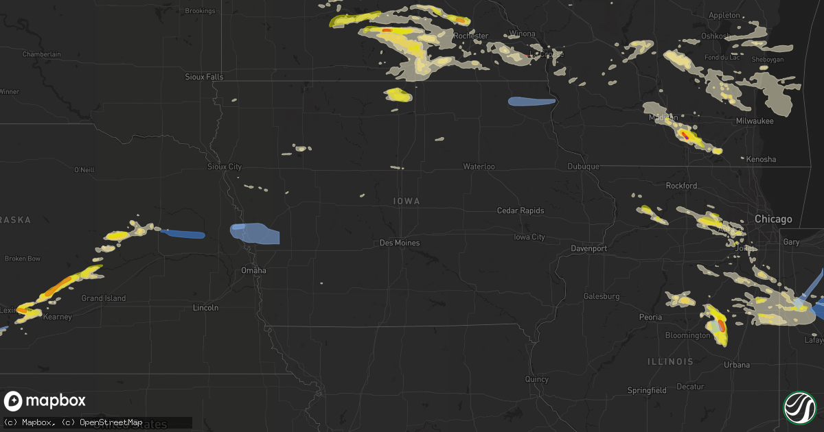
Hail Map in Iowa on July 23, 2022
Get this storm
July 23 map
$229
one time, instant access
Download today. No call, no setup
Keep the $229
Bought the map and want the full workflow? Apply the entire $229 to a subscription within 7 days. None of it is wasted.
Every map, not just this one
This buys you this map. Subscription and you get every map we run, in the markets you choose from a few cities to whole states to nationwide. Plus real-time alerts the moment a storm fires.
Contact data
Name, contact info, occupancy, even credit band for addresses in the footprint. You go from where it hit to who to call.
Become the source they trust
Unlimited branding weather history reports on demand. You already have the documented answer ready for the property owner, and you are the one who showed up with it.
Property data and RoofTrace estimates
Pull up any address you have got, its value and the exact code rules for that jurisdiction, straight from One Click Code. Then RoofTrace estimates the squares, pitch, and roof value, priced the way you price.
Storm reports in Iowa
Iowa
| Date | Description |
|---|---|
| 07/23/20222:18 PM CDT | Few hailstones of half dollar size. |
| 07/23/202211:38 AM CDT | Heavy tree and some building damage on the south side of town. Some of the roof blown off the bank. Power has been off since last night. |
| 07/23/20226:56 AM CDT | At 1156 PM CDT, a severe thunderstorm was located over Winthrop Golf Course, or 7 miles west of Manchester, moving east at 50 mph. HAZARD...60 mph wind gusts. SOURCE...Radar indicated. IMPACT...Expect damage to roofs, siding, and trees. Locations impacted include... Manchester, Dyersville, Edgewood, Earlville, Colesburg, Greeley, Dundee, Delaware, Masonville, Oneida, Delaware County Fairgrounds, Manchester Airport, Coffins Grove Park, Twin Bridges Park, Petersburg and Backbone State Park. |
| 07/23/20226:32 AM CDT | At 1131 PM CDT, severe thunderstorms were located along a line extending from near Fairbank to near Belle Plaine, moving east at 50 mph. HAZARD...60 mph wind gusts. SOURCE...Radar indicated. IMPACT...Expect damage to roofs, siding, and trees. Locations impacted include... Independence, Vinton, Robins, Jesup, Center Point, Urbana, Dysart, Fairbank, Palo, Shellsburg, Winthrop, Hazleton, Walker, Van Horne, Alburnett, Keystone, Quasqueton, Lamont, Garrison and Brandon. |
| 07/23/20225:07 AM CDT | At 1007 PM CDT, a severe thunderstorm was located 11 miles north of Ogden, or 14 miles northwest of Boone, moving east at 55 mph. HAZARD...60 mph wind gusts and penny size hail. SOURCE...Radar indicated. IMPACT...Expect damage to roofs, siding, and trees. Locations impacted include... Story City, Roland, Jewell Junction, Gilbert, Gowrie, Dayton, Stratford, Ellsworth, Stanhope, Harcourt, Paton, Boxholm, Pilot Mound, Randall, Fraser and Dana.This includes Interstate 35 between mile markers 119 and 137. |
| 07/23/20224:55 AM CDT | At 955 PM CDT, a severe thunderstorm was located near Pocahontas, moving east at 50 mph. HAZARD...60 mph wind gusts and quarter size hail. SOURCE...Radar indicated. IMPACT...Hail damage to vehicles is expected. Expect wind damage to roofs, siding, and trees. Locations impacted include... Pocahontas, Dakota City, Humboldt, Laurens, Fonda, Rolfe, Gilmore City, Livermore, Bode, Lu Verne, Thor, Palmer, Havelock, Rutland, Bradgate, Plover, Varina, St. Joseph, Ottosen and Hardy. |
| 07/23/20224:51 AM CDT | At 951 PM CDT, a severe thunderstorm was located near Truesdale, or near Storm Lake, moving east at 35 mph. HAZARD...60 mph wind gusts and quarter size hail. SOURCE...Radar indicated. IMPACT...Hail damage to vehicles is expected. Expect wind damage to roofs, siding, and trees. This severe thunderstorm will be near... Newell around 1000 PM CDT. Albert City around 1005 PM CDT. |
| 07/23/20224:15 AM CDT | At 915 PM CDT, a severe thunderstorm was located over Coon Rapids, or 13 miles northwest of Guthrie Center, moving east at 70 mph. HAZARD...60 mph wind gusts and penny size hail. SOURCE...Radar indicated. IMPACT...Expect damage to roofs, siding, and trees. This severe thunderstorm will be near... Bayard around 920 PM CDT. Lake Panorama, Bagley and Springbrook State Park around 925 PM CDT. Yale, Jamaica and Lakin Slough Game Management Area around 930 PM CDT. Rippey, Dawson and Perry Municipal Airport around 935 PM CDT.Other locations in the path of this severe thunderstorm includePerry.This includes Interstate 80 between mile markers 107 and 112. |
| 07/23/20224:05 AM CDT | At 905 PM CDT, a severe thunderstorm was located near Lake City, or near Rockwell City, moving east at 50 mph. HAZARD...70 mph wind gusts. SOURCE...Radar indicated. IMPACT...Expect considerable tree damage. Damage is likely to mobile homes, roofs, and outbuildings. This severe thunderstorm will be near... Lohrville around 910 PM CDT. Rinard around 915 PM CDT. Farnhamville, Somers and Knierim around 920 PM CDT.Other locations in the path of this severe thunderstorm includeGowrie, Callender and Moorland. |
| 07/23/20223:59 AM CDT | At 858 PM CDT, a severe thunderstorm was located near Harlan, or 18 miles southwest of Audubon, moving east at 40 mph. HAZARD...60 mph wind gusts and penny size hail. SOURCE...Radar indicated. IMPACT...Expect damage to roofs, siding, and trees. This severe thunderstorm will be near... Elk Horn and Kimballton around 915 PM CDT.Other locations in the path of this severe thunderstorm includeBrayton, Audubon, Exira and Audubon County Airport. |
| 07/23/20223:55 AM CDT | At 855 PM CDT, a severe thunderstorm was located 7 miles north of Denison, moving east at 45 mph. HAZARD...60 mph wind gusts and penny size hail. SOURCE...Radar indicated. IMPACT...Expect damage to roofs, siding, and trees. This severe thunderstorm will be near... Vail around 900 PM CDT. Arcadia and Westside around 910 PM CDT. Wall Lake Municipal Airport around 915 PM CDT.Other locations in the path of this severe thunderstorm includeBreda, Carroll and Auburn. |
| 07/23/20223:49 AM CDT | At 849 PM CDT, a severe thunderstorm was located near Black Hawk Lake, or 10 miles southeast of Sac City, moving east at 50 mph. HAZARD...60 mph wind gusts and penny size hail. SOURCE...Trained weather spotters. IMPACT...Expect damage to roofs, siding, and trees. This severe thunderstorm will be near... Lake City around 900 PM CDT.Other locations in the path of this severe thunderstorm includeRockwell City, Lohrville, Rockwell City Municipal Airport, Rinard,Farnhamville, Somers, Knierim, Gowrie, Callender and Moorland. |
| 07/23/20223:38 AM CDT | At 836 PM CDT, severe thunderstorms were located along a line extending from 2 miles north of Woodbine to 6 miles east of Logan to 5 miles northwest of Neola, moving east at 60 mph. THESE ARE DESTRUCTIVE STORMS FOR SHELBY, TENNANT, AND HARLAN. HAZARD...80 mph wind gusts. SOURCE...Emergency management. These storms have a history of producing an 87 mph wind gust in Craig, NE, and a 74 mph wind gust in Tekamah, NE. IMPACT...Flying debris will be dangerous to those caught without shelter. Mobile homes will be heavily damaged. Expect considerable damage to roofs, windows, and vehicles. Extensive tree damage and power outages are likely. Severe thunderstorms will be near... Shelby, Earling and Panama around 850 PM CDT. Harlan, Avoca, Defiance and Hancock around 855 PM CDT.Other locations in the path of these severe thunderstorms includeWalnut and Irwin.People attending East Pottawattamie County Fair Grounds should seeksafe shelter immediately!This includes Interstate 80 in Iowa between mile markers 34 and 48. |
| 07/23/20223:27 AM CDT | At 826 PM CDT, severe thunderstorms were located along a line extending from near Onawa to 4 miles east of Blencoe to 2 miles northwest of Pisgah, moving northeast at 55 mph. HAZARD...70 mph wind gusts. SOURCE...Emergency management. These storms produced a 74 mph wind gust in Tekamah. IMPACT...Expect considerable tree damage. Damage is likely to mobile homes, roofs, and outbuildings. Severe thunderstorms will be near... Moorhead and Castana around 835 PM CDT. Soldier around 840 PM CDT. Mapleton and Ute around 845 PM CDT.This includes Interstate 29 between mile markers 107 and 115. |
| 07/23/20223:20 AM CDT | At 819 PM CDT, severe thunderstorms were located along a line extending from 5 miles east of Tekamah to 4 miles northwest of Modale to 3 miles east of Blair, moving east at 50 mph. THESE ARE DESTRUCTIVE STORMS FOR MONDAMIN, MAGNOLIA, AND MISSOURI VALLEY. HAZARD...80 mph wind gusts. SOURCE...Emergency management. IMPACT...Flying debris will be dangerous to those caught without shelter. Mobile homes will be heavily damaged. Expect considerable damage to roofs, windows, and vehicles. Extensive tree damage and power outages are likely. Severe thunderstorms will be near... Missouri Valley and Pisgah around 830 PM CDT. Logan and Magnolia around 835 PM CDT.Other locations in the path of these severe thunderstorms includeWoodbine, Neola, Persia and Minden.People attending Harrison County Fair should seek safe shelterimmediately!This includes the following highways... Interstate 29 between mile markers 68 and 99. Interstate 80 in Iowa between mile markers 23 and 31. |
| 07/23/202212:53 AM CDT | A local report indicates 67 MPH wind near DUBUQUE REGIONAL ARPT |
| 07/23/202212:48 AM CDT | 3 trees down at this location based on public facebook report. |
| 07/23/202212:48 AM CDT | 2 inch weeping willow sapling snapped in half by storms. |
| 07/23/202212:48 AM CDT | A local report indicates 60 MPH wind near SAGEVILLE |
| 07/23/202212:30 AM CDT | Powerline blown down. |
| 07/23/202212:20 AM CDT | Trees down over roads. |
| 07/23/202212:19 AM CDT | Pictures from twitter shows a few branches near 6 inches down along with the trunk of a tree snapped. Time based on radar. |
| 07/23/202212:15 AM CDT | Power lines down; estimated 1600 people without power. |
| 07/23/202212:15 AM CDT | Power lines down in manchester. |
| 07/23/202212:10 AM CDT | Report of tree down in greeley. Relayed from em. |
| 07/23/202212:02 AM CDT | Reports of power lines down. |
| 07/23/202212:02 AM CDT | Reports of power lines down |
| 07/22/202211:55 PM CDT | Awos station kiib independence arpt. |
| 07/22/202211:45 PM CDT | Small branches down in town along with some minor flooding. |
| 07/22/202211:44 PM CDT | Roof blown off vet clinic. Partial roof blown off a residence. Other businesses in downtown area had some roof damage. Several flagpoles... Trees... And signs blown dow |
| 07/22/202211:42 PM CDT | A farm lost a barn... 2 silos... And 2 power poles. |
| 07/22/202211:41 PM CDT | Deputy estimated at intersection of highways 9 and 51. |
| 07/22/202211:41 PM CDT | Deputy estimated at intersection of highways 9 and 51 |
| 07/22/202211:40 PM CDT | Estimated 50-60 mph and lasted for 5 minutes. |
| 07/22/202211:27 PM CDT | Report of a roof off a house and cars overturned near the northeast iowa community college campus. Time estimated from radar. |
| 07/22/202211:25 PM CDT | Many trees and powerlines down across central winneshiek county from north of decorah to fort atkinson. Time estimated from radar. |
| 07/22/202211:25 PM CDT | Trees down in freeport. Tree completely blocking road near church/cemetery down from wellington. Another in the road but can get through across from recycling center. |
| 07/22/202211:19 PM CDT | At 418 AM CDT, a severe thunderstorm was located over Rock Creek Marina and Campground, or 7 miles southwest of Clinton, moving east at 50 mph. HAZARD...60 mph wind gusts. SOURCE...Radar indicated. IMPACT...Expect damage to roofs, siding, and trees. Locations impacted include... Clinton, Morrison, Camanche, Fulton, Prophetstown, Erie, Garden Plain, Albany, Princeton, Cordova, Lyndon, Low Moor, East Clinton, Union Grove, Ustick, Fenton, Hillsdale, Portland Corners, Folletts and Spring Hill. |
| 07/22/202210:56 PM CDT | 51 knot gust at asos station kmcw mason city airport. |
| 07/22/202210:45 PM CDT | Numerous trees and power lines blown down. |
| 07/22/202210:12 PM CDT | At 312 AM CDT, a severe thunderstorm was located over Zwingle, or 13 miles south of Dubuque, moving east at 50 mph. HAZARD...60 mph wind gusts and quarter size hail. SOURCE...Radar indicated. IMPACT...Hail damage to vehicles is expected. Expect wind damage to roofs, siding, and trees. Locations impacted include... Dubuque, Maquoketa, Galena, Savanna, Bellevue, Stockton, Warren, Hanover, Elizabeth, Woodbine, Sabula, Andrew, Scales Mound, La Motte, Menominee, Springbrook, Council Hill, St. Donatus, Zwingle and Spragueville. |
| 07/22/202210:08 PM CDT | Trees down in neighborhood with power outage. Delayed report... Time estimated via radar. |
| 07/22/20229:47 PM CDT | At 247 PM CDT, severe thunderstorms were located along a line extending from Rushford to near Canton, moving east at 50 mph. HAZARD...60 mph wind gusts and quarter size hail. SOURCE...Radar indicated. IMPACT...Hail damage to vehicles is expected. Expect wind damage to roofs, siding, and trees. Severe thunderstorms will be near... Houston around 300 PM CDT. Spring Grove around 305 PM CDT. Caledonia around 310 PM CDT. La Crescent and Hokah around 315 PM CDT. La Crosse around 320 PM CDT. New Albin around 325 PM CDT.Other locations impacted by these severe thunderstorms include County16 And 4 Corners Drive, Perkins, Mound Prairie, Riceford, County 5And Peyton Road, Money Creek and Newhouse. |
| 07/22/20229:31 PM CDT | At 230 AM CDT, a severe thunderstorm was located over Langworthy, or near Anamosa, moving east at 30 mph. HAZARD...60 mph wind gusts and quarter size hail. SOURCE...Radar indicated. IMPACT...Hail damage to vehicles is expected. Expect wind damage to roofs, siding, and trees. Locations impacted include... Anamosa, Monticello, Cascade, Onslow, Monmouth, Bernard, Center Junction, Nashville, Langworthy, Canton, Baldwin, Emeline, South Gary Owen, Garry Owen, Fillmore, Maquoketa Caves State Park, Ironhills, Washington Mills, Monticello Municipal Airport and Jones County Fairgrounds. |
| 07/22/20229:28 PM CDT | Entire trees down and power out in lake view. Delayed report. |
| 07/22/20229:15 PM CDT | Power poles down east of odebolt... Damage to trees... Grain bin... And shed. Delayed report... Time estimated via radar. |
| 07/22/20229:06 PM CDT | At 205 PM CDT, severe thunderstorms were located along a line extending from near Stewartville to near Adams, moving east at 35 mph. HAZARD...70 mph wind gusts and quarter size hail. SOURCE...Law enforcement reported 70+ mph wind gusts. IMPACT...Hail damage to vehicles is expected. Expect considerable tree damage. Wind damage is also likely to mobile homes, roofs, and outbuildings.Other locations impacted by these severe thunderstorms includeForestville State Park, Choice, York, Isinours, Hutton, Fillmore andPeterson.People attending the Fillmore County Fairgrounds should seek safeshelter immediately!PRECAUTIONARY/PREPAREDNESS ACTIONS...For your protection move to an interior room on the lowest floor of abuilding. |
| 07/22/20229:03 PM CDT | Harlan airport awos measured a peak wind gust of 63 mph. |
| 07/22/20229:02 PM CDT | A local report indicates 69 MPH wind near 1 W DENISON |
| 07/22/20229:00 PM CDT | At 200 AM CDT, a severe thunderstorm was located over Marion, or 7 miles northeast of Cedar Rapids, moving east at 35 mph. HAZARD...60 mph wind gusts and quarter size hail. SOURCE...Radar indicated. IMPACT...Hail damage to vehicles is expected. Expect wind damage to roofs, siding, and trees. Locations impacted include... Cedar Rapids, Anamosa, Marion, Hiawatha, Robins, Springville, Olin, Martelle, Morley, Center Junction, Whittier, Stone City, Viola, Langworthy, Matsell Bridge Natural Area, Wapsipinicon State Park, Squaw Creek Park, Hale, Marion Airport and Scotch Grove. |
| 07/22/20228:45 PM CDT | A local report indicates 60 MPH wind near LAKE VIEW |
| 07/22/20228:33 PM CDT | Trees and branches down. Time estimated from radar. |
| 07/22/20228:30 PM CDT | Emergency management relayed report of downed large trees destroying a couple of houses. |
| 07/22/20228:25 PM CDT | Coop observer estimated wind gusts at 65 to 70 mph and reported tree damage in the area. |
| 07/22/20228:22 PM CDT | At 122 PM CDT, severe thunderstorms were located along a line extending from near Blooming Prairie to near Glenville, moving east at 30 mph. HAZARD...60 mph wind gusts and quarter size hail. SOURCE...Radar indicated. IMPACT...Hail damage to vehicles is expected. Expect wind damage to roofs, siding, and trees. Severe thunderstorms will be near... Austin around 135 PM CDT. Brownsdale around 145 PM CDT. Lyle around 150 PM CDT. Adams around 210 PM CDT. Grand Meadow around 215 PM CDT. Le Roy around 230 PM CDT.Other locations impacted by these severe thunderstorms includeSargeant, County Roads 1 And 7, County Roads 56 And 5, Mapleview,Lansing, Brookside Campground and Mayville.This includes Interstate 90 in Minnesota between mile markers 175 and204. |
All States Impacted by Hail Map on July 23, 2022
Cities Impacted by Hail Map on July 23, 2022
- Byron, MN
- Hayfield, MN
- Stewartville, MN
- Lonsdale, MN
- Montgomery, MN
- Elroy, WI
- Alger, MI
- Gladwin, MI
- Ortley, SD
- Wallace, SD
- Florence, SD
- Stevens Point, WI
- Rudolph, WI
- Grand Haven, MI
- Spring Lake, MI
- Peever, SD
- Webster, SD
- Waubay, SD
- Spring Valley, MN
- Rochester, MN
- Eyota, MN
- Glenbeulah, WI
- Bangor, WI
- Saint Paul, NE
- Wolbach, NE
- Hillsboro, WI
- Wonewoc, WI
- Smithland, IA
- Hornick, IA
- Plainfield, IL
- South Shore, SD
- Milbank, SD
- Marvin, SD
- Ortonville, MN
- Bellingham, MN
- Stockholm, SD
- Marietta, MN
- Goodwin, SD
- Revillo, SD
- Odessa, MN
- Big Stone City, SD
- Labolt, SD
- Watertown, SD
- Summit, SD
- Strandburg, SD
- Twin Brooks, SD
- Hillpoint, WI
- La Valle, WI
- Cazenovia, WI
- Pittsville, WI
- Poynette, WI
- Farwell, NE
- Miller, NE
- Rockville, NE
- Dannebrog, NE
- Boelus, NE
- Ravenna, NE
- Bertrand, NE
- Lexington, NE
- Elm Creek, NE
- Sumner, NE
- Hazard, NE
- Loup City, NE
- Amherst, NE
- Palmer, NE
- Smithfield, NE
- Overton, NE
- Elba, NE
- Ashton, NE
- Pleasanton, NE
- Bowling Green, OH
- Riverdale, NE
- Greensburg, PA
- Jeannette, PA
- Morgan, MN
- Sleepy Eye, MN
- Bristow, IA
- Aredale, IA
- Dumont, IA
- Watertown, WI
- Lake Mills, WI
- Williams, IA
- Northwood, IA
- Bowerston, OH
- Winamac, IN
- Star City, IN
- Kewanna, IN
- Middlebourne, WV
- New Creek, WV
- Grand Meadow, MN
- Racine, MN
- Doon, IA
- Wisconsin Rapids, WI
- West Olive, MI
- Hanley Falls, MN
- Belle Plaine, MN
- Gibbon, MN
- Gaylord, MN
- Madison, MN
- Granite Falls, MN
- Belview, MN
- Morton, MN
- Henderson, MN
- Watson, MN
- Clarkfield, MN
- Echo, MN
- Bird Island, MN
- Montevideo, MN
- Franklin, MN
- Sacred Heart, MN
- Wood Lake, MN
- Maynard, MN
- Arlington, MN
- Winthrop, MN
- Redwood Falls, MN
- Le Sueur, MN
- Dawson, MN
- Danube, MN
- Clara City, MN
- New Prague, MN
- Milan, MN
- Lafayette, MN
- New Ulm, MN
- Olivia, MN
- Renville, MN
- Le Center, MN
- Fairfax, MN
- Saint Peter, MN
- Berlin, WI
- Ripon, WI
- East Tawas, MI
- Friendship, WI
- Mauston, WI
- Wisconsin Dells, WI
- Lyndon Station, WI
- Coloma, WI
- Adams, WI
- Westfield, WI
- Grand Marsh, WI
- Oxford, WI
- Custar, OH
- Weston, OH
- Creola, OH
- Canaan, VT
- Norton, VT
- Averill, VT
- Van Wert, OH
- Middle Point, OH
- Newton, WV
- Left Hand, WV
- Chatfield, MN
- Easton, MN
- Minnesota Lake, MN
- Channahon, IL
- Belle Vernon, PA
- West Newton, PA
- Smithton, PA
- Brillion, WI
- Leechburg, PA
- New Kensington, PA
- Fort Atkinson, WI
- Jefferson, WI
- Newell, IA
- Albert City, IA
- Storm Lake, IA
- Hector, MN
- Beaver Dam, WI
- Stratford, SD
- Andover, SD
- Conde, SD
- Ferney, SD
- Bristol, SD
- Groton, SD
- Mikado, MI
- Greenbush, MI
- New Lisbon, WI
- Whitelaw, WI
- Valders, WI
- Newton, WI
- New Holstein, WI
- Chilton, WI
- Manitowoc, WI
- Saint Nazianz, WI
- Reedsville, WI
- Kiel, WI
- Pittsburg, NH
- Malone, WI
- Saint Cloud, WI
- Lanesboro, MN
- Preston, MN
- Dover, MN
- La Crosse, WI
- Coon Valley, WI
- West Salem, WI
- Stoddard, WI
- Chaseburg, WI
- Winona, MN
- Lewiston, MN
- La Crescent, MN
- Houston, MN
- Caledonia, MN
- Hokah, MN
- Derby Line, VT
- Deerfield, WI
- Marshall, WI
- Salem, WI
- Saukville, WI
- Port Washington, WI
- Random Lake, WI
- Oostburg, WI
- Belgium, WI
- Fredonia, WI
- Kewaskum, WI
- West Bend, WI
- Cedar Grove, WI
- Princeton, WI
- Neshkoro, WI
- Johnson Creek, WI
- Hartford, WI
- Black River Falls, WI
- Schleswig, IA
- Lake Mills, IA
- Fertile, IA
- Joice, IA
- Thompson, IA
- Hanlontown, IA
- Leland, IA
- Forest City, IA
- Everett, PA
- Bedford, PA
- Boyd, MN
- Webster City, IA
- Blairsburg, IA
- Coraopolis, PA
- Sewickley, PA
- Pittsburgh, PA
- Adell, WI
- Campbellsport, WI
- Sheboygan, WI
- Sheboygan Falls, WI
- Chatsworth, IL
- Piper City, IL
- Roberts, IL
- Westby, WI
- Genoa, WI
- Viroqua, WI
- Marion, NC
- Milton, WI
- Avalon, WI
- Mazomanie, WI
- Cross Plains, WI
- Middleton, WI
- Waunakee, WI
- Black Earth, WI
- Lake Geneva, WI
- Stoughton, WI
- Delavan, WI
- Edgerton, WI
- Whitewater, WI
- Janesville, WI
- Elkhorn, WI
- Oregon, WI
- Madison, WI
- Deforest, WI
- Sauk City, WI
- Dane, WI
- Lodi, WI
- Mcfarland, WI
- Cambridge, WI
- Cottage Grove, WI
- Broadway, NC
- Lillington, NC
- Wheaton, IL
- Lindsay, NE
- Saint Edward, NE
- Newman Grove, NE
- Primrose, NE
- Madison, NE
- Albion, NE
- Spalding, NE
- Humphrey, NE
- Cedar Rapids, NE
- Marquette, WI
- Dalton, WI
- Montello, WI
- Kingston, WI
- Markesan, WI
- Randolph, WI
- Buckhorn, KY
- Oneida, KY
- Greenup, KY
- Burgettstown, PA
- Georgetown, PA
- Moorefield, WV
- Mount Gilead, OH
- Cardington, OH
- Riverton, WV
- Upper Tract, WV
- Seneca Rocks, WV
- Flatwoods, WV
- Ohio City, OH
- Old Fields, WV
- Baker, WV
- Fisher, WV
- Rio, WV
- Webbville, KY
- Grayson, KY
- Sandy Hook, KY
- Pine Island, MN
- Olive Hill, KY
- Vanceburg, KY
- Emerson, KY
- Nebo, NC
- New Haven, IN
- Fort Wayne, IN
- Monroeville, IN
- Delphos, OH
- Glenshaw, PA
- Pontiac, IL
- Lamar, CO
- Chenoa, IL
- McCook, NE
- Letart, WV
- Hartford, WV
- Racine, OH
- Pomeroy, OH
- Syracuse, OH
- New Haven, WV
- Mason, WV
- Mount Pleasant, SC
- Cooksville, IL
- Colfax, IL
- Arrowsmith, IL
- Anchor, IL
- Foosland, IL
- Forrest, IL
- Gibson City, IL
- Bellflower, IL
- Cropsey, IL
- Saybrook, IL
- Fairbury, IL
- Lexington, IL
- Sibley, IL
- Fisher, IL
- Strawn, IL
- Petersburg, WV
- Ashland, KY
- Garrison, KY
- Rush, KY
- Argillite, KY
- Buckley, IL
- Bulger, PA
- Vanlue, OH
- Carey, OH
- Findlay, OH
- Alvada, OH
- Rayland, OH
- Yorkville, OH
- Tiltonsville, OH
- Decatur, IN
- Newport, OH
- Leicester, NC
- Alexander, NC
- Charleston, TN
- Cameron, NC
- Sanford, NC
- Vass, NC
- Eagle Rock, VA
- Helenwood, TN
- Oneida, TN
- Claremont, MN
- Dodge Center, MN
- Eustis, NE
- Fuquay Varina, NC
- Louisa, KY
- Bowling Green, KY
- Utica, MN
- Peterson, MN
- Wanamingo, MN
- West Concord, MN
- Seminole, FL
- Saint Petersburg, FL
- Clearwater, FL
- Largo, FL
- Pinellas Park, FL
- Kasota, MN
- Morehead, KY
- Salt Lick, KY
- Tampa, FL
- Manchester, KY
- Irwin, PA
- Adamsburg, PA
- Odessa, FL
- New Port Richey, FL
- Land O'Lakes, FL
- Sheldon, IL
- Crescent City, IL
- Milford, IL
- Fowler, IN
- Onarga, IL
- Watseka, IL
- Earl Park, IN
- Stockland, IL
- Cissna Park, IL
- Hubertus, WI
- Richfield, WI
- Colebrook, NH
- Owatonna, MN
- Blooming Prairie, MN
- Fenwick, MI
- Sheridan, MI
- Walterboro, SC
- Genoa, WV
- Wayne, WV
- Prichard, WV
- Fort Gay, WV
- Jacksonburg, WV
- Smithfield, WV
- Oldtown, MD
- Green Spring, WV
- Springfield, WV
- Fort Ashby, WV
- Levels, WV
- Burlington, WV
- Keyser, WV
- Romney, WV
- Olympia, KY
- Kingstree, SC
- Nesmith, SC
- Ronda, NC
- Roaring River, NC
- Hamptonville, NC
- Jonesville, NC
- Hayward, MN
- Waldorf, MN
- Brownsdale, MN
- Pemberton, MN
- Good Thunder, MN
- Eagle Lake, MN
- Hollandale, MN
- Mankato, MN
- Lansing, MN
- Waseca, MN
- Mapleton, MN
- Clarks Grove, MN
- Austin, MN
- Albert Lea, MN
- Geneva, MN
- Dexter, MN
- Janesville, MN
- Hartland, MN
- New Richland, MN
- Ellendale, MN
- Saint Clair, MN
- Glenville, MN
- Hoagland, IN
- Payne, OH
- Fort Jennings, OH
- Peotone, IL
- East Waterford, PA
- Blairs Mills, PA
- Shade Gap, PA
- Orbisonia, PA
- West Jefferson, NC
- Bourbonnais, IL
- Pembroke Township, IL
- Grant Park, IL
- Kankakee, IL
- Manteno, IL
- Wilmington, IL
- Manhattan, IL
- Momence, IL
- State Road, NC
- Elkin, NC
- Middlesboro, KY
- Winkelman, AZ
- Seneca, IL
- Ransom, IL
- Remington, IN
- Minooka, IL
- Continental, OH
- Ottawa, OH
- Albany, OH
- Arcadia, FL
- Fox Lake, WI
- Kenyon, MN
- Mapleton, IA
- Oto, IA
- Brilliant, OH
- Mingo Junction, OH
- Wellsburg, WV
- Lane, SC
- Andrews, SC
- Hillsboro, OH
- Alum Bridge, WV
- Troy, WV
- Linn, WV
- Coxs Mills, WV
- Fostoria, OH
- Kansas, OH
- Sardis, OH
- Wingett Run, OH
- New Matamoras, OH
- Graysville, OH
- Marietta, OH
- Portland, OH
- Maple Park, IL
- Point Pleasant, WV
- Slinger, WI
- Germantown, WI
- Lomira, WI
- Menomonee Falls, WI
- Allenton, WI
- Mayville, WI
- Iron Ridge, WI
- Theresa, WI
- Hustisford, WI
- Neosho, WI
- Jackson, WI
- Lannon, WI
- Horicon, WI
- Milwaukee, WI
- Rubicon, WI
- Burnett, WI
- Brownsville, WI
- Colgate, WI
- Sussex, WI
- Juneau, WI
- New Martinsville, WV
- Lewisburg, WV
- Maxwelton, WV
- Ivel, KY
- Gilman, IL
- Ashkum, IL
- Dana, IA
- Paton, IA
- Allison Park, PA
- Martinsburg, WV
- Kearneysville, WV
- Shepherdstown, WV
- New Vienna, OH
- Leesburg, OH
- Sabina, OH
- Rushford, MN
- Mount Pleasant, PA
- Kernersville, NC
- High Point, NC
- Herminie, PA
- Darragh, PA
- New Stanton, PA
- Arona, PA
- Medford, MN
- Faribault, MN
- Morganton, NC
- Deshler, OH
- Lake Crystal, MN
- Whiteriver, AZ
- Tazewell, VA
- Bastian, VA
- Bryson City, NC
- Overgaard, AZ
- Madison Lake, MN
- Newberry, FL
- Pioneer, TN
- La Follette, TN
- Savannah, GA
- Oronoco, MN
- Mazeppa, MN
- Oswego, IL
- Aurora, IL
- Bolingbrook, IL
- Montgomery, IL
- Naperville, IL
- Winfield, TN
- Prestonsburg, KY
- Cabins, WV
- Salyersville, KY
- West Liberty, KY
- Rensselaer, IN
- Valley Grove, WV
- West Alexander, PA
- Dallas, WV
- Triadelphia, WV
- West Finley, PA
- Tiffin, OH
- Rochelle, IL
- New Riegel, OH
- Franklin Grove, IL
- Dixon, IL
- Sistersville, WV
- Lutz, FL
- Hanska, MN
- Eidson, TN
- Walden, CO
- Batavia, IL
- Lisle, IL
- North Aurora, IL
- Warrenville, IL
- Whitesburg, KY
- Mallie, KY
- Isom, KY
- Premium, KY
- North Charleston, SC
- Charleston, SC
- Romeoville, IL
- Lockport, IL
- Crest Hill, IL
- Roaring Gap, NC
- Indianola, NE
- Corning, IA
- Jackson, KY
- Hueysville, KY
- Vest, KY
- Jamestown, TN
- Clarkrange, TN
- Dunlow, WV
- Rutland, IL
- North Wilkesboro, NC
- Venice, FL
- Francesville, IN
- Hedgesville, WV
- West Lafayette, IN
- Reddick, IL
- Toluca, IL
- Minonk, IL
- Washburn, IL
- Peridot, AZ
- Port Charlotte, FL
- Saint Anne, IL
- Beaverville, IL
- Friendly, WV
- Homer Glen, IL
- Benson, IL
- Roanoke, IL
- Dana, IL
- Lowpoint, IL
- Varna, IL
- Flanagan, IL
- Lacon, IL
- El Paso, IL
- Metamora, IL
- Aroma Park, IL
- Fair Oaks, IN
- Donovan, IL
- Union Hill, IL
- Martinton, IL
- Braceville, IL
- Wolcott, IN
- Bonfield, IL
- Braidwood, IL
- Monon, IN
- Buckingham, IL
- Goodland, IN
- Clifton, IL
- Kempton, IL
- Herscher, IL
- Brookston, IN
- Reynolds, IN
- Gardner, IL
- Chebanse, IL
- Kentland, IN
- South Wilmington, IL
- Mazon, IL
- Essex, IL
- Brook, IN
- Chalmers, IN
- Danforth, IL
- Iroquois, IL
- Cullom, IL
- Morocco, IN
- Jacksonville, FL
- Yulee, FL
- Huger, SC
- Saint Charles, MN
- Truesdale, IA
- Alta, IA
- Northfield, MN
- Zumbro Falls, MN
- Nerstrand, MN
- Lafayette, IN
- Morris, IL
- Coal City, IL
- Little Orleans, MD
- Big Cove Tannery, PA
- Hancock, MD
- Needmore, PA
- Mercersburg, PA
- Great Cacapon, WV
- Berkeley Springs, WV
- Warfordsburg, PA
- Republic, OH
- Avella, PA
- Colliers, WV
- Creston, NE
- Britt, IA
- Garner, IA
- New Cumberland, WV
- Hilbert, WI
- Mount Morris, IL
- Oregon, IL
- Polo, IL
- Monticello, IN
- Englewood, FL
- Nokomis, FL
- North Port, FL
- Hundred, WV
- New Freeport, PA
- Littleton, WV
- Napoleon, OH
- Clinton, PA
- Onalaska, WI
- Henrico, VA
- Glen Allen, VA
- Readstown, WI
- Homosassa, FL
- Willshire, OH
- Wren, OH
- London, KY
- Hudson, FL
- Spring Hill, FL
- Crystal River, FL
- Inverness, FL
- Carthage, NC
- West End, NC
- Nicollet, MN
- Garden City, MN
- Saint James, MN
- Hope, MN
- Courtland, MN
- Emmons, MN
- Conger, MN
- Kasson, MN
- Twin Lakes, MN
- Warsaw, MN
- Waterville, MN
- Ostrander, MN
- Kiester, MN
- Sargeant, MN
- Morristown, MN
- Bricelyn, MN
- Madelia, MN
- Cleveland, MN
- Wells, MN
- Elkton, MN
- Waltham, MN
- Wykoff, MN
- Elysian, MN
- Mantorville, MN
- Alden, MN
- Union Grove, NC
- Cleveland, WI
- Frankfort, IL
- Joliet, IL
- Elwood, IL
- Mokena, IL
- New Lenox, IL
- Clearville, PA
- Saint Marys, OH
- Wapakoneta, OH
- Purgitsville, WV
- Benton, TN
- Reliance, TN
- Mount Calvary, WI
- Green Lake, WI
- Cambria, WI
- Waupun, WI
- Elkhart Lake, WI
- Fremont, OH
- Pittsboro, NC
- Todd, NC
- Weaverville, NC
- Adel, GA
- Blountstown, FL
- Dakota, MN
- Danbury, IA
- Clear Lake, SD
- Gary, SD
- Shannon, IL
- Lanark, IL
- Cortland, IL
- Big Rock, IL
- Sugar Grove, IL
- Mooseheart, IL
- Malta, IL
- Bristol, IL
- Sycamore, IL
- Waterman, IL
- Dekalb, IL
- Plano, IL
- Esmond, IL
- Chana, IL
- Hinckley, IL
- Yorkville, IL
- Shabbona, IL
- Elburn, IL
- Hampshire, IL
- Aurelia, IA
- Convoy, OH
- Kilkenny, MN
- Springfield, OH
- Archbold, OH
- Lake Village, IN
- Latrobe, PA
- Morgantown, WV
- Viper, KY
- Smilax, KY
- Hazard, KY
- Holland, MI
- Zeeland, MI
- Hudsonville, MI
- Greeley, NE
- Spruce Pine, NC
- Burnsville, NC
- Moorefield, NE
- Elwood, NE
- Winston Salem, NC
- Raton, NM
- Fernandina Beach, FL
- Viola, WI
- Allardt, TN
- Breezewood, PA
- Crystal Spring, PA
- Meadow Grove, NE
- Dillwyn, VA
- Singer, LA
- Mount Nebo, WV
- Glen Saint Mary, FL
- Vienna, WV
- Hays, NC
- Arcadia, OH
- North Baltimore, OH
- Van Buren, OH
- Bloomdale, OH
- Avonmore, PA
- Wewahitchka, FL
- Arcola, IN
- Livingston, LA
- Ruffin, SC
- Hillsboro, KY
- Larwill, IN
- Pierceton, IN
- South Whitley, IN
- Milledgeville, IL
- Woosung, IL
- Verona, IL
- Ottawa, IL
- Marseilles, IL
- Grand Ridge, IL
- Kinsman, IL
- Pikeville, KY
- Wytheville, VA
- Dublin, VA
- Fountain, MN
- Huntsville, TN
- Rollingstone, MN
- Altura, MN
- Green Isle, MN
- Sun Prairie, WI
- Burton, WV
- New Alexandria, PA
- Dexter City, OH
- Macksburg, OH
- Upper Sandusky, OH
- Harpster, OH
- McDonald, PA
- Midway, PA
- Sycamore, PA
- Prosperity, PA
- Graysville, PA
- Morral, OH
- Marion, OH
- Urbana, OH
- Dundas, MN
- Buffalo Lake, MN
- Stewart, MN
- Holdrege, NE
- Medaryville, IN
- Wheatfield, IN
- North Judson, IN
- La Crosse, IN
- San Pierre, IN
- Raymond, MN
- Prinsburg, MN
- North Freedom, WI
- Friesland, WI
- Baraboo, WI
- Norwalk, WI
- Ontario, WI
- Portage, WI
- Sparta, WI
- Pardeeville, WI
- Reedsburg, WI
- Endeavor, WI
- Camp Douglas, WI
- Merrimac, WI
- Briggsville, WI
- Brownsville, MN
- La Farge, WI
- Richland Center, WI
- Wilton, WI
- Rose Creek, MN
- Rockland, WI
- Cashton, WI
- Holmen, WI
- Kendall, WI
- Rock Springs, WI
- Appleton, WI
- Greenville, WI
- Poy Sippi, WI
- Fremont, WI
- Wautoma, WI
- Kaukauna, WI
- Omro, WI
- Black Creek, WI
- Menasha, WI
- Wrightstown, WI
- Oneida, WI
- Redgranite, WI
- Neenah, WI
- Seymour, WI
- Green Bay, WI
- Butte Des Morts, WI
- Pickett, WI
- Winneconne, WI
- Combined Locks, WI
- Forest Junction, WI
- Larsen, WI
- Kimberly, WI
- Little Chute, WI
- Oshkosh, WI
- Hortonville, WI
- De Pere, WI
- Greenleaf, WI
- Pine River, WI
- Sherwood, WI
- Waterloo, WI
- Mount Horeb, WI
- Belleville, WI
- Verona, WI
- Palmyra, WI
- Amsterdam, OH
- Hammondsville, OH
- Bergholz, OH
- Salineville, OH
- Irondale, OH
- Carrollton, OH
- Mineral City, OH
- Sherrodsville, OH
- Dennison, OH
- Scio, OH
- Mechanicstown, OH
- New Philadelphia, OH
- Uhrichsville, OH
- Middleport, OH
- Cheshire, OH
- Bidwell, OH
- Rutland, OH
- West Columbia, WV
- Long Bottom, OH
- Ravenswood, WV
- Wheeling, WV
- West Liberty, WV
- Bethany, WV
- Howells, NE
- Dodge, NE
- Clarkson, NE
- Leigh, NE
- Scribner, NE
- Snyder, NE
- Kirkman, IA
- Little Sioux, IA
- Blair, NE
- Magnolia, IA
- Pisgah, IA
- Portsmouth, IA
- Modale, IA
- Missouri Valley, IA
- Logan, IA
- Woodbine, IA
- Mondamin, IA
- Persia, IA
- Shelby, IA
- Tekamah, NE
- Harlan, IA
- Herman, NE
- Panama, IA
- Garden City, SD
- Aberdeen, SD
- Turton, SD
- Warner, SD
- Clark, SD
- Mellette, SD
- Bradley, SD
- Bath, SD
- Raymond, SD
- Brentford, SD
- Mansfield, SD
- Henry, SD
- Cheswick, PA
- Monroeville, PA
- West Mifflin, PA
- Russellton, PA
- Murrysville, PA
- Tarentum, PA
- Harwick, PA
- Oakmont, PA
- Springdale, PA
- Mckeesport, PA
- Turtle Creek, PA
- Glassport, PA
- Indianola, PA
- Verona, PA
- East Pittsburgh, PA
- Clairton, PA
- East McKeesport, PA
- Braddock, PA
- McKees Rocks, PA
- Wilmerding, PA
- Dravosburg, PA
- Duquesne, PA
- Creighton, PA
- North Versailles, PA
- Homestead, PA
- Trafford, PA
- Pitcairn, PA
- Waukon, IA
- Waterville, IA
- Lansing, IA
- Postville, IA
- Calmar, IA
- Decorah, IA
- Harpers Ferry, IA
- Comfrey, MN
- Zumbrota, MN
- Troy, OH
- Allendale, MI
- Grandville, MI
- Coopersville, MI
- Ravenna, MI
- Conklin, MI
- Nunica, MI
- Marne, MI
- Jenison, MI
- Muskegon, MI
- Grand Rapids, MI
- Wyoming, MI
- Comstock Park, MI
- Fruitport, MI
- Sparta, MI
- Jefferson, NC
- Maysville, WV
- Bryant, IN
- Saint Paris, OH
- Twelve Mile, IN
- West Milton, OH
- Onward, IN
- Hartford City, IN
- Ludlow Falls, OH
- Bluffton, IN
- Fletcher, OH
- Christiansburg, OH
- Peru, IN
- Matthews, IN
- Celina, OH
- Sweetser, IN
- Tipp City, OH
- Palestine, OH
- Clayton, OH
- Conover, OH
- Albany, IN
- Galveston, IN
- Mexico, IN
- Pleasant Hill, OH
- Hollansburg, OH
- Pennville, IN
- Arcanum, OH
- Van Buren, IN
- Greenville, OH
- Swayzee, IN
- Pitsburg, OH
- Englewood, OH
- Versailles, OH
- Greentown, IN
- La Fontaine, IN
- Yorkshire, OH
- Marion, IN
- Union City, IN
- Poneto, IN
- Walton, IN
- Jonesboro, IN
- Burkettsville, OH
- Fountain City, IN
- Ridgeville, IN
- Burnettsville, IN
- Eaton, IN
- Redkey, IN
- Lewisburg, OH
- Royal Center, IN
- Union City, OH
- Muncie, IN
- Fort Recovery, OH
- Idaville, IN
- Verona, OH
- Osgood, OH
- Keystone, IN
- Portland, IN
- Alexandria, IN
- West Manchester, OH
- Salamonia, IN
- Fort Loramie, OH
- Wabash, IN
- New Paris, OH
- Summitville, IN
- Houston, OH
- Bradford, OH
- Sharpsville, IN
- Saint Henry, OH
- Miami, IN
- Petroleum, IN
- Fowlerton, IN
- Warren, IN
- Rossburg, OH
- Richmond, IN
- Logansport, IN
- Dunkirk, IN
- New Waverly, IN
- New Madison, OH
- Berne, IN
- Russia, OH
- Lucerne, IN
- Ansonia, OH
- Bunker Hill, IN
- Casstown, OH
- Delphi, IN
- Kokomo, IN
- Amboy, IN
- New Weston, OH
- Bringhurst, IN
- Saratoga, IN
- Winchester, IN
- Farmland, IN
- Fairmount, IN
- Laura, OH
- Grissom Arb, IN
- Buffalo, IN
- Covington, OH
- Flora, IN
- Coldwater, OH
- Converse, IN
- Dayton, OH
- Gas City, IN
- Upland, IN
- Piqua, OH
- Phillipsburg, OH
- Yeoman, IN
- Camden, IN
- Brookville, OH
- Elwood, IN
- Montpelier, IN
- Russiaville, IN
- Gaston, IN
- New Carlisle, OH
- Geneva, IN
- Maria Stein, OH
- Lynn, IN
- Vandalia, OH
- Eldorado, OH
- Gettysburg, OH
- Young America, IN
- Yoder, IN
- Zanesville, IN
- Ossian, IN
- Columbia City, IN
- Huntington, IN
- Roanoke, IN
- Uniondale, IN
- Markle, IN
- Lima, OH
- Mendon, OH
- Spencerville, OH
- Rockford, OH
- Venedocia, OH
- Litchfield, NE


