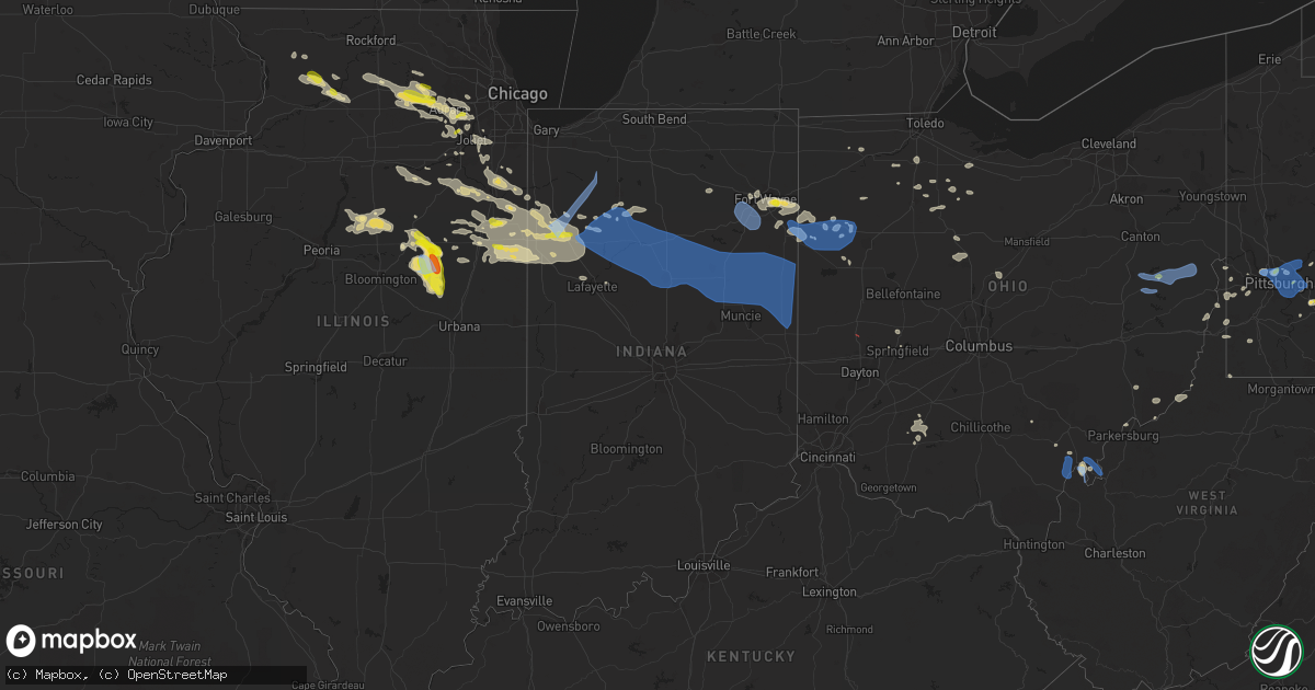
Hail Map in Indiana on July 23, 2022
Get this storm
July 23 map
$229
one time, instant access
Download today. No call, no setup
Keep the $229
Bought the map and want the full workflow? Apply the entire $229 to a subscription within 7 days. None of it is wasted.
Every map, not just this one
This buys you this map. Subscription and you get every map we run, in the markets you choose from a few cities to whole states to nationwide. Plus real-time alerts the moment a storm fires.
Contact data
Name, contact info, occupancy, even credit band for addresses in the footprint. You go from where it hit to who to call.
Become the source they trust
Unlimited branding weather history reports on demand. You already have the documented answer ready for the property owner, and you are the one who showed up with it.
Property data and RoofTrace estimates
Pull up any address you have got, its value and the exact code rules for that jurisdiction, straight from One Click Code. Then RoofTrace estimates the squares, pitch, and roof value, priced the way you price.
Storm reports in Indiana
Indiana
| Date | Description |
|---|---|
| 07/23/202212:00 PM CDT | Trees and power lines down. |
| 07/23/202211:36 AM CDT | Report from mping: quarter |
| 07/23/20229:29 AM CDT | A couple of medium-sized branches down. Photo verified. Time estimated from radar. |
| 07/23/20229:25 AM CDT | 8 trees down scattered througout wayne county. All reports north of i-70. Time estimated from radar. |
| 07/23/20229:21 AM CDT | Numerous reports of trees and power lines down across hamilton county. |
| 07/23/20229:21 AM CDT | Large tree down on us35 and round barn. Time estimated from radar. |
| 07/23/20229:19 AM CDT | Large tree down on washington street. Time estimated from radar. |
| 07/23/20229:11 AM CDT | Report from mping: 3-inch tree limbs broken; power poles broken. |
| 07/23/20229:10 AM CDT | Report from mping: 1-inch tree limbs broken; shingles blown off. |
| 07/23/20229:05 AM CDT | Various locations have limbs down in the northern part of county |
| 07/23/20229:00 AM CDT | Numerous reports of trees and power lines reported down across the county. |
| 07/23/20228:25 AM CDT | Tree down on power line. Time estimated from radar. |
| 07/23/20228:22 AM CDT | Heard on scanner report of tree on house and power lines. |
| 07/23/20228:21 AM CDT | Report from mping: 1-inch tree limbs broken; shingles blown off. |
| 07/23/20228:20 AM CDT | Heard over scanner reports of trees down and debris in roadway. |
| 07/23/20228:13 AM CDT | Report from mping: 1-inch tree limbs broken; shingles blown off. |
| 07/23/20227:56 AM CDT | A local report indicates 62 MPH wind near GRISSOM AFB |
| 07/23/20227:55 AM CDT | Monticello white county airport. |
| 07/23/20227:44 AM CDT | Multiple trees down on 1500 block of 3rd st in logansport. Time estimated from radar. |
| 07/23/20227:44 AM CDT | Trees and powerlines over road. Time estimated from radar. |
| 07/23/20227:42 AM CDT | At 1242 PM EDT, a severe thunderstorm was located over Perkins, moving east at 35 mph. HAZARD...60 mph wind gusts and quarter size hail. SOURCE...Radar indicated. IMPACT...Hail damage to vehicles is expected. Expect wind damage to roofs, siding, and trees. Locations impacted include... Monticello, Monon, Wolcott, Reynolds, Chalmers, Burnettsville, Smithson, Headlee, Golden Hill, Indiana Beach, Norway, Idaville, Sitka, Cedar Point, Bell Center and Buffalo.This includes Interstate 65 between mile markers 191 and 198. |
| 07/23/20227:35 AM CDT | Report from mping: golf ball. |
| 07/23/20227:30 AM CDT | Roof off a house... Damage to another house from fallen trees. Crop damage in numerous locations. Time estimated from radar. |
| 07/23/20227:30 AM CDT | Tree down. Time estimated from radar. |
| 07/23/20227:27 AM CDT | Tree down. Time estimated from radar. |
| 07/23/20227:25 AM CDT | Trees and utility lines down. Time estimated from radar. |
| 07/23/20227:25 AM CDT | Tree down. Time estimated from radar. |
| 07/23/20227:25 AM CDT | Tree down. Time estimated from radar. |
| 07/23/20227:20 AM CDT | Tree down. Time estimated from radar. |
| 07/23/20227:15 AM CDT | Tree down. Time estimated from radar. |
| 07/23/20227:10 AM CDT | Health 10 inch diameter tree limb broke. Via facebook. |
| 07/23/20227:00 AM CDT | Measured 67 mph wind gust with a mobile anemometer at the intersection of sr 10 and 49 in wheatfield. |
| 07/23/20226:37 AM CDT | At 1137 AM CDT, a severe thunderstorm was located near Remington, moving east at 40 mph. HAZARD...60 mph wind gusts and quarter size hail. SOURCE...Radar indicated. IMPACT...Hail damage to vehicles is expected. Expect wind damage to roofs, siding, and trees. Locations impacted include... Remington.Including the following interstate... Indiana I-65 between mile markers 200 and 209. |
| 07/23/20224:12 AM CDT | At 912 AM EDT, a severe thunderstorm was located near Kokomo, moving southeast at 55 mph. HAZARD...60 mph wind gusts. SOURCE...Radar indicated. IMPACT...Expect damage to roofs, siding, and trees. This severe thunderstorm will be near... Tipton and Windfall around 920 AM EDT. Elwood around 930 AM EDT.Other locations in the path of this severe thunderstorm includeOrestes, Alexandria and Frankton. |
| 07/23/20224:04 AM CDT | At 904 AM EDT, severe thunderstorms were located along a line extending from near Andrews to near La Fontaine to near Kokomo, moving south at 40 mph. HAZARD...70 mph wind gusts. SOURCE...Radar indicated. IMPACT...Expect considerable tree damage. Damage is likely to mobile homes, roofs, and outbuildings. Locations impacted include... Marion, Huntington, Wabash, Hartford City, Gas City, Upland, Fairmount, Grissom Afb, Montpelier, Jonesboro, Sweetser, Andrews, Swayzee, Bunker Hill, La Fontaine, Van Buren, Matthews, Lincoln, Sims and Galveston.This includes Interstate 69 in Indiana between mile markers 252 and279. |
| 07/23/20223:40 AM CDT | At 839 AM EDT, a severe thunderstorm was located 7 miles east of Monticello, moving southeast at 45 mph. HAZARD...60 mph wind gusts. SOURCE...Radar indicated. IMPACT...Expect damage to roofs, siding, and trees. This severe thunderstorm will be near... Camden around 850 AM EDT.Other locations in the path of this severe thunderstorm includeKokomo.This includes Interstate 65 between mile markers 175 and 184. |
| 07/23/20223:08 AM CDT | At 808 AM EDT/708 AM CDT/, severe thunderstorms were located along a line extending from near North Judson to near Medaryville to Brook, moving southeast at 45 mph. HAZARD...60 mph wind gusts and penny size hail. SOURCE...Radar indicated. IMPACT...Expect damage to roofs, siding, and trees. Locations impacted include... Logansport, Rochester, Monticello, Winamac, Monon, North Judson, Brookston, Akron, Wolcott, Francesville, Royal Center, Medaryville, Pulaski, Ripley, Kewanna, Reynolds, Chalmers, Burnettsville, Fulton and Macy.This includes Interstate 65 between mile markers 185 and 198. |
| 07/23/20222:53 AM CDT | At 753 AM EDT, severe thunderstorms were located along a line extending from near Topeka to near Tri-lakes to near North Manchester, moving southeast at 40 mph. HAZARD...70 mph wind gusts. SOURCE...Radar indicated. IMPACT...Expect considerable tree damage. Damage is likely to mobile homes, roofs, and outbuildings. Locations impacted include... Fort Wayne, Huntington, Warsaw, Auburn, Kendallville, Columbia City, Garrett, North Manchester, Winona Lake, Ligonier, Tri-lakes, Huntertown, Avilla, Albion, Churubusco, South Whitley, Rome City, North Webster, Pierceton and Aboite.This includes the following highways... Interstate 469 near mile marker 0, between mile markers 2 and 3, andbetween mile markers 7 and 8, and near mile marker 30. Interstate 69 in Indiana near mile marker 291, and between milemarkers 294 and 329. |
| 07/23/20222:25 AM CDT | At 725 AM EDT/625 AM CDT/, severe thunderstorms were located along a line extending from near Bourbon to near Culver to near North Judson, moving southeast at 20 mph. HAZARD...60 mph wind gusts and quarter size hail. SOURCE...Radar indicated. IMPACT...Hail damage to vehicles is expected. Expect wind damage to roofs, siding, and trees. Locations impacted include... Plymouth, Rochester, Knox, Winamac, North Judson, Argos, Culver, Mentone, Hamlet, Koontz Lake, Walnut, Tippecanoe, Oak Grove, Ripley, La Paz, Claypool, Monterey, Burket, Lomax and Beardstown. |
| 07/23/20222:16 AM CDT | At 716 AM EDT, severe thunderstorms were located along a line extending from near Middlebury to near Bourbon, moving east at 45 mph. HAZARD...70 mph wind gusts. SOURCE...Radar indicated. IMPACT...Expect considerable tree damage. Damage is likely to mobile homes, roofs, and outbuildings. Locations impacted include... Warsaw, Kendallville, Columbia City, Nappanee, Winona Lake, Bremen, Ligonier, Syracuse, Tri-lakes, Albion, Bourbon, Milford, Rome City, North Webster, Pierceton, Etna, Wolcottville, Etna Green, Leesburg and Cromwell. |
| 07/23/20221:57 AM CDT | At 657 AM EDT, severe thunderstorms were located along a line extending from near Edwardsburg to near Osceola to near Bremen, moving east at 50 mph. HAZARD...60 mph wind gusts and penny size hail. SOURCE...Radar indicated. IMPACT...Expect damage to roofs, siding, and trees. Locations impacted include... South Bend, Elkhart, Mishawaka, Goshen, Niles, Sturgis, Nappanee, Bremen, Ligonier, Georgetown, Syracuse, Lagrange, Gulivoire Park, Granger, Dunlap, Simonton Lake, Middlebury, Osceola, Constantine and Wakarusa.This includes Interstate 80 in Indiana between mile markers 72 and121. |
| 07/23/20221:34 AM CDT | At 634 AM EDT/534 AM CDT/, a severe thunderstorm was located near La Porte, moving southeast at 30 mph. HAZARD...60 mph wind gusts and half dollar size hail. SOURCE...Radar indicated. IMPACT...Hail damage to vehicles is expected. Expect wind damage to roofs, siding, and trees. Locations impacted include... Plymouth, Knox, Walkerton, North Liberty, Kingsford Heights, Wanatah, Hamlet, La Crosse, Koontz Lake, Oak Grove, Hanna, La Paz, Kingsbury, Lomax, Ober, Teegarden, English Lake, Salem Heights, Fish Lake and Brems. |
| 07/23/20221:20 AM CDT | At 620 AM CDT, severe thunderstorms were located along a line extending from Portage to near Beecher to 6 miles south of Lakewood Shores, moving southeast at 55 mph. These storms have a history of producing wind damage. HAZARD...60 mph wind gusts. SOURCE...Radar indicated. IMPACT...Expect damage to roofs, siding, and trees. Locations impacted include... Hammond, Gary, Portage, Merrillville, East Chicago, Schererville, Hobart, Kankakee, Crown Point, Highland, Munster, Bourbonnais, Bradley, Cedar Lake, Lowell, Manteno, Momence, Herscher, Lake Village and Griffith.Including the following interstates... I-57 between mile markers 303 and 324. Indiana I-80 between mile markers 1 and 15. Indiana I-90 between mile markers 3 and 21. Indiana I-94 near mile marker 16. Indiana I-65 between mile markers 233 and 261.This includes... Indiana University Northwest, Purdue UniversityNorthwest Hammond, Illiana Motor Speedway, Kankakee CommunityCollege, Kankakee County Fairgrounds and Speedway, Kankakee RiverState Park, Lake County Fairgrounds, Olivet Nazarine University, andSouth Shore Rail Cats Baseball. |
| 07/23/202212:29 AM CDT | At 528 AM CDT, severe thunderstorms were located along a line extending from Edgewater to Maywood to Lisle, moving southeast at 35 mph. O'Hare airport gusted to 58 mph with these storms. HAZARD...60 mph wind gusts and quarter size hail. SOURCE...Surface observations. IMPACT...Hail damage to vehicles is expected. Expect wind damage to roofs, siding, and trees. Locations impacted include... Chicago, Aurora, Joliet, Naperville, Hammond, Bolingbrook, Orland Park, Tinley Park, Oak Lawn, Berwyn, Wheaton, Downers Grove, Lombard, Romeoville, Plainfield, Calumet City, Woodridge, Chicago Heights, Chicago Lawn and Englewood.This includes... Argonne National Laboratory, Brookfield Zoo,SeatGeek Stadium, University of St. Francis, Windy City ThunderboltsBaseball, Benedictine University, Channahon State Park, ChicagolandSpeedway...Route 66 Raceway, College of DuPage, DuPage CountyFairgrounds, Hollywood Casino Amphitheatre, Governors StateUniversity, Joliet Junior College, Joliet Slammers Baseball, LewisUniversity, Moraine Valley Community College, Morton Arboretum,Prairie State College, South Suburban College, Wheaton College, WillCounty Fairgrounds, and North Central College. |
| 07/23/202212:05 AM CDT | At 505 AM CDT, a severe thunderstorm was located over Chesterton, moving east at 40 mph. HAZARD...60 mph wind gusts and half dollar size hail. SOURCE...Radar indicated. IMPACT...Hail damage to vehicles is expected. Expect wind damage to roofs, siding, and trees. Locations impacted include... Michigan City, La Porte, Westville, Trail Creek, Kingsford Heights, Long Beach, Wanatah, Pottawattamie Park, Hanna, Michiana Shores, Kingsbury, Thomaston, Waterford, Pinhook, South Wanatah, Otis, Pottawattomie Park, Union Mills, Pinola and Springville.This includes the following highways... Interstate 80 in Indiana between mile markers 38 and 53. Interstate 94 in Indiana between mile markers 33 and 45. |
| 07/22/202211:58 PM CDT | At 458 AM CDT, a severe thunderstorm was located near Chesterton, moving east at 30 mph. HAZARD...60 mph wind gusts and half dollar size hail. SOURCE...Radar indicated. IMPACT...Hail damage to vehicles is expected. Expect wind damage to roofs, siding, and trees. Locations impacted include... Portage, Valparaiso, Chesterton, South Haven, Porter, Burns Harbor, Ogden Dunes, Town of Pines, Beverly Shores, Wheeler and Dune Acres.Including the following interstates... Indiana I-80 near mile marker 16. Indiana I-90 between mile markers 22 and 37. Indiana I-94 between mile markers 17 and 32.This includes... Valparaiso University, Indiana Dunes State Park,and Porter County Fairgrounds. |
All States Impacted by Hail Map on July 23, 2022
Cities Impacted by Hail Map on July 23, 2022
- Byron, MN
- Hayfield, MN
- Stewartville, MN
- Lonsdale, MN
- Montgomery, MN
- Elroy, WI
- Alger, MI
- Gladwin, MI
- Ortley, SD
- Wallace, SD
- Florence, SD
- Stevens Point, WI
- Rudolph, WI
- Grand Haven, MI
- Spring Lake, MI
- Peever, SD
- Webster, SD
- Waubay, SD
- Spring Valley, MN
- Rochester, MN
- Eyota, MN
- Glenbeulah, WI
- Bangor, WI
- Saint Paul, NE
- Wolbach, NE
- Hillsboro, WI
- Wonewoc, WI
- Smithland, IA
- Hornick, IA
- Plainfield, IL
- South Shore, SD
- Milbank, SD
- Marvin, SD
- Ortonville, MN
- Bellingham, MN
- Stockholm, SD
- Marietta, MN
- Goodwin, SD
- Revillo, SD
- Odessa, MN
- Big Stone City, SD
- Labolt, SD
- Watertown, SD
- Summit, SD
- Strandburg, SD
- Twin Brooks, SD
- Hillpoint, WI
- La Valle, WI
- Cazenovia, WI
- Pittsville, WI
- Poynette, WI
- Farwell, NE
- Miller, NE
- Rockville, NE
- Dannebrog, NE
- Boelus, NE
- Ravenna, NE
- Bertrand, NE
- Lexington, NE
- Elm Creek, NE
- Sumner, NE
- Hazard, NE
- Loup City, NE
- Amherst, NE
- Palmer, NE
- Smithfield, NE
- Overton, NE
- Elba, NE
- Ashton, NE
- Pleasanton, NE
- Bowling Green, OH
- Riverdale, NE
- Greensburg, PA
- Jeannette, PA
- Morgan, MN
- Sleepy Eye, MN
- Bristow, IA
- Aredale, IA
- Dumont, IA
- Watertown, WI
- Lake Mills, WI
- Williams, IA
- Northwood, IA
- Bowerston, OH
- Winamac, IN
- Star City, IN
- Kewanna, IN
- Middlebourne, WV
- New Creek, WV
- Grand Meadow, MN
- Racine, MN
- Doon, IA
- Wisconsin Rapids, WI
- West Olive, MI
- Hanley Falls, MN
- Belle Plaine, MN
- Gibbon, MN
- Gaylord, MN
- Madison, MN
- Granite Falls, MN
- Belview, MN
- Morton, MN
- Henderson, MN
- Watson, MN
- Clarkfield, MN
- Echo, MN
- Bird Island, MN
- Montevideo, MN
- Franklin, MN
- Sacred Heart, MN
- Wood Lake, MN
- Maynard, MN
- Arlington, MN
- Winthrop, MN
- Redwood Falls, MN
- Le Sueur, MN
- Dawson, MN
- Danube, MN
- Clara City, MN
- New Prague, MN
- Milan, MN
- Lafayette, MN
- New Ulm, MN
- Olivia, MN
- Renville, MN
- Le Center, MN
- Fairfax, MN
- Saint Peter, MN
- Berlin, WI
- Ripon, WI
- East Tawas, MI
- Friendship, WI
- Mauston, WI
- Wisconsin Dells, WI
- Lyndon Station, WI
- Coloma, WI
- Adams, WI
- Westfield, WI
- Grand Marsh, WI
- Oxford, WI
- Custar, OH
- Weston, OH
- Creola, OH
- Canaan, VT
- Norton, VT
- Averill, VT
- Van Wert, OH
- Middle Point, OH
- Newton, WV
- Left Hand, WV
- Chatfield, MN
- Easton, MN
- Minnesota Lake, MN
- Channahon, IL
- Belle Vernon, PA
- West Newton, PA
- Smithton, PA
- Brillion, WI
- Leechburg, PA
- New Kensington, PA
- Fort Atkinson, WI
- Jefferson, WI
- Newell, IA
- Albert City, IA
- Storm Lake, IA
- Hector, MN
- Beaver Dam, WI
- Stratford, SD
- Andover, SD
- Conde, SD
- Ferney, SD
- Bristol, SD
- Groton, SD
- Mikado, MI
- Greenbush, MI
- New Lisbon, WI
- Whitelaw, WI
- Valders, WI
- Newton, WI
- New Holstein, WI
- Chilton, WI
- Manitowoc, WI
- Saint Nazianz, WI
- Reedsville, WI
- Kiel, WI
- Pittsburg, NH
- Malone, WI
- Saint Cloud, WI
- Lanesboro, MN
- Preston, MN
- Dover, MN
- La Crosse, WI
- Coon Valley, WI
- West Salem, WI
- Stoddard, WI
- Chaseburg, WI
- Winona, MN
- Lewiston, MN
- La Crescent, MN
- Houston, MN
- Caledonia, MN
- Hokah, MN
- Derby Line, VT
- Deerfield, WI
- Marshall, WI
- Salem, WI
- Saukville, WI
- Port Washington, WI
- Random Lake, WI
- Oostburg, WI
- Belgium, WI
- Fredonia, WI
- Kewaskum, WI
- West Bend, WI
- Cedar Grove, WI
- Princeton, WI
- Neshkoro, WI
- Johnson Creek, WI
- Hartford, WI
- Black River Falls, WI
- Schleswig, IA
- Lake Mills, IA
- Fertile, IA
- Joice, IA
- Thompson, IA
- Hanlontown, IA
- Leland, IA
- Forest City, IA
- Everett, PA
- Bedford, PA
- Boyd, MN
- Webster City, IA
- Blairsburg, IA
- Coraopolis, PA
- Sewickley, PA
- Pittsburgh, PA
- Adell, WI
- Campbellsport, WI
- Sheboygan, WI
- Sheboygan Falls, WI
- Chatsworth, IL
- Piper City, IL
- Roberts, IL
- Westby, WI
- Genoa, WI
- Viroqua, WI
- Marion, NC
- Milton, WI
- Avalon, WI
- Mazomanie, WI
- Cross Plains, WI
- Middleton, WI
- Waunakee, WI
- Black Earth, WI
- Lake Geneva, WI
- Stoughton, WI
- Delavan, WI
- Edgerton, WI
- Whitewater, WI
- Janesville, WI
- Elkhorn, WI
- Oregon, WI
- Madison, WI
- Deforest, WI
- Sauk City, WI
- Dane, WI
- Lodi, WI
- Mcfarland, WI
- Cambridge, WI
- Cottage Grove, WI
- Broadway, NC
- Lillington, NC
- Wheaton, IL
- Lindsay, NE
- Saint Edward, NE
- Newman Grove, NE
- Primrose, NE
- Madison, NE
- Albion, NE
- Spalding, NE
- Humphrey, NE
- Cedar Rapids, NE
- Marquette, WI
- Dalton, WI
- Montello, WI
- Kingston, WI
- Markesan, WI
- Randolph, WI
- Buckhorn, KY
- Oneida, KY
- Greenup, KY
- Burgettstown, PA
- Georgetown, PA
- Moorefield, WV
- Mount Gilead, OH
- Cardington, OH
- Riverton, WV
- Upper Tract, WV
- Seneca Rocks, WV
- Flatwoods, WV
- Ohio City, OH
- Old Fields, WV
- Baker, WV
- Fisher, WV
- Rio, WV
- Webbville, KY
- Grayson, KY
- Sandy Hook, KY
- Pine Island, MN
- Olive Hill, KY
- Vanceburg, KY
- Emerson, KY
- Nebo, NC
- New Haven, IN
- Fort Wayne, IN
- Monroeville, IN
- Delphos, OH
- Glenshaw, PA
- Pontiac, IL
- Lamar, CO
- Chenoa, IL
- McCook, NE
- Letart, WV
- Hartford, WV
- Racine, OH
- Pomeroy, OH
- Syracuse, OH
- New Haven, WV
- Mason, WV
- Mount Pleasant, SC
- Cooksville, IL
- Colfax, IL
- Arrowsmith, IL
- Anchor, IL
- Foosland, IL
- Forrest, IL
- Gibson City, IL
- Bellflower, IL
- Cropsey, IL
- Saybrook, IL
- Fairbury, IL
- Lexington, IL
- Sibley, IL
- Fisher, IL
- Strawn, IL
- Petersburg, WV
- Ashland, KY
- Garrison, KY
- Rush, KY
- Argillite, KY
- Buckley, IL
- Bulger, PA
- Vanlue, OH
- Carey, OH
- Findlay, OH
- Alvada, OH
- Rayland, OH
- Yorkville, OH
- Tiltonsville, OH
- Decatur, IN
- Newport, OH
- Leicester, NC
- Alexander, NC
- Charleston, TN
- Cameron, NC
- Sanford, NC
- Vass, NC
- Eagle Rock, VA
- Helenwood, TN
- Oneida, TN
- Claremont, MN
- Dodge Center, MN
- Eustis, NE
- Fuquay Varina, NC
- Louisa, KY
- Bowling Green, KY
- Utica, MN
- Peterson, MN
- Wanamingo, MN
- West Concord, MN
- Seminole, FL
- Saint Petersburg, FL
- Clearwater, FL
- Largo, FL
- Pinellas Park, FL
- Kasota, MN
- Morehead, KY
- Salt Lick, KY
- Tampa, FL
- Manchester, KY
- Irwin, PA
- Adamsburg, PA
- Odessa, FL
- New Port Richey, FL
- Land O'Lakes, FL
- Sheldon, IL
- Crescent City, IL
- Milford, IL
- Fowler, IN
- Onarga, IL
- Watseka, IL
- Earl Park, IN
- Stockland, IL
- Cissna Park, IL
- Hubertus, WI
- Richfield, WI
- Colebrook, NH
- Owatonna, MN
- Blooming Prairie, MN
- Fenwick, MI
- Sheridan, MI
- Walterboro, SC
- Genoa, WV
- Wayne, WV
- Prichard, WV
- Fort Gay, WV
- Jacksonburg, WV
- Smithfield, WV
- Oldtown, MD
- Green Spring, WV
- Springfield, WV
- Fort Ashby, WV
- Levels, WV
- Burlington, WV
- Keyser, WV
- Romney, WV
- Olympia, KY
- Kingstree, SC
- Nesmith, SC
- Ronda, NC
- Roaring River, NC
- Hamptonville, NC
- Jonesville, NC
- Hayward, MN
- Waldorf, MN
- Brownsdale, MN
- Pemberton, MN
- Good Thunder, MN
- Eagle Lake, MN
- Hollandale, MN
- Mankato, MN
- Lansing, MN
- Waseca, MN
- Mapleton, MN
- Clarks Grove, MN
- Austin, MN
- Albert Lea, MN
- Geneva, MN
- Dexter, MN
- Janesville, MN
- Hartland, MN
- New Richland, MN
- Ellendale, MN
- Saint Clair, MN
- Glenville, MN
- Hoagland, IN
- Payne, OH
- Fort Jennings, OH
- Peotone, IL
- East Waterford, PA
- Blairs Mills, PA
- Shade Gap, PA
- Orbisonia, PA
- West Jefferson, NC
- Bourbonnais, IL
- Pembroke Township, IL
- Grant Park, IL
- Kankakee, IL
- Manteno, IL
- Wilmington, IL
- Manhattan, IL
- Momence, IL
- State Road, NC
- Elkin, NC
- Middlesboro, KY
- Winkelman, AZ
- Seneca, IL
- Ransom, IL
- Remington, IN
- Minooka, IL
- Continental, OH
- Ottawa, OH
- Albany, OH
- Arcadia, FL
- Fox Lake, WI
- Kenyon, MN
- Mapleton, IA
- Oto, IA
- Brilliant, OH
- Mingo Junction, OH
- Wellsburg, WV
- Lane, SC
- Andrews, SC
- Hillsboro, OH
- Alum Bridge, WV
- Troy, WV
- Linn, WV
- Coxs Mills, WV
- Fostoria, OH
- Kansas, OH
- Sardis, OH
- Wingett Run, OH
- New Matamoras, OH
- Graysville, OH
- Marietta, OH
- Portland, OH
- Maple Park, IL
- Point Pleasant, WV
- Slinger, WI
- Germantown, WI
- Lomira, WI
- Menomonee Falls, WI
- Allenton, WI
- Mayville, WI
- Iron Ridge, WI
- Theresa, WI
- Hustisford, WI
- Neosho, WI
- Jackson, WI
- Lannon, WI
- Horicon, WI
- Milwaukee, WI
- Rubicon, WI
- Burnett, WI
- Brownsville, WI
- Colgate, WI
- Sussex, WI
- Juneau, WI
- New Martinsville, WV
- Lewisburg, WV
- Maxwelton, WV
- Ivel, KY
- Gilman, IL
- Ashkum, IL
- Dana, IA
- Paton, IA
- Allison Park, PA
- Martinsburg, WV
- Kearneysville, WV
- Shepherdstown, WV
- New Vienna, OH
- Leesburg, OH
- Sabina, OH
- Rushford, MN
- Mount Pleasant, PA
- Kernersville, NC
- High Point, NC
- Herminie, PA
- Darragh, PA
- New Stanton, PA
- Arona, PA
- Medford, MN
- Faribault, MN
- Morganton, NC
- Deshler, OH
- Lake Crystal, MN
- Whiteriver, AZ
- Tazewell, VA
- Bastian, VA
- Bryson City, NC
- Overgaard, AZ
- Madison Lake, MN
- Newberry, FL
- Pioneer, TN
- La Follette, TN
- Savannah, GA
- Oronoco, MN
- Mazeppa, MN
- Oswego, IL
- Aurora, IL
- Bolingbrook, IL
- Montgomery, IL
- Naperville, IL
- Winfield, TN
- Prestonsburg, KY
- Cabins, WV
- Salyersville, KY
- West Liberty, KY
- Rensselaer, IN
- Valley Grove, WV
- West Alexander, PA
- Dallas, WV
- Triadelphia, WV
- West Finley, PA
- Tiffin, OH
- Rochelle, IL
- New Riegel, OH
- Franklin Grove, IL
- Dixon, IL
- Sistersville, WV
- Lutz, FL
- Hanska, MN
- Eidson, TN
- Walden, CO
- Batavia, IL
- Lisle, IL
- North Aurora, IL
- Warrenville, IL
- Whitesburg, KY
- Mallie, KY
- Isom, KY
- Premium, KY
- North Charleston, SC
- Charleston, SC
- Romeoville, IL
- Lockport, IL
- Crest Hill, IL
- Roaring Gap, NC
- Indianola, NE
- Corning, IA
- Jackson, KY
- Hueysville, KY
- Vest, KY
- Jamestown, TN
- Clarkrange, TN
- Dunlow, WV
- Rutland, IL
- North Wilkesboro, NC
- Venice, FL
- Francesville, IN
- Hedgesville, WV
- West Lafayette, IN
- Reddick, IL
- Toluca, IL
- Minonk, IL
- Washburn, IL
- Peridot, AZ
- Port Charlotte, FL
- Saint Anne, IL
- Beaverville, IL
- Friendly, WV
- Homer Glen, IL
- Benson, IL
- Roanoke, IL
- Dana, IL
- Lowpoint, IL
- Varna, IL
- Flanagan, IL
- Lacon, IL
- El Paso, IL
- Metamora, IL
- Aroma Park, IL
- Fair Oaks, IN
- Donovan, IL
- Union Hill, IL
- Martinton, IL
- Braceville, IL
- Wolcott, IN
- Bonfield, IL
- Braidwood, IL
- Monon, IN
- Buckingham, IL
- Goodland, IN
- Clifton, IL
- Kempton, IL
- Herscher, IL
- Brookston, IN
- Reynolds, IN
- Gardner, IL
- Chebanse, IL
- Kentland, IN
- South Wilmington, IL
- Mazon, IL
- Essex, IL
- Brook, IN
- Chalmers, IN
- Danforth, IL
- Iroquois, IL
- Cullom, IL
- Morocco, IN
- Jacksonville, FL
- Yulee, FL
- Huger, SC
- Saint Charles, MN
- Truesdale, IA
- Alta, IA
- Northfield, MN
- Zumbro Falls, MN
- Nerstrand, MN
- Lafayette, IN
- Morris, IL
- Coal City, IL
- Little Orleans, MD
- Big Cove Tannery, PA
- Hancock, MD
- Needmore, PA
- Mercersburg, PA
- Great Cacapon, WV
- Berkeley Springs, WV
- Warfordsburg, PA
- Republic, OH
- Avella, PA
- Colliers, WV
- Creston, NE
- Britt, IA
- Garner, IA
- New Cumberland, WV
- Hilbert, WI
- Mount Morris, IL
- Oregon, IL
- Polo, IL
- Monticello, IN
- Englewood, FL
- Nokomis, FL
- North Port, FL
- Hundred, WV
- New Freeport, PA
- Littleton, WV
- Napoleon, OH
- Clinton, PA
- Onalaska, WI
- Henrico, VA
- Glen Allen, VA
- Readstown, WI
- Homosassa, FL
- Willshire, OH
- Wren, OH
- London, KY
- Hudson, FL
- Spring Hill, FL
- Crystal River, FL
- Inverness, FL
- Carthage, NC
- West End, NC
- Nicollet, MN
- Garden City, MN
- Saint James, MN
- Hope, MN
- Courtland, MN
- Emmons, MN
- Conger, MN
- Kasson, MN
- Twin Lakes, MN
- Warsaw, MN
- Waterville, MN
- Ostrander, MN
- Kiester, MN
- Sargeant, MN
- Morristown, MN
- Bricelyn, MN
- Madelia, MN
- Cleveland, MN
- Wells, MN
- Elkton, MN
- Waltham, MN
- Wykoff, MN
- Elysian, MN
- Mantorville, MN
- Alden, MN
- Union Grove, NC
- Cleveland, WI
- Frankfort, IL
- Joliet, IL
- Elwood, IL
- Mokena, IL
- New Lenox, IL
- Clearville, PA
- Saint Marys, OH
- Wapakoneta, OH
- Purgitsville, WV
- Benton, TN
- Reliance, TN
- Mount Calvary, WI
- Green Lake, WI
- Cambria, WI
- Waupun, WI
- Elkhart Lake, WI
- Fremont, OH
- Pittsboro, NC
- Todd, NC
- Weaverville, NC
- Adel, GA
- Blountstown, FL
- Dakota, MN
- Danbury, IA
- Clear Lake, SD
- Gary, SD
- Shannon, IL
- Lanark, IL
- Cortland, IL
- Big Rock, IL
- Sugar Grove, IL
- Mooseheart, IL
- Malta, IL
- Bristol, IL
- Sycamore, IL
- Waterman, IL
- Dekalb, IL
- Plano, IL
- Esmond, IL
- Chana, IL
- Hinckley, IL
- Yorkville, IL
- Shabbona, IL
- Elburn, IL
- Hampshire, IL
- Aurelia, IA
- Convoy, OH
- Kilkenny, MN
- Springfield, OH
- Archbold, OH
- Lake Village, IN
- Latrobe, PA
- Morgantown, WV
- Viper, KY
- Smilax, KY
- Hazard, KY
- Holland, MI
- Zeeland, MI
- Hudsonville, MI
- Greeley, NE
- Spruce Pine, NC
- Burnsville, NC
- Moorefield, NE
- Elwood, NE
- Winston Salem, NC
- Raton, NM
- Fernandina Beach, FL
- Viola, WI
- Allardt, TN
- Breezewood, PA
- Crystal Spring, PA
- Meadow Grove, NE
- Dillwyn, VA
- Singer, LA
- Mount Nebo, WV
- Glen Saint Mary, FL
- Vienna, WV
- Hays, NC
- Arcadia, OH
- North Baltimore, OH
- Van Buren, OH
- Bloomdale, OH
- Avonmore, PA
- Wewahitchka, FL
- Arcola, IN
- Livingston, LA
- Ruffin, SC
- Hillsboro, KY
- Larwill, IN
- Pierceton, IN
- South Whitley, IN
- Milledgeville, IL
- Woosung, IL
- Verona, IL
- Ottawa, IL
- Marseilles, IL
- Grand Ridge, IL
- Kinsman, IL
- Pikeville, KY
- Wytheville, VA
- Dublin, VA
- Fountain, MN
- Huntsville, TN
- Rollingstone, MN
- Altura, MN
- Green Isle, MN
- Sun Prairie, WI
- Burton, WV
- New Alexandria, PA
- Dexter City, OH
- Macksburg, OH
- Upper Sandusky, OH
- Harpster, OH
- McDonald, PA
- Midway, PA
- Sycamore, PA
- Prosperity, PA
- Graysville, PA
- Morral, OH
- Marion, OH
- Urbana, OH
- Dundas, MN
- Buffalo Lake, MN
- Stewart, MN
- Holdrege, NE
- Medaryville, IN
- Wheatfield, IN
- North Judson, IN
- La Crosse, IN
- San Pierre, IN
- Raymond, MN
- Prinsburg, MN
- North Freedom, WI
- Friesland, WI
- Baraboo, WI
- Norwalk, WI
- Ontario, WI
- Portage, WI
- Sparta, WI
- Pardeeville, WI
- Reedsburg, WI
- Endeavor, WI
- Camp Douglas, WI
- Merrimac, WI
- Briggsville, WI
- Brownsville, MN
- La Farge, WI
- Richland Center, WI
- Wilton, WI
- Rose Creek, MN
- Rockland, WI
- Cashton, WI
- Holmen, WI
- Kendall, WI
- Rock Springs, WI
- Appleton, WI
- Greenville, WI
- Poy Sippi, WI
- Fremont, WI
- Wautoma, WI
- Kaukauna, WI
- Omro, WI
- Black Creek, WI
- Menasha, WI
- Wrightstown, WI
- Oneida, WI
- Redgranite, WI
- Neenah, WI
- Seymour, WI
- Green Bay, WI
- Butte Des Morts, WI
- Pickett, WI
- Winneconne, WI
- Combined Locks, WI
- Forest Junction, WI
- Larsen, WI
- Kimberly, WI
- Little Chute, WI
- Oshkosh, WI
- Hortonville, WI
- De Pere, WI
- Greenleaf, WI
- Pine River, WI
- Sherwood, WI
- Waterloo, WI
- Mount Horeb, WI
- Belleville, WI
- Verona, WI
- Palmyra, WI
- Amsterdam, OH
- Hammondsville, OH
- Bergholz, OH
- Salineville, OH
- Irondale, OH
- Carrollton, OH
- Mineral City, OH
- Sherrodsville, OH
- Dennison, OH
- Scio, OH
- Mechanicstown, OH
- New Philadelphia, OH
- Uhrichsville, OH
- Middleport, OH
- Cheshire, OH
- Bidwell, OH
- Rutland, OH
- West Columbia, WV
- Long Bottom, OH
- Ravenswood, WV
- Wheeling, WV
- West Liberty, WV
- Bethany, WV
- Howells, NE
- Dodge, NE
- Clarkson, NE
- Leigh, NE
- Scribner, NE
- Snyder, NE
- Kirkman, IA
- Little Sioux, IA
- Blair, NE
- Magnolia, IA
- Pisgah, IA
- Portsmouth, IA
- Modale, IA
- Missouri Valley, IA
- Logan, IA
- Woodbine, IA
- Mondamin, IA
- Persia, IA
- Shelby, IA
- Tekamah, NE
- Harlan, IA
- Herman, NE
- Panama, IA
- Garden City, SD
- Aberdeen, SD
- Turton, SD
- Warner, SD
- Clark, SD
- Mellette, SD
- Bradley, SD
- Bath, SD
- Raymond, SD
- Brentford, SD
- Mansfield, SD
- Henry, SD
- Cheswick, PA
- Monroeville, PA
- West Mifflin, PA
- Russellton, PA
- Murrysville, PA
- Tarentum, PA
- Harwick, PA
- Oakmont, PA
- Springdale, PA
- Mckeesport, PA
- Turtle Creek, PA
- Glassport, PA
- Indianola, PA
- Verona, PA
- East Pittsburgh, PA
- Clairton, PA
- East McKeesport, PA
- Braddock, PA
- McKees Rocks, PA
- Wilmerding, PA
- Dravosburg, PA
- Duquesne, PA
- Creighton, PA
- North Versailles, PA
- Homestead, PA
- Trafford, PA
- Pitcairn, PA
- Waukon, IA
- Waterville, IA
- Lansing, IA
- Postville, IA
- Calmar, IA
- Decorah, IA
- Harpers Ferry, IA
- Comfrey, MN
- Zumbrota, MN
- Troy, OH
- Allendale, MI
- Grandville, MI
- Coopersville, MI
- Ravenna, MI
- Conklin, MI
- Nunica, MI
- Marne, MI
- Jenison, MI
- Muskegon, MI
- Grand Rapids, MI
- Wyoming, MI
- Comstock Park, MI
- Fruitport, MI
- Sparta, MI
- Jefferson, NC
- Maysville, WV
- Bryant, IN
- Saint Paris, OH
- Twelve Mile, IN
- West Milton, OH
- Onward, IN
- Hartford City, IN
- Ludlow Falls, OH
- Bluffton, IN
- Fletcher, OH
- Christiansburg, OH
- Peru, IN
- Matthews, IN
- Celina, OH
- Sweetser, IN
- Tipp City, OH
- Palestine, OH
- Clayton, OH
- Conover, OH
- Albany, IN
- Galveston, IN
- Mexico, IN
- Pleasant Hill, OH
- Hollansburg, OH
- Pennville, IN
- Arcanum, OH
- Van Buren, IN
- Greenville, OH
- Swayzee, IN
- Pitsburg, OH
- Englewood, OH
- Versailles, OH
- Greentown, IN
- La Fontaine, IN
- Yorkshire, OH
- Marion, IN
- Union City, IN
- Poneto, IN
- Walton, IN
- Jonesboro, IN
- Burkettsville, OH
- Fountain City, IN
- Ridgeville, IN
- Burnettsville, IN
- Eaton, IN
- Redkey, IN
- Lewisburg, OH
- Royal Center, IN
- Union City, OH
- Muncie, IN
- Fort Recovery, OH
- Idaville, IN
- Verona, OH
- Osgood, OH
- Keystone, IN
- Portland, IN
- Alexandria, IN
- West Manchester, OH
- Salamonia, IN
- Fort Loramie, OH
- Wabash, IN
- New Paris, OH
- Summitville, IN
- Houston, OH
- Bradford, OH
- Sharpsville, IN
- Saint Henry, OH
- Miami, IN
- Petroleum, IN
- Fowlerton, IN
- Warren, IN
- Rossburg, OH
- Richmond, IN
- Logansport, IN
- Dunkirk, IN
- New Waverly, IN
- New Madison, OH
- Berne, IN
- Russia, OH
- Lucerne, IN
- Ansonia, OH
- Bunker Hill, IN
- Casstown, OH
- Delphi, IN
- Kokomo, IN
- Amboy, IN
- New Weston, OH
- Bringhurst, IN
- Saratoga, IN
- Winchester, IN
- Farmland, IN
- Fairmount, IN
- Laura, OH
- Grissom Arb, IN
- Buffalo, IN
- Covington, OH
- Flora, IN
- Coldwater, OH
- Converse, IN
- Dayton, OH
- Gas City, IN
- Upland, IN
- Piqua, OH
- Phillipsburg, OH
- Yeoman, IN
- Camden, IN
- Brookville, OH
- Elwood, IN
- Montpelier, IN
- Russiaville, IN
- Gaston, IN
- New Carlisle, OH
- Geneva, IN
- Maria Stein, OH
- Lynn, IN
- Vandalia, OH
- Eldorado, OH
- Gettysburg, OH
- Young America, IN
- Yoder, IN
- Zanesville, IN
- Ossian, IN
- Columbia City, IN
- Huntington, IN
- Roanoke, IN
- Uniondale, IN
- Markle, IN
- Lima, OH
- Mendon, OH
- Spencerville, OH
- Rockford, OH
- Venedocia, OH
- Litchfield, NE


