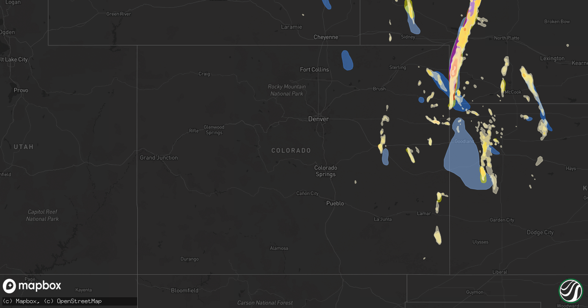
Hail Map in Colorado on July 19, 2024
Get this storm
July 19 map
$229
one time, instant access
Download today. No call, no setup
Keep the $229
Bought the map and want the full workflow? Apply the entire $229 to a subscription within 7 days. None of it is wasted.
Every map, not just this one
This buys you this map. Subscription and you get every map we run, in the markets you choose from a few cities to whole states to nationwide. Plus real-time alerts the moment a storm fires.
Contact data
Name, contact info, occupancy, even credit band for addresses in the footprint. You go from where it hit to who to call.
Become the source they trust
Unlimited branding weather history reports on demand. You already have the documented answer ready for the property owner, and you are the one who showed up with it.
Property data and RoofTrace estimates
Pull up any address you have got, its value and the exact code rules for that jurisdiction, straight from One Click Code. Then RoofTrace estimates the squares, pitch, and roof value, priced the way you price.
Storm reports in Colorado
Colorado
| Date | Description |
|---|---|
| 07/19/20246:55 PM CDT | A local report indicates 1.00 inch wind near 2 NNE Bristol |
| 07/19/20246:15 PM CDT | A local report indicates 1.00 inch wind near 5 S Sheridan Lake |
| 07/19/20242:02 PM CDT | Public report of 70 mph winds... Potentially higher... With heavy rain reducing visibility to near 0. |
| 07/19/20241:35 PM CDT | Delayed report of estimated 59 mph wind gust. |
| 07/19/20241:35 PM CDT | Delayed report of a pine tree being damaged. |
| 07/19/20241:30 PM CDT | Awn brophy reported a gust of 60 mph. |
| 07/19/20241:25 PM CDT | Corrects previous tstm wnd gst report from 9 n wauneta. Public report of 70 mph winds... Potentially higher... With heavy rain reducing visibility to near 0. |
| 07/19/20241:25 PM CDT | Delayed report of golf flags snapped at their bases and furniture flipped over. |
| 07/19/20241:15 PM CDT | Awn struckmeyer reported a 58 mph wind gust. |
| 07/19/20241:14 PM CDT | Small limbs down. Estimated gusts of around 60 mph along with heavy rain. |
| 07/18/202411:00 PM CDT | Heavy metal swing was moved roughly 10 feet. This swing is normally not moved unless winds are quite strong. Estimated time of report. |
| 07/18/202410:45 PM CDT | Pws-kcojoes3 on weather undergrounf. |
| 07/18/202410:15 PM CDT | Mesonet station dvi09409 yuma. |
| 07/18/202410:14 PM CDT | A local report indicates 80 MPH wind near 4 E Yuma |
| 07/18/202410:09 PM CDT | A local report indicates 60 MPH wind near 1 SSE Yuma |
| 07/18/202410:00 PM CDT | Social media reports with pictures of hail mostly around quarter in size... But up to golf ball. |
| 07/18/20248:30 PM CDT | Shingles and siding blown off house. Crop damage to corn. |
| 07/18/20247:51 PM CDT | A local report indicates 73 MPH wind near 6 S Hugo |
| 07/18/20247:45 PM CDT | Corrects previous non-tstm wnd gst report from hugo. Mesonet station ew0539 hugo. |
| 07/18/20247:42 PM CDT | A local report indicates 1.75 inch wind near 1 NE Limon |
| 07/18/20247:38 PM CDT | Corrects previous non-tstm wnd gst report from 8 ssw grover. Mesonet station cw5040 briggsdale. |
All States Impacted by Hail Map on July 19, 2024
Cities Impacted by Hail Map on July 19, 2024
- Cheyenne, WY
- Lagrange, WY
- Meriden, WY
- Albin, WY
- Highmore, SD
- Onida, SD
- Lebanon, SD
- Agar, SD
- Holabird, SD
- Pierre, SD
- Harrold, SD
- Fort Thompson, SD
- Wessington Springs, SD
- Chamberlain, SD
- Gann Valley, SD
- White Lake, SD
- Blunt, SD
- Utica, SD
- Yankton, SD
- Mission Hill, SD
- Randolph, NE
- Crofton, NE
- Burwell, NE
- Hartington, NE
- Menno, SD
- Wausa, NE
- Fordyce, NE
- Coleridge, NE
- Hayes, SD
- Chambers, NE
- Ozark, AL
- Sutherland, NE
- Laurel, NE
- Ewing, NE
- Inman, NE
- Creighton, NE
- Haxtun, CO
- Amelia, NE
- Plainview, NE
- Osmond, NE
- Holyoke, CO
- Leesburg, GA
- Bartlett, NE
- Buffalo, WY
- Wray, CO
- Midway, AL
- Cordele, GA
- Yuma, CO
- Haigler, NE
- Register, GA
- Metter, GA
- Live Oak, FL
- Madison, FL
- Lee, FL
- Vienna, GA
- Wanblee, SD
- Long Valley, SD
- Jennings, FL
- Parks, NE
- Primrose, NE
- Saint Francis, KS
- Benkelman, NE
- Bird City, KS
- Lake Park, GA
- Moorefield, NE
- Stockville, NE
- Cedar Rapids, NE
- Pavillion, WY
- Curtis, NE
- Labelle, FL
- Immokalee, FL
- Stockton, GA
- Eustis, NE
- Bartley, NE
- Cambridge, NE
- Vona, CO
- Lavonia, GA
- Hartwell, GA
- Lakeland, GA
- Naylor, GA
- Valdosta, GA
- Yoder, CO
- Fort Myers, FL
- Atwood, KS
- Ridgeland, SC
- Trenton, NE
- Du Pont, GA
- Colby, KS
- McDonald, KS
- Ocala, FL
- Culbertson, NE
- Micanopy, FL
- Jacksonville, FL
- Wilsonville, NE
- Amarillo, TX
- Hot Springs, SD
- Seibert, CO
- Flagler, CO
- Prairie City, SD
- Hardeeville, SC
- Okatie, SC
- Levant, KS
- Indianola, NE
- Brewster, KS
- Bethune, CO
- Gainesville, FL
- Riverton, WY
- Edgemont, SD
- Lebanon, NE
- Monument, KS
- Bosler, WY
- Newcastle, WY
- Richmond Hill, GA
- Callahan, FL
- Green Cove Springs, FL
- Bluffton, SC
- Stratton, CO
- Norton, KS
- Winona, KS
- Kit Carson, CO
- Oelrichs, SD
- Kilgore, NE
- Oberlin, KS
- Selden, KS
- Starke, FL
- Keystone Heights, FL
- Masterson, TX
- Midway, GA
- Riceboro, GA
- Channing, TX
- Mud Butte, SD
- Cody, NE
- Oakley, KS
- Lenora, KS
- Norcatur, KS
- Jennings, KS
- Valentine, NE
- Whitney, NE
- Crawford, NE
- Smithwick, SD
- Oral, SD
- Minter, AL
- Antelope, MT
- Middleburg, FL
- Vega, TX
- Union Center, SD
- Palatka, FL
- Wildorado, TX
- Otter, MT
- Hill City, KS
- Whitman, NE
- Newell, SD
- Sheridan Lake, CO
- Morland, KS
- Laramie, WY
- Sturgis, SD
- Pinewood, SC
- Manning, SC
- Marsland, NE
- Ellsworth, NE
- Santa Fe, NM
- East Palatka, FL
- Douglas, WY
- Sumter, SC
- Robstown, TX
- Wellfleet, NE
- Penokee, KS
- Mullen, NE
- New Underwood, SD
- Groveland, FL
- Hemingford, NE
- Scott City, KS
- Hereford, TX
- Roscoe, SD
- Hastings, FL
- Buffalo Gap, SD
- Maywood, NE
- Akron, CO
- Hayes Center, NE
- Ellsworth Afb, SD
- Box Elder, SD
- Rapid City, SD
- Leoti, KS
- Bunnell, FL
- Leesburg, FL
- Howey In The Hills, FL
- Lamy, NM
- Arthur, NE
- Marienthal, KS
- Eustis, FL
- Tryon, NE
- Wood River, NE
- Holly, CO
- Woodrow, CO
- Lindon, CO
- Juniata, NE
- Quinter, KS
- Eads, CO
- La Junta, CO
- Cheraw, CO
- Rocky Ford, CO
- Las Animas, CO
- Tribune, KS
- Dighton, KS
- Hermosa, SD
- Caputa, SD
- Kenesaw, NE
- Okahumpka, FL
- Yalaha, FL
- Farson, WY
- Pingree, ID
- Garden Valley, ID
- Bellvue, CO
- Arco, ID
- Milliken, CO
- Soda Springs, ID
- Rawlins, WY
- Cokeville, WY
- Green River, WY
- Burlington, CO
- Deer Trail, CO
- Hudson, CO
- Wamsutter, WY
- Arriba, CO
- Roggen, CO
- Midvale, ID
- Arapahoe, CO
- Johnstown, CO
- Weskan, KS
- Sun Valley, ID
- Firth, ID
- Huntington, OR
- Red Feather Lakes, CO
- Loveland, CO
- Drake, CO
- Fort Morgan, CO
- Smoot, WY
- Byers, CO
- Berthoud, CO
- Big Piney, WY
- Lowman, ID
- Wallace, KS
- Fort Lupton, CO
- Platteville, CO
- Ketchum, ID
- Cascade, ID
- Walden, CO
- Rock Springs, WY
- Sharon Springs, KS
- Keenesburg, CO
- Cope, CO
- Stanley, ID
- Encampment, WY
- La Grande, OR
- Wiggins, CO
- La Salle, CO
- Council, ID
- Anton, CO
- Mccall, ID
- Greeley, CO
- Saratoga, WY
- Kersey, CO
- Pilot Rock, OR
- Boulder, WY
- Shelley, ID
- Windsor, CO
- Fort Collins, CO
- Donnelly, ID
- Mackay, ID
- Grover, WY
- Union, OR
- Thayne, WY
- Moore, ID
- Oxbow, OR
- Freedom, WY
- Imnaha, OR
- Olympia, WA
- Helix, OR
- Prosser, WA
- Harrah, WA
- Ashford, WA
- Livermore, CO
- Timnath, CO
- Eatonville, WA
- Mabton, WA
- Elgin, OR
- Rainier, WA
- Alpine, WY
- Randle, WA
- Iona, ID
- Daniel, WY
- Enterprise, OR
- White Swan, WA
- Toppenish, WA
- Mccleary, WA
- Kennewick, WA
- Roberts, ID
- Idaho Falls, ID
- Joseph, OR
- Packwood, WA
- Mineral, WA
- Pinedale, WY
- New Meadows, ID
- Laporte, CO
- Lostine, OR
- Lander, WY
- Challis, ID
- Yelm, WA
- Beeler, KS
- Utica, KS
- Stanley, NM
- Angora, NE
- Genoa, CO
- Limon, CO
- Bayard, NE
- Roseland, NE
- Keystone, NE
- Lemoyne, NE
- Ogallala, NE
- Hill City, SD
- Mccammon, ID
- Cora, WY
- Declo, ID
- Twin Falls, ID
- Custer, SD
- Bondurant, WY
- Pocatello, ID
- Orovada, NV
- Bruneau, ID
- Kaycee, WY
- Gillette, WY
- Wright, WY
- Lysite, WY
- Kinnear, WY
- Upton, WY
- Rogerson, ID
- Inkom, ID
- American Falls, ID
- Burley, ID
- Murtaugh, ID
- Oakley, ID
- Malta, ID
- Rockland, ID
- Ten Sleep, WY
- Shoshoni, WY
- Owyhee, NV
- Bancroft, ID
- Mountain City, NV
- Gerlach, NV
- Bridgeport, NE
- Miller, NE
- Paxton, NE
- Pine Ridge, SD
- Holstein, NE
- Brule, NE
- Minden, NE
- Upland, NE
- Broadwater, NE
- Hugo, CO
- Bladen, NE
- Granada, CO
- Dalton, NE
- Grant, NE
- Harrisburg, NE
- Potter, NE
- Campbell, NE
- Friona, TX
- Venango, NE
- Palisade, NE
- Chugwater, WY
- Karval, CO
- Broadview, NM
- Walsh, CO
- Red Cloud, NE
- Inavale, NE
- Wolbach, NE
- Riverton, NE
- Franklin, NE
- Two Buttes, CO
- Orleans, NE
- Long Island, KS
- Alma, NE
- Republican City, NE
- Bloomington, NE
- Almena, KS
- Naponee, NE
- Imperial, NE
- Champion, NE
- Gurley, NE
- Sidney, NE
- Lodgepole, NE
- Grover, CO
- Briggsdale, CO
- Weldona, CO
- Snyder, CO
- Dix, NE
- Saint Paul, NE
- Texico, NM
- Merriman, NE
- Smith Center, KS
- Comstock, NE
- Clovis, NM
- Sumner, NE
- Taylor, NE
- Wauneta, NE
- Palmer, NE
- Norris, SD
- Greeley, NE
- Gaylord, KS
- San Jon, NM
- Vernon, CO
- Idalia, CO
- Kirk, CO
- Otis, CO
- Goodwell, OK
- Portis, KS
- Eckley, CO
- Osborne, KS
- Gem, KS
- Springfield, CO
- Downs, KS
- Edson, KS
- Goodland, KS
- Kanorado, KS
- Guymon, OK
- Texhoma, OK
- Stratford, TX
- Gruver, TX
- Sunray, TX
- Dumas, TX
- Cactus, TX
- Morse, TX
- Stinnett, TX
- Big Springs, NE
- Madrid, NE
- Elsie, NE
- Collyer, KS
- Wakeeney, KS
- Amherst, CO


