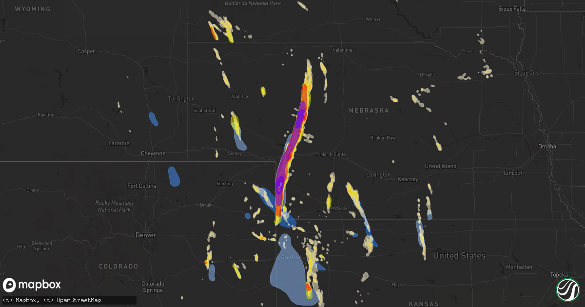
Hail Map on July 19, 2024
Get this storm
July 19 map
$229
one time, instant access
Download today. No call, no setup
Keep the $229
Bought the map and want the full workflow? Apply the entire $229 to a subscription within 7 days. None of it is wasted.
Every map, not just this one
This buys you this map. Subscription and you get every map we run, in the markets you choose from a few cities to whole states to nationwide. Plus real-time alerts the moment a storm fires.
Contact data
Name, contact info, occupancy, even credit band for addresses in the footprint. You go from where it hit to who to call.
Become the source they trust
Unlimited branding weather history reports on demand. You already have the documented answer ready for the property owner, and you are the one who showed up with it.
Property data and RoofTrace estimates
Pull up any address you have got, its value and the exact code rules for that jurisdiction, straight from One Click Code. Then RoofTrace estimates the squares, pitch, and roof value, priced the way you price.
States Impacted by Hail Map on July 19, 2024
Storm reports
Oklahoma
| Date | Description |
|---|---|
| 07/18/202411:10 PM CDT | A local report indicates 60 MPH wind near 2 ENE Goodwell |
| 07/18/202410:15 PM CDT | A local report indicates 67 MPH wind near 11 NE Eva |
| 07/18/202410:05 PM CDT | A local report indicates 59 MPH wind near 11 NE Eva |
Idaho
| Date | Description |
|---|---|
| 07/19/20246:52 PM CDT | Bingham county 911 reports 5 power poles snapped off along n 1400 w in the area of us-26. Time estimated based on radar. |
| 07/19/20246:52 PM CDT | Updated...bingham county 911 reports 5 power poles snapped off along n 1400 w in the area of us-26 also causing a fire. Time estimated based on radar. |
| 07/18/20248:15 PM CDT | Mesonet station fthi. |
| 07/18/20247:55 PM CDT | 2 trees reported down on river ranch rd via social media. Time estimated based on radar. |
| 07/18/20247:50 PM CDT | Large section of tree down knocking down a wood stockade fence and damaging a swing set along pendlebury ln. Power out. Report and photos via social media. Time estimat |
| 07/18/20247:50 PM CDT | Bingham county 911 reports multiple calls for trees and wires down concentrated across southern parts of the city of blackfoot. Time estimated based on radar. |
| 07/18/20247:49 PM CDT | Large tree limbs down along s broadway st in the area of the rv park. Time estimated based on radar. |
| 07/18/20247:49 PM CDT | Large tree uprooted and down on a truck near the intersection of dennis st and opal st. Extent of any vehicle damage unknown. Report and photos obtained from social med |
| 07/18/20247:49 PM CDT | Large section of tree down at blackfoot high school. Time estimated based on radar and surrounding reports. |
| 07/18/20247:48 PM CDT | Window broken by flying tree limb. Power out. Time estimated based on radar and surrounding reports. |
| 07/18/20247:47 PM CDT | Idaho power reports approximately 7...700 customers without power from gibson... To blackfoot... To wapello. |
| 07/18/20247:46 PM CDT | Large pine tree uprooted on the corner of w center st and lansing st. Time estimated based on radar. |
| 07/18/20247:43 PM CDT | Large tree limbs down on the north side of groveland. Time estimated based on radar. |
| 07/18/20247:22 PM CDT | Large pine tree uprooted and down on a fence. Report and photo received from the public via the nws pocatello facebook page. Time estimated based on radar and surroundi |
| 07/18/20247:20 PM CDT | Numerous shingles blown off residential roof along id-39 in rockford. Time estimated based on radar. |
| 07/18/20247:10 PM CDT | Large tree down near the intersection of w 200 n and n 1400 w. Time estimated based on radar. |
North Carolina
| Date | Description |
|---|---|
| 07/18/20247:33 PM CDT | Tree down in the 9000 block of pine street blocking one lane of traffic. |
New Mexico
| Date | Description |
|---|---|
| 07/18/20249:14 PM CDT | A local report indicates 58 MPH wind near 7 E Tucumcari |
Wyoming
| Date | Description |
|---|---|
| 07/18/20247:14 PM CDT | Wydot sensor |
Kansas
| Date | Description |
|---|---|
| 07/19/20246:12 PM CDT | Most of the hail was dime size... With some quarter size hail mixed in; lasted 5-10 minutes. Very windy but could not estimate the wind speed. |
| 07/19/20245:47 PM CDT | Public report of quarter sized hail with a few golf ball sized stones mixed in. |
| 07/19/20245:05 PM CDT | Estimate |
| 07/19/20245:05 PM CDT | Estimated 60 mph winds from heavy patio furniture being blown around and tree branches being bent horizontal. |
| 07/19/20245:00 PM CDT | Report of 50-60 mph winds estimated. |
| 07/19/20244:45 PM CDT | Delayed report of estimated 60 mph winds at the landfill. |
| 07/19/20244:42 PM CDT | Mesonet station nrrk1 norton 4sw. |
| 07/19/20244:31 PM CDT | Mesonet station nrrk1 norton 4sw. |
| 07/19/20244:25 PM CDT | A local report indicates 59 MPH wind near 9 N Page City |
| 07/18/202411:33 PM CDT | Kansas mesonet site russell springs 3 sw. |
| 07/18/202411:33 PM CDT | Section_17_ |
| 07/18/202411:31 PM CDT | Site up840 reported 69 mph wind gust. |
| 07/18/202411:31 PM CDT | Site up840 reported 69 |
| 07/18/202411:26 PM CDT | Site up840 reported a 62 mph wind gust associated with storm outflow. |
| 07/18/202411:22 PM CDT | Section_17_ |
| 07/18/202411:00 PM CDT | Delayed report via twitter estimated 60+ mph winds along with small hail and very heavy rain. Video was sent in from same person that said the winds lasted for nearly 3 |
| 07/18/202411:00 PM CDT | Asos station kgld goodland. |
| 07/18/202411:00 PM CDT | Site k5ed7 reported a 62 mph wind gust. |
| 07/18/202410:54 PM CDT | Kansas mesonet site. |
| 07/18/202410:38 PM CDT | A local report indicates 58 MPH wind near 1 NNW Osborne |
| 07/18/202410:25 PM CDT | Public reported quarter sized hail in the city of colby at 925 pm mdt / 1025 pm cdt. |
| 07/18/20249:35 PM CDT | A local report indicates 62 MPH wind near Smith Center Airport |
| 07/18/20249:35 PM CDT | Reports vis social media of tree damage in smith center... Heavy rain causing street flooding and power out to about 200f the town. |
South Carolina
| Date | Description |
|---|---|
| 07/19/20246:19 PM CDT | Sumter county dispatch reports trees down on bethel church rd near the intersection of lloyd dr. Time estimated from radar. |
| 07/18/20247:19 PM CDT | Multiple trees blown down along cottonflower rd. Time estimated by radar. |
South Dakota
| Date | Description |
|---|---|
| 07/19/20246:25 PM CDT | A local report indicates 70 MPH wind near 1 N Hereford |
| 07/19/20246:25 PM CDT | Lots of crop damage around the hereford area. 4 to 5 inch branches broken off trees. Estimated 70 mph wind gusts and nickle size hail. |
| 07/19/20246:06 PM CDT | A local report indicates 1.25 inch wind near 6 NNW Hereford |
| 07/19/20246:06 PM CDT | A local report indicates 90 MPH wind near 6 NNW Hereford |
| 07/19/20246:06 PM CDT | Broken windows in house and vehicles... And patio destroyed. Estimated 90 mph winds and half dollar size hail. |
| 07/19/20245:50 PM CDT | A local report indicates 70 MPH wind near 6 WSW Fairpoint |
| 07/19/20245:00 PM CDT | A local report indicates 62 MPH wind near 1 ENE Mud Butte |
Florida
| Date | Description |
|---|---|
| 07/19/20246:10 PM CDT | Putnam county emergency management reported wind damage just across the county border in st. Johns county just to the west of hastings... Along old hastings road. A rec |
Colorado
| Date | Description |
|---|---|
| 07/19/20246:55 PM CDT | A local report indicates 1.00 inch wind near 2 NNE Bristol |
| 07/19/20246:15 PM CDT | A local report indicates 1.00 inch wind near 5 S Sheridan Lake |
| 07/19/20242:02 PM CDT | Public report of 70 mph winds... Potentially higher... With heavy rain reducing visibility to near 0. |
| 07/19/20241:35 PM CDT | Delayed report of a pine tree being damaged. |
| 07/19/20241:35 PM CDT | Delayed report of estimated 59 mph wind gust. |
| 07/19/20241:30 PM CDT | Awn brophy reported a gust of 60 mph. |
| 07/19/20241:25 PM CDT | Delayed report of golf flags snapped at their bases and furniture flipped over. |
| 07/19/20241:25 PM CDT | Corrects previous tstm wnd gst report from 9 n wauneta. Public report of 70 mph winds... Potentially higher... With heavy rain reducing visibility to near 0. |
| 07/19/20241:15 PM CDT | Awn struckmeyer reported a 58 mph wind gust. |
| 07/19/20241:14 PM CDT | Small limbs down. Estimated gusts of around 60 mph along with heavy rain. |
| 07/18/202411:00 PM CDT | Heavy metal swing was moved roughly 10 feet. This swing is normally not moved unless winds are quite strong. Estimated time of report. |
| 07/18/202410:45 PM CDT | Pws-kcojoes3 on weather undergrounf. |
| 07/18/202410:15 PM CDT | Mesonet station dvi09409 yuma. |
| 07/18/202410:14 PM CDT | A local report indicates 80 MPH wind near 4 E Yuma |
| 07/18/202410:09 PM CDT | A local report indicates 60 MPH wind near 1 SSE Yuma |
| 07/18/202410:00 PM CDT | Social media reports with pictures of hail mostly around quarter in size... But up to golf ball. |
| 07/18/20248:30 PM CDT | Shingles and siding blown off house. Crop damage to corn. |
| 07/18/20247:51 PM CDT | A local report indicates 73 MPH wind near 6 S Hugo |
| 07/18/20247:45 PM CDT | Corrects previous non-tstm wnd gst report from hugo. Mesonet station ew0539 hugo. |
| 07/18/20247:42 PM CDT | A local report indicates 1.75 inch wind near 1 NE Limon |
| 07/18/20247:38 PM CDT | Corrects previous non-tstm wnd gst report from 8 ssw grover. Mesonet station cw5040 briggsdale. |
Texas
| Date | Description |
|---|---|
| 07/19/20243:49 PM CDT | A local report indicates 1.00 inch wind near Valley de Oro |
| 07/18/202411:40 PM CDT | A local report indicates 63 MPH wind near 9 NNE Sunray |
| 07/18/20247:45 PM CDT | Corrects previous tstm wnd gst report from 11 wsw bootleg. Peak weak gust observed at the mesonet so far. |
| 07/18/20247:43 PM CDT | First severe wind gust observed at the mesonet. |
| 07/18/20247:43 PM CDT | Corrects prev |
| 07/18/20247:43 PM CDT | Corrects previous tstm wnd gst report from 11 wsw bootleg. First severe wind gust observed at the mesonet. |
Nebraska
| Date | Description |
|---|---|
| 07/19/20246:50 PM CDT | A local report indicates 1.50 inch wind near 13 E Arthur |
| 07/19/20246:49 PM CDT | Public posted a picture on social media holding a hail stone between a baseball and a softball in size. |
| 07/19/20246:36 PM CDT | Public report on social media of hail stones next to a ruler. |
| 07/19/20246:32 PM CDT | Public report with a picture on social media attesting to hail as large as 4 inches. |
| 07/19/20246:28 PM CDT | Report via social media. Time estimated by radar. |
| 07/19/20246:26 PM CDT | Photos received via social media. Time estimated by radar. |
| 07/19/20246:16 PM CDT | Social media report estimated wind gusts of 70 mph and pea to nickel size hail covering the ground. |
| 07/19/20246:00 PM CDT | Ne-meso whtn1. |
| 07/19/20245:38 PM CDT | A local report indicates 1.75 inch wind near 18 NE Whitman |
| 07/19/20243:58 PM CDT | A local report indicates 59 MPH wind near 3 NNW Wilsonville |
| 07/19/20243:35 PM CDT | Measured at the cambridge airport. |
| 07/19/20243:20 PM CDT | Pws knecambr3. |
| 07/19/20242:15 PM CDT | Trained spotter reports 50-60 mph gusts with plumes of dust reducing visibility down to less than 1/4 mile. |
| 07/18/20248:44 PM CDT | Delayed report. Time estimated by radar. |
| 07/18/20248:44 PM CDT | Delayed report. Emergency manager reports a pivot system was flipped at this location due to winds of at least 70 miles per hour. Time estimated by radar. |
| 07/18/20248:41 PM CDT | Time estimated by radar. |
| 07/18/20248:26 PM CDT | A local report indicates 2.50 inch wind near 4 SE Venango |
| 07/18/20248:15 PM CDT | Emergency manager reports wind gusts of 65 to 70 mph and heavy rains. |
| 07/18/20248:11 PM CDT | A local report indicates 59 MPH wind near 5 NNE Inavale |
| 07/18/20248:11 PM CDT | A local report indicates 59 MPH wind near 2 W Red Cloud |
| 07/18/20247:43 PM CDT | A local report indicates 2.50 inch wind near 1 E Ogallala |
| 07/18/20247:41 PM CDT | Report via social media. Time estimated by radar. |
| 07/18/20247:40 PM CDT | Broken windsheild occurred on highway 30. |
| 07/18/20247:39 PM CDT | Public picture on social media of hail stones smaller than an orange but at least twice the size of a quarter. Hail fell at the ogallala fairgrounds. |
| 07/18/20247:38 PM CDT | Golf ball to tennis ball sized hail reported on the west side of ogallala. |
| 07/18/20247:36 PM CDT | Upr site gusted 75 mph along us highway 26. |
| 07/18/20247:24 PM CDT | *** 1 inj *** from hail stones. |
| 07/18/20247:24 PM CDT | Pws knelemoy4. |
| 07/18/20247:22 PM CDT | Hail ranged from pea to quarter size; last roughly 3 minutes. |
| 07/18/20247:03 PM CDT | A local report indicates 1.75 inch wind near 10 SE Arthur |
Cities Impacted by Hail Map on July 19, 2024
- Cheyenne, WY
- Lagrange, WY
- Meriden, WY
- Albin, WY
- Highmore, SD
- Onida, SD
- Lebanon, SD
- Agar, SD
- Holabird, SD
- Pierre, SD
- Harrold, SD
- Fort Thompson, SD
- Wessington Springs, SD
- Chamberlain, SD
- Gann Valley, SD
- White Lake, SD
- Blunt, SD
- Utica, SD
- Yankton, SD
- Mission Hill, SD
- Randolph, NE
- Crofton, NE
- Burwell, NE
- Hartington, NE
- Menno, SD
- Wausa, NE
- Fordyce, NE
- Coleridge, NE
- Hayes, SD
- Chambers, NE
- Ozark, AL
- Sutherland, NE
- Laurel, NE
- Ewing, NE
- Inman, NE
- Creighton, NE
- Haxtun, CO
- Amelia, NE
- Plainview, NE
- Osmond, NE
- Holyoke, CO
- Leesburg, GA
- Bartlett, NE
- Buffalo, WY
- Wray, CO
- Midway, AL
- Cordele, GA
- Yuma, CO
- Haigler, NE
- Register, GA
- Metter, GA
- Live Oak, FL
- Madison, FL
- Lee, FL
- Vienna, GA
- Wanblee, SD
- Long Valley, SD
- Jennings, FL
- Parks, NE
- Primrose, NE
- Saint Francis, KS
- Benkelman, NE
- Bird City, KS
- Lake Park, GA
- Moorefield, NE
- Stockville, NE
- Cedar Rapids, NE
- Pavillion, WY
- Curtis, NE
- Labelle, FL
- Immokalee, FL
- Stockton, GA
- Eustis, NE
- Bartley, NE
- Cambridge, NE
- Vona, CO
- Lavonia, GA
- Hartwell, GA
- Lakeland, GA
- Naylor, GA
- Valdosta, GA
- Yoder, CO
- Fort Myers, FL
- Atwood, KS
- Ridgeland, SC
- Trenton, NE
- Du Pont, GA
- Colby, KS
- McDonald, KS
- Ocala, FL
- Culbertson, NE
- Micanopy, FL
- Jacksonville, FL
- Wilsonville, NE
- Amarillo, TX
- Hot Springs, SD
- Seibert, CO
- Flagler, CO
- Prairie City, SD
- Hardeeville, SC
- Okatie, SC
- Levant, KS
- Indianola, NE
- Brewster, KS
- Bethune, CO
- Gainesville, FL
- Riverton, WY
- Edgemont, SD
- Lebanon, NE
- Monument, KS
- Bosler, WY
- Newcastle, WY
- Richmond Hill, GA
- Callahan, FL
- Green Cove Springs, FL
- Bluffton, SC
- Stratton, CO
- Norton, KS
- Winona, KS
- Kit Carson, CO
- Oelrichs, SD
- Kilgore, NE
- Oberlin, KS
- Selden, KS
- Starke, FL
- Keystone Heights, FL
- Masterson, TX
- Midway, GA
- Riceboro, GA
- Channing, TX
- Mud Butte, SD
- Cody, NE
- Oakley, KS
- Lenora, KS
- Norcatur, KS
- Jennings, KS
- Valentine, NE
- Whitney, NE
- Crawford, NE
- Smithwick, SD
- Oral, SD
- Minter, AL
- Antelope, MT
- Middleburg, FL
- Vega, TX
- Union Center, SD
- Palatka, FL
- Wildorado, TX
- Otter, MT
- Hill City, KS
- Whitman, NE
- Newell, SD
- Sheridan Lake, CO
- Morland, KS
- Laramie, WY
- Sturgis, SD
- Pinewood, SC
- Manning, SC
- Marsland, NE
- Ellsworth, NE
- Santa Fe, NM
- East Palatka, FL
- Douglas, WY
- Sumter, SC
- Robstown, TX
- Wellfleet, NE
- Penokee, KS
- Mullen, NE
- New Underwood, SD
- Groveland, FL
- Hemingford, NE
- Scott City, KS
- Hereford, TX
- Roscoe, SD
- Hastings, FL
- Buffalo Gap, SD
- Maywood, NE
- Akron, CO
- Hayes Center, NE
- Ellsworth Afb, SD
- Box Elder, SD
- Rapid City, SD
- Leoti, KS
- Bunnell, FL
- Leesburg, FL
- Howey In The Hills, FL
- Lamy, NM
- Arthur, NE
- Marienthal, KS
- Eustis, FL
- Tryon, NE
- Wood River, NE
- Holly, CO
- Woodrow, CO
- Lindon, CO
- Juniata, NE
- Quinter, KS
- Eads, CO
- La Junta, CO
- Cheraw, CO
- Rocky Ford, CO
- Las Animas, CO
- Tribune, KS
- Dighton, KS
- Hermosa, SD
- Caputa, SD
- Kenesaw, NE
- Okahumpka, FL
- Yalaha, FL
- Farson, WY
- Pingree, ID
- Garden Valley, ID
- Bellvue, CO
- Arco, ID
- Milliken, CO
- Soda Springs, ID
- Rawlins, WY
- Cokeville, WY
- Green River, WY
- Burlington, CO
- Deer Trail, CO
- Hudson, CO
- Wamsutter, WY
- Arriba, CO
- Roggen, CO
- Midvale, ID
- Arapahoe, CO
- Johnstown, CO
- Weskan, KS
- Sun Valley, ID
- Firth, ID
- Huntington, OR
- Red Feather Lakes, CO
- Loveland, CO
- Drake, CO
- Fort Morgan, CO
- Smoot, WY
- Byers, CO
- Berthoud, CO
- Big Piney, WY
- Lowman, ID
- Wallace, KS
- Fort Lupton, CO
- Platteville, CO
- Ketchum, ID
- Cascade, ID
- Walden, CO
- Rock Springs, WY
- Sharon Springs, KS
- Keenesburg, CO
- Cope, CO
- Stanley, ID
- Encampment, WY
- La Grande, OR
- Wiggins, CO
- La Salle, CO
- Council, ID
- Anton, CO
- Mccall, ID
- Greeley, CO
- Saratoga, WY
- Kersey, CO
- Pilot Rock, OR
- Boulder, WY
- Shelley, ID
- Windsor, CO
- Fort Collins, CO
- Donnelly, ID
- Mackay, ID
- Grover, WY
- Union, OR
- Thayne, WY
- Moore, ID
- Oxbow, OR
- Freedom, WY
- Imnaha, OR
- Olympia, WA
- Helix, OR
- Prosser, WA
- Harrah, WA
- Ashford, WA
- Livermore, CO
- Timnath, CO
- Eatonville, WA
- Mabton, WA
- Elgin, OR
- Rainier, WA
- Alpine, WY
- Randle, WA
- Iona, ID
- Daniel, WY
- Enterprise, OR
- White Swan, WA
- Toppenish, WA
- Mccleary, WA
- Kennewick, WA
- Roberts, ID
- Idaho Falls, ID
- Joseph, OR
- Packwood, WA
- Mineral, WA
- Pinedale, WY
- New Meadows, ID
- Laporte, CO
- Lostine, OR
- Lander, WY
- Challis, ID
- Yelm, WA
- Beeler, KS
- Utica, KS
- Stanley, NM
- Angora, NE
- Genoa, CO
- Limon, CO
- Bayard, NE
- Roseland, NE
- Keystone, NE
- Lemoyne, NE
- Ogallala, NE
- Hill City, SD
- Mccammon, ID
- Cora, WY
- Declo, ID
- Twin Falls, ID
- Custer, SD
- Bondurant, WY
- Pocatello, ID
- Orovada, NV
- Bruneau, ID
- Kaycee, WY
- Gillette, WY
- Wright, WY
- Lysite, WY
- Kinnear, WY
- Upton, WY
- Rogerson, ID
- Inkom, ID
- American Falls, ID
- Burley, ID
- Murtaugh, ID
- Oakley, ID
- Malta, ID
- Rockland, ID
- Ten Sleep, WY
- Shoshoni, WY
- Owyhee, NV
- Bancroft, ID
- Mountain City, NV
- Gerlach, NV
- Bridgeport, NE
- Miller, NE
- Paxton, NE
- Pine Ridge, SD
- Holstein, NE
- Brule, NE
- Minden, NE
- Upland, NE
- Broadwater, NE
- Hugo, CO
- Bladen, NE
- Granada, CO
- Dalton, NE
- Grant, NE
- Harrisburg, NE
- Potter, NE
- Campbell, NE
- Friona, TX
- Venango, NE
- Palisade, NE
- Chugwater, WY
- Karval, CO
- Broadview, NM
- Walsh, CO
- Red Cloud, NE
- Inavale, NE
- Wolbach, NE
- Riverton, NE
- Franklin, NE
- Two Buttes, CO
- Orleans, NE
- Long Island, KS
- Alma, NE
- Republican City, NE
- Bloomington, NE
- Almena, KS
- Naponee, NE
- Imperial, NE
- Champion, NE
- Gurley, NE
- Sidney, NE
- Lodgepole, NE
- Grover, CO
- Briggsdale, CO
- Weldona, CO
- Snyder, CO
- Dix, NE
- Saint Paul, NE
- Texico, NM
- Merriman, NE
- Smith Center, KS
- Comstock, NE
- Clovis, NM
- Sumner, NE
- Taylor, NE
- Wauneta, NE
- Palmer, NE
- Norris, SD
- Greeley, NE
- Gaylord, KS
- San Jon, NM
- Vernon, CO
- Idalia, CO
- Kirk, CO
- Otis, CO
- Goodwell, OK
- Portis, KS
- Eckley, CO
- Osborne, KS
- Gem, KS
- Springfield, CO
- Downs, KS
- Edson, KS
- Goodland, KS
- Kanorado, KS
- Guymon, OK
- Texhoma, OK
- Stratford, TX
- Gruver, TX
- Sunray, TX
- Dumas, TX
- Cactus, TX
- Morse, TX
- Stinnett, TX
- Big Springs, NE
- Madrid, NE
- Elsie, NE
- Collyer, KS
- Wakeeney, KS
- Amherst, CO