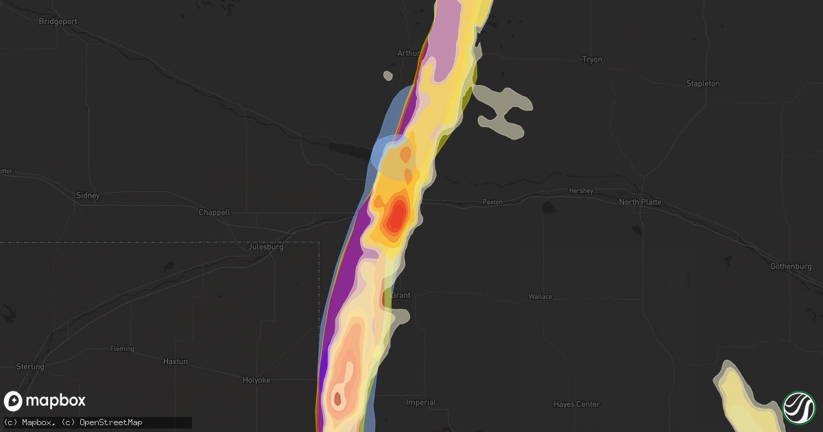
Hail Map in Ogallala, NE on July 19, 2024
Get this storm
July 19 map
$229
one time, instant access
Download today. No call, no setup
Keep the $229
Bought the map and want the full workflow? Apply the entire $229 to a subscription within 7 days. None of it is wasted.
Every map, not just this one
This buys you this map. Subscription and you get every map we run, in the markets you choose from a few cities to whole states to nationwide. Plus real-time alerts the moment a storm fires.
Contact data
Name, contact info, occupancy, even credit band for addresses in the footprint. You go from where it hit to who to call.
Become the source they trust
Unlimited branding weather history reports on demand. You already have the documented answer ready for the property owner, and you are the one who showed up with it.
Property data and RoofTrace estimates
Pull up any address you have got, its value and the exact code rules for that jurisdiction, straight from One Click Code. Then RoofTrace estimates the squares, pitch, and roof value, priced the way you price.
Storm reports in Ogallala, NE
Ogallala, NE
| Date | Description |
|---|---|
| 07/18/20247:43 PM CDT | A local report indicates 2.50 inch wind near 1 E Ogallala |
| 07/18/20247:41 PM CDT | Report via social media. Time estimated by radar. |
| 07/18/20247:40 PM CDT | Broken windsheild occurred on highway 30. |
| 07/18/20247:39 PM CDT | Public picture on social media of hail stones smaller than an orange but at least twice the size of a quarter. Hail fell at the ogallala fairgrounds. |
| 07/18/20247:38 PM CDT | Golf ball to tennis ball sized hail reported on the west side of ogallala. |
All States Impacted by Hail Map on July 19, 2024
All Cities Impacted by Hail Map on July 19, 2024
- Cheyenne, WY
- Lagrange, WY
- Meriden, WY
- Albin, WY
- Highmore, SD
- Onida, SD
- Lebanon, SD
- Agar, SD
- Holabird, SD
- Pierre, SD
- Harrold, SD
- Fort Thompson, SD
- Wessington Springs, SD
- Chamberlain, SD
- Gann Valley, SD
- White Lake, SD
- Blunt, SD
- Utica, SD
- Yankton, SD
- Mission Hill, SD
- Randolph, NE
- Crofton, NE
- Burwell, NE
- Hartington, NE
- Menno, SD
- Wausa, NE
- Fordyce, NE
- Coleridge, NE
- Hayes, SD
- Chambers, NE
- Ozark, AL
- Sutherland, NE
- Laurel, NE
- Ewing, NE
- Inman, NE
- Creighton, NE
- Haxtun, CO
- Amelia, NE
- Plainview, NE
- Osmond, NE
- Holyoke, CO
- Leesburg, GA
- Bartlett, NE
- Buffalo, WY
- Wray, CO
- Midway, AL
- Cordele, GA
- Yuma, CO
- Haigler, NE
- Register, GA
- Metter, GA
- Live Oak, FL
- Madison, FL
- Lee, FL
- Vienna, GA
- Wanblee, SD
- Long Valley, SD
- Jennings, FL
- Parks, NE
- Primrose, NE
- Saint Francis, KS
- Benkelman, NE
- Bird City, KS
- Lake Park, GA
- Moorefield, NE
- Stockville, NE
- Cedar Rapids, NE
- Pavillion, WY
- Curtis, NE
- Labelle, FL
- Immokalee, FL
- Stockton, GA
- Eustis, NE
- Bartley, NE
- Cambridge, NE
- Vona, CO
- Lavonia, GA
- Hartwell, GA
- Lakeland, GA
- Naylor, GA
- Valdosta, GA
- Yoder, CO
- Fort Myers, FL
- Atwood, KS
- Ridgeland, SC
- Trenton, NE
- Du Pont, GA
- Colby, KS
- McDonald, KS
- Ocala, FL
- Culbertson, NE
- Micanopy, FL
- Jacksonville, FL
- Wilsonville, NE
- Amarillo, TX
- Hot Springs, SD
- Seibert, CO
- Flagler, CO
- Prairie City, SD
- Hardeeville, SC
- Okatie, SC
- Levant, KS
- Indianola, NE
- Brewster, KS
- Bethune, CO
- Gainesville, FL
- Riverton, WY
- Edgemont, SD
- Lebanon, NE
- Monument, KS
- Bosler, WY
- Newcastle, WY
- Richmond Hill, GA
- Callahan, FL
- Green Cove Springs, FL
- Bluffton, SC
- Stratton, CO
- Norton, KS
- Winona, KS
- Kit Carson, CO
- Oelrichs, SD
- Kilgore, NE
- Oberlin, KS
- Selden, KS
- Starke, FL
- Keystone Heights, FL
- Masterson, TX
- Midway, GA
- Riceboro, GA
- Channing, TX
- Mud Butte, SD
- Cody, NE
- Oakley, KS
- Lenora, KS
- Norcatur, KS
- Jennings, KS
- Valentine, NE
- Whitney, NE
- Crawford, NE
- Smithwick, SD
- Oral, SD
- Minter, AL
- Antelope, MT
- Middleburg, FL
- Vega, TX
- Union Center, SD
- Palatka, FL
- Wildorado, TX
- Otter, MT
- Hill City, KS
- Whitman, NE
- Newell, SD
- Sheridan Lake, CO
- Morland, KS
- Laramie, WY
- Sturgis, SD
- Pinewood, SC
- Manning, SC
- Marsland, NE
- Ellsworth, NE
- Santa Fe, NM
- East Palatka, FL
- Douglas, WY
- Sumter, SC
- Robstown, TX
- Wellfleet, NE
- Penokee, KS
- Mullen, NE
- New Underwood, SD
- Groveland, FL
- Hemingford, NE
- Scott City, KS
- Hereford, TX
- Roscoe, SD
- Hastings, FL
- Buffalo Gap, SD
- Maywood, NE
- Akron, CO
- Hayes Center, NE
- Ellsworth Afb, SD
- Box Elder, SD
- Rapid City, SD
- Leoti, KS
- Bunnell, FL
- Leesburg, FL
- Howey In The Hills, FL
- Lamy, NM
- Arthur, NE
- Marienthal, KS
- Eustis, FL
- Tryon, NE
- Wood River, NE
- Holly, CO
- Woodrow, CO
- Lindon, CO
- Juniata, NE
- Quinter, KS
- Eads, CO
- La Junta, CO
- Cheraw, CO
- Rocky Ford, CO
- Las Animas, CO
- Tribune, KS
- Dighton, KS
- Hermosa, SD
- Caputa, SD
- Kenesaw, NE
- Okahumpka, FL
- Yalaha, FL
- Farson, WY
- Pingree, ID
- Garden Valley, ID
- Bellvue, CO
- Arco, ID
- Milliken, CO
- Soda Springs, ID
- Rawlins, WY
- Cokeville, WY
- Green River, WY
- Burlington, CO
- Deer Trail, CO
- Hudson, CO
- Wamsutter, WY
- Arriba, CO
- Roggen, CO
- Midvale, ID
- Arapahoe, CO
- Johnstown, CO
- Weskan, KS
- Sun Valley, ID
- Firth, ID
- Huntington, OR
- Red Feather Lakes, CO
- Loveland, CO
- Drake, CO
- Fort Morgan, CO
- Smoot, WY
- Byers, CO
- Berthoud, CO
- Big Piney, WY
- Lowman, ID
- Wallace, KS
- Fort Lupton, CO
- Platteville, CO
- Ketchum, ID
- Cascade, ID
- Walden, CO
- Rock Springs, WY
- Sharon Springs, KS
- Keenesburg, CO
- Cope, CO
- Stanley, ID
- Encampment, WY
- La Grande, OR
- Wiggins, CO
- La Salle, CO
- Council, ID
- Anton, CO
- Mccall, ID
- Greeley, CO
- Saratoga, WY
- Kersey, CO
- Pilot Rock, OR
- Boulder, WY
- Shelley, ID
- Windsor, CO
- Fort Collins, CO
- Donnelly, ID
- Mackay, ID
- Grover, WY
- Union, OR
- Thayne, WY
- Moore, ID
- Oxbow, OR
- Freedom, WY
- Imnaha, OR
- Olympia, WA
- Helix, OR
- Prosser, WA
- Harrah, WA
- Ashford, WA
- Livermore, CO
- Timnath, CO
- Eatonville, WA
- Mabton, WA
- Elgin, OR
- Rainier, WA
- Alpine, WY
- Randle, WA
- Iona, ID
- Daniel, WY
- Enterprise, OR
- White Swan, WA
- Toppenish, WA
- Mccleary, WA
- Kennewick, WA
- Roberts, ID
- Idaho Falls, ID
- Joseph, OR
- Packwood, WA
- Mineral, WA
- Pinedale, WY
- New Meadows, ID
- Laporte, CO
- Lostine, OR
- Lander, WY
- Challis, ID
- Yelm, WA
- Beeler, KS
- Utica, KS
- Stanley, NM
- Angora, NE
- Genoa, CO
- Limon, CO
- Bayard, NE
- Roseland, NE
- Keystone, NE
- Lemoyne, NE
- Ogallala, NE
- Hill City, SD
- Mccammon, ID
- Cora, WY
- Declo, ID
- Twin Falls, ID
- Custer, SD
- Bondurant, WY
- Pocatello, ID
- Orovada, NV
- Bruneau, ID
- Kaycee, WY
- Gillette, WY
- Wright, WY
- Lysite, WY
- Kinnear, WY
- Upton, WY
- Rogerson, ID
- Inkom, ID
- American Falls, ID
- Burley, ID
- Murtaugh, ID
- Oakley, ID
- Malta, ID
- Rockland, ID
- Ten Sleep, WY
- Shoshoni, WY
- Owyhee, NV
- Bancroft, ID
- Mountain City, NV
- Gerlach, NV
- Bridgeport, NE
- Miller, NE
- Paxton, NE
- Pine Ridge, SD
- Holstein, NE
- Brule, NE
- Minden, NE
- Upland, NE
- Broadwater, NE
- Hugo, CO
- Bladen, NE
- Granada, CO
- Dalton, NE
- Grant, NE
- Harrisburg, NE
- Potter, NE
- Campbell, NE
- Friona, TX
- Venango, NE
- Palisade, NE
- Chugwater, WY
- Karval, CO
- Broadview, NM
- Walsh, CO
- Red Cloud, NE
- Inavale, NE
- Wolbach, NE
- Riverton, NE
- Franklin, NE
- Two Buttes, CO
- Orleans, NE
- Long Island, KS
- Alma, NE
- Republican City, NE
- Bloomington, NE
- Almena, KS
- Naponee, NE
- Imperial, NE
- Champion, NE
- Gurley, NE
- Sidney, NE
- Lodgepole, NE
- Grover, CO
- Briggsdale, CO
- Weldona, CO
- Snyder, CO
- Dix, NE
- Saint Paul, NE
- Texico, NM
- Merriman, NE
- Smith Center, KS
- Comstock, NE
- Clovis, NM
- Sumner, NE
- Taylor, NE
- Wauneta, NE
- Palmer, NE
- Norris, SD
- Greeley, NE
- Gaylord, KS
- San Jon, NM
- Vernon, CO
- Idalia, CO
- Kirk, CO
- Otis, CO
- Goodwell, OK
- Portis, KS
- Eckley, CO
- Osborne, KS
- Gem, KS
- Springfield, CO
- Downs, KS
- Edson, KS
- Goodland, KS
- Kanorado, KS
- Guymon, OK
- Texhoma, OK
- Stratford, TX
- Gruver, TX
- Sunray, TX
- Dumas, TX
- Cactus, TX
- Morse, TX
- Stinnett, TX
- Big Springs, NE
- Madrid, NE
- Elsie, NE
- Collyer, KS
- Wakeeney, KS
- Amherst, CO


