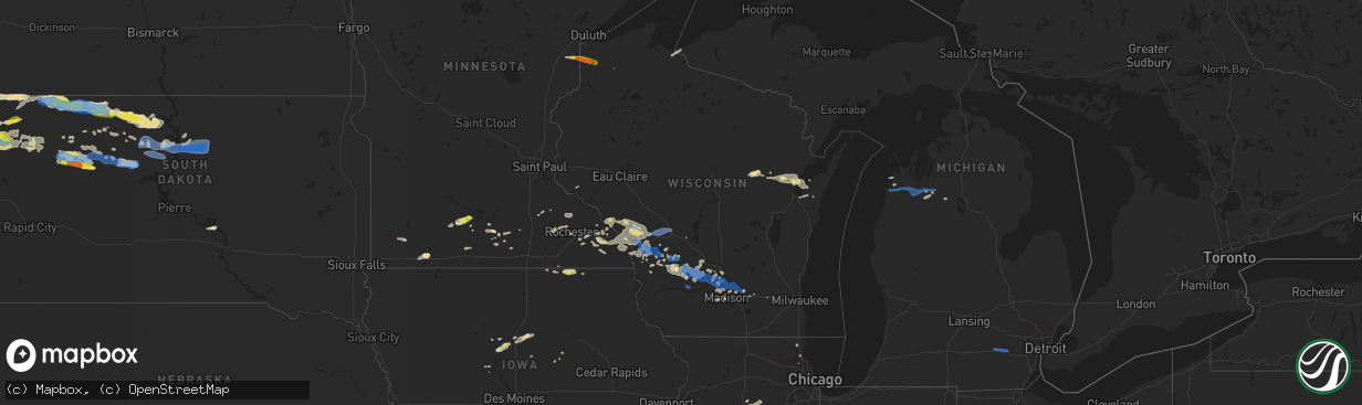
Hail Map in Wisconsin on July 18, 2019
The weather event in Wisconsin on July 18, 2019 includes Hail, Wind, and Tornado maps. 19 states and 432 cities were impacted and suffered possible damage. The total estimated number of properties impacted is 282.
Want more than just the map?
Turn this storm into a full workflow.
- Owner + property data so you know who to knock
- OnDemand branded weather history reports to win the "did we even have hail?" argument
- RoofTrace estimate so reps stop guessing numbers at the door
Bought this map? Upgrade within 7 days and we'll credit the $230. (10-15 min setup call)
Hail
Wind
Tornado
282
Estimated number of impacted properties by a 1.00" hail or larger194
Estimated number of impacted properties by a 1.75" hail or larger0
Estimated number of impacted properties by a 2.50" hail or largerStorm reports in Wisconsin
Wisconsin
| Date | Description |
|---|---|
| 07/18/20192:33 PM CDT | Relayed through douglas co. Sheriffs dept. Time estimated from radar. |
| 07/18/201912:00 PM CDT | Fire department observed relayed through douglas co. Dispatch. |
| 07/18/201911:37 AM CDT | A local report indicates 60 MPH wind near 1 N TOMAH |
| 07/18/20197:08 AM CDT | At 1208 PM CDT, a severe thunderstorm was located 7 miles southeast of Foxboro, or 20 miles south of Superior, moving east at 30 mph. HAZARD...Two inch hail and 60 mph wind gusts. SOURCE...Radar indicated. IMPACT...People and animals outdoors will be injured. Expect hail damage to roofs, siding, windows, and vehicles. Expect wind damage to roofs, siding, and trees. Locations impacted include... Solon Springs, Gordon, Bennett, Chaffey, Amnicon Lake, Lyman Lake, and Saint Croix Flowage. |
| 07/18/20196:51 AM CDT | At 1151 AM CDT, a severe thunderstorm was located over Holyoke, or 20 miles south of Cloquet, moving east at 30 mph. HAZARD...Golf ball size hail and 60 mph wind gusts. SOURCE...Radar indicated. IMPACT...People and animals outdoors will be injured. Expect hail damage to roofs, siding, windows, and vehicles. Expect wind damage to roofs, siding, and trees. Locations impacted include... Holyoke, Foxboro, Chaffey, Harlis, Patzau, Moose Junction, Amnicon Lake, Lyman Lake, and Belden. |
| 07/18/20196:32 AM CDT | At 1131 PM CDT, a severe thunderstorm was located near Fort Mc Coy, or near Tomah, moving east at 45 mph. HAZARD...60 mph wind gusts. SOURCE...Radar indicated. IMPACT...Expect damage to roofs, siding, and trees. This severe thunderstorm will be near... Tomah around 1135 PM CDT.Other locations impacted by this severe thunderstorm include Warrens, Jackson Pass, Normay Ridge, Oakdale, and Tunnel City. |
| 07/18/20196:12 AM CDT | At 1112 PM CDT, a severe thunderstorm was located near Bangor, or 10 miles southwest of Sparta, moving east at 20 mph. HAZARD...60 mph wind gusts and penny size hail. SOURCE...Radar indicated. IMPACT...Expect damage to roofs, siding, and trees. This severe thunderstorm will be near... Cashton around 1145 PM CDT.Other locations impacted by this severe thunderstorm include Brinkman Ridge, Jersey Valley County Park, Irish Hill, Portland, Esofea and Goose Island. |
| 07/18/20191:45 AM CDT | Wires down west of lodi. Time estimated from radar. |
| 07/18/20191:30 AM CDT | A few trees down in spring green. Time estimated from radar. |
| 07/18/20191:25 AM CDT | Tree damage and yard items scattered. Some tree tops broken off. Time estimated from radar. |
| 07/18/20191:01 AM CDT | A few trees down in la valle. Time estimated from radar. |
| 07/18/201912:55 AM CDT | About 10 trees down... Mainly in western parts of sauk county. |
| 07/17/201911:42 PM CDT | Brief tornado damaged farm buildings along wang ridge road... In addition to trees. May have lasted for 1-2 min. Est. Ef0 |
| 07/17/201911:37 PM CDT | A local report indicates 60 MPH wind near 1 N TOMAH |
| 07/17/201911:35 PM CDT | Sporadic wind damage noted along highway 333 from near cashton to middle ridge. Time estimated from radar. |
| 07/17/201911:00 PM CDT | Report of trees down blocking north bound lane on yy. Time estimated based on radar. |
| 07/17/201910:55 PM CDT | A local report indicates 60 MPH wind near 1 NNE MINDORO |
| 07/17/201910:50 PM CDT | At 348 AM CDT, severe thunderstorms were located along a line extending from near Muscoda to near Lancaster, moving southeast at 50 mph. HAZARD...60 mph wind gusts and quarter size hail. SOURCE...Law enforcement. Quarter size hail was reported in Woodman at 345 AM. IMPACT...Hail damage to vehicles is expected. Expect wind damage to roofs, siding, and trees. Severe thunderstorms will be near... Muscoda around 355 AM CDT. Platteville around 410 AM CDT. Cuba City around 415 AM CDT.Other locations impacted by these severe thunderstorms includePreston, Arthur, Highway 61 And County T, Montfort, Mount Ida,Beetown and Union. |
All States Impacted by Hail Map on July 18, 2019
Cities Impacted by Hail Map on July 18, 2019
- Meadow, SD
- Buffalo, SD
- Ludlow, SD
- Cazenovia, WI
- Lilesville, NC
- Kenyon, MN
- Wells, MN
- Cuthbert, GA
- Shellman, GA
- Estill, SC
- Varnville, SC
- Avera, GA
- South Boardman, MI
- Fife Lake, MI
- Marshalltown, IA
- Gladbrook, IA
- Sheridan, IL
- Earlville, IL
- Utica, IL
- Mendota, IL
- Serena, IL
- Ottawa, IL
- Peru, IL
- Troy Grove, IL
- La Salle, IL
- Nashville, NC
- Saint James, MN
- Alzada, MT
- Capitol, MT
- Reva, SD
- Newell, SD
- Belle Fourche, SD
- Mud Butte, SD
- Hammond, MT
- Foxboro, WI
- Gaston, NC
- Blakely, GA
- Hanska, MN
- Metter, GA
- Fort Stewart, GA
- Meigs, GA
- Solon Springs, WI
- Barnum, MN
- Superior, WI
- Holyoke, MN
- Abbeville, AL
- Shorterville, AL
- Loris, SC
- Hampton, SC
- Apopka, FL
- Longwood, FL
- Gresham, WI
- Albany, GA
- Reinbeck, IA
- Abrams, WI
- Faith, SD
- Luxemburg, WI
- Kewaunee, WI
- Alden, IA
- Iowa Falls, IA
- Tabor City, NC
- Viola, WI
- La Farge, WI
- Lawrenceville, VA
- Dupree, SD
- Isabel, SD
- McIntosh, SD
- McLaughlin, SD
- Trail City, SD
- Lodgepole, SD
- Watauga, SD
- Keldron, SD
- Morristown, SD
- Lemmon, SD
- Columbia, AL
- Newville, AL
- Eagle Butte, SD
- Saluda, SC
- Johnston, SC
- Ward, SC
- Camp Crook, SD
- Williams, IA
- Plain, WI
- Hillpoint, WI
- Ekalaka, MT
- Baker, MT
- Okabena, MN
- Brewster, MN
- Lime Springs, IA
- Richland Center, WI
- Hillsboro, WI
- Littleton, NC
- New Ulm, MN
- Sleepy Eye, MN
- Comfrey, MN
- Selby, SD
- Altura, MN
- Rollingstone, MN
- Washington, GA
- Lincolnton, GA
- Duncombe, IA
- Midland City, AL
- Headland, AL
- Kite, GA
- Broadus, MT
- Kasson, MN
- Dodge Center, MN
- Mantorville, MN
- Madison, WI
- Sun Prairie, WI
- Sobieski, WI
- Oconto Falls, WI
- Krakow, WI
- Pulaski, WI
- Otter, MT
- Battleboro, NC
- Roebuck, SC
- Fort Gaines, GA
- Lantry, SD
- Midville, GA
- Swainsboro, GA
- Bartow, GA
- Wadley, GA
- Pinewood, SC
- Summerton, SC
- Saint Stephen, SC
- Stratford, IA
- Adams, MN
- Bison, SD
- McIntire, IA
- Chester, IA
- Riceville, IA
- Claxton, GA
- Soldiers Grove, WI
- Viroqua, WI
- Peterson, MN
- Lanesboro, MN
- Slayton, MN
- Iona, MN
- Chandler, MN
- Kenly, NC
- Smithfield, NC
- Princeton, NC
- Selma, NC
- Pine Level, NC
- Clayton, NC
- Garnett, SC
- Waverly, GA
- West Salem, WI
- Bangor, WI
- Galesville, WI
- Holmen, WI
- Ettrick, WI
- Mindoro, WI
- Melrose, WI
- Baraboo, WI
- Ralph, SD
- Doerun, GA
- Moultrie, GA
- Chaseburg, WI
- La Crosse, WI
- Cashton, WI
- Stoddard, WI
- Westby, WI
- Rockland, WI
- Coon Valley, WI
- Sparta, WI
- Battle Ground, IN
- Brookston, IN
- Merrimac, WI
- Johnsonville, SC
- Naples, FL
- Dawson, GA
- Lyons, GA
- Collins, GA
- Cobbtown, GA
- Maiden Rock, WI
- Hamilton, GA
- Arcadia, WI
- Fountain City, WI
- New Lisbon, WI
- Browns Summit, NC
- Greensboro, NC
- Winona, MN
- Waynesville, GA
- Coleman, GA
- Jesup, GA
- Townsend, GA
- Round O, SC
- Saxon, WI
- Lodi, WI
- Cottageville, SC
- Dakota, MN
- La Crescent, MN
- Poynette, WI
- Manning, SC
- Chatfield, MN
- Cottage Grove, WI
- Deerfield, WI
- Marshall, WI
- West Lafayette, IN
- Rochester, MN
- Oronoco, MN
- Byron, MN
- Leopolis, WI
- Bowler, WI
- Shawano, WI
- Lower Brule, SD
- Ontario, WI
- Norwalk, WI
- Wanamingo, MN
- Brownsville, MN
- Hokah, MN
- Walterboro, SC
- Cloudcroft, NM
- Greeleyville, SC
- Minnesota City, MN
- Tarrytown, GA
- Statesboro, GA
- Brooklet, GA
- Aynor, SC
- Conway, SC
- Galivants Ferry, SC
- Inman, SC
- Traphill, NC
- Twin City, GA
- Little Suamico, WI
- Register, GA
- Good Thunder, MN
- North Freedom, WI
- Lime Ridge, WI
- Loganville, WI
- Reedsburg, WI
- Rock Springs, WI
- La Valle, WI
- Winter Park, FL
- Casselberry, FL
- Winter Springs, FL
- Leesburg, GA
- Mapleton, MN
- New Zion, SC
- Kingstree, SC
- Timber Lake, SD
- Waseca, MN
- Camden, SC
- Middleton, WI
- Waunakee, WI
- Prospect Heights, IL
- Webb, AL
- Ashford, AL
- Norway, SC
- Hartsfield, GA
- Grand Junction, IA
- Sandy Hook, KY
- Tilleda, WI
- Rushford, MN
- Onalaska, WI
- Dodge, WI
- Trempealeau, WI
- Caledonia, MN
- Lewiston, MN
- Utica, MN
- Houston, MN
- Gettysburg, SD
- Kingsley, MI
- Wakpala, SD
- Prairie Du Sac, WI
- Lakefield, MN
- Dover, MN
- Halifax, NC
- Jackson, NC
- Garysburg, NC
- Grand Ridge, IL
- Marseilles, IL
- Dane, WI
- Turbeville, SC
- Libertyville, IL
- Grayslake, IL
- Gurnee, IL
- Sullivan, WI
- Ogden, IA
- Webster City, IA
- Kamrar, IA
- Stanhope, IA
- Jewell, IA
- Elkmont, AL
- Prospect, TN
- Pine Island, MN
- Zumbro Falls, MN
- Mazeppa, MN
- Stacyville, IA
- Osage, IA
- Bronwood, GA
- Rhame, ND
- Pulaski, TN
- Cecil, WI
- Green Sea, SC
- Green Bay, WI
- Waterloo, WI
- Pineville, SC
- Cross, SC
- Truman, MN
- Lugoff, SC
- Pulaski, GA
- Saint Ansgar, IA
- Boyes, MT
- Minnesota Lake, MN
- Saint Charles, MN
- Garden City, MN
- Pemberton, MN
- Janesville, MN
- Spartanburg, SC
- Honor, MI
- Ocoee, FL
- Orlando, FL
- Delavan, MN
- Easton, MN
- Ridgeway, SC
- Bonita Springs, FL
- Lake City, MI
- Brussels, WI
- Eutawville, SC
- Lake Mills, WI
- Gresham, SC
- Darfur, MN
- Moore, SC
- Wrightsville, GA
- Adrian, GA
- Wadesboro, NC
- Rockmart, GA
- Aragon, GA
- New Providence, IA
- Bonduel, WI
- Oconto, WI
- Green Valley, WI
- Suamico, WI
- New Franken, WI
- Gordon, WI
- Fort Thompson, SD
- Denmark, SC
- Olar, SC
- Valentines, VA
- Norman Park, GA
- Batesburg, SC
- Radcliffe, IA
- Windermere, FL
- Winter Garden, FL
- Genoa, WI
- Maria Stein, OH
- Madelia, MN
- Blackville, SC
- Ellsworth, WI
- Verona, WI
- Lake Mary, FL
- Manton, MI
- Fairmont, MN
- Worthington, MN
- Elroy, WI
- Wonewoc, WI
- Johnson Creek, WI
- Orangeburg, SC
- Dothan, AL
- Aiken, SC
- Monetta, SC
- Lyndon Station, WI
- Wisconsin Dells, WI
- Climax, GA
- Empire, MI
- Mankato, MN
- Lincolnshire, IL
- Lake Forest, IL
- South Range, WI
- Van Wert, OH
- Convoy, OH
- Yorkshire, OH
- Piqua, OH
- Fort Loramie, OH
- Houston, OH
- Osgood, OH
- New Weston, OH
- Saint Henry, OH
- Sidney, OH
- Fairfield, OH
- Hamilton, OH
- Hilliard, OH
- Plain City, OH
- West Jefferson, OH
- Ashland, OH
- Greenwich, OH
- New London, OH
- Shiloh, OH
- Nova, OH
- Crooks, SD
- Ridgeview, SD
- Whitehorse, SD
- Java, SD
- Hoven, SD
- Tolstoy, SD
- De Mossville, KY
- Falmouth, KY
- Grawn, MI
- Traverse City, MI
- Benzonia, MI
- Thompsonville, MI
- Buckley, MI
- Beulah, MI
- Interlochen, MI
- Dexter, MI
- Chelsea, MI
- Ann Arbor, MI
- Tomah, WI
- Windsor, WI
- Deforest, WI
- Morrisonville, WI
- Arlington, WI
- Sauk City, WI
- Spring Green, WI
- Lexington, NC
- Graham, NC
- Burlington, NC
- Raleigh, NC
- Pikeville, NC
- Goldsboro, NC
- Sunset, SC
- Salem, SC
- Lyman, SC
- Greer, SC
- Campobello, SC
- Prosperity, SC
- Newberry, SC
- Swansea, SC
- Gaston, SC


