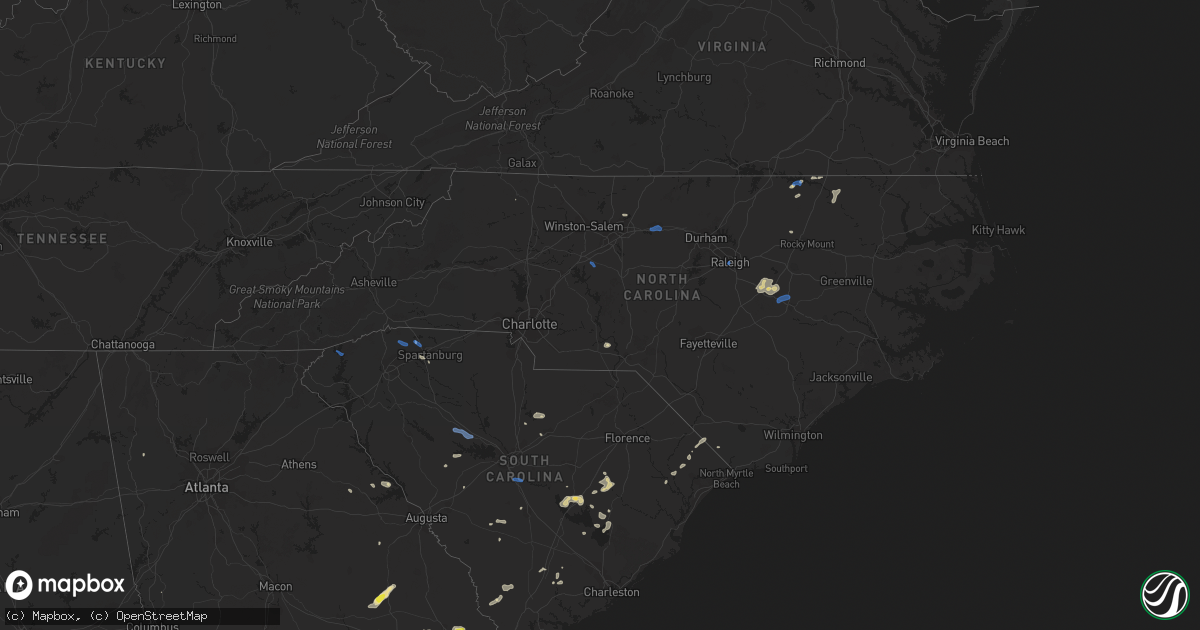
Hail Map in North Carolina on July 18, 2019
Get this storm
July 18 map
$229
one time, instant access
Download today. No call, no setup
Keep the $229
Bought the map and want the full workflow? Apply the entire $229 to a subscription within 7 days. None of it is wasted.
Every map, not just this one
This buys you this map. Subscription and you get every map we run, in the markets you choose from a few cities to whole states to nationwide. Plus real-time alerts the moment a storm fires.
Contact data
Name, contact info, occupancy, even credit band for addresses in the footprint. You go from where it hit to who to call.
Become the source they trust
Unlimited branding weather history reports on demand. You already have the documented answer ready for the property owner, and you are the one who showed up with it.
Property data and RoofTrace estimates
Pull up any address you have got, its value and the exact code rules for that jurisdiction, straight from One Click Code. Then RoofTrace estimates the squares, pitch, and roof value, priced the way you price.
Storm reports in North Carolina
North Carolina
| Date | Description |
|---|---|
| 07/18/20196:30 PM CDT | Measured at a mesonet station in conway... Nc. |
| 07/18/20196:15 PM CDT | Trained spotter reported large 8in diameter tree branch across roadway. Time estimated by radar. |
| 07/18/20196:12 PM CDT | Tree across harden rd. Radar estimated time. |
| 07/18/20196:09 PM CDT | Tree down blocking two lanes of s mebane st. |
| 07/18/20195:24 PM CDT | Tree down near hwy 158. Time estimated by radar. |
| 07/18/20195:18 PM CDT | 2 trees down near hwy 903. Time estimated by radar. |
| 07/18/20195:15 PM CDT | Tree down. Time estimated by radar. |
| 07/18/20194:00 PM CDT | Several trees down near pilot mountain. Time from radar. |
| 07/18/20192:40 PM CDT | Trees down on the 7400 block of old us highway 64. Time estimated by radar. |
| 07/18/20197:22 AM CDT | At 1222 AM EDT, a severe thunderstorm was located 9 miles northwest of Fremont, or 13 miles northeast of Smithfield, moving east at 35 mph. HAZARD...60 mph wind gusts. SOURCE...Radar indicated. IMPACT...Expect damage to roofs, siding, and trees. Locations impacted include... Smithfield, Wilson, Elm City, Fremont, Bailey, Micro, Selma, Sharpsburg, Pine Level and Kenly. |
| 07/18/20197:11 AM CDT | At 1211 AM EDT, a severe thunderstorm was located 7 miles northeast of Smithfield, moving east at 35 mph. HAZARD...60 mph wind gusts. SOURCE...Radar indicated. IMPACT...Expect damage to roofs, siding, and trees. Locations impacted include... Smithfield, Wilson, Elm City, Fremont, Bailey, Micro, Selma, Sharpsburg, Pine Level and Kenly. |
| 07/18/20194:44 AM CDT | At 943 PM EDT, severe thunderstorms were located along a line extending from 8 miles south of Bailey to 8 miles west of Fremont to 7 miles southeast of Smithfield, moving east at 20 mph. HAZARD...60 mph wind gusts. SOURCE...Radar indicated. IMPACT...Expect damage to roofs, siding, and trees. Locations impacted include... Goldsboro, Wilson, Fremont, Kenly, Princeton, Lucama, Black Creek, Pikeville, Eureka and Nahunta. |
| 07/18/20194:21 AM CDT | At 921 PM EDT, severe thunderstorms were located along a line extending from 11 miles southwest of Bailey to 6 miles southwest of Smithfield, moving east at 15 mph. HAZARD...60 mph wind gusts. SOURCE...Radar indicated. IMPACT...Expect damage to roofs, siding, and trees. Locations impacted include... Smithfield, Micro, Selma, Four Oaks, Pine Level, Kenly, Princeton and Buckhorn Reservoir. |
| 07/18/20192:17 AM CDT | At 716 PM EDT, a severe thunderstorm was located 7 miles northwest of Rockingham, moving east at 20 mph. HAZARD...60 mph wind gusts. SOURCE...Radar indicated. IMPACT...Expect damage to roofs, siding, and trees. Locations impacted include... Rockingham, Hamlet, Hoffman, Ellerbe, East Rockingham, Blewett Falls Lake, Derby and Sandhills Game Land. |
| 07/18/20191:48 AM CDT | At 648 PM EDT, a severe thunderstorm was located over Bethel, or 15 miles south of Whiteville, moving east at 20 mph. HAZARD...60 mph wind gusts and quarter size hail. SOURCE...Radar indicated. IMPACT...Minor hail damage to vehicles is possible. Expect wind damage to trees and power lines. Locations impacted include... Bethel, Freeland, Pireway, Ash, Nakina, Dulah, Old Dock, Mollie, Exum, Bughill, Longwood and Crusoe Island. |
| 07/18/20191:40 AM CDT | At 639 PM EDT, a severe thunderstorm was located near Monroeton, or 8 miles northeast of Greensboro, moving east at 25 mph. HAZARD...60 mph wind gusts. SOURCE...Radar indicated. IMPACT...Expect damage to roofs, siding, and trees. Locations impacted include... Greensboro, Burlington, Graham, McLeansville, Elon College, Gibsonville, Haw River, Alamance, Lake Guilford Mackintosh Marina and Lake Burlington. |
| 07/18/20191:13 AM CDT | At 613 PM EDT, a severe thunderstorm was located over Littleton, or 13 miles east of Warrenton, moving northeast at 20 mph. HAZARD...60 mph wind gusts. SOURCE...Radar indicated. IMPACT...Expect damage to roofs, siding, and trees. Locations impacted include... Roanoke Rapids, Halifax, Littleton, Weldon, South Weldon, Airlie, Roanoke Rapids Lake, Rosemary, Lake Gaston and Southpointe And Morningstar Marinas. |
| 07/18/201912:58 AM CDT | At 557 PM EDT, a severe thunderstorm was located near Kernersville, or 7 miles south of Walnut Cove, moving east at 25 mph. HAZARD...60 mph wind gusts. SOURCE...Radar indicated. IMPACT...Expect damage to roofs, siding, and trees. Locations impacted include... Greensboro, Winston-Salem, High Point, Kernersville, Summerfield, Stokesdale, Walkertown, Pleasant Garden, Haw River State Park and Lake Jeanette Marina. |
| 07/17/201910:35 PM CDT | At 335 PM EDT, a severe thunderstorm was located near Lexington, moving east at 15 mph. HAZARD...60 mph wind gusts. SOURCE...Radar indicated. IMPACT...Expect damage to roofs, siding, and trees. Locations impacted include... High Point, Lexington, Denton, Gordontown, Martha and High Rock Lake. |
| 07/17/20198:51 PM CDT | Trees down on power lines on vail road... South of the intersection with perkins road. |
All States Impacted by Hail Map on July 18, 2019
Cities Impacted by Hail Map on July 18, 2019
- Meadow, SD
- Buffalo, SD
- Ludlow, SD
- Cazenovia, WI
- Lilesville, NC
- Kenyon, MN
- Wells, MN
- Cuthbert, GA
- Shellman, GA
- Estill, SC
- Varnville, SC
- Avera, GA
- South Boardman, MI
- Fife Lake, MI
- Marshalltown, IA
- Gladbrook, IA
- Sheridan, IL
- Earlville, IL
- Utica, IL
- Mendota, IL
- Serena, IL
- Ottawa, IL
- Peru, IL
- Troy Grove, IL
- La Salle, IL
- Nashville, NC
- Saint James, MN
- Alzada, MT
- Capitol, MT
- Reva, SD
- Newell, SD
- Belle Fourche, SD
- Mud Butte, SD
- Hammond, MT
- Foxboro, WI
- Gaston, NC
- Blakely, GA
- Hanska, MN
- Metter, GA
- Fort Stewart, GA
- Meigs, GA
- Solon Springs, WI
- Barnum, MN
- Superior, WI
- Holyoke, MN
- Abbeville, AL
- Shorterville, AL
- Loris, SC
- Hampton, SC
- Apopka, FL
- Longwood, FL
- Gresham, WI
- Albany, GA
- Reinbeck, IA
- Abrams, WI
- Faith, SD
- Luxemburg, WI
- Kewaunee, WI
- Alden, IA
- Iowa Falls, IA
- Tabor City, NC
- Viola, WI
- La Farge, WI
- Lawrenceville, VA
- Dupree, SD
- Isabel, SD
- McIntosh, SD
- McLaughlin, SD
- Trail City, SD
- Lodgepole, SD
- Watauga, SD
- Keldron, SD
- Morristown, SD
- Lemmon, SD
- Columbia, AL
- Newville, AL
- Eagle Butte, SD
- Saluda, SC
- Johnston, SC
- Ward, SC
- Camp Crook, SD
- Williams, IA
- Plain, WI
- Hillpoint, WI
- Ekalaka, MT
- Baker, MT
- Okabena, MN
- Brewster, MN
- Lime Springs, IA
- Richland Center, WI
- Hillsboro, WI
- Littleton, NC
- New Ulm, MN
- Sleepy Eye, MN
- Comfrey, MN
- Selby, SD
- Altura, MN
- Rollingstone, MN
- Washington, GA
- Lincolnton, GA
- Duncombe, IA
- Midland City, AL
- Headland, AL
- Kite, GA
- Broadus, MT
- Kasson, MN
- Dodge Center, MN
- Mantorville, MN
- Madison, WI
- Sun Prairie, WI
- Sobieski, WI
- Oconto Falls, WI
- Krakow, WI
- Pulaski, WI
- Otter, MT
- Battleboro, NC
- Roebuck, SC
- Fort Gaines, GA
- Lantry, SD
- Midville, GA
- Swainsboro, GA
- Bartow, GA
- Wadley, GA
- Pinewood, SC
- Summerton, SC
- Saint Stephen, SC
- Stratford, IA
- Adams, MN
- Bison, SD
- McIntire, IA
- Chester, IA
- Riceville, IA
- Claxton, GA
- Soldiers Grove, WI
- Viroqua, WI
- Peterson, MN
- Lanesboro, MN
- Slayton, MN
- Iona, MN
- Chandler, MN
- Kenly, NC
- Smithfield, NC
- Princeton, NC
- Selma, NC
- Pine Level, NC
- Clayton, NC
- Garnett, SC
- Waverly, GA
- West Salem, WI
- Bangor, WI
- Galesville, WI
- Holmen, WI
- Ettrick, WI
- Mindoro, WI
- Melrose, WI
- Baraboo, WI
- Ralph, SD
- Doerun, GA
- Moultrie, GA
- Chaseburg, WI
- La Crosse, WI
- Cashton, WI
- Stoddard, WI
- Westby, WI
- Rockland, WI
- Coon Valley, WI
- Sparta, WI
- Battle Ground, IN
- Brookston, IN
- Merrimac, WI
- Johnsonville, SC
- Naples, FL
- Dawson, GA
- Lyons, GA
- Collins, GA
- Cobbtown, GA
- Maiden Rock, WI
- Hamilton, GA
- Arcadia, WI
- Fountain City, WI
- New Lisbon, WI
- Browns Summit, NC
- Greensboro, NC
- Winona, MN
- Waynesville, GA
- Coleman, GA
- Jesup, GA
- Townsend, GA
- Round O, SC
- Saxon, WI
- Lodi, WI
- Cottageville, SC
- Dakota, MN
- La Crescent, MN
- Poynette, WI
- Manning, SC
- Chatfield, MN
- Cottage Grove, WI
- Deerfield, WI
- Marshall, WI
- West Lafayette, IN
- Rochester, MN
- Oronoco, MN
- Byron, MN
- Leopolis, WI
- Bowler, WI
- Shawano, WI
- Lower Brule, SD
- Ontario, WI
- Norwalk, WI
- Wanamingo, MN
- Brownsville, MN
- Hokah, MN
- Walterboro, SC
- Cloudcroft, NM
- Greeleyville, SC
- Minnesota City, MN
- Tarrytown, GA
- Statesboro, GA
- Brooklet, GA
- Aynor, SC
- Conway, SC
- Galivants Ferry, SC
- Inman, SC
- Traphill, NC
- Twin City, GA
- Little Suamico, WI
- Register, GA
- Good Thunder, MN
- North Freedom, WI
- Lime Ridge, WI
- Loganville, WI
- Reedsburg, WI
- Rock Springs, WI
- La Valle, WI
- Winter Park, FL
- Casselberry, FL
- Winter Springs, FL
- Leesburg, GA
- Mapleton, MN
- New Zion, SC
- Kingstree, SC
- Timber Lake, SD
- Waseca, MN
- Camden, SC
- Middleton, WI
- Waunakee, WI
- Prospect Heights, IL
- Webb, AL
- Ashford, AL
- Norway, SC
- Hartsfield, GA
- Grand Junction, IA
- Sandy Hook, KY
- Tilleda, WI
- Rushford, MN
- Onalaska, WI
- Dodge, WI
- Trempealeau, WI
- Caledonia, MN
- Lewiston, MN
- Utica, MN
- Houston, MN
- Gettysburg, SD
- Kingsley, MI
- Wakpala, SD
- Prairie Du Sac, WI
- Lakefield, MN
- Dover, MN
- Halifax, NC
- Jackson, NC
- Garysburg, NC
- Grand Ridge, IL
- Marseilles, IL
- Dane, WI
- Turbeville, SC
- Libertyville, IL
- Grayslake, IL
- Gurnee, IL
- Sullivan, WI
- Ogden, IA
- Webster City, IA
- Kamrar, IA
- Stanhope, IA
- Jewell, IA
- Elkmont, AL
- Prospect, TN
- Pine Island, MN
- Zumbro Falls, MN
- Mazeppa, MN
- Stacyville, IA
- Osage, IA
- Bronwood, GA
- Rhame, ND
- Pulaski, TN
- Cecil, WI
- Green Sea, SC
- Green Bay, WI
- Waterloo, WI
- Pineville, SC
- Cross, SC
- Truman, MN
- Lugoff, SC
- Pulaski, GA
- Saint Ansgar, IA
- Boyes, MT
- Minnesota Lake, MN
- Saint Charles, MN
- Garden City, MN
- Pemberton, MN
- Janesville, MN
- Spartanburg, SC
- Honor, MI
- Ocoee, FL
- Orlando, FL
- Delavan, MN
- Easton, MN
- Ridgeway, SC
- Bonita Springs, FL
- Lake City, MI
- Brussels, WI
- Eutawville, SC
- Lake Mills, WI
- Gresham, SC
- Darfur, MN
- Moore, SC
- Wrightsville, GA
- Adrian, GA
- Wadesboro, NC
- Rockmart, GA
- Aragon, GA
- New Providence, IA
- Bonduel, WI
- Oconto, WI
- Green Valley, WI
- Suamico, WI
- New Franken, WI
- Gordon, WI
- Fort Thompson, SD
- Denmark, SC
- Olar, SC
- Valentines, VA
- Norman Park, GA
- Batesburg, SC
- Radcliffe, IA
- Windermere, FL
- Winter Garden, FL
- Genoa, WI
- Maria Stein, OH
- Madelia, MN
- Blackville, SC
- Ellsworth, WI
- Verona, WI
- Lake Mary, FL
- Manton, MI
- Fairmont, MN
- Worthington, MN
- Elroy, WI
- Wonewoc, WI
- Johnson Creek, WI
- Orangeburg, SC
- Dothan, AL
- Aiken, SC
- Monetta, SC
- Lyndon Station, WI
- Wisconsin Dells, WI
- Climax, GA
- Empire, MI
- Mankato, MN
- Lincolnshire, IL
- Lake Forest, IL
- South Range, WI
- Van Wert, OH
- Convoy, OH
- Yorkshire, OH
- Piqua, OH
- Fort Loramie, OH
- Houston, OH
- Osgood, OH
- New Weston, OH
- Saint Henry, OH
- Sidney, OH
- Fairfield, OH
- Hamilton, OH
- Hilliard, OH
- Plain City, OH
- West Jefferson, OH
- Ashland, OH
- Greenwich, OH
- New London, OH
- Shiloh, OH
- Nova, OH
- Crooks, SD
- Ridgeview, SD
- Whitehorse, SD
- Java, SD
- Hoven, SD
- Tolstoy, SD
- De Mossville, KY
- Falmouth, KY
- Grawn, MI
- Traverse City, MI
- Benzonia, MI
- Thompsonville, MI
- Buckley, MI
- Beulah, MI
- Interlochen, MI
- Dexter, MI
- Chelsea, MI
- Ann Arbor, MI
- Tomah, WI
- Windsor, WI
- Deforest, WI
- Morrisonville, WI
- Arlington, WI
- Sauk City, WI
- Spring Green, WI
- Lexington, NC
- Graham, NC
- Burlington, NC
- Raleigh, NC
- Pikeville, NC
- Goldsboro, NC
- Sunset, SC
- Salem, SC
- Lyman, SC
- Greer, SC
- Campobello, SC
- Prosperity, SC
- Newberry, SC
- Swansea, SC
- Gaston, SC


