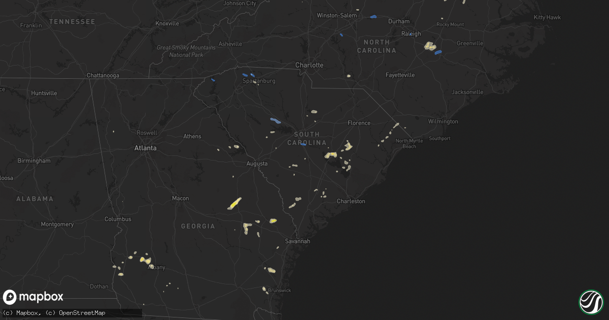
Hail Map in South Carolina on July 18, 2019
Get this storm
July 18 map
$229
one time, instant access
Download today. No call, no setup
Keep the $229
Bought the map and want the full workflow? Apply the entire $229 to a subscription within 7 days. None of it is wasted.
Every map, not just this one
This buys you this map. Subscription and you get every map we run, in the markets you choose from a few cities to whole states to nationwide. Plus real-time alerts the moment a storm fires.
Contact data
Name, contact info, occupancy, even credit band for addresses in the footprint. You go from where it hit to who to call.
Become the source they trust
Unlimited branding weather history reports on demand. You already have the documented answer ready for the property owner, and you are the one who showed up with it.
Property data and RoofTrace estimates
Pull up any address you have got, its value and the exact code rules for that jurisdiction, straight from One Click Code. Then RoofTrace estimates the squares, pitch, and roof value, priced the way you price.
Storm reports in South Carolina
South Carolina
| Date | Description |
|---|---|
| 07/18/20195:42 PM CDT | Report of tree down on st. Paul road. Time estimated by radar. |
| 07/18/20195:35 PM CDT | Trees down on hwy 301. Other locations with trees down in the liberty hill area also. Time estimated by radar. |
| 07/18/20195:08 PM CDT | Powerlines down on church street. Time estimated by radar. |
| 07/18/20195:01 PM CDT | Dot notified of trees down in the vicinity of guinyard street... Garnet street and redmon st. Near the city of orangeburg. |
| 07/18/20194:54 PM CDT | Tree fell through house at 734 partridge road in orangeburg county. Time estimated by radar. |
| 07/18/20194:52 PM CDT | Multiple trees down on levi pond rd in the town of neeses in orangeburg county. Time estimated by radar. |
| 07/18/20194:24 PM CDT | Trained spotter reported 2 structures with missing roofs or other significant roof damage... Damage to car dealership buildings and downed power lines in lugoff. Power |
| 07/18/20194:24 PM CDT | Em reported multiple trees down including a tree down on a car in the boulware road area. Time estimated by radar. |
| 07/18/20194:14 PM CDT | Multiple trees down on rinehart rd between poplar point rd and 500 block of rinehart rd in saluda county. Time estimated by radar. |
| 07/18/20194:12 PM CDT | Tree down on meadows lane and rinehart rd in saluda county. Time estimated by radar. |
| 07/18/20194:06 PM CDT | Tree in roadway. Time estimated by radar. Sc 23 and bethel road in saluda county. Source state highway patrol. |
| 07/18/20194:06 PM CDT | Tree in roadway. Holstein ridge road and burton drive... Saluda county. Highway patrol source. Time estimated by radar. |
| 07/18/20194:03 PM CDT | Tree down 3700 block of hwy 23. Time estimated by radar. |
| 07/18/20194:03 PM CDT | Schp reported tree in roadway us 1 at chinquapin church road. Time estimated by radar. |
| 07/18/20193:26 PM CDT | Tree down on buncomde st in western edgefield county. Time estimated by radar. |
| 07/18/20193:25 PM CDT | Reports of tree limbs down in the dutchman creek area. |
| 07/18/20193:12 PM CDT | Schp reported a tree down at clifton glendale rd and church st |
| 07/18/20193:11 PM CDT | Highway patrol reported tree down on old state road near big beaver creek road. |
| 07/18/20193:06 PM CDT | Tree in roadway in sandy run us 176 and us 21. State highway patrol source. |
| 07/18/20192:52 PM CDT | Schp reported trees and power lines down at highway 176 and petunia rd. |
| 07/18/20192:51 PM CDT | Sc highway patrol reported a tree down near intersection of church lane and sunset drive. |
| 07/18/20192:35 PM CDT | Damage to baseball field on s. Wheeler ave at highway 76 in the town of prosperity in newberry county. Time estimated by radar. |
| 07/18/20192:35 PM CDT | Railroad crossing arms damaged at colony church rd in the town of prosperity in newberry county. Time estimated by radar. |
| 07/18/20192:35 PM CDT | Tree down on circle dr near citgo in the town of prosperity in newberry county. Time estimated by radar. |
| 07/18/20192:35 PM CDT | Powerlines down on highway 76 near wightman church in the town of prosperity in newberry county. Time estimated by radar. |
| 07/18/20192:35 PM CDT | Powerline down on mcneary st in the town of prosperity in newberry county. Time estimated by radar. |
| 07/18/20192:35 PM CDT | Tree down on highway 76 in front of mckechnie vehicle components in the town of prosperity in newberry county. Time estimated by radar. |
| 07/18/20192:35 PM CDT | Tree down on grace st in the town of prosperity in newberry county. Time estimated by radar. |
| 07/18/20192:15 PM CDT | Schp reported a tree down at 4200 jug factory rd |
| 07/18/20191:00 PM CDT | *** 2 fatal... 2 inj *** portion of home under contruction collapsed. |
| 07/18/201912:52 PM CDT | *** 2 fatal... 2 inj *** report of several trees and powerlines down... As well as structural damage to a home that was under construction and collapsed. Time estimated |
| 07/18/20191:50 AM CDT | At 649 PM EDT, severe thunderstorms were located along a line extending from 10 miles west of Kingstree to 18 miles northeast of Indian Field, moving southeast at 35 mph. HAZARD...60 mph wind gusts and penny size hail. SOURCE...Radar indicated. IMPACT...Expect damage to trees and powerlines. Locations impacted include... Moncks Corner, St. Stephen, Bonneau, Southern Lake Moultrie, Eadytown, Cross, Northern Lake Moultrie and Bonneau Beach. |
| 07/18/20191:37 AM CDT | At 637 PM EDT, a severe thunderstorm was located over Summerton, or 12 miles southwest of Manning, moving southeast at 25 mph. HAZARD...60 mph wind gusts. SOURCE...Law enforcement reported trees down. This storm has a history of producing strong damaging winds. IMPACT...Expect damage to roofs, siding, and trees. Locations impacted include... Summerton, Santee State Park, Santee Cooper Regional Airport, Eautaw Springs, Poplar Creek Landing, St. Paul, Davis Station, Rocks Pond Campground and Marina and Blounts Landing.This includes Interstate 95 between mile markers 100 and 113. |
| 07/18/20191:37 AM CDT | At 637 PM EDT, a severe thunderstorm was located near Hebron, or 9 miles northwest of Kingstree, moving east at 20 mph. HAZARD...60 mph wind gusts and quarter size hail. SOURCE...Radar indicated. IMPACT...Minor hail damage to vehicles is possible. Expect wind damage to trees and power lines. Locations impacted include... Lake City, Kingstree, Trio, Salters, Hebron, Cades, Gourdin, Lane, Greeleyville and Williamsburg Regional Hospital. |
| 07/18/20191:28 AM CDT | At 628 PM EDT, a severe thunderstorm was located over Manning, moving southeast at 30 mph. HAZARD...60 mph wind gusts. SOURCE...Radar indicated. IMPACT...Expect damage to roofs, siding, and trees. Locations impacted include... Manning, Santee Cooper Regional Airport and Foreston. This includes Interstate 95 between mile markers 114 and 122. |
| 07/18/20191:25 AM CDT | At 624 PM EDT, a severe thunderstorm was located 7 miles west of Elloree, or 7 miles east of Brookdale, moving southeast at 40 mph. HAZARD...70 mph wind gusts and quarter size hail. SOURCE...Law enforcement reports trees down across portions of central Orangeburg County. This storm has a history of producing strong damaging winds. IMPACT...Hail damage to vehicles is expected. Expect considerable tree damage. Wind damage is also likely to mobile homes, roofs, and outbuildings. Locations impacted include... Brookdale, Holly Hill, Bowman, Elloree, Santee, Cameron, Eutawville, Vance, Yonder Field, Eautaw Springs, Indian Bluff Recreation Park, Creston, Mill Creek Marina and Campground and Wilkinson Heights.This includes the following highways... Interstate 26 between mile markers 147 and 168. Interstate 95 between mile markers 86 and 99. |
| 07/18/201912:58 AM CDT | At 558 PM EDT, a severe thunderstorm was located near Santee State Park, or 16 miles west of Manning, moving southeast at 35 mph. HAZARD...60 mph wind gusts and nickel size hail. SOURCE...Radar indicated. IMPACT...Expect damage to roofs, siding, and trees. Locations impacted include... Summerton, Santee State Park, Santee Cooper Regional Airport, Santee, Pinewood, Eutawville, Vance, Poplar Creek Landing, Rimini, St. Paul, Stumphole Landing, Rocks Pond Campground and Marina, Eautaw Springs, Indian Bluff Recreation Park, Davis Station, Blounts Landing, Mill Creek Marina and Campground, Lone Star and Low Falls Landing.This includes Interstate 95 between mile markers 97 and 112. |
| 07/18/201912:48 AM CDT | At 547 PM EDT, a severe thunderstorm was located over Orangeburg, moving southeast at 40 mph. HAZARD...60 mph wind gusts. SOURCE...Radar indicated. IMPACT...Expect damage to roofs, siding, and trees. Locations impacted include... Orangeburg, Brookdale, St. Matthews, Bowman, Elloree, Orangeburg County Airport, Claflin College, Edisto Gardens, South Carolina State University, Santee, Cameron, Rowesville, Cordova, Yonder Field, Wilkinson Heights, Prince of Orange Mall and Edisto.This includes the following highways... Interstate 26 between mile markers 138 and 166. Interstate 95 between mile markers 94 and 97. |
| 07/18/201912:12 AM CDT | At 511 PM EDT, a severe thunderstorm was located 8 miles east of Saluda, or 10 miles northwest of Batesburg-Leesville, moving east at 30 mph. HAZARD...60 mph wind gusts. SOURCE...Radar indicated. IMPACT...Expect damage to roofs, siding, and trees. Locations impacted include... Dreher Island State Park, Summit, Cedar Grove Fire Station, South Shore Marina, Oswald Park, Murray, Hollywood Elementary School, Emory, Lake Murray Shores, Circle Fire Station, Delmar, Hollow Creek Public Park and Riverbend Boat Ramp. |
| 07/18/201912:03 AM CDT | At 503 PM EDT, a severe thunderstorm was located over Longtown, or 7 miles west of Lake Wateree Dam, moving southeast at 20 mph. HAZARD...60 mph wind gusts. SOURCE...Radar indicated. IMPACT...Expect damage to roofs, siding, and trees. Locations impacted include... Camden, Lake Wateree Dam, Lugoff, Longtown, Ridgeway, Pine Grove Fire Station, North Towne Square Shopping Center and Woodward Airfield.This includes Interstate 20 in South Carolina between mile markers 87and 97. |
| 07/18/201912:00 AM CDT | At 500 PM EDT, a severe thunderstorm was located near Batesburg-Leesville, moving east at 40 mph. HAZARD...60 mph wind gusts. SOURCE...Radar indicated. IMPACT...Expect damage to roofs, siding, and trees. Locations impacted include... Batesburg-Leesville, Red Bank, Ridge Spring, Saluda County Airport, Gilbert, Summit, Monetta, Ward, Fredonia, Murray, Camp Kinard, Emory, Hibernia, Steedman, Kneece, Samaria Fire Station, Cedar Pond Campground and Saluda Co Sheriff's Office.This includes Interstate 20 in South Carolina between mile markers 31and 53. |
| 07/17/201911:24 PM CDT | At 424 PM EDT, a severe thunderstorm was located 9 miles northwest of Union, or 4 miles southwest of Jonesville, moving southeast at 10 mph. HAZARD...60 mph wind gusts and penny size hail. SOURCE...Radar indicated. IMPACT...Expect damage to trees and power lines. Locations impacted include... Buffalo, Jonesville and Union. |
| 07/17/201911:08 PM CDT | At 408 PM EDT, a severe thunderstorm was located near Mistletoe State Park, or 11 miles north of Thomson, moving east at 30 mph. HAZARD...70 mph wind gusts and quarter size hail. SOURCE...Radar indicated. IMPACT...Hail damage to vehicles is expected. Expect considerable tree damage. Wind damage is also likely to mobile homes, roofs, and outbuildings. Locations impacted include... Grovetown, Evans, Martinez, Appling, Clarks Hill Recreation Area, J. Strom Thurmond Dam, Riverwood, Mistletoe State Park, Thomson-McDuffie County Airport, Wrightsboro, Winfield, Scott's Landing, White Oak Campground, Columbia County Jail, Blanchard Park, Wildwood Park, Ansley Mill, Eubank-Blanchard Community Center, Westmont and Bussey Point Campground.This includes Interstate 20 in Georgia between mile markers 172 and193. |
| 07/17/201911:04 PM CDT | At 404 PM EDT, a severe thunderstorm was located over Sandy Run, or 12 miles southeast of Cayce, moving east at 30 mph. HAZARD...60 mph wind gusts. SOURCE...Radar indicated. IMPACT...Expect damage to roofs, siding, and trees. Locations impacted include... St. Matthews, Gadsden, Congaree National Park, Sandy Run, Cameron, New Zion and Fort Motte.This includes Interstate 26 between mile markers 121 and 140. |
| 07/17/201911:02 PM CDT | At 402 PM EDT, severe thunderstorms were located along a line extending from 9 miles southwest of Ninety Six Historic Site to near J. Strom Thurmond Dam, moving east at 25 mph. HAZARD...70 mph wind gusts. SOURCE...Radar indicated. IMPACT...Expect considerable tree damage. Damage is likely to mobile homes, roofs, and outbuildings. Locations impacted include... North Augusta, Augusta, Clearwater, Belvedere, Martinez, Edgefield, Saluda, Johnston, Clarks Hill Recreation Area, Edgefield County Airport, Hamilton Branch State Park, Augusta National Golf Club, Saluda County Airport, J. Strom Thurmond Dam, Burnettown, Trenton, Parksville, Plum Branch, West End Augusta and Saluda Co Sheriff's Office.This includes the following highways... Interstate 20 in Georgia between mile markers 199 and 201. Interstate 20 in South Carolina between mile markers 0 and 11. Interstate 520 in Georgia between mile markers 14 and 15. Interstate 520 in South Carolina between mile markers 16 and 23. |
| 07/17/201910:59 PM CDT | At 358 PM EDT, a severe thunderstorm was located over Dreher Island State Park, or 11 miles northwest of Lake Murray Dam, moving southeast at 25 mph. HAZARD...70 mph wind gusts and quarter size hail. SOURCE...Emergency management multiple trees down across Newberry County near the Prosperity area. IMPACT...Hail damage to vehicles is expected. Expect considerable tree damage. Wind damage is also likely to mobile homes, roofs, and outbuildings. Locations impacted include... Lexington, Irmo, Lake Murray Dam, Prosperity, Jenkinsville, Ballentine, Dreher Island State Park, Chapin, Little Mountain, Pomaria, Peak, South Shore Marina, Oswald Park, Bundrick Island, Putnam's Landing, White Rock, Rocky Point Recreation Area, Hollow Creek Public Park, Melvin Park and Lighthouse Marina.This includes Interstate 26 between mile markers 82 and 101. |
| 07/17/201910:50 PM CDT | At 348 PM EDT, a severe thunderstorm was located just northwest of Lake Wateree, moving east-southeast at 20 mph. HAZARD...60 mph wind gusts and quarter size hail. SOURCE...Radar indicated. IMPACT...Hail damage to vehicles is expected. Expect wind damage to roofs, siding, and trees. Locations impacted include... Lake Wateree, Camden, Lake Wateree Dam, Westville, Longtown, Liberty Hill, Goodale State Park, Lake Wateree State Park, North Central High School, Dekalb, North Towne Square Shopping Center, Midway Elementary School, Woodward Airfield and Lake Wateree near Highway 97.This includes Interstate 20 in South Carolina between mile markers 99and 101. |
| 07/17/201910:49 PM CDT | At 349 PM EDT, a severe thunderstorm was located over Lake Wateree State Park, or 10 miles northwest of Lake Wateree Dam, moving east at 20 mph. HAZARD...60 mph wind gusts. SOURCE...Radar indicated. IMPACT...Expect damage to roofs, siding, and trees. Locations impacted include... Lake Wateree Dam, Kershaw, Westville, Liberty Hill, Lake Wateree State Park, Longtown, Dekalb and Lake Wateree near Highway 97. |
| 07/17/201910:43 PM CDT | At 342 PM EDT, a severe thunderstorm was located 9 miles northwest of Spartanburg, or near Inman, moving southeast at 15 mph. HAZARD...60 mph wind gusts. SOURCE...Radar indicated. IMPACT...Expect damage to trees and power lines. Locations impacted include... Spartanburg, Boiling Springs SC, Lyman, Wellford, Inman, Roebuck, Lake Bowen, USC Upstate, Cowpens and Duncan. |
| 07/17/201910:27 PM CDT | At 327 PM EDT, a severe thunderstorm was located over Prosperity, or near Newberry, moving east at 35 mph. HAZARD...60 mph wind gusts and nickel size hail. SOURCE...Radar indicated. IMPACT...Expect damage to roofs, siding, and trees. Locations impacted include... Newberry, Prosperity, Newberry College, Dreher Island State Park, Chapin, Little Mountain, Pomaria, Silverstreet, Peak, Cedar Grove Fire Station, South Shore Marina, Oswald Park, Putnam's Landing, White Rock, Rocky Point Recreation Area, Hollow Creek Public Park, Melvin Park, Lighthouse Marina, Stoney Hill and Shull Island.This includes Interstate 26 between mile markers 76 and 96. |
| 07/17/201910:22 PM CDT | At 322 PM EDT, a severe thunderstorm was located over Lincolnton, or 12 miles east of Washington, moving east at 25 mph. HAZARD...60 mph wind gusts and penny size hail. SOURCE...Radar indicated. IMPACT...Expect damage to roofs, siding, and trees. Locations impacted include... McCormick, Lincolnton, Mccormick County Airport, Hamilton Branch State Park, Elijah Clark State Park, Parksville, Plum Branch, Hickory Knob State Resort Park, Loce, Baker Creek State Park, Modoc, Knox Scout Reservation, Woodlawn, Modoc Campground, Double Branches, Curry Hill, Modoc Boat Ramp, Hawe Creek Campground, New Hope and Long Cane Creek Picnic Area. |
| 07/17/201910:12 PM CDT | At 312 PM EDT, a severe thunderstorm was located 6 miles southeast of Columbus, or near Landrum, moving southeast at 10 mph. HAZARD...60 mph wind gusts and penny size hail. SOURCE...Radar indicated. IMPACT...Expect damage to trees and power lines. Locations impacted include... Columbus, Landrum, Inman, Tryon, Campobello, Lake Bowen, Gowensville, Green Creek, Fingerville and Mill Spring. |
| 07/17/201910:03 PM CDT | At 302 PM EDT, a severe thunderstorm was located 14 miles north of Greenville Downtown, or over Tigerville, moving southeast at 15 mph. HAZARD...60 mph wind gusts. SOURCE...Radar indicated. IMPACT...Expect damage to trees and power lines. Locations impacted include... Greer, Taylors, Inman, Tigerville, Lake Robinson, Gowensville, Glassy Mountain, Campobello, Paris Mountain State Park and Slater-Marietta. |
All States Impacted by Hail Map on July 18, 2019
Cities Impacted by Hail Map on July 18, 2019
- Meadow, SD
- Buffalo, SD
- Ludlow, SD
- Cazenovia, WI
- Lilesville, NC
- Kenyon, MN
- Wells, MN
- Cuthbert, GA
- Shellman, GA
- Estill, SC
- Varnville, SC
- Avera, GA
- South Boardman, MI
- Fife Lake, MI
- Marshalltown, IA
- Gladbrook, IA
- Sheridan, IL
- Earlville, IL
- Utica, IL
- Mendota, IL
- Serena, IL
- Ottawa, IL
- Peru, IL
- Troy Grove, IL
- La Salle, IL
- Nashville, NC
- Saint James, MN
- Alzada, MT
- Capitol, MT
- Reva, SD
- Newell, SD
- Belle Fourche, SD
- Mud Butte, SD
- Hammond, MT
- Foxboro, WI
- Gaston, NC
- Blakely, GA
- Hanska, MN
- Metter, GA
- Fort Stewart, GA
- Meigs, GA
- Solon Springs, WI
- Barnum, MN
- Superior, WI
- Holyoke, MN
- Abbeville, AL
- Shorterville, AL
- Loris, SC
- Hampton, SC
- Apopka, FL
- Longwood, FL
- Gresham, WI
- Albany, GA
- Reinbeck, IA
- Abrams, WI
- Faith, SD
- Luxemburg, WI
- Kewaunee, WI
- Alden, IA
- Iowa Falls, IA
- Tabor City, NC
- Viola, WI
- La Farge, WI
- Lawrenceville, VA
- Dupree, SD
- Isabel, SD
- McIntosh, SD
- McLaughlin, SD
- Trail City, SD
- Lodgepole, SD
- Watauga, SD
- Keldron, SD
- Morristown, SD
- Lemmon, SD
- Columbia, AL
- Newville, AL
- Eagle Butte, SD
- Saluda, SC
- Johnston, SC
- Ward, SC
- Camp Crook, SD
- Williams, IA
- Plain, WI
- Hillpoint, WI
- Ekalaka, MT
- Baker, MT
- Okabena, MN
- Brewster, MN
- Lime Springs, IA
- Richland Center, WI
- Hillsboro, WI
- Littleton, NC
- New Ulm, MN
- Sleepy Eye, MN
- Comfrey, MN
- Selby, SD
- Altura, MN
- Rollingstone, MN
- Washington, GA
- Lincolnton, GA
- Duncombe, IA
- Midland City, AL
- Headland, AL
- Kite, GA
- Broadus, MT
- Kasson, MN
- Dodge Center, MN
- Mantorville, MN
- Madison, WI
- Sun Prairie, WI
- Sobieski, WI
- Oconto Falls, WI
- Krakow, WI
- Pulaski, WI
- Otter, MT
- Battleboro, NC
- Roebuck, SC
- Fort Gaines, GA
- Lantry, SD
- Midville, GA
- Swainsboro, GA
- Bartow, GA
- Wadley, GA
- Pinewood, SC
- Summerton, SC
- Saint Stephen, SC
- Stratford, IA
- Adams, MN
- Bison, SD
- McIntire, IA
- Chester, IA
- Riceville, IA
- Claxton, GA
- Soldiers Grove, WI
- Viroqua, WI
- Peterson, MN
- Lanesboro, MN
- Slayton, MN
- Iona, MN
- Chandler, MN
- Kenly, NC
- Smithfield, NC
- Princeton, NC
- Selma, NC
- Pine Level, NC
- Clayton, NC
- Garnett, SC
- Waverly, GA
- West Salem, WI
- Bangor, WI
- Galesville, WI
- Holmen, WI
- Ettrick, WI
- Mindoro, WI
- Melrose, WI
- Baraboo, WI
- Ralph, SD
- Doerun, GA
- Moultrie, GA
- Chaseburg, WI
- La Crosse, WI
- Cashton, WI
- Stoddard, WI
- Westby, WI
- Rockland, WI
- Coon Valley, WI
- Sparta, WI
- Battle Ground, IN
- Brookston, IN
- Merrimac, WI
- Johnsonville, SC
- Naples, FL
- Dawson, GA
- Lyons, GA
- Collins, GA
- Cobbtown, GA
- Maiden Rock, WI
- Hamilton, GA
- Arcadia, WI
- Fountain City, WI
- New Lisbon, WI
- Browns Summit, NC
- Greensboro, NC
- Winona, MN
- Waynesville, GA
- Coleman, GA
- Jesup, GA
- Townsend, GA
- Round O, SC
- Saxon, WI
- Lodi, WI
- Cottageville, SC
- Dakota, MN
- La Crescent, MN
- Poynette, WI
- Manning, SC
- Chatfield, MN
- Cottage Grove, WI
- Deerfield, WI
- Marshall, WI
- West Lafayette, IN
- Rochester, MN
- Oronoco, MN
- Byron, MN
- Leopolis, WI
- Bowler, WI
- Shawano, WI
- Lower Brule, SD
- Ontario, WI
- Norwalk, WI
- Wanamingo, MN
- Brownsville, MN
- Hokah, MN
- Walterboro, SC
- Cloudcroft, NM
- Greeleyville, SC
- Minnesota City, MN
- Tarrytown, GA
- Statesboro, GA
- Brooklet, GA
- Aynor, SC
- Conway, SC
- Galivants Ferry, SC
- Inman, SC
- Traphill, NC
- Twin City, GA
- Little Suamico, WI
- Register, GA
- Good Thunder, MN
- North Freedom, WI
- Lime Ridge, WI
- Loganville, WI
- Reedsburg, WI
- Rock Springs, WI
- La Valle, WI
- Winter Park, FL
- Casselberry, FL
- Winter Springs, FL
- Leesburg, GA
- Mapleton, MN
- New Zion, SC
- Kingstree, SC
- Timber Lake, SD
- Waseca, MN
- Camden, SC
- Middleton, WI
- Waunakee, WI
- Prospect Heights, IL
- Webb, AL
- Ashford, AL
- Norway, SC
- Hartsfield, GA
- Grand Junction, IA
- Sandy Hook, KY
- Tilleda, WI
- Rushford, MN
- Onalaska, WI
- Dodge, WI
- Trempealeau, WI
- Caledonia, MN
- Lewiston, MN
- Utica, MN
- Houston, MN
- Gettysburg, SD
- Kingsley, MI
- Wakpala, SD
- Prairie Du Sac, WI
- Lakefield, MN
- Dover, MN
- Halifax, NC
- Jackson, NC
- Garysburg, NC
- Grand Ridge, IL
- Marseilles, IL
- Dane, WI
- Turbeville, SC
- Libertyville, IL
- Grayslake, IL
- Gurnee, IL
- Sullivan, WI
- Ogden, IA
- Webster City, IA
- Kamrar, IA
- Stanhope, IA
- Jewell, IA
- Elkmont, AL
- Prospect, TN
- Pine Island, MN
- Zumbro Falls, MN
- Mazeppa, MN
- Stacyville, IA
- Osage, IA
- Bronwood, GA
- Rhame, ND
- Pulaski, TN
- Cecil, WI
- Green Sea, SC
- Green Bay, WI
- Waterloo, WI
- Pineville, SC
- Cross, SC
- Truman, MN
- Lugoff, SC
- Pulaski, GA
- Saint Ansgar, IA
- Boyes, MT
- Minnesota Lake, MN
- Saint Charles, MN
- Garden City, MN
- Pemberton, MN
- Janesville, MN
- Spartanburg, SC
- Honor, MI
- Ocoee, FL
- Orlando, FL
- Delavan, MN
- Easton, MN
- Ridgeway, SC
- Bonita Springs, FL
- Lake City, MI
- Brussels, WI
- Eutawville, SC
- Lake Mills, WI
- Gresham, SC
- Darfur, MN
- Moore, SC
- Wrightsville, GA
- Adrian, GA
- Wadesboro, NC
- Rockmart, GA
- Aragon, GA
- New Providence, IA
- Bonduel, WI
- Oconto, WI
- Green Valley, WI
- Suamico, WI
- New Franken, WI
- Gordon, WI
- Fort Thompson, SD
- Denmark, SC
- Olar, SC
- Valentines, VA
- Norman Park, GA
- Batesburg, SC
- Radcliffe, IA
- Windermere, FL
- Winter Garden, FL
- Genoa, WI
- Maria Stein, OH
- Madelia, MN
- Blackville, SC
- Ellsworth, WI
- Verona, WI
- Lake Mary, FL
- Manton, MI
- Fairmont, MN
- Worthington, MN
- Elroy, WI
- Wonewoc, WI
- Johnson Creek, WI
- Orangeburg, SC
- Dothan, AL
- Aiken, SC
- Monetta, SC
- Lyndon Station, WI
- Wisconsin Dells, WI
- Climax, GA
- Empire, MI
- Mankato, MN
- Lincolnshire, IL
- Lake Forest, IL
- South Range, WI
- Van Wert, OH
- Convoy, OH
- Yorkshire, OH
- Piqua, OH
- Fort Loramie, OH
- Houston, OH
- Osgood, OH
- New Weston, OH
- Saint Henry, OH
- Sidney, OH
- Fairfield, OH
- Hamilton, OH
- Hilliard, OH
- Plain City, OH
- West Jefferson, OH
- Ashland, OH
- Greenwich, OH
- New London, OH
- Shiloh, OH
- Nova, OH
- Crooks, SD
- Ridgeview, SD
- Whitehorse, SD
- Java, SD
- Hoven, SD
- Tolstoy, SD
- De Mossville, KY
- Falmouth, KY
- Grawn, MI
- Traverse City, MI
- Benzonia, MI
- Thompsonville, MI
- Buckley, MI
- Beulah, MI
- Interlochen, MI
- Dexter, MI
- Chelsea, MI
- Ann Arbor, MI
- Tomah, WI
- Windsor, WI
- Deforest, WI
- Morrisonville, WI
- Arlington, WI
- Sauk City, WI
- Spring Green, WI
- Lexington, NC
- Graham, NC
- Burlington, NC
- Raleigh, NC
- Pikeville, NC
- Goldsboro, NC
- Sunset, SC
- Salem, SC
- Lyman, SC
- Greer, SC
- Campobello, SC
- Prosperity, SC
- Newberry, SC
- Swansea, SC
- Gaston, SC


