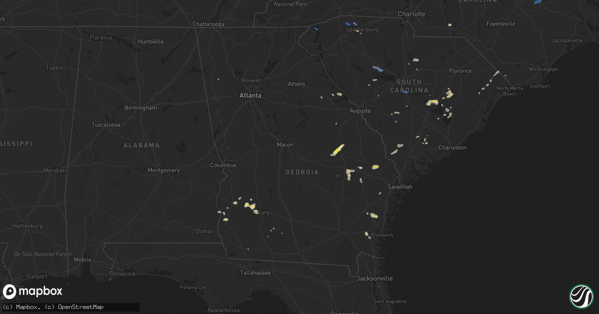
Hail Map in Georgia on July 18, 2019
Get this storm
July 18 map
$229
one time, instant access
Download today. No call, no setup
Keep the $229
Bought the map and want the full workflow? Apply the entire $229 to a subscription within 7 days. None of it is wasted.
Every map, not just this one
This buys you this map. Subscription and you get every map we run, in the markets you choose from a few cities to whole states to nationwide. Plus real-time alerts the moment a storm fires.
Contact data
Name, contact info, occupancy, even credit band for addresses in the footprint. You go from where it hit to who to call.
Become the source they trust
Unlimited branding weather history reports on demand. You already have the documented answer ready for the property owner, and you are the one who showed up with it.
Property data and RoofTrace estimates
Pull up any address you have got, its value and the exact code rules for that jurisdiction, straight from One Click Code. Then RoofTrace estimates the squares, pitch, and roof value, priced the way you price.
Storm reports in Georgia
Georgia
| Date | Description |
|---|---|
| 07/18/20196:30 PM CDT | Tree down on 1st kolomoki road between sawyer road and marys lane. |
| 07/18/20196:23 PM CDT | The bulloch county 911 center reported a tree down on stilson leefield road. Time is estimated by radar data. |
| 07/18/20196:20 PM CDT | A broadcast media relayed a report of hail in brooklet. Time is estimated by radar. |
| 07/18/20196:15 PM CDT | A broadcast media relayed a report of hail in brooklet. Time is estimated by radar. |
| 07/18/20196:04 PM CDT | A tree was reported down on hwy 251 and hwy 57. Time is estimated by radar data. |
| 07/18/20196:01 PM CDT | A tree was reported down on sinkhole road between g w oliver road and hwy 46. Time is estimated by radar. |
| 07/18/20195:21 PM CDT | Minor damage to a few residences along price williams rd |
| 07/18/20195:21 PM CDT | Damage to the porches of a few residences along williams and price rd. Also at least one powerline down and at least one tree down along this road. |
| 07/18/20195:20 PM CDT | Power lines down on gillianville rd in albany... Ga. |
| 07/18/20194:55 PM CDT | Powerline down and 6 trees down in lee county... Ga. Most of this damage is along hwy 82. |
| 07/18/20194:50 PM CDT | *** 6 inj *** the military police relayed a report that a tent was blown over during a training exercise resulting in six minor injuries. It occurred near evans army ai |
| 07/18/20194:35 PM CDT | 3 trees down near parrott... Ga. |
| 07/18/20193:25 PM CDT | Gdot reported tree down on i-16 eastbound at the mlk jr. Blvd. Exit |
| 07/18/20193:18 PM CDT | Tree reported down in mistletoe state park. Time estimated by radar. |
| 07/18/20192:31 PM CDT | Powerline down on thompson highway in lincoln county. Time estimated by radar. |
| 07/18/20192:24 PM CDT | Tree down with structual damage near the intersection of phillips rd. And phillips ct. In lithonia |
| 07/18/20192:16 PM CDT | Tree limb down... Taking down powerlines in downtown lincolnton in lincoln county. Time estimated by radar. |
| 07/18/20192:12 PM CDT | Trees and power lines down in lincolnton. |
| 07/18/201912:55 PM CDT | Large oak tree down across e gordon rd... Blocking roadway. |
| 07/18/201910:50 AM CDT | *** 1 inj *** multiple trees were downed in the town of helen. 4 trees fell across the chattahoochee river where a child recieved a minor injury while tubing. A tree wa |
| 07/18/20193:35 AM CDT | At 835 PM EDT, a severe thunderstorm was located near Waynesville, or 12 miles east of Nahunta, moving east at 5 mph. HAZARD...60 mph wind gusts and quarter size hail. SOURCE...Radar indicated. IMPACT...Hail damage to vehicles is expected. Expect wind damage to roofs, siding, and trees. Locations impacted include... Waverly, Waynesville and Atkinson. |
| 07/18/20192:24 AM CDT | At 724 PM EDT, a severe thunderstorm was located 7 miles north of Blakely, moving east at 35 mph. HAZARD...60 mph wind gusts. SOURCE...Radar indicated. IMPACT...Expect damage to roofs, siding, and trees. Locations impacted include... Fort Gaines, Morgan, Blakely, Edison, Arlington, Bellville, Bluffton, Parksville, Carnegie, Pecan, Aycock Mill, Early Co A/p, Jones Crossing, Martins Crossroads, Suttons Corner, Fort Gaines-Clay Airport, Harrisons Mill, Zetto, Moye and Cordrays Mill. |
| 07/18/20192:17 AM CDT | At 716 PM EDT, a severe thunderstorm was located 11 miles east of Statesboro, moving east at 30 mph. HAZARD...60 mph wind gusts and quarter size hail. SOURCE...Radar indicated. IMPACT...Minor hail damage to vehicles is possible. Expect wind damage to trees and powerlines. Locations impacted include... Statesboro, Guyton, Brooklet, Oliver, Pineora, Egypt, Shawnee and Leefield. |
| 07/18/20191:55 AM CDT | At 655 PM EDT, a severe thunderstorm was located over Metter, and is nearly stationary. HAZARD...60 mph wind gusts. SOURCE...Radar indicated. IMPACT...Expect damage to trees and powerlines. Locations impacted include... Statesboro, Metter, Westside, Portal, Pulaski, Register, Aline and Georgia Southern.This warning includes I-16 between mile markers 100 and 120. |
| 07/18/20191:45 AM CDT | At 645 PM EDT, a severe thunderstorm was located over Blundale, or 12 miles north of Swainsboro, moving northeast at 20 mph. HAZARD...60 mph wind gusts and penny size hail. SOURCE...Radar indicated. IMPACT...Expect damage to roofs, siding, and trees. Locations impacted include... Wadley, Summertown, Blundale, Three Points and Colemans Lake. |
| 07/18/20191:39 AM CDT | At 638 PM EDT, a severe thunderstorm was located near Tibet, moving east at 10 mph. HAZARD...60 mph wind gusts. SOURCE...Radar indicated. IMPACT...Expect damage to roofs, siding, and trees. Locations impacted include... Mount Pleasant. |
| 07/18/20191:29 AM CDT | At 629 PM EDT, a severe thunderstorm was located near Tibet, moving east at 10 mph. HAZARD...60 mph wind gusts and quarter size hail. SOURCE...Radar indicated. IMPACT...Minor hail damage to vehicles is possible. Expect wind damage to trees and powerlines. Locations impacted include... Tibet, Jones, Eulonia and Townsend. This warning includes I-95 in Georgia between mile markers 58 and 63. |
| 07/18/20191:18 AM CDT | At 618 PM EDT, a severe thunderstorm was located over Kite, or 10 miles northwest of Swainsboro, moving east at 15 mph. HAZARD...60 mph wind gusts and quarter size hail. SOURCE...Radar indicated. IMPACT...Hail damage to vehicles is expected. Expect wind damage to roofs, siding, and trees. Locations impacted include... Swainsboro, Adrian, Summertown, Kite, Norristown Junction, Dellwood, Modoc, Meeks and Blundale. |
| 07/18/201912:45 AM CDT | At 545 PM EDT, a severe thunderstorm was located 7 miles southwest of Leesburg, moving southeast at 35 mph. HAZARD...60 mph wind gusts and nickel size hail. SOURCE...Radar indicated. IMPACT...Expect damage to roofs, siding, and trees. Locations impacted include... Leesburg, Albany, Putney, East Albany, Marine Corps Logistics Base, Turner City, Walker, Warwick, Sasser, Stocks, Radium Springs, Forrester, Lockett Crossing, South Albany, Southwest Ga Regional A/P, Palmyra, Red Rock, Acree, Crestwood and Neyami. |
| 07/18/201912:26 AM CDT | At 526 PM CDT, severe thunderstorms were located along a line extending from 8 miles west of Abbeville to near Dothan, moving northeast at 15 mph. HAZARD...60 mph wind gusts. SOURCE...Radar indicated. IMPACT...Expect damage to roofs, siding, and trees. Locations impacted include... Abbeville, Headland, Dothan, Kinsey, Ashford, Cowarts, Webb, Columbia, Avon, Newville, Haleburg, Shorterville, Tumbleton, Kirkland Crossroads, Sigma, Grandberry Crossroads, Enon, Hayes, Barber and Graball. |
| 07/18/201912:23 AM CDT | At 522 PM EDT, a severe thunderstorm was located over Lundberg, or near Washington, moving southeast at 10 mph. HAZARD...60 mph wind gusts and penny size hail. SOURCE...Radar indicated. IMPACT...Expect damage to roofs, siding, and trees. Locations impacted include... Washington, Crawfordville, Sharon, Aonia, Ficklin, Lundberg, Rocky Creek Fire Dept., Raytown, Sandy Cross, Metasville, Holliday Park and Floral Hill. |
| 07/18/201912:15 AM CDT | At 515 PM EDT, severe thunderstorms were located along a line extending from near Cuthbert to 6 miles northwest of Leesburg, moving south at 25 mph. HAZARD...60 mph wind gusts and quarter size hail. SOURCE...Radar indicated. IMPACT...Hail damage to vehicles is expected. Expect wind damage to roofs, siding, and trees. Locations impacted include... Morgan, Albany, Dawson, Leesburg, Cuthbert, Edison, Shellman, Sasser, Bronwood, Bluffton, Parksville, Carnegie, Dawson Municipal A/P, Neyami, Suttons Corner, Springvale, Chickasawhatchee, Wades, Peterson Hill and Herod. |
All States Impacted by Hail Map on July 18, 2019
Cities Impacted by Hail Map on July 18, 2019
- Meadow, SD
- Buffalo, SD
- Ludlow, SD
- Cazenovia, WI
- Lilesville, NC
- Kenyon, MN
- Wells, MN
- Cuthbert, GA
- Shellman, GA
- Estill, SC
- Varnville, SC
- Avera, GA
- South Boardman, MI
- Fife Lake, MI
- Marshalltown, IA
- Gladbrook, IA
- Sheridan, IL
- Earlville, IL
- Utica, IL
- Mendota, IL
- Serena, IL
- Ottawa, IL
- Peru, IL
- Troy Grove, IL
- La Salle, IL
- Nashville, NC
- Saint James, MN
- Alzada, MT
- Capitol, MT
- Reva, SD
- Newell, SD
- Belle Fourche, SD
- Mud Butte, SD
- Hammond, MT
- Foxboro, WI
- Gaston, NC
- Blakely, GA
- Hanska, MN
- Metter, GA
- Fort Stewart, GA
- Meigs, GA
- Solon Springs, WI
- Barnum, MN
- Superior, WI
- Holyoke, MN
- Abbeville, AL
- Shorterville, AL
- Loris, SC
- Hampton, SC
- Apopka, FL
- Longwood, FL
- Gresham, WI
- Albany, GA
- Reinbeck, IA
- Abrams, WI
- Faith, SD
- Luxemburg, WI
- Kewaunee, WI
- Alden, IA
- Iowa Falls, IA
- Tabor City, NC
- Viola, WI
- La Farge, WI
- Lawrenceville, VA
- Dupree, SD
- Isabel, SD
- McIntosh, SD
- McLaughlin, SD
- Trail City, SD
- Lodgepole, SD
- Watauga, SD
- Keldron, SD
- Morristown, SD
- Lemmon, SD
- Columbia, AL
- Newville, AL
- Eagle Butte, SD
- Saluda, SC
- Johnston, SC
- Ward, SC
- Camp Crook, SD
- Williams, IA
- Plain, WI
- Hillpoint, WI
- Ekalaka, MT
- Baker, MT
- Okabena, MN
- Brewster, MN
- Lime Springs, IA
- Richland Center, WI
- Hillsboro, WI
- Littleton, NC
- New Ulm, MN
- Sleepy Eye, MN
- Comfrey, MN
- Selby, SD
- Altura, MN
- Rollingstone, MN
- Washington, GA
- Lincolnton, GA
- Duncombe, IA
- Midland City, AL
- Headland, AL
- Kite, GA
- Broadus, MT
- Kasson, MN
- Dodge Center, MN
- Mantorville, MN
- Madison, WI
- Sun Prairie, WI
- Sobieski, WI
- Oconto Falls, WI
- Krakow, WI
- Pulaski, WI
- Otter, MT
- Battleboro, NC
- Roebuck, SC
- Fort Gaines, GA
- Lantry, SD
- Midville, GA
- Swainsboro, GA
- Bartow, GA
- Wadley, GA
- Pinewood, SC
- Summerton, SC
- Saint Stephen, SC
- Stratford, IA
- Adams, MN
- Bison, SD
- McIntire, IA
- Chester, IA
- Riceville, IA
- Claxton, GA
- Soldiers Grove, WI
- Viroqua, WI
- Peterson, MN
- Lanesboro, MN
- Slayton, MN
- Iona, MN
- Chandler, MN
- Kenly, NC
- Smithfield, NC
- Princeton, NC
- Selma, NC
- Pine Level, NC
- Clayton, NC
- Garnett, SC
- Waverly, GA
- West Salem, WI
- Bangor, WI
- Galesville, WI
- Holmen, WI
- Ettrick, WI
- Mindoro, WI
- Melrose, WI
- Baraboo, WI
- Ralph, SD
- Doerun, GA
- Moultrie, GA
- Chaseburg, WI
- La Crosse, WI
- Cashton, WI
- Stoddard, WI
- Westby, WI
- Rockland, WI
- Coon Valley, WI
- Sparta, WI
- Battle Ground, IN
- Brookston, IN
- Merrimac, WI
- Johnsonville, SC
- Naples, FL
- Dawson, GA
- Lyons, GA
- Collins, GA
- Cobbtown, GA
- Maiden Rock, WI
- Hamilton, GA
- Arcadia, WI
- Fountain City, WI
- New Lisbon, WI
- Browns Summit, NC
- Greensboro, NC
- Winona, MN
- Waynesville, GA
- Coleman, GA
- Jesup, GA
- Townsend, GA
- Round O, SC
- Saxon, WI
- Lodi, WI
- Cottageville, SC
- Dakota, MN
- La Crescent, MN
- Poynette, WI
- Manning, SC
- Chatfield, MN
- Cottage Grove, WI
- Deerfield, WI
- Marshall, WI
- West Lafayette, IN
- Rochester, MN
- Oronoco, MN
- Byron, MN
- Leopolis, WI
- Bowler, WI
- Shawano, WI
- Lower Brule, SD
- Ontario, WI
- Norwalk, WI
- Wanamingo, MN
- Brownsville, MN
- Hokah, MN
- Walterboro, SC
- Cloudcroft, NM
- Greeleyville, SC
- Minnesota City, MN
- Tarrytown, GA
- Statesboro, GA
- Brooklet, GA
- Aynor, SC
- Conway, SC
- Galivants Ferry, SC
- Inman, SC
- Traphill, NC
- Twin City, GA
- Little Suamico, WI
- Register, GA
- Good Thunder, MN
- North Freedom, WI
- Lime Ridge, WI
- Loganville, WI
- Reedsburg, WI
- Rock Springs, WI
- La Valle, WI
- Winter Park, FL
- Casselberry, FL
- Winter Springs, FL
- Leesburg, GA
- Mapleton, MN
- New Zion, SC
- Kingstree, SC
- Timber Lake, SD
- Waseca, MN
- Camden, SC
- Middleton, WI
- Waunakee, WI
- Prospect Heights, IL
- Webb, AL
- Ashford, AL
- Norway, SC
- Hartsfield, GA
- Grand Junction, IA
- Sandy Hook, KY
- Tilleda, WI
- Rushford, MN
- Onalaska, WI
- Dodge, WI
- Trempealeau, WI
- Caledonia, MN
- Lewiston, MN
- Utica, MN
- Houston, MN
- Gettysburg, SD
- Kingsley, MI
- Wakpala, SD
- Prairie Du Sac, WI
- Lakefield, MN
- Dover, MN
- Halifax, NC
- Jackson, NC
- Garysburg, NC
- Grand Ridge, IL
- Marseilles, IL
- Dane, WI
- Turbeville, SC
- Libertyville, IL
- Grayslake, IL
- Gurnee, IL
- Sullivan, WI
- Ogden, IA
- Webster City, IA
- Kamrar, IA
- Stanhope, IA
- Jewell, IA
- Elkmont, AL
- Prospect, TN
- Pine Island, MN
- Zumbro Falls, MN
- Mazeppa, MN
- Stacyville, IA
- Osage, IA
- Bronwood, GA
- Rhame, ND
- Pulaski, TN
- Cecil, WI
- Green Sea, SC
- Green Bay, WI
- Waterloo, WI
- Pineville, SC
- Cross, SC
- Truman, MN
- Lugoff, SC
- Pulaski, GA
- Saint Ansgar, IA
- Boyes, MT
- Minnesota Lake, MN
- Saint Charles, MN
- Garden City, MN
- Pemberton, MN
- Janesville, MN
- Spartanburg, SC
- Honor, MI
- Ocoee, FL
- Orlando, FL
- Delavan, MN
- Easton, MN
- Ridgeway, SC
- Bonita Springs, FL
- Lake City, MI
- Brussels, WI
- Eutawville, SC
- Lake Mills, WI
- Gresham, SC
- Darfur, MN
- Moore, SC
- Wrightsville, GA
- Adrian, GA
- Wadesboro, NC
- Rockmart, GA
- Aragon, GA
- New Providence, IA
- Bonduel, WI
- Oconto, WI
- Green Valley, WI
- Suamico, WI
- New Franken, WI
- Gordon, WI
- Fort Thompson, SD
- Denmark, SC
- Olar, SC
- Valentines, VA
- Norman Park, GA
- Batesburg, SC
- Radcliffe, IA
- Windermere, FL
- Winter Garden, FL
- Genoa, WI
- Maria Stein, OH
- Madelia, MN
- Blackville, SC
- Ellsworth, WI
- Verona, WI
- Lake Mary, FL
- Manton, MI
- Fairmont, MN
- Worthington, MN
- Elroy, WI
- Wonewoc, WI
- Johnson Creek, WI
- Orangeburg, SC
- Dothan, AL
- Aiken, SC
- Monetta, SC
- Lyndon Station, WI
- Wisconsin Dells, WI
- Climax, GA
- Empire, MI
- Mankato, MN
- Lincolnshire, IL
- Lake Forest, IL
- South Range, WI
- Van Wert, OH
- Convoy, OH
- Yorkshire, OH
- Piqua, OH
- Fort Loramie, OH
- Houston, OH
- Osgood, OH
- New Weston, OH
- Saint Henry, OH
- Sidney, OH
- Fairfield, OH
- Hamilton, OH
- Hilliard, OH
- Plain City, OH
- West Jefferson, OH
- Ashland, OH
- Greenwich, OH
- New London, OH
- Shiloh, OH
- Nova, OH
- Crooks, SD
- Ridgeview, SD
- Whitehorse, SD
- Java, SD
- Hoven, SD
- Tolstoy, SD
- De Mossville, KY
- Falmouth, KY
- Grawn, MI
- Traverse City, MI
- Benzonia, MI
- Thompsonville, MI
- Buckley, MI
- Beulah, MI
- Interlochen, MI
- Dexter, MI
- Chelsea, MI
- Ann Arbor, MI
- Tomah, WI
- Windsor, WI
- Deforest, WI
- Morrisonville, WI
- Arlington, WI
- Sauk City, WI
- Spring Green, WI
- Lexington, NC
- Graham, NC
- Burlington, NC
- Raleigh, NC
- Pikeville, NC
- Goldsboro, NC
- Sunset, SC
- Salem, SC
- Lyman, SC
- Greer, SC
- Campobello, SC
- Prosperity, SC
- Newberry, SC
- Swansea, SC
- Gaston, SC


