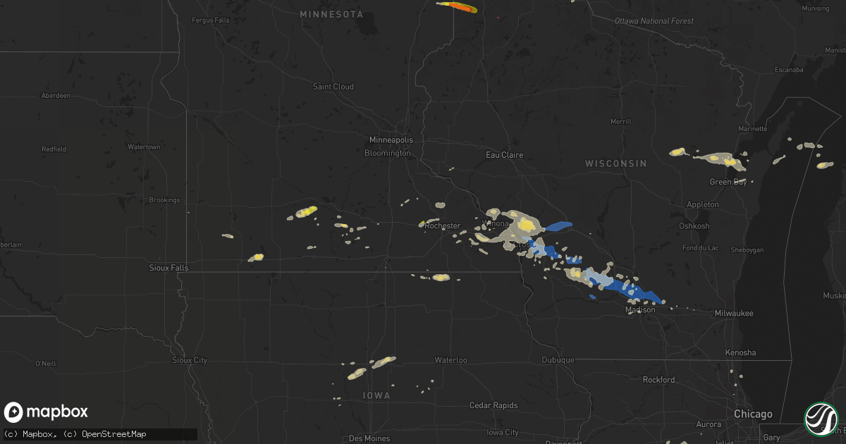
Hail Map on July 18, 2019
Get this storm
July 18 map
$229
one time, instant access
Download today. No call, no setup
Keep the $229
Bought the map and want the full workflow? Apply the entire $229 to a subscription within 7 days. None of it is wasted.
Every map, not just this one
This buys you this map. Subscription and you get every map we run, in the markets you choose from a few cities to whole states to nationwide. Plus real-time alerts the moment a storm fires.
Contact data
Name, contact info, occupancy, even credit band for addresses in the footprint. You go from where it hit to who to call.
Become the source they trust
Unlimited branding weather history reports on demand. You already have the documented answer ready for the property owner, and you are the one who showed up with it.
Property data and RoofTrace estimates
Pull up any address you have got, its value and the exact code rules for that jurisdiction, straight from One Click Code. Then RoofTrace estimates the squares, pitch, and roof value, priced the way you price.
States Impacted by Hail Map on July 18, 2019
Storm reports
Alabama
| Date | Description |
|---|---|
| 07/18/20195:50 PM CDT | Several trees down across the county. |
| 07/18/20195:08 PM CDT | Tree down near hwy 231 and cr 30 in dale county... Al. |
| 07/17/201911:59 PM CDT | At 458 PM CDT, severe thunderstorms were located along a line extending from near Ozark to near Hartford, moving northeast at 10 mph. HAZARD...60 mph wind gusts. SOURCE...Radar indicated. IMPACT...Expect damage to roofs, siding, and trees. Locations impacted include... Daleville, Dothan, Ozark, Headland, Fort Rucker, Hartford, Taylor, Midland City, Slocomb, Newton, Pinckard, Kinsey, Malvern, Rehobeth, Clayhatchee, Grimes, Newville, Napier Field, Memphis and Hunt Field. |
| 07/17/20197:30 PM CDT | One tree reported down along county road 50 and county road 51 near anderson. |
Louisiana
| Date | Description |
|---|---|
| 07/18/20191:55 PM CDT | Michoud facility em notified nws of sighted large waterspout near the bayou bienvenue lock south of the great flood barrier. Photo submitted of large waterspout taken f |
Florida
| Date | Description |
|---|---|
| 07/18/20192:58 PM CDT | Wftv relayed photo via social media of damage to a pool enclosure near lake roberts landing. Time estimated from radar. |
| 07/17/201911:57 PM CDT | At 457 PM EDT, a severe thunderstorm was located near Mount Plymouth, moving northwest at 10 mph. HAZARD...60 mph wind gusts. SOURCE...Radar indicated. IMPACT...Expect damage to roofs, siding, and trees. Locations impacted include... Apopka, Eustis, Mount Dora, Cassia and Mount Plymouth. |
| 07/17/201911:27 PM CDT | At 427 PM EDT, a severe thunderstorm was located over Wekiwa Springs State Park, or over Apopka, moving northwest at 10 mph. HAZARD...60 mph wind gusts and penny size hail. SOURCE...Radar indicated. IMPACT...Expect damage to roofs, siding, and trees. Locations impacted include... Apopka, Altamonte Springs, Longwood, Lockhart and Zellwood. |
| 07/17/201911:01 PM CDT | At 400 PM EDT, a severe thunderstorm was located over Horizon West, or near Windermere, moving north at 10 mph. HAZARD...60 mph wind gusts and penny size hail. SOURCE...Radar indicated. IMPACT...Expect damage to roofs, siding, and trees. Locations impacted include... Orlando, Apopka, Ocoee, Winter Garden and Windermere. |
Indiana
| Date | Description |
|---|---|
| 07/17/201910:01 PM CDT | At 301 PM EDT, a severe thunderstorm was located near Brookston, or 11 miles northeast of Otterbein, moving southeast at 10 mph. HAZARD...60 mph wind gusts and quarter size hail. SOURCE...Radar indicated. IMPACT...Hail damage to vehicles is expected. Expect wind damage to roofs, siding, and trees. Locations impacted include... Brookston, Chalmers and Badger Grove. This includes Interstate 65 between mile markers 185 and 190. |
Montana
| Date | Description |
|---|---|
| 07/18/20196:38 AM CDT | At 1138 PM MDT, a severe thunderstorm was located 14 miles northwest of Biddle, or 14 miles southwest of Broadus, moving east at 50 mph. HAZARD...60 mph wind gusts and quarter size hail. SOURCE...Radar indicated. IMPACT...Hail damage to vehicles is expected. Expect wind damage to roofs, siding, and trees. Locations impacted include... Belle Creek. |
| 07/18/20192:10 AM CDT | Possible tornado destroyed garage and tore rooftops off sheds. |
| 07/18/20191:44 AM CDT | Tornado briefly touched down 4 miles ne of ridgeway mt. Several buildings had metal rooftops torn off and peeled back. Several trees 1 ft diameter snapped. Survey rated |
| 07/18/201912:49 AM CDT | Several round hay bales moved 200 yards. Several tree limbs of 4 to 5 inch diameter downed several feet from tree. |
| 07/17/201911:50 PM CDT | Out building on fletcher ranch was destroyed. |
Michigan
| Date | Description |
|---|---|
| 07/18/20191:32 PM CDT | Multiple power lines downed closing all eb lanes of i-94 and one wb lane near steinbach road. Time estimated via radar. |
| 07/18/20196:27 AM CDT | Trees down. |
| 07/18/20196:14 AM CDT | Trees down reported by law enforcement. |
| 07/18/20195:50 AM CDT | Corrects previous tstm wnd dmg report from 2 se interlochen. Trees down. |
| 07/17/20199:29 PM CDT | At 229 PM EDT, a severe thunderstorm was located near Dexter, moving east at 40 mph. HAZARD...60 mph wind gusts. SOURCE...Radar indicated. IMPACT...Expect damage to roofs, siding, and trees. This severe thunderstorm will be near... Ann Arbor and Saline around 240 PM EDT. Ypsilanti and Dixboro around 250 PM EDT. Salem around 255 PM EDT.Other locations impacted by this severe thunderstorm include HudsonMills, Pittsfield Township, Whittaker, Hudson Mills Metropark,Bridgewater, Delhi Mills, Pleasant Lake and Barton Hills.People attending Ann Arbor Art Festival should seek safe shelter immediately! |
Texas
| Date | Description |
|---|---|
| 07/18/201912:13 AM CDT | At 512 PM CDT, a severe thunderstorm was located 23 miles southwest of Sanderson, moving northwest at 10 mph. HAZARD...60 mph wind gusts and quarter size hail. SOURCE...Radar indicated. IMPACT...Hail damage to vehicles is expected. Expect wind damage to roofs, siding, and trees. This severe thunderstorm will remain over mainly rural areas of east central Brewster and southwestern Terrell Counties. |
Iowa
| Date | Description |
|---|---|
| 07/18/20198:47 AM CDT | Trained spotter reported numerous instances of medium to large tree branches down while driving around town... Including estimated 12 inch diameter branches. Also repor |
| 07/18/20198:45 AM CDT | Pea hail began at 841 am and grew to nickel to quarter at 845 am. |
| 07/18/20198:45 AM CDT | Many whole trees down either snapped or uprooted along with several smaller limbs down throughout town. Some roads blocked from downed trees. Local college without powe |
| 07/18/20197:40 AM CDT | At 1240 AM CDT, a severe thunderstorm was located near Manly, or near Mason City, moving northeast at 25 mph. HAZARD...60 mph wind gusts and quarter size hail. SOURCE...Radar indicated. IMPACT...Hail damage to vehicles is expected. Expect wind damage to roofs, siding, and trees. Locations impacted include... Manly, Plymouth, Kensett, Grafton, Rock Falls and Bolan. This includes Interstate 35 near mile marker 202. |
| 07/18/20193:45 AM CDT | At 844 AM CDT, a severe thunderstorm was located near Iowa Falls, moving northeast at 40 mph. HAZARD...60 mph wind gusts and quarter size hail. SOURCE...Radar indicated. IMPACT...Hail damage to vehicles is expected. Expect wind damage to roofs, siding, and trees. Locations impacted include... Iowa Falls, Allison, Parkersburg, Ackley, Aplington, Dumont, Geneva, Bristow, Bradford, Hansell, Aredale, Owasa, Iowa Falls Municipal Airport, Allison Municipal Airport and Ackley Municipal Airport. |
Virginia
| Date | Description |
|---|---|
| 07/18/20194:42 PM CDT | Tree down on mollies creek rd blocking part of road... Near diamond hill church. |
| 07/18/20192:12 AM CDT | At 712 PM EDT, severe thunderstorms were located along a line extending from 6 miles south of Seaboard to 6 miles west of Rich Square, moving east at 15 mph. HAZARD...60 mph wind gusts and penny size hail. SOURCE...Radar indicated. IMPACT...Expect damage to trees and powerlines. Severe thunderstorms will be near, Rich Square around 735 PM EDT. Conway and Woodland around 745 PM EDT.Other locations impacted by these severe thunderstorms includeEagletown, Milwaukee, Pendleton, Potecasi, Menola, Lasker, Jackson,Bryantown, Boones Crossroads and Pleasant Grove. |
| 07/18/201912:42 AM CDT | At 542 PM EDT, a severe thunderstorm was located over Mike, moving east at 20 mph. HAZARD...60 mph wind gusts and quarter size hail. SOURCE...Radar indicated. IMPACT...Hail damage to vehicles is expected. Expect wind damage to roofs, siding, and trees. Locations impacted include... Keysville... Charlotte Court House... Phenix... Red House... and Pamplin City. |
| 07/18/201912:03 AM CDT | At 502 PM EDT, a severe thunderstorm was located over Huddleston, moving southeast at 10 mph. HAZARD...60 mph wind gusts. SOURCE...Radar indicated. IMPACT...Expect damage to roofs, siding, and trees. Locations impacted include... Altavista... Hurt... Moneta... Huddleston... and Evington. |
| 07/17/201911:54 PM CDT | At 454 PM EDT, a severe thunderstorm was located over Ararat, moving east at 30 mph. HAZARD...60 mph wind gusts. SOURCE...Radar indicated. IMPACT...Expect damage to roofs, siding, and trees. Locations impacted include... Flat Rock... Pilot Mountain... Walnut Cove... Danbury... and Francisco. |
Kentucky
| Date | Description |
|---|---|
| 07/18/20193:50 PM CDT | Several trees reported down near the intersection of ky-467 and straight shoot road. Time estimated from radar. |
| 07/17/201911:35 PM CDT | At 435 PM EDT, a severe thunderstorm was located near Crittenden, moving southeast at 15 mph. HAZARD...60 mph wind gusts. SOURCE...Radar indicated. IMPACT...Expect damage to trees and power lines. Locations impacted include... Independence, Williamstown, Walton, Falmouth, Crittenden, Butler, Goforth, Atwood, Greenwood, Grants Lick, Morning View, Northcutt, Williamstown Lake, Bracht, Gardnersville, Kincaid Lake State Park, Knoxville, White Villa, Fiskburg and Catawba.This includes I-75 in Kentucky between mile markers 164 and 172. |
North Carolina
| Date | Description |
|---|---|
| 07/18/20196:30 PM CDT | Measured at a mesonet station in conway... Nc. |
| 07/18/20196:15 PM CDT | Trained spotter reported large 8in diameter tree branch across roadway. Time estimated by radar. |
| 07/18/20196:12 PM CDT | Tree across harden rd. Radar estimated time. |
| 07/18/20196:09 PM CDT | Tree down blocking two lanes of s mebane st. |
| 07/18/20195:24 PM CDT | Tree down near hwy 158. Time estimated by radar. |
| 07/18/20195:18 PM CDT | 2 trees down near hwy 903. Time estimated by radar. |
| 07/18/20195:15 PM CDT | Tree down. Time estimated by radar. |
| 07/18/20194:00 PM CDT | Several trees down near pilot mountain. Time from radar. |
| 07/18/20192:40 PM CDT | Trees down on the 7400 block of old us highway 64. Time estimated by radar. |
| 07/18/20197:22 AM CDT | At 1222 AM EDT, a severe thunderstorm was located 9 miles northwest of Fremont, or 13 miles northeast of Smithfield, moving east at 35 mph. HAZARD...60 mph wind gusts. SOURCE...Radar indicated. IMPACT...Expect damage to roofs, siding, and trees. Locations impacted include... Smithfield, Wilson, Elm City, Fremont, Bailey, Micro, Selma, Sharpsburg, Pine Level and Kenly. |
| 07/18/20197:11 AM CDT | At 1211 AM EDT, a severe thunderstorm was located 7 miles northeast of Smithfield, moving east at 35 mph. HAZARD...60 mph wind gusts. SOURCE...Radar indicated. IMPACT...Expect damage to roofs, siding, and trees. Locations impacted include... Smithfield, Wilson, Elm City, Fremont, Bailey, Micro, Selma, Sharpsburg, Pine Level and Kenly. |
| 07/18/20194:44 AM CDT | At 943 PM EDT, severe thunderstorms were located along a line extending from 8 miles south of Bailey to 8 miles west of Fremont to 7 miles southeast of Smithfield, moving east at 20 mph. HAZARD...60 mph wind gusts. SOURCE...Radar indicated. IMPACT...Expect damage to roofs, siding, and trees. Locations impacted include... Goldsboro, Wilson, Fremont, Kenly, Princeton, Lucama, Black Creek, Pikeville, Eureka and Nahunta. |
| 07/18/20194:21 AM CDT | At 921 PM EDT, severe thunderstorms were located along a line extending from 11 miles southwest of Bailey to 6 miles southwest of Smithfield, moving east at 15 mph. HAZARD...60 mph wind gusts. SOURCE...Radar indicated. IMPACT...Expect damage to roofs, siding, and trees. Locations impacted include... Smithfield, Micro, Selma, Four Oaks, Pine Level, Kenly, Princeton and Buckhorn Reservoir. |
| 07/18/20192:17 AM CDT | At 716 PM EDT, a severe thunderstorm was located 7 miles northwest of Rockingham, moving east at 20 mph. HAZARD...60 mph wind gusts. SOURCE...Radar indicated. IMPACT...Expect damage to roofs, siding, and trees. Locations impacted include... Rockingham, Hamlet, Hoffman, Ellerbe, East Rockingham, Blewett Falls Lake, Derby and Sandhills Game Land. |
| 07/18/20191:48 AM CDT | At 648 PM EDT, a severe thunderstorm was located over Bethel, or 15 miles south of Whiteville, moving east at 20 mph. HAZARD...60 mph wind gusts and quarter size hail. SOURCE...Radar indicated. IMPACT...Minor hail damage to vehicles is possible. Expect wind damage to trees and power lines. Locations impacted include... Bethel, Freeland, Pireway, Ash, Nakina, Dulah, Old Dock, Mollie, Exum, Bughill, Longwood and Crusoe Island. |
| 07/18/20191:40 AM CDT | At 639 PM EDT, a severe thunderstorm was located near Monroeton, or 8 miles northeast of Greensboro, moving east at 25 mph. HAZARD...60 mph wind gusts. SOURCE...Radar indicated. IMPACT...Expect damage to roofs, siding, and trees. Locations impacted include... Greensboro, Burlington, Graham, McLeansville, Elon College, Gibsonville, Haw River, Alamance, Lake Guilford Mackintosh Marina and Lake Burlington. |
| 07/18/20191:13 AM CDT | At 613 PM EDT, a severe thunderstorm was located over Littleton, or 13 miles east of Warrenton, moving northeast at 20 mph. HAZARD...60 mph wind gusts. SOURCE...Radar indicated. IMPACT...Expect damage to roofs, siding, and trees. Locations impacted include... Roanoke Rapids, Halifax, Littleton, Weldon, South Weldon, Airlie, Roanoke Rapids Lake, Rosemary, Lake Gaston and Southpointe And Morningstar Marinas. |
| 07/18/201912:58 AM CDT | At 557 PM EDT, a severe thunderstorm was located near Kernersville, or 7 miles south of Walnut Cove, moving east at 25 mph. HAZARD...60 mph wind gusts. SOURCE...Radar indicated. IMPACT...Expect damage to roofs, siding, and trees. Locations impacted include... Greensboro, Winston-Salem, High Point, Kernersville, Summerfield, Stokesdale, Walkertown, Pleasant Garden, Haw River State Park and Lake Jeanette Marina. |
| 07/17/201910:35 PM CDT | At 335 PM EDT, a severe thunderstorm was located near Lexington, moving east at 15 mph. HAZARD...60 mph wind gusts. SOURCE...Radar indicated. IMPACT...Expect damage to roofs, siding, and trees. Locations impacted include... High Point, Lexington, Denton, Gordontown, Martha and High Rock Lake. |
| 07/17/20198:51 PM CDT | Trees down on power lines on vail road... South of the intersection with perkins road. |
South Carolina
| Date | Description |
|---|---|
| 07/18/20195:42 PM CDT | Report of tree down on st. Paul road. Time estimated by radar. |
| 07/18/20195:35 PM CDT | Trees down on hwy 301. Other locations with trees down in the liberty hill area also. Time estimated by radar. |
| 07/18/20195:08 PM CDT | Powerlines down on church street. Time estimated by radar. |
| 07/18/20195:01 PM CDT | Dot notified of trees down in the vicinity of guinyard street... Garnet street and redmon st. Near the city of orangeburg. |
| 07/18/20194:54 PM CDT | Tree fell through house at 734 partridge road in orangeburg county. Time estimated by radar. |
| 07/18/20194:52 PM CDT | Multiple trees down on levi pond rd in the town of neeses in orangeburg county. Time estimated by radar. |
| 07/18/20194:24 PM CDT | Em reported multiple trees down including a tree down on a car in the boulware road area. Time estimated by radar. |
| 07/18/20194:24 PM CDT | Trained spotter reported 2 structures with missing roofs or other significant roof damage... Damage to car dealership buildings and downed power lines in lugoff. Power |
| 07/18/20194:14 PM CDT | Multiple trees down on rinehart rd between poplar point rd and 500 block of rinehart rd in saluda county. Time estimated by radar. |
| 07/18/20194:12 PM CDT | Tree down on meadows lane and rinehart rd in saluda county. Time estimated by radar. |
| 07/18/20194:06 PM CDT | Tree in roadway. Time estimated by radar. Sc 23 and bethel road in saluda county. Source state highway patrol. |
| 07/18/20194:06 PM CDT | Tree in roadway. Holstein ridge road and burton drive... Saluda county. Highway patrol source. Time estimated by radar. |
| 07/18/20194:03 PM CDT | Schp reported tree in roadway us 1 at chinquapin church road. Time estimated by radar. |
| 07/18/20194:03 PM CDT | Tree down 3700 block of hwy 23. Time estimated by radar. |
| 07/18/20193:26 PM CDT | Tree down on buncomde st in western edgefield county. Time estimated by radar. |
| 07/18/20193:25 PM CDT | Reports of tree limbs down in the dutchman creek area. |
| 07/18/20193:12 PM CDT | Schp reported a tree down at clifton glendale rd and church st |
| 07/18/20193:11 PM CDT | Highway patrol reported tree down on old state road near big beaver creek road. |
| 07/18/20193:06 PM CDT | Tree in roadway in sandy run us 176 and us 21. State highway patrol source. |
| 07/18/20192:52 PM CDT | Schp reported trees and power lines down at highway 176 and petunia rd. |
| 07/18/20192:51 PM CDT | Sc highway patrol reported a tree down near intersection of church lane and sunset drive. |
| 07/18/20192:35 PM CDT | Powerline down on mcneary st in the town of prosperity in newberry county. Time estimated by radar. |
| 07/18/20192:35 PM CDT | Railroad crossing arms damaged at colony church rd in the town of prosperity in newberry county. Time estimated by radar. |
| 07/18/20192:35 PM CDT | Tree down on circle dr near citgo in the town of prosperity in newberry county. Time estimated by radar. |
| 07/18/20192:35 PM CDT | Powerlines down on highway 76 near wightman church in the town of prosperity in newberry county. Time estimated by radar. |
| 07/18/20192:35 PM CDT | Tree down on highway 76 in front of mckechnie vehicle components in the town of prosperity in newberry county. Time estimated by radar. |
| 07/18/20192:35 PM CDT | Tree down on grace st in the town of prosperity in newberry county. Time estimated by radar. |
| 07/18/20192:35 PM CDT | Damage to baseball field on s. Wheeler ave at highway 76 in the town of prosperity in newberry county. Time estimated by radar. |
| 07/18/20192:15 PM CDT | Schp reported a tree down at 4200 jug factory rd |
| 07/18/20191:00 PM CDT | *** 2 fatal... 2 inj *** portion of home under contruction collapsed. |
| 07/18/201912:52 PM CDT | *** 2 fatal... 2 inj *** report of several trees and powerlines down... As well as structural damage to a home that was under construction and collapsed. Time estimated |
| 07/18/20191:50 AM CDT | At 649 PM EDT, severe thunderstorms were located along a line extending from 10 miles west of Kingstree to 18 miles northeast of Indian Field, moving southeast at 35 mph. HAZARD...60 mph wind gusts and penny size hail. SOURCE...Radar indicated. IMPACT...Expect damage to trees and powerlines. Locations impacted include... Moncks Corner, St. Stephen, Bonneau, Southern Lake Moultrie, Eadytown, Cross, Northern Lake Moultrie and Bonneau Beach. |
| 07/18/20191:37 AM CDT | At 637 PM EDT, a severe thunderstorm was located near Hebron, or 9 miles northwest of Kingstree, moving east at 20 mph. HAZARD...60 mph wind gusts and quarter size hail. SOURCE...Radar indicated. IMPACT...Minor hail damage to vehicles is possible. Expect wind damage to trees and power lines. Locations impacted include... Lake City, Kingstree, Trio, Salters, Hebron, Cades, Gourdin, Lane, Greeleyville and Williamsburg Regional Hospital. |
| 07/18/20191:37 AM CDT | At 637 PM EDT, a severe thunderstorm was located over Summerton, or 12 miles southwest of Manning, moving southeast at 25 mph. HAZARD...60 mph wind gusts. SOURCE...Law enforcement reported trees down. This storm has a history of producing strong damaging winds. IMPACT...Expect damage to roofs, siding, and trees. Locations impacted include... Summerton, Santee State Park, Santee Cooper Regional Airport, Eautaw Springs, Poplar Creek Landing, St. Paul, Davis Station, Rocks Pond Campground and Marina and Blounts Landing.This includes Interstate 95 between mile markers 100 and 113. |
| 07/18/20191:28 AM CDT | At 628 PM EDT, a severe thunderstorm was located over Manning, moving southeast at 30 mph. HAZARD...60 mph wind gusts. SOURCE...Radar indicated. IMPACT...Expect damage to roofs, siding, and trees. Locations impacted include... Manning, Santee Cooper Regional Airport and Foreston. This includes Interstate 95 between mile markers 114 and 122. |
| 07/18/20191:25 AM CDT | At 624 PM EDT, a severe thunderstorm was located 7 miles west of Elloree, or 7 miles east of Brookdale, moving southeast at 40 mph. HAZARD...70 mph wind gusts and quarter size hail. SOURCE...Law enforcement reports trees down across portions of central Orangeburg County. This storm has a history of producing strong damaging winds. IMPACT...Hail damage to vehicles is expected. Expect considerable tree damage. Wind damage is also likely to mobile homes, roofs, and outbuildings. Locations impacted include... Brookdale, Holly Hill, Bowman, Elloree, Santee, Cameron, Eutawville, Vance, Yonder Field, Eautaw Springs, Indian Bluff Recreation Park, Creston, Mill Creek Marina and Campground and Wilkinson Heights.This includes the following highways... Interstate 26 between mile markers 147 and 168. Interstate 95 between mile markers 86 and 99. |
| 07/18/201912:58 AM CDT | At 558 PM EDT, a severe thunderstorm was located near Santee State Park, or 16 miles west of Manning, moving southeast at 35 mph. HAZARD...60 mph wind gusts and nickel size hail. SOURCE...Radar indicated. IMPACT...Expect damage to roofs, siding, and trees. Locations impacted include... Summerton, Santee State Park, Santee Cooper Regional Airport, Santee, Pinewood, Eutawville, Vance, Poplar Creek Landing, Rimini, St. Paul, Stumphole Landing, Rocks Pond Campground and Marina, Eautaw Springs, Indian Bluff Recreation Park, Davis Station, Blounts Landing, Mill Creek Marina and Campground, Lone Star and Low Falls Landing.This includes Interstate 95 between mile markers 97 and 112. |
| 07/18/201912:48 AM CDT | At 547 PM EDT, a severe thunderstorm was located over Orangeburg, moving southeast at 40 mph. HAZARD...60 mph wind gusts. SOURCE...Radar indicated. IMPACT...Expect damage to roofs, siding, and trees. Locations impacted include... Orangeburg, Brookdale, St. Matthews, Bowman, Elloree, Orangeburg County Airport, Claflin College, Edisto Gardens, South Carolina State University, Santee, Cameron, Rowesville, Cordova, Yonder Field, Wilkinson Heights, Prince of Orange Mall and Edisto.This includes the following highways... Interstate 26 between mile markers 138 and 166. Interstate 95 between mile markers 94 and 97. |
| 07/18/201912:12 AM CDT | At 511 PM EDT, a severe thunderstorm was located 8 miles east of Saluda, or 10 miles northwest of Batesburg-Leesville, moving east at 30 mph. HAZARD...60 mph wind gusts. SOURCE...Radar indicated. IMPACT...Expect damage to roofs, siding, and trees. Locations impacted include... Dreher Island State Park, Summit, Cedar Grove Fire Station, South Shore Marina, Oswald Park, Murray, Hollywood Elementary School, Emory, Lake Murray Shores, Circle Fire Station, Delmar, Hollow Creek Public Park and Riverbend Boat Ramp. |
| 07/18/201912:03 AM CDT | At 503 PM EDT, a severe thunderstorm was located over Longtown, or 7 miles west of Lake Wateree Dam, moving southeast at 20 mph. HAZARD...60 mph wind gusts. SOURCE...Radar indicated. IMPACT...Expect damage to roofs, siding, and trees. Locations impacted include... Camden, Lake Wateree Dam, Lugoff, Longtown, Ridgeway, Pine Grove Fire Station, North Towne Square Shopping Center and Woodward Airfield.This includes Interstate 20 in South Carolina between mile markers 87and 97. |
| 07/18/201912:00 AM CDT | At 500 PM EDT, a severe thunderstorm was located near Batesburg-Leesville, moving east at 40 mph. HAZARD...60 mph wind gusts. SOURCE...Radar indicated. IMPACT...Expect damage to roofs, siding, and trees. Locations impacted include... Batesburg-Leesville, Red Bank, Ridge Spring, Saluda County Airport, Gilbert, Summit, Monetta, Ward, Fredonia, Murray, Camp Kinard, Emory, Hibernia, Steedman, Kneece, Samaria Fire Station, Cedar Pond Campground and Saluda Co Sheriff's Office.This includes Interstate 20 in South Carolina between mile markers 31and 53. |
| 07/17/201911:24 PM CDT | At 424 PM EDT, a severe thunderstorm was located 9 miles northwest of Union, or 4 miles southwest of Jonesville, moving southeast at 10 mph. HAZARD...60 mph wind gusts and penny size hail. SOURCE...Radar indicated. IMPACT...Expect damage to trees and power lines. Locations impacted include... Buffalo, Jonesville and Union. |
| 07/17/201911:08 PM CDT | At 408 PM EDT, a severe thunderstorm was located near Mistletoe State Park, or 11 miles north of Thomson, moving east at 30 mph. HAZARD...70 mph wind gusts and quarter size hail. SOURCE...Radar indicated. IMPACT...Hail damage to vehicles is expected. Expect considerable tree damage. Wind damage is also likely to mobile homes, roofs, and outbuildings. Locations impacted include... Grovetown, Evans, Martinez, Appling, Clarks Hill Recreation Area, J. Strom Thurmond Dam, Riverwood, Mistletoe State Park, Thomson-McDuffie County Airport, Wrightsboro, Winfield, Scott's Landing, White Oak Campground, Columbia County Jail, Blanchard Park, Wildwood Park, Ansley Mill, Eubank-Blanchard Community Center, Westmont and Bussey Point Campground.This includes Interstate 20 in Georgia between mile markers 172 and193. |
| 07/17/201911:04 PM CDT | At 404 PM EDT, a severe thunderstorm was located over Sandy Run, or 12 miles southeast of Cayce, moving east at 30 mph. HAZARD...60 mph wind gusts. SOURCE...Radar indicated. IMPACT...Expect damage to roofs, siding, and trees. Locations impacted include... St. Matthews, Gadsden, Congaree National Park, Sandy Run, Cameron, New Zion and Fort Motte.This includes Interstate 26 between mile markers 121 and 140. |
| 07/17/201911:02 PM CDT | At 402 PM EDT, severe thunderstorms were located along a line extending from 9 miles southwest of Ninety Six Historic Site to near J. Strom Thurmond Dam, moving east at 25 mph. HAZARD...70 mph wind gusts. SOURCE...Radar indicated. IMPACT...Expect considerable tree damage. Damage is likely to mobile homes, roofs, and outbuildings. Locations impacted include... North Augusta, Augusta, Clearwater, Belvedere, Martinez, Edgefield, Saluda, Johnston, Clarks Hill Recreation Area, Edgefield County Airport, Hamilton Branch State Park, Augusta National Golf Club, Saluda County Airport, J. Strom Thurmond Dam, Burnettown, Trenton, Parksville, Plum Branch, West End Augusta and Saluda Co Sheriff's Office.This includes the following highways... Interstate 20 in Georgia between mile markers 199 and 201. Interstate 20 in South Carolina between mile markers 0 and 11. Interstate 520 in Georgia between mile markers 14 and 15. Interstate 520 in South Carolina between mile markers 16 and 23. |
| 07/17/201910:59 PM CDT | At 358 PM EDT, a severe thunderstorm was located over Dreher Island State Park, or 11 miles northwest of Lake Murray Dam, moving southeast at 25 mph. HAZARD...70 mph wind gusts and quarter size hail. SOURCE...Emergency management multiple trees down across Newberry County near the Prosperity area. IMPACT...Hail damage to vehicles is expected. Expect considerable tree damage. Wind damage is also likely to mobile homes, roofs, and outbuildings. Locations impacted include... Lexington, Irmo, Lake Murray Dam, Prosperity, Jenkinsville, Ballentine, Dreher Island State Park, Chapin, Little Mountain, Pomaria, Peak, South Shore Marina, Oswald Park, Bundrick Island, Putnam's Landing, White Rock, Rocky Point Recreation Area, Hollow Creek Public Park, Melvin Park and Lighthouse Marina.This includes Interstate 26 between mile markers 82 and 101. |
| 07/17/201910:50 PM CDT | At 348 PM EDT, a severe thunderstorm was located just northwest of Lake Wateree, moving east-southeast at 20 mph. HAZARD...60 mph wind gusts and quarter size hail. SOURCE...Radar indicated. IMPACT...Hail damage to vehicles is expected. Expect wind damage to roofs, siding, and trees. Locations impacted include... Lake Wateree, Camden, Lake Wateree Dam, Westville, Longtown, Liberty Hill, Goodale State Park, Lake Wateree State Park, North Central High School, Dekalb, North Towne Square Shopping Center, Midway Elementary School, Woodward Airfield and Lake Wateree near Highway 97.This includes Interstate 20 in South Carolina between mile markers 99and 101. |
| 07/17/201910:49 PM CDT | At 349 PM EDT, a severe thunderstorm was located over Lake Wateree State Park, or 10 miles northwest of Lake Wateree Dam, moving east at 20 mph. HAZARD...60 mph wind gusts. SOURCE...Radar indicated. IMPACT...Expect damage to roofs, siding, and trees. Locations impacted include... Lake Wateree Dam, Kershaw, Westville, Liberty Hill, Lake Wateree State Park, Longtown, Dekalb and Lake Wateree near Highway 97. |
| 07/17/201910:43 PM CDT | At 342 PM EDT, a severe thunderstorm was located 9 miles northwest of Spartanburg, or near Inman, moving southeast at 15 mph. HAZARD...60 mph wind gusts. SOURCE...Radar indicated. IMPACT...Expect damage to trees and power lines. Locations impacted include... Spartanburg, Boiling Springs SC, Lyman, Wellford, Inman, Roebuck, Lake Bowen, USC Upstate, Cowpens and Duncan. |
| 07/17/201910:27 PM CDT | At 327 PM EDT, a severe thunderstorm was located over Prosperity, or near Newberry, moving east at 35 mph. HAZARD...60 mph wind gusts and nickel size hail. SOURCE...Radar indicated. IMPACT...Expect damage to roofs, siding, and trees. Locations impacted include... Newberry, Prosperity, Newberry College, Dreher Island State Park, Chapin, Little Mountain, Pomaria, Silverstreet, Peak, Cedar Grove Fire Station, South Shore Marina, Oswald Park, Putnam's Landing, White Rock, Rocky Point Recreation Area, Hollow Creek Public Park, Melvin Park, Lighthouse Marina, Stoney Hill and Shull Island.This includes Interstate 26 between mile markers 76 and 96. |
| 07/17/201910:22 PM CDT | At 322 PM EDT, a severe thunderstorm was located over Lincolnton, or 12 miles east of Washington, moving east at 25 mph. HAZARD...60 mph wind gusts and penny size hail. SOURCE...Radar indicated. IMPACT...Expect damage to roofs, siding, and trees. Locations impacted include... McCormick, Lincolnton, Mccormick County Airport, Hamilton Branch State Park, Elijah Clark State Park, Parksville, Plum Branch, Hickory Knob State Resort Park, Loce, Baker Creek State Park, Modoc, Knox Scout Reservation, Woodlawn, Modoc Campground, Double Branches, Curry Hill, Modoc Boat Ramp, Hawe Creek Campground, New Hope and Long Cane Creek Picnic Area. |
| 07/17/201910:12 PM CDT | At 312 PM EDT, a severe thunderstorm was located 6 miles southeast of Columbus, or near Landrum, moving southeast at 10 mph. HAZARD...60 mph wind gusts and penny size hail. SOURCE...Radar indicated. IMPACT...Expect damage to trees and power lines. Locations impacted include... Columbus, Landrum, Inman, Tryon, Campobello, Lake Bowen, Gowensville, Green Creek, Fingerville and Mill Spring. |
| 07/17/201910:03 PM CDT | At 302 PM EDT, a severe thunderstorm was located 14 miles north of Greenville Downtown, or over Tigerville, moving southeast at 15 mph. HAZARD...60 mph wind gusts. SOURCE...Radar indicated. IMPACT...Expect damage to trees and power lines. Locations impacted include... Greer, Taylors, Inman, Tigerville, Lake Robinson, Gowensville, Glassy Mountain, Campobello, Paris Mountain State Park and Slater-Marietta. |
Georgia
| Date | Description |
|---|---|
| 07/18/20196:30 PM CDT | Tree down on 1st kolomoki road between sawyer road and marys lane. |
| 07/18/20196:23 PM CDT | The bulloch county 911 center reported a tree down on stilson leefield road. Time is estimated by radar data. |
| 07/18/20196:20 PM CDT | A broadcast media relayed a report of hail in brooklet. Time is estimated by radar. |
| 07/18/20196:15 PM CDT | A broadcast media relayed a report of hail in brooklet. Time is estimated by radar. |
| 07/18/20196:04 PM CDT | A tree was reported down on hwy 251 and hwy 57. Time is estimated by radar data. |
| 07/18/20196:01 PM CDT | A tree was reported down on sinkhole road between g w oliver road and hwy 46. Time is estimated by radar. |
| 07/18/20195:21 PM CDT | Damage to the porches of a few residences along williams and price rd. Also at least one powerline down and at least one tree down along this road. |
| 07/18/20195:21 PM CDT | Minor damage to a few residences along price williams rd |
| 07/18/20195:20 PM CDT | Power lines down on gillianville rd in albany... Ga. |
| 07/18/20194:55 PM CDT | Powerline down and 6 trees down in lee county... Ga. Most of this damage is along hwy 82. |
| 07/18/20194:50 PM CDT | *** 6 inj *** the military police relayed a report that a tent was blown over during a training exercise resulting in six minor injuries. It occurred near evans army ai |
| 07/18/20194:35 PM CDT | 3 trees down near parrott... Ga. |
| 07/18/20193:25 PM CDT | Gdot reported tree down on i-16 eastbound at the mlk jr. Blvd. Exit |
| 07/18/20193:18 PM CDT | Tree reported down in mistletoe state park. Time estimated by radar. |
| 07/18/20192:31 PM CDT | Powerline down on thompson highway in lincoln county. Time estimated by radar. |
| 07/18/20192:24 PM CDT | Tree down with structual damage near the intersection of phillips rd. And phillips ct. In lithonia |
| 07/18/20192:16 PM CDT | Tree limb down... Taking down powerlines in downtown lincolnton in lincoln county. Time estimated by radar. |
| 07/18/20192:12 PM CDT | Trees and power lines down in lincolnton. |
| 07/18/201912:55 PM CDT | Large oak tree down across e gordon rd... Blocking roadway. |
| 07/18/201910:50 AM CDT | *** 1 inj *** multiple trees were downed in the town of helen. 4 trees fell across the chattahoochee river where a child recieved a minor injury while tubing. A tree wa |
| 07/18/20193:35 AM CDT | At 835 PM EDT, a severe thunderstorm was located near Waynesville, or 12 miles east of Nahunta, moving east at 5 mph. HAZARD...60 mph wind gusts and quarter size hail. SOURCE...Radar indicated. IMPACT...Hail damage to vehicles is expected. Expect wind damage to roofs, siding, and trees. Locations impacted include... Waverly, Waynesville and Atkinson. |
| 07/18/20192:24 AM CDT | At 724 PM EDT, a severe thunderstorm was located 7 miles north of Blakely, moving east at 35 mph. HAZARD...60 mph wind gusts. SOURCE...Radar indicated. IMPACT...Expect damage to roofs, siding, and trees. Locations impacted include... Fort Gaines, Morgan, Blakely, Edison, Arlington, Bellville, Bluffton, Parksville, Carnegie, Pecan, Aycock Mill, Early Co A/p, Jones Crossing, Martins Crossroads, Suttons Corner, Fort Gaines-Clay Airport, Harrisons Mill, Zetto, Moye and Cordrays Mill. |
| 07/18/20192:17 AM CDT | At 716 PM EDT, a severe thunderstorm was located 11 miles east of Statesboro, moving east at 30 mph. HAZARD...60 mph wind gusts and quarter size hail. SOURCE...Radar indicated. IMPACT...Minor hail damage to vehicles is possible. Expect wind damage to trees and powerlines. Locations impacted include... Statesboro, Guyton, Brooklet, Oliver, Pineora, Egypt, Shawnee and Leefield. |
| 07/18/20191:55 AM CDT | At 655 PM EDT, a severe thunderstorm was located over Metter, and is nearly stationary. HAZARD...60 mph wind gusts. SOURCE...Radar indicated. IMPACT...Expect damage to trees and powerlines. Locations impacted include... Statesboro, Metter, Westside, Portal, Pulaski, Register, Aline and Georgia Southern.This warning includes I-16 between mile markers 100 and 120. |
| 07/18/20191:45 AM CDT | At 645 PM EDT, a severe thunderstorm was located over Blundale, or 12 miles north of Swainsboro, moving northeast at 20 mph. HAZARD...60 mph wind gusts and penny size hail. SOURCE...Radar indicated. IMPACT...Expect damage to roofs, siding, and trees. Locations impacted include... Wadley, Summertown, Blundale, Three Points and Colemans Lake. |
| 07/18/20191:39 AM CDT | At 638 PM EDT, a severe thunderstorm was located near Tibet, moving east at 10 mph. HAZARD...60 mph wind gusts. SOURCE...Radar indicated. IMPACT...Expect damage to roofs, siding, and trees. Locations impacted include... Mount Pleasant. |
| 07/18/20191:29 AM CDT | At 629 PM EDT, a severe thunderstorm was located near Tibet, moving east at 10 mph. HAZARD...60 mph wind gusts and quarter size hail. SOURCE...Radar indicated. IMPACT...Minor hail damage to vehicles is possible. Expect wind damage to trees and powerlines. Locations impacted include... Tibet, Jones, Eulonia and Townsend. This warning includes I-95 in Georgia between mile markers 58 and 63. |
| 07/18/20191:18 AM CDT | At 618 PM EDT, a severe thunderstorm was located over Kite, or 10 miles northwest of Swainsboro, moving east at 15 mph. HAZARD...60 mph wind gusts and quarter size hail. SOURCE...Radar indicated. IMPACT...Hail damage to vehicles is expected. Expect wind damage to roofs, siding, and trees. Locations impacted include... Swainsboro, Adrian, Summertown, Kite, Norristown Junction, Dellwood, Modoc, Meeks and Blundale. |
| 07/18/201912:45 AM CDT | At 545 PM EDT, a severe thunderstorm was located 7 miles southwest of Leesburg, moving southeast at 35 mph. HAZARD...60 mph wind gusts and nickel size hail. SOURCE...Radar indicated. IMPACT...Expect damage to roofs, siding, and trees. Locations impacted include... Leesburg, Albany, Putney, East Albany, Marine Corps Logistics Base, Turner City, Walker, Warwick, Sasser, Stocks, Radium Springs, Forrester, Lockett Crossing, South Albany, Southwest Ga Regional A/P, Palmyra, Red Rock, Acree, Crestwood and Neyami. |
| 07/18/201912:26 AM CDT | At 526 PM CDT, severe thunderstorms were located along a line extending from 8 miles west of Abbeville to near Dothan, moving northeast at 15 mph. HAZARD...60 mph wind gusts. SOURCE...Radar indicated. IMPACT...Expect damage to roofs, siding, and trees. Locations impacted include... Abbeville, Headland, Dothan, Kinsey, Ashford, Cowarts, Webb, Columbia, Avon, Newville, Haleburg, Shorterville, Tumbleton, Kirkland Crossroads, Sigma, Grandberry Crossroads, Enon, Hayes, Barber and Graball. |
| 07/18/201912:23 AM CDT | At 522 PM EDT, a severe thunderstorm was located over Lundberg, or near Washington, moving southeast at 10 mph. HAZARD...60 mph wind gusts and penny size hail. SOURCE...Radar indicated. IMPACT...Expect damage to roofs, siding, and trees. Locations impacted include... Washington, Crawfordville, Sharon, Aonia, Ficklin, Lundberg, Rocky Creek Fire Dept., Raytown, Sandy Cross, Metasville, Holliday Park and Floral Hill. |
| 07/18/201912:15 AM CDT | At 515 PM EDT, severe thunderstorms were located along a line extending from near Cuthbert to 6 miles northwest of Leesburg, moving south at 25 mph. HAZARD...60 mph wind gusts and quarter size hail. SOURCE...Radar indicated. IMPACT...Hail damage to vehicles is expected. Expect wind damage to roofs, siding, and trees. Locations impacted include... Morgan, Albany, Dawson, Leesburg, Cuthbert, Edison, Shellman, Sasser, Bronwood, Bluffton, Parksville, Carnegie, Dawson Municipal A/P, Neyami, Suttons Corner, Springvale, Chickasawhatchee, Wades, Peterson Hill and Herod. |
Ohio
| Date | Description |
|---|---|
| 07/18/20194:31 PM CDT | Numerous trees down near the intersection of us224 and sr60. Delayed report from july 18 storms. |
| 07/18/20194:25 PM CDT | Several trees down and power lines down along converse chapel and converse huff roads... West of route 42. |
| 07/18/20194:15 PM CDT | A pole was snapped in a field. Also small branches were reported over a road in the plain city area. |
| 07/18/20193:20 PM CDT | Lines and wires were blown down from contact with trees. |
| 07/18/20193:15 PM CDT | A local report indicates 59 MPH wind near KHAO HAMILTON APT |
| 07/18/20192:55 PM CDT | One tree reported down near the intersection of oh-66 and cardo road. Time estimated from radar. |
| 07/18/20192:11 PM CDT | Tree limbs downed. |
| 07/18/20191:30 PM CDT | Updates previous tstm wnd dmg report from 3 wsw van wert. 8 trees down aprrox 80 ft tall. A few were snapped half way up. Lots of limbs on ground. All trees fell to the |
| 07/17/201910:48 PM CDT | At 348 PM EDT, a severe thunderstorm was located over Newport, moving southeast at 30 mph. HAZARD...60 mph wind gusts. SOURCE...Radar indicated. IMPACT...Expect damage to trees and power lines. Locations impacted include... Sidney, Piqua, Minster, Versailles, Covington, Newport, Bradford, Fort Loramie, Pleasant Hill, Hardin, Webster, Russia, Osgood, North Star, Lockington, Yorkshire, Polo, Newbern, Egypt and Willowdell.This includes I-75 in Ohio between mile markers 79 and 92. |
| 07/17/201910:14 PM CDT | At 314 PM EDT, severe thunderstorms were located along a line extending from Holland to near Weston, moving east at 35 mph. HAZARD...60 mph wind gusts and penny size hail. SOURCE...Radar indicated. IMPACT...Expect damage to trees and power lines. Locations impacted include... Bowling Green, Fremont, Perrysburg, Oregon, Rossford, Waterville, Northwood, Whitehouse, Oak Harbor, Gibsonburg, Genoa, Woodville, Holland, Weston, Elmore, Maumee, Ballville, Walbridge, Pemberville and Millbury. |
North Dakota
| Date | Description |
|---|---|
| 07/17/201910:40 PM CDT | At 340 AM CDT, a severe thunderstorm was located 5 miles southeast of Braddock, or 12 miles west of Napoleon, moving east at 45 mph. HAZARD...70 mph wind gusts and half dollar size hail. SOURCE...Radar indicated. IMPACT...Hail damage to vehicles is expected. Expect considerable tree damage. Wind damage is also likely to mobile homes, roofs, and outbuildings. This severe thunderstorm will be near... Napoleon around 355 AM CDT. Gackle around 440 AM CDT.Other locations impacted by this severe thunderstorm includeBurnstad, Kintyre, Beaver Lake State Park and Fredonia. |
| 07/17/20199:02 PM CDT | At 202 AM CDT, a severe thunderstorm was located near Prairie Knights Resort, or 9 miles north of Fort Yates, moving east at 30 mph. HAZARD...60 mph wind gusts and half dollar size hail. SOURCE...Radar indicated. IMPACT...Hail damage to vehicles is expected. Expect wind damage to roofs, siding, and trees. This severe thunderstorm will be near... Linton around 235 AM CDT. Strasburg around 240 AM CDT.Other locations impacted by this severe thunderstorm include BeaverBay Recreation Area. |
Wisconsin
| Date | Description |
|---|---|
| 07/18/20192:33 PM CDT | Relayed through douglas co. Sheriffs dept. Time estimated from radar. |
| 07/18/201912:00 PM CDT | Fire department observed relayed through douglas co. Dispatch. |
| 07/18/201911:37 AM CDT | A local report indicates 60 MPH wind near 1 N TOMAH |
| 07/18/20197:08 AM CDT | At 1208 PM CDT, a severe thunderstorm was located 7 miles southeast of Foxboro, or 20 miles south of Superior, moving east at 30 mph. HAZARD...Two inch hail and 60 mph wind gusts. SOURCE...Radar indicated. IMPACT...People and animals outdoors will be injured. Expect hail damage to roofs, siding, windows, and vehicles. Expect wind damage to roofs, siding, and trees. Locations impacted include... Solon Springs, Gordon, Bennett, Chaffey, Amnicon Lake, Lyman Lake, and Saint Croix Flowage. |
| 07/18/20196:51 AM CDT | At 1151 AM CDT, a severe thunderstorm was located over Holyoke, or 20 miles south of Cloquet, moving east at 30 mph. HAZARD...Golf ball size hail and 60 mph wind gusts. SOURCE...Radar indicated. IMPACT...People and animals outdoors will be injured. Expect hail damage to roofs, siding, windows, and vehicles. Expect wind damage to roofs, siding, and trees. Locations impacted include... Holyoke, Foxboro, Chaffey, Harlis, Patzau, Moose Junction, Amnicon Lake, Lyman Lake, and Belden. |
| 07/18/20196:32 AM CDT | At 1131 PM CDT, a severe thunderstorm was located near Fort Mc Coy, or near Tomah, moving east at 45 mph. HAZARD...60 mph wind gusts. SOURCE...Radar indicated. IMPACT...Expect damage to roofs, siding, and trees. This severe thunderstorm will be near... Tomah around 1135 PM CDT.Other locations impacted by this severe thunderstorm include Warrens, Jackson Pass, Normay Ridge, Oakdale, and Tunnel City. |
| 07/18/20196:12 AM CDT | At 1112 PM CDT, a severe thunderstorm was located near Bangor, or 10 miles southwest of Sparta, moving east at 20 mph. HAZARD...60 mph wind gusts and penny size hail. SOURCE...Radar indicated. IMPACT...Expect damage to roofs, siding, and trees. This severe thunderstorm will be near... Cashton around 1145 PM CDT.Other locations impacted by this severe thunderstorm include Brinkman Ridge, Jersey Valley County Park, Irish Hill, Portland, Esofea and Goose Island. |
| 07/18/20191:45 AM CDT | Wires down west of lodi. Time estimated from radar. |
| 07/18/20191:30 AM CDT | A few trees down in spring green. Time estimated from radar. |
| 07/18/20191:25 AM CDT | Tree damage and yard items scattered. Some tree tops broken off. Time estimated from radar. |
| 07/18/20191:01 AM CDT | A few trees down in la valle. Time estimated from radar. |
| 07/18/201912:55 AM CDT | About 10 trees down... Mainly in western parts of sauk county. |
| 07/17/201911:42 PM CDT | Brief tornado damaged farm buildings along wang ridge road... In addition to trees. May have lasted for 1-2 min. Est. Ef0 |
| 07/17/201911:37 PM CDT | A local report indicates 60 MPH wind near 1 N TOMAH |
| 07/17/201911:35 PM CDT | Sporadic wind damage noted along highway 333 from near cashton to middle ridge. Time estimated from radar. |
| 07/17/201911:00 PM CDT | Report of trees down blocking north bound lane on yy. Time estimated based on radar. |
| 07/17/201910:55 PM CDT | A local report indicates 60 MPH wind near 1 NNE MINDORO |
| 07/17/201910:50 PM CDT | At 348 AM CDT, severe thunderstorms were located along a line extending from near Muscoda to near Lancaster, moving southeast at 50 mph. HAZARD...60 mph wind gusts and quarter size hail. SOURCE...Law enforcement. Quarter size hail was reported in Woodman at 345 AM. IMPACT...Hail damage to vehicles is expected. Expect wind damage to roofs, siding, and trees. Severe thunderstorms will be near... Muscoda around 355 AM CDT. Platteville around 410 AM CDT. Cuba City around 415 AM CDT.Other locations impacted by these severe thunderstorms includePreston, Arthur, Highway 61 And County T, Montfort, Mount Ida,Beetown and Union. |
South Dakota
| Date | Description |
|---|---|
| 07/18/20195:15 PM CDT | A local report indicates a tornado near 2 NW CROOKS |
| 07/18/20197:55 AM CDT | At 1254 AM MDT, a severe thunderstorm was located near Wanblee, or 18 miles south of Kadoka, moving east at 40 mph. HAZARD...Quarter size hail. SOURCE...Radar indicated. IMPACT...Damage to vehicles is expected. Locations impacted include... Wanblee. |
| 07/18/20197:51 AM CDT | At 1251 AM CDT, a severe thunderstorm was located over Aberdeen, moving northeast at 55 mph. HAZARD...60 mph wind gusts. SOURCE...Radar indicated. IMPACT...Expect damage to roofs, siding, and trees. Locations impacted include... Aberdeen, Groton, Bath, Warner, Columbia and Putney. |
| 07/18/20197:05 AM CDT | At 1204 AM MDT, a severe thunderstorm was located 6 miles north of Kyle, or 33 miles northwest of Martin, moving east at 25 mph. HAZARD...Quarter size hail. SOURCE...Radar indicated. IMPACT...Damage to vehicles is expected. Locations impacted include... Potato Creek. |
| 07/18/20196:52 AM CDT | 2 grain bins blown off their bases... 2 others damaged. Photo via social media. Radar estimated time. |
| 07/18/20196:42 AM CDT | Time estimated via radar. |
| 07/18/20196:04 AM CDT | A local report indicates 64 MPH wind near 1 NE RIDGEVIEW |
| 07/18/20195:38 AM CDT | Time estimated by radar. |
| 07/18/20195:22 AM CDT | Mesonet station lans2 lantry 3 nw. Time estimated by radar. |
| 07/18/20194:45 AM CDT | Strong winds... No damage |
| 07/18/20194:08 AM CDT | Lots of small tree limbs down and some very large dead tree limbs. Radar estimated time. Corrects previous lsr for time. |
| 07/18/20193:45 AM CDT | A local report indicates 60 MPH wind near 1 SW SHADEHILL |
| 07/18/20193:08 AM CDT | Lots of small tree limbs down and some very large dead tree limbs. Radar estimated time. |
| 07/18/20192:50 AM CDT | A parked semi tipped over... And an awning was broken off a camper. |
| 07/18/20192:30 AM CDT | Branches off trees... Tin corner lifted off of shed |
| 07/18/20192:30 AM CDT | Branches off trees... Tin corner lifted off of shed |
Minnesota
| Date | Description |
|---|---|
| 07/18/20195:00 AM CDT | At 1000 PM CDT, a severe thunderstorm was located over Good Thunder, or 10 miles south of Mankato, moving east at 20 mph. HAZARD...Ping pong ball size hail and 60 mph wind gusts. SOURCE...Radar indicated. IMPACT...People and animals outdoors will be injured. Expect hail damage to roofs, siding, windows, and vehicles. Expect wind damage to roofs, siding, and trees. This severe thunderstorm will be near... Mapleton around 1015 PM CDT. St. Clair around 1030 PM CDT. Pemberton around 1040 PM CDT. |
| 07/18/20192:32 AM CDT | At 732 PM CDT, a severe thunderstorm was located near Comfrey, or 19 miles southwest of New Ulm, moving east at 35 mph. HAZARD...60 mph wind gusts and nickel size hail. SOURCE...Radar indicated. IMPACT...Expect damage to roofs, siding, and trees. This severe thunderstorm will be near... Hanska around 755 PM CDT. New Ulm around 800 PM CDT.Other locations impacted by this severe thunderstorm includeSveadahl, New Ulm Airport, Darfur, Searles and La Salle.This includes U.S. Highway 14 between mile markers 97 and 103. |
| 07/18/20192:19 AM CDT | At 719 PM CDT, a severe thunderstorm was located over Nerstrand, or 11 miles southeast of Northfield, moving northeast at 40 mph. HAZARD...60 mph wind gusts and half dollar size hail. SOURCE...Radar indicated. IMPACT...Hail damage to vehicles is expected. Expect wind damage to roofs, siding, and trees. This severe thunderstorm will be near... Stanton around 730 PM CDT. Cannon Falls around 740 PM CDT.Other locations impacted by this severe thunderstorm include Wastedo,Hader, Lake Byllesby and Bombay. |
| 07/18/201912:59 AM CDT | At 558 PM CDT, a severe thunderstorm was located near Mapleton, or 21 miles south of Mankato, moving northeast at 25 mph. HAZARD...60 mph wind gusts and quarter size hail. SOURCE...Radar indicated. IMPACT...Hail damage to vehicles is expected. Expect wind damage to roofs, siding, and trees. Locations impacted include... Mapleton, Minnesota Lake, Pemberton and Waldorf. |
| 07/17/201911:50 PM CDT | At 449 AM CDT, a severe thunderstorm was located near Lake Hassel, or 24 miles southeast of Morris, moving east at 45 mph. HAZARD...Ping pong ball size hail. SOURCE...Radar indicated. IMPACT...People and animals outdoors will be injured. Expect damage to roofs, siding, windows, and vehicles. Locations impacted include... Lake Hassel, Norway Lake, Gilchrist, Sunburg and Swift Falls. |
| 07/17/201911:28 PM CDT | At 427 AM CDT, a severe thunderstorm was located over Savage, or 16 miles south of Minneapolis, moving northeast at 45 mph. HAZARD...Quarter size hail. SOURCE...Trained weather spotters. IMPACT...Damage to vehicles is expected. Locations impacted include... Bloomington, Eagan, Burnsville, Lakeville, Apple Valley, Shakopee, Inver Grove Heights, Savage, Prior Lake, Rosemount, West St. Paul and Mendota Heights. |
| 07/17/201910:33 PM CDT | Brief ef0 with damage to home and nearby trees. |
| 07/17/20198:54 PM CDT | At 154 AM CDT, a severe thunderstorm was located 12 miles northwest of Hovland, or 19 miles northeast of Grand Marais, moving east at 40 mph. HAZARD...60 mph wind gusts and quarter size hail. SOURCE...Radar indicated. IMPACT...Hail damage to vehicles is expected. Expect wind damage to roofs, siding, and trees. Locations impacted include... Grand Portage, Pine Lake, Tom Lake, Swamp Lake, North Fowl Lake, Grand Portage Reservation, and Grand Portage State Park. |
Arizona
| Date | Description |
|---|---|
| 07/18/20192:46 AM CDT | At 746 PM MST, a severe thunderstorm was located over Douglas, moving southwest at 15 mph. HAZARD...60 mph wind gusts. SOURCE...Radar indicated. IMPACT...Expect damage to roofs, siding, and trees. Locations impacted include... Douglas, Bisbee-Douglas Airport and Pirtleville. This includes the following highways... Route 80 between mile markers 356 and 375. Route 191 between mile markers 1 and 7. |
Cities Impacted by Hail Map on July 18, 2019
- Meadow, SD
- Buffalo, SD
- Ludlow, SD
- Cazenovia, WI
- Lilesville, NC
- Kenyon, MN
- Wells, MN
- Cuthbert, GA
- Shellman, GA
- Estill, SC
- Varnville, SC
- Avera, GA
- South Boardman, MI
- Fife Lake, MI
- Marshalltown, IA
- Gladbrook, IA
- Sheridan, IL
- Earlville, IL
- Utica, IL
- Mendota, IL
- Serena, IL
- Ottawa, IL
- Peru, IL
- Troy Grove, IL
- La Salle, IL
- Nashville, NC
- Saint James, MN
- Alzada, MT
- Capitol, MT
- Reva, SD
- Newell, SD
- Belle Fourche, SD
- Mud Butte, SD
- Hammond, MT
- Foxboro, WI
- Gaston, NC
- Blakely, GA
- Hanska, MN
- Metter, GA
- Fort Stewart, GA
- Meigs, GA
- Solon Springs, WI
- Barnum, MN
- Superior, WI
- Holyoke, MN
- Abbeville, AL
- Shorterville, AL
- Loris, SC
- Hampton, SC
- Apopka, FL
- Longwood, FL
- Gresham, WI
- Albany, GA
- Reinbeck, IA
- Abrams, WI
- Faith, SD
- Luxemburg, WI
- Kewaunee, WI
- Alden, IA
- Iowa Falls, IA
- Tabor City, NC
- Viola, WI
- La Farge, WI
- Lawrenceville, VA
- Dupree, SD
- Isabel, SD
- McIntosh, SD
- McLaughlin, SD
- Trail City, SD
- Lodgepole, SD
- Watauga, SD
- Keldron, SD
- Morristown, SD
- Lemmon, SD
- Columbia, AL
- Newville, AL
- Eagle Butte, SD
- Saluda, SC
- Johnston, SC
- Ward, SC
- Camp Crook, SD
- Williams, IA
- Plain, WI
- Hillpoint, WI
- Ekalaka, MT
- Baker, MT
- Okabena, MN
- Brewster, MN
- Lime Springs, IA
- Richland Center, WI
- Hillsboro, WI
- Littleton, NC
- New Ulm, MN
- Sleepy Eye, MN
- Comfrey, MN
- Selby, SD
- Altura, MN
- Rollingstone, MN
- Washington, GA
- Lincolnton, GA
- Duncombe, IA
- Midland City, AL
- Headland, AL
- Kite, GA
- Broadus, MT
- Kasson, MN
- Dodge Center, MN
- Mantorville, MN
- Madison, WI
- Sun Prairie, WI
- Sobieski, WI
- Oconto Falls, WI
- Krakow, WI
- Pulaski, WI
- Otter, MT
- Battleboro, NC
- Roebuck, SC
- Fort Gaines, GA
- Lantry, SD
- Midville, GA
- Swainsboro, GA
- Bartow, GA
- Wadley, GA
- Pinewood, SC
- Summerton, SC
- Saint Stephen, SC
- Stratford, IA
- Adams, MN
- Bison, SD
- McIntire, IA
- Chester, IA
- Riceville, IA
- Claxton, GA
- Soldiers Grove, WI
- Viroqua, WI
- Peterson, MN
- Lanesboro, MN
- Slayton, MN
- Iona, MN
- Chandler, MN
- Kenly, NC
- Smithfield, NC
- Princeton, NC
- Selma, NC
- Pine Level, NC
- Clayton, NC
- Garnett, SC
- Waverly, GA
- West Salem, WI
- Bangor, WI
- Galesville, WI
- Holmen, WI
- Ettrick, WI
- Mindoro, WI
- Melrose, WI
- Baraboo, WI
- Ralph, SD
- Doerun, GA
- Moultrie, GA
- Chaseburg, WI
- La Crosse, WI
- Cashton, WI
- Stoddard, WI
- Westby, WI
- Rockland, WI
- Coon Valley, WI
- Sparta, WI
- Battle Ground, IN
- Brookston, IN
- Merrimac, WI
- Johnsonville, SC
- Naples, FL
- Dawson, GA
- Lyons, GA
- Collins, GA
- Cobbtown, GA
- Maiden Rock, WI
- Hamilton, GA
- Arcadia, WI
- Fountain City, WI
- New Lisbon, WI
- Browns Summit, NC
- Greensboro, NC
- Winona, MN
- Waynesville, GA
- Coleman, GA
- Jesup, GA
- Townsend, GA
- Round O, SC
- Saxon, WI
- Lodi, WI
- Cottageville, SC
- Dakota, MN
- La Crescent, MN
- Poynette, WI
- Manning, SC
- Chatfield, MN
- Cottage Grove, WI
- Deerfield, WI
- Marshall, WI
- West Lafayette, IN
- Rochester, MN
- Oronoco, MN
- Byron, MN
- Leopolis, WI
- Bowler, WI
- Shawano, WI
- Lower Brule, SD
- Ontario, WI
- Norwalk, WI
- Wanamingo, MN
- Brownsville, MN
- Hokah, MN
- Walterboro, SC
- Cloudcroft, NM
- Greeleyville, SC
- Minnesota City, MN
- Tarrytown, GA
- Statesboro, GA
- Brooklet, GA
- Aynor, SC
- Conway, SC
- Galivants Ferry, SC
- Inman, SC
- Traphill, NC
- Twin City, GA
- Little Suamico, WI
- Register, GA
- Good Thunder, MN
- North Freedom, WI
- Lime Ridge, WI
- Loganville, WI
- Reedsburg, WI
- Rock Springs, WI
- La Valle, WI
- Winter Park, FL
- Casselberry, FL
- Winter Springs, FL
- Leesburg, GA
- Mapleton, MN
- New Zion, SC
- Kingstree, SC
- Timber Lake, SD
- Waseca, MN
- Camden, SC
- Middleton, WI
- Waunakee, WI
- Prospect Heights, IL
- Webb, AL
- Ashford, AL
- Norway, SC
- Hartsfield, GA
- Grand Junction, IA
- Sandy Hook, KY
- Tilleda, WI
- Rushford, MN
- Onalaska, WI
- Dodge, WI
- Trempealeau, WI
- Caledonia, MN
- Lewiston, MN
- Utica, MN
- Houston, MN
- Gettysburg, SD
- Kingsley, MI
- Wakpala, SD
- Prairie Du Sac, WI
- Lakefield, MN
- Dover, MN
- Halifax, NC
- Jackson, NC
- Garysburg, NC
- Grand Ridge, IL
- Marseilles, IL
- Dane, WI
- Turbeville, SC
- Libertyville, IL
- Grayslake, IL
- Gurnee, IL
- Sullivan, WI
- Ogden, IA
- Webster City, IA
- Kamrar, IA
- Stanhope, IA
- Jewell, IA
- Elkmont, AL
- Prospect, TN
- Pine Island, MN
- Zumbro Falls, MN
- Mazeppa, MN
- Stacyville, IA
- Osage, IA
- Bronwood, GA
- Rhame, ND
- Pulaski, TN
- Cecil, WI
- Green Sea, SC
- Green Bay, WI
- Waterloo, WI
- Pineville, SC
- Cross, SC
- Truman, MN
- Lugoff, SC
- Pulaski, GA
- Saint Ansgar, IA
- Boyes, MT
- Minnesota Lake, MN
- Saint Charles, MN
- Garden City, MN
- Pemberton, MN
- Janesville, MN
- Spartanburg, SC
- Honor, MI
- Ocoee, FL
- Orlando, FL
- Delavan, MN
- Easton, MN
- Ridgeway, SC
- Bonita Springs, FL
- Lake City, MI
- Brussels, WI
- Eutawville, SC
- Lake Mills, WI
- Gresham, SC
- Darfur, MN
- Moore, SC
- Wrightsville, GA
- Adrian, GA
- Wadesboro, NC
- Rockmart, GA
- Aragon, GA
- New Providence, IA
- Bonduel, WI
- Oconto, WI
- Green Valley, WI
- Suamico, WI
- New Franken, WI
- Gordon, WI
- Fort Thompson, SD
- Denmark, SC
- Olar, SC
- Valentines, VA
- Norman Park, GA
- Batesburg, SC
- Radcliffe, IA
- Windermere, FL
- Winter Garden, FL
- Genoa, WI
- Maria Stein, OH
- Madelia, MN
- Blackville, SC
- Ellsworth, WI
- Verona, WI
- Lake Mary, FL
- Manton, MI
- Fairmont, MN
- Worthington, MN
- Elroy, WI
- Wonewoc, WI
- Johnson Creek, WI
- Orangeburg, SC
- Dothan, AL
- Aiken, SC
- Monetta, SC
- Lyndon Station, WI
- Wisconsin Dells, WI
- Climax, GA
- Empire, MI
- Mankato, MN
- Lincolnshire, IL
- Lake Forest, IL
- South Range, WI
- Van Wert, OH
- Convoy, OH
- Yorkshire, OH
- Piqua, OH
- Fort Loramie, OH
- Houston, OH
- Osgood, OH
- New Weston, OH
- Saint Henry, OH
- Sidney, OH
- Fairfield, OH
- Hamilton, OH
- Hilliard, OH
- Plain City, OH
- West Jefferson, OH
- Ashland, OH
- Greenwich, OH
- New London, OH
- Shiloh, OH
- Nova, OH
- Crooks, SD
- Ridgeview, SD
- Whitehorse, SD
- Java, SD
- Hoven, SD
- Tolstoy, SD
- De Mossville, KY
- Falmouth, KY
- Grawn, MI
- Traverse City, MI
- Benzonia, MI
- Thompsonville, MI
- Buckley, MI
- Beulah, MI
- Interlochen, MI
- Dexter, MI
- Chelsea, MI
- Ann Arbor, MI
- Tomah, WI
- Windsor, WI
- Deforest, WI
- Morrisonville, WI
- Arlington, WI
- Sauk City, WI
- Spring Green, WI
- Lexington, NC
- Graham, NC
- Burlington, NC
- Raleigh, NC
- Pikeville, NC
- Goldsboro, NC
- Sunset, SC
- Salem, SC
- Lyman, SC
- Greer, SC
- Campobello, SC
- Prosperity, SC
- Newberry, SC
- Swansea, SC
- Gaston, SC