Hail Map in Rapid City, SD on July 18, 2016
The weather event in Rapid City, SD on July 18, 2016 includes Hail map. 32 states and 549 cities were impacted and suffered possible damage. The total estimated number of properties impacted is 36,789.
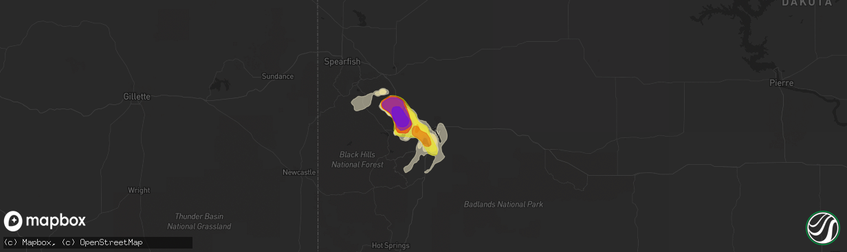
Hail
36,789
Estimated number of impacted properties by a 1.00" hail or larger893
Estimated number of impacted properties by a 1.75" hail or larger807
Estimated number of impacted properties by a 2.50" hail or largerStorm reports in Rapid City, SD
Rapid City, SD
| Date | Description |
|---|---|
| 07/17/20167:17 PM CDT | A local report indicates 1.50 inch wind near 1 N DOWNTOWN RAPID CITY |
| 07/17/20167:16 PM CDT | A local report indicates 1.00 inch wind near 1 NE DOWNTOWN RAPID CIT |
| 07/17/20167:13 PM CDT | Multiple large trees snapped in half. Picture submitted via facebook. |
| 07/17/20167:13 PM CDT | A local report indicates 1.50 inch wind near 1 E DOWNTOWN RAPID CITY |
| 07/17/20167:11 PM CDT | A local report indicates 60 MPH wind near 4 N DOWNTOWN RAPID CITY |
| 07/17/20167:00 PM CDT | Estimated 60 to 70 mph wind gust. 1 - 2 tree limbs down. |
All States Impacted by Hail Map on July 18, 2016
All Cities Impacted by Hail Map on July 18, 2016
- Macedon, NY
- Fairport, NY
- Walworth, NY
- Weld, ME
- Temple, ME
- Dade City, FL
- Enders, NE
- Wauneta, NE
- Lewellen, NE
- Big Springs, NE
- Brule, NE
- Hammond, NY
- Heuvelton, NY
- Ogdensburg, NY
- Paxton, NE
- Sutherland, NE
- Dudley, GA
- Dublin, GA
- Dexter, GA
- Corinna, ME
- Exeter, ME
- Zephyrhills, FL
- Storm Lake, IA
- Alta, IA
- Beresford, SD
- Cut Bank, MT
- Saint Regis Falls, NY
- Alvo, NE
- Murdock, NE
- Elmwood, NE
- Houston, TX
- Orange, VA
- Petersburg, IL
- Greenview, IL
- Raymond, NE
- Geyser, MT
- Denton, MT
- Coffee Creek, MT
- Stanford, MT
- Manville, WY
- Greeley, CO
- Madison, ME
- Norridgewock, ME
- New Vineyard, ME
- Farmington, ME
- Phillips, ME
- Strong, ME
- Anson, ME
- Saint Johnsbury, VT
- Littleton, NH
- Clyde, NY
- Savannah, NY
- Steinhatchee, FL
- Fort Peck, MT
- Rapid City, SD
- Aurelia, IA
- Holyoke, CO
- Wray, CO
- Custer, SD
- Sedalia, CO
- Castle Rock, CO
- Ivesdale, IL
- Caratunk, ME
- Imperial, NE
- Framingham, MA
- Ashland, MA
- Sherborn, MA
- Natick, MA
- Webster, FL
- Grover, CO
- Vermontville, NY
- Gillette, WY
- Upton, WY
- Oshkosh, NE
- Monarch, MT
- Neihart, MT
- Hilger, MT
- Cascade, MT
- White Sulphur Springs, MT
- Winifred, MT
- Lewistown, MT
- Raynesford, MT
- Stockett, MT
- Great Falls, MT
- Belt, MT
- Hopkinton, MA
- Au Sable Forks, NY
- Bloomingdale, NY
- Saranac Lake, NY
- Paul Smiths, NY
- Ashwood, OR
- Aguilar, CO
- Whitefish, MT
- Wasta, SD
- Julesburg, CO
- Amherst, CO
- Lodgepole, NE
- Otis, CO
- Cook, NE
- Keystone, SD
- Hermosa, SD
- Zortman, MT
- Chappell, NE
- Corinth, VT
- East Corinth, VT
- Bradford, VT
- Piermont, NH
- Browning, MT
- Colebrook, NH
- Errol, NH
- Lincoln, NE
- Danville, PA
- Muncy, PA
- Watsontown, PA
- Turbotville, PA
- Jersey Shore, PA
- Montgomery, PA
- Williamsport, PA
- Allenwood, PA
- New Columbia, PA
- Oldtown, MD
- Cumberland, MD
- Sundance, WY
- Hinsdale, MT
- Montgomery Center, VT
- Martville, NY
- Sterling, NY
- Hannibal, NY
- Wolcott, NY
- Red Creek, NY
- Champion, NE
- Paoli, CO
- Haxtun, CO
- Bartow, GA
- Lisbon, NH
- Bath, NH
- Saint Albans, ME
- Prineville, OR
- Powell Butte, OR
- Newport, ME
- Stetson, ME
- Carmel, ME
- Bangor, ME
- Palmyra, ME
- Plymouth, ME
- Etna, ME
- Callaway, NE
- Keenesburg, CO
- Hudson, CO
- Horseshoe Beach, FL
- Weeping Water, NE
- Avoca, NE
- Nehawka, NE
- Evans, CO
- La Salle, CO
- Bingham, ME
- Pittsburg, NH
- North Anson, ME
- Levant, ME
- Skowhegan, ME
- Athens, ME
- Harmony, ME
- Milford, ME
- New Portland, ME
- Hudson, ME
- Solon, ME
- Hartland, ME
- Kenduskeag, ME
- Dexter, ME
- Greenbush, ME
- Beecher Falls, VT
- Norton, VT
- Orono, ME
- Bradley, ME
- Canaan, VT
- Andover, ME
- Rangeley, ME
- Corinth, ME
- Old Town, ME
- Kingfield, ME
- Edgemont, SD
- Lusk, WY
- Lance Creek, WY
- Edgefield, SC
- Johnston, SC
- Rye, CO
- Beulah, CO
- Trego, MT
- Brighton, CO
- Smithfield, ME
- Waterville, ME
- Oakland, ME
- Fairfield, ME
- Crofton, NE
- Yankton, SD
- Saint Helena, NE
- Island Pond, VT
- New Sharon, ME
- Guildhall, VT
- Lake Lure, NC
- Sac City, IA
- Lake View, IA
- Malta, MT
- Ault, CO
- Sidney, NE
- Gurley, NE
- Canaan, ME
- Pittsfield, ME
- Pine Ridge, SD
- Heathsville, VA
- Reedville, VA
- Newberry, SC
- Mount Pulaski, IL
- Lincoln, IL
- Minatare, NE
- Scottsbluff, NE
- Worton, MD
- Wrightsville, GA
- Nemo, SD
- Barnet, VT
- Astoria, IL
- Havana, IL
- Summerville, OR
- Elgin, OR
- Vienna, GA
- Byromville, GA
- Cantonment, FL
- Enosburg Falls, VT
- Richford, VT
- East Berkshire, VT
- Ashton, IA
- Spartanburg, SC
- Alton, IA
- Remsen, IA
- Tabor, SD
- Yoder, WY
- Camden Wyoming, DE
- Viola, DE
- Fairmount, IL
- Indianola, IL
- Sioux Center, IA
- Hawarden, IA
- Columbia, SC
- Middleport, NY
- Basom, NY
- Medina, NY
- Parishville, NY
- Mill Spring, NC
- Bayard, NE
- Piedmont, SD
- Sturgis, SD
- Black Hawk, SD
- Rembert, SC
- Carlton, GA
- Wadley, GA
- Ruckersville, VA
- Heart Butte, MT
- Bridgeport, IL
- Lawrenceville, IL
- Saint Francisville, IL
- Golconda, IL
- Garfield, GA
- Montoursville, PA
- West Topsham, VT
- Fairlee, VT
- Washington, VT
- Orford, NH
- Loganville, GA
- Dacula, GA
- Grayson, GA
- Lawrenceville, GA
- Quimby, IA
- Anderson, SC
- Iva, SC
- Bennett, CO
- Commerce, GA
- Ellsworth, NE
- Statesboro, GA
- Sumner, IL
- Deadwood, SD
- Mission Hill, SD
- Utica, SD
- Moorcroft, WY
- Argenta, IL
- Cisco, IL
- Sedgwick, CO
- Crook, CO
- Altavista, VA
- Lynch Station, VA
- Ontario, NY
- Hershey, NE
- Williamstown, VT
- Graniteville, VT
- Wentworth, NH
- Topsham, VT
- Barre, VT
- Perryville, MO
- Fort Benton, MT
- Primghar, IA
- Hartley, IA
- North Troy, VT
- Malone, NY
- Cleghorn, IA
- Bethlehem, NH
- Monroe, NH
- Saluda, SC
- Lead, SD
- Warwick, MD
- Earleville, MD
- Marcus, IA
- Caputa, SD
- Hughesville, PA
- Kenney, IL
- Jordan, MT
- Brewer, ME
- Lisco, NE
- Plattsburgh, NY
- Peru, NY
- Lewistown, IL
- Topeka, IL
- Easton, IL
- Phoenix, AZ
- Newark, DE
- Brussels, IL
- Batchtown, IL
- Nebraska City, NE
- Eddington, ME
- North Henderson, IL
- Ellisville, IL
- Avon, IL
- London Mills, IL
- Canton, IL
- Bartow, FL
- Atlanta, IL
- Lakeland, FL
- Clinton, IL
- Waynesville, IL
- Red Bud, IL
- Evansville, IL
- Broadus, MT
- Dalton, NE
- Le Mars, IA
- Arcola, IL
- Humboldt, IL
- Gayville, SD
- Bridgeport, NE
- Wheatland, WY
- Allentown, PA
- Whitehall, PA
- Newcastle, WY
- Kershaw, SC
- Bethune, SC
- Waverly, NE
- Homer, NY
- Cortland, NY
- Locke, NY
- Buchanan, GA
- Galva, IA
- Early, IA
- Schaller, IA
- Beattyville, KY
- Stanardsville, VA
- Trenton, SC
- Glendo, WY
- Old Fort, NC
- Fleming, CO
- Newport, VT
- Newport Center, VT
- Mullen, NE
- Hurt, VA
- Morrill, NE
- Aiken, SC
- Groveland, FL
- Tallapoosa, GA
- Akron, CO
- Monticello, IL
- Roxbury, ME
- Dover, DE
- Felton, DE
- Magnolia, DE
- Gothenburg, NE
- Auburndale, FL
- Winter Haven, FL
- Logan, OH
- Ogallala, NE
- Troy, MT
- Bridgeport, CT
- Stratford, CT
- Lake Placid, NY
- Chesapeake City, MD
- Middletown, DE
- Windsor, SC
- Wilmington, NY
- Rainbow Lake, NY
- Rock Valley, IA
- Doon, IA
- Pesotum, IL
- Sadorus, IL
- Dyke, VA
- Harrisburg, NE
- Terryville, CT
- Danville, VT
- Ovid, CO
- Nags Head, NC
- La Grande, OR
- Penfield, NY
- Cozad, NE
- Somerset, VA
- Mason City, IL
- Bloomsdale, MO
- Hopkins, SC
- Springfield, IL
- Tryon, NE
- Chestertown, MD
- Volin, SD
- West Columbia, SC
- Lemoyne, NE
- Dieterich, IL
- Wheeler, IL
- Moravia, NY
- Oakfield, NY
- Akron, NY
- Fairview, IL
- Brazil, IN
- Teutopolis, IL
- Montrose, IL
- Roggen, CO
- Chambers, AZ
- East Dublin, GA
- Mitchell, NE
- Antelope, OR
- Sullivan, IL
- Lovington, IL
- Linden, PA
- Hindsboro, IL
- Oakland, IL
- Punta Gorda, FL
- Sugar Hill, NH
- Franconia, NH
- Martinsville, IN
- Derby Line, VT
- Rock Port, MO
- Westboro, MO
- Tarkio, MO
- Colton, NY
- Hull, IA
- Stratton, ME
- Greenwood, NE
- Otoe, NE
- Davey, NE
- Murray, NE
- Manley, NE
- Union, NE
- Louisville, NE
- Zolfo Springs, FL
- Graniteville, SC
- Valier, MT
- Camargo, IL
- Villa Grove, IL
- Tuscola, IL
- Atwood, IL
- Hudson, SD
- Sorrento, FL
- Sidney, IL
- Tolono, IL
- Philo, IL
- Guilford, ME
- Groton, NY
- Scipio Center, NY
- Genoa, NY
- Brady, NE
- Arnold, NE
- Limestone, ME
- Coin, IA
- Shenandoah, IA
- Green Spring, WV
- San Jose, IL
- Saint David, IL
- Cuba, IL
- Burgess, VA
- North Port, FL
- Nashua, MT
- Bude, MS
- Gerlaw, IL
- Quincy, IN
- Monrovia, IN
- Paragon, IN
- Coatesville, IN
- Clayton, IN
- Mooresville, IN
- Fillmore, IN
- Greencastle, IN
- Brooklyn, IN
- Morgantown, IN
- Stilesville, IN
- Carbon, IN
- Mapleton, ME
- Thurman, IA
- Sidney, IA
- Smithfield, IL
- Newton, IL
- Arthur, NE
- Merino, CO
- Hiawassee, GA
- Box Elder, SD
- Wall, SD
- Millen, GA
- Torrington, WY
- New Port Richey, FL
- Franklin, NC
- Saybrook, IL
- Hartsville, SC
- Millville, NJ
- Kingsley, IA
- Port Byron, NY
- Sangerville, ME
- Abbot, ME
- Andreas, PA
- Newport, NE
- Cheshire, MA
- Foley, MO
- Winfield, MO
- Watson, IL
- Effingham, IL
- Bronson, IA
- Satsuma, FL
- Sutherland, IA
- Wolf Point, MT
- Milton, FL
- Hamburg, IA
- Clermont, FL
- Winter Garden, FL
- Fairfield, CT
- Sherman, IL
- Williamsville, IL
- Lakeside, NE
- Biddle, MT
- Boyes, MT
- Cato, NY
- Pennellville, NY
- Moran, MI
- Saint Ignace, MI
- Mackinac Island, MI
- Pointe Aux Pins, MI
- Morgan, VT
- Whitefield, NH
- Clinton, MT
- Florence, MT
- Missoula, MT


