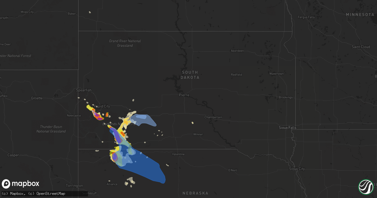
Hail Map in South Dakota on July 16, 2021
Get this storm
July 16 map
$229
one time, instant access
Download today. No call, no setup
Keep the $229
Bought the map and want the full workflow? Apply the entire $229 to a subscription within 7 days. None of it is wasted.
Every map, not just this one
This buys you this map. Subscription and you get every map we run, in the markets you choose from a few cities to whole states to nationwide. Plus real-time alerts the moment a storm fires.
Contact data
Name, contact info, occupancy, even credit band for addresses in the footprint. You go from where it hit to who to call.
Become the source they trust
Unlimited branding weather history reports on demand. You already have the documented answer ready for the property owner, and you are the one who showed up with it.
Property data and RoofTrace estimates
Pull up any address you have got, its value and the exact code rules for that jurisdiction, straight from One Click Code. Then RoofTrace estimates the squares, pitch, and roof value, priced the way you price.
Storm reports in South Dakota
South Dakota
| Date | Description |
|---|---|
| 07/16/20216:45 PM CDT | A local report indicates 60 MPH wind near 5 N SCENIC |
| 07/16/20216:19 PM CDT | A local report indicates 1.25 inch wind near 6 W HERMOSA |
| 07/16/20216:13 PM CDT | Hail ranged from pea size up to 2 inch in diameter. Hailed from 513 pm to 519 pm. Half inch of rain. |
| 07/16/20216:11 PM CDT | A local report indicates 1.75 inch wind near 6 SW HERMOSA |
| 07/16/20216:07 PM CDT | A local report indicates 1.75 inch wind near 7 W HERMOSA |
| 07/16/20216:02 PM CDT | A local report indicates 1.50 inch wind near 10 W HERMOSA |
| 07/16/20215:50 PM CDT | Hail occurred from 450 pm to 505 pm. 0.38 inches of rain. Rain ended at 522 pm. |
| 07/16/20215:38 PM CDT | Still hailing |
| 07/16/20215:35 PM CDT | A local report indicates 1.75 inch wind near 4 NE HILL CITY |
| 07/16/20215:35 PM CDT | A local report indicates 1.75 inch wind near 3 NW MOUNT RUSHMORE |
| 07/16/20215:30 PM CDT | A local report indicates 1.50 inch wind near 3 S PACTOLA RESV |
| 07/16/20215:25 PM CDT | A local report indicates 1.00 inch wind near 3 NW MOUNT RUSHMORE |
| 07/16/20215:18 PM CDT | A local report indicates 1.00 inch wind near 3 S MYSTIC |
| 07/16/20212:42 AM CDT | At 741 PM MDT, severe thunderstorms were located along a line extending from 9 miles northeast of Gordon to near Hay Springs, moving southeast at 25 mph. HAZARD...Golf ball size hail and 70 mph wind gusts. SOURCE...Radar indicated. IMPACT...People and animals outdoors will be injured. Expect hail damage to roofs, siding, windows, and vehicles. Expect considerable tree damage. Wind damage is also likely to mobile homes, roofs, and outbuildings. Locations impacted include... Gordon, Rushville, Hay Springs, Merriman, Medicine Lake, Clinton, Lone Butte, Irwin, Intersection of Beaver Creek Road and White Clay Creek Road, Rock Hill, Hoover Lake, Mount Maria, Intersection of Highway 20 and Irwin Road, Highway 250 crossing the Niobrara River, Walgren Lake, Shell Lake and Bayonne.This includes the following highways... Highway 20 between mile markers 74 and 147. Highway 250 between mile markers 23 and 48. Highway 61 between mile markers 202 and 231. |
| 07/16/20212:18 AM CDT | At 718 PM MDT/818 PM CDT/, severe thunderstorms were located along a line extending from 7 miles southwest of Billsburg to 4 miles southwest of Wanblee, moving east at 50 mph. HAZARD...70 mph wind gusts and half dollar size hail. SOURCE...Radar indicated. Winds were measured near 80 mph at Cactus Flat. IMPACT...Hail damage to vehicles is expected. Expect considerable tree damage. Wind damage is also likely to mobile homes, roofs, and outbuildings. Severe thunderstorms will be near... Wanblee around 725 PM MDT. George Town around 730 PM MDT.Other locations in the path of these severe thunderstorms includeOttumwa.This includes Interstate 90 in South Dakota between Mile Markers 125and 174. |
| 07/16/20212:13 AM CDT | At 713 PM MDT, a severe thunderstorm was located 7 miles east of Chadron, moving southeast at 20 mph. HAZARD...Two inch hail and 70 mph wind gusts. SOURCE...Radar indicated. IMPACT...People and animals outdoors will be injured. Expect hail damage to roofs, siding, windows, and vehicles. Expect considerable tree damage. Wind damage is also likely to mobile homes, roofs, and outbuildings. Locations impacted include... Hay Springs, Intersection of Beaver Creek Road and White Clay Creek Road, Intersection of Highway 87 and Antelope Road, Walgren Lake State Recreation Area and Metcalf State Wildlife Management Area.This includes Highway 20 between mile markers 74 and 84. |
| 07/16/20212:12 AM CDT | At 710 PM MDT, a severe thunderstorm was located 4 miles northwest of Wakpamni, or 16 miles east of Pine Ridge, moving southeast at 30 mph. HAZARD...Golf ball size hail and 70 mph wind gusts. SOURCE...Radar indicated. Tribal emergency management has received numerous calls of wind and hail damage. IMPACT...People and animals outdoors will be injured. Expect hail damage to roofs, siding, windows, and vehicles. Expect considerable tree damage. Wind damage is also likely to mobile homes, roofs, and outbuildings. This severe thunderstorm will be near... Batesland around 715 PM MDT. Wakpamni around 720 PM MDT. |
| 07/16/20211:46 AM CDT | At 645 PM MDT, a severe thunderstorm was located near Manderson, or 9 miles northeast of Pine Ridge, moving southeast at 30 mph. HAZARD...Two inch hail and 70 mph wind gusts. SOURCE...Radar indicated. IMPACT...People and animals outdoors will be injured. Expect hail damage to roofs, siding, windows, and vehicles. Expect considerable tree damage. Wind damage is also likely to mobile homes, roofs, and outbuildings. Locations impacted include... Gordon, Rushville, White Clay, Clinton, Intersection of Highway 87 and Craven Creek Road, Lone Butte, Irwin, Intersection of Highway 87 and Larabee Road, Mount Maria, Intersection of Highway 20 and Irwin Road, Shell Lake, Bayonne, Intersection of Highway 27 and Mills Road, Pine Ridge and Hoover Lake.This includes the following highways... Highway 20 between mile markers 85 and 127. Highway 250 between mile markers 45 and 48. |
| 07/16/20211:20 AM CDT | At 619 PM MDT, a severe thunderstorm was located 5 miles southwest of Pinnacles Ranger Station, or 35 miles southwest of Philip, moving east at 30 mph. HAZARD...Golf ball size hail and 60 mph wind gusts. SOURCE...Radar indicated. IMPACT...People and animals outdoors will be injured. Expect hail damage to roofs, siding, windows, and vehicles. Expect wind damage to roofs, siding, and trees. Locations impacted include... Interior, Cedar Pass, Delta 1 Launch Facility, Cactus Flat and Minuteman Missile Visitors Center.This includes Interstate 90 in South Dakota between Mile Markers 101and 145. |
| 07/16/20211:10 AM CDT | At 609 PM MDT, severe thunderstorms were located along a line extending from 5 miles southeast of Badlands National Park to near Dry Wood Housing, moving southeast at 25 mph. HAZARD...Golf ball size hail and 60 mph wind gusts. SOURCE...Radar indicated. IMPACT...People and animals outdoors will be injured. Expect hail damage to roofs, siding, windows, and vehicles. Expect wind damage to roofs, siding, and trees. Locations impacted include... Oglala, Loneman, South Lakeside, Manderson, Kyle North Route Housing, Number 4, Kyle, Calico, Pine Ridge, Wounded Knee, Wolf Creek Housing, Porcupine Butte Housing, Snake Butte and Yellow Bear Canyon. |
| 07/16/202112:31 AM CDT | At 530 PM MDT, severe thunderstorms were located along a line extending from 5 miles east of Hermosa to 5 miles northeast of Thunder Valley, moving east at 20 mph. HAZARD...Golf ball size hail and 60 mph wind gusts. SOURCE...Radar indicated. IMPACT...People and animals outdoors will be injured. Expect hail damage to roofs, siding, windows, and vehicles. Expect wind damage to roofs, siding, and trees. Severe thunderstorms will be near... Thunder Valley around 535 PM MDT. Kyle North Route Housing around 550 PM MDT.Other locations in the path of these severe thunderstorms includeKyle, Folsom, Farmingdale and Railroad Buttes.This includes Interstate 90 in South Dakota between Mile Markers 104and 120. |
| 07/16/202112:05 AM CDT | At 503 PM MDT, a severe thunderstorm was located 4 miles southwest of Hermosa, or 16 miles east of Custer, moving southeast at 20 mph. HAZARD...Golf ball size hail and 60 mph wind gusts. SOURCE...Radar indicated. IMPACT...People and animals outdoors will be injured. Expect hail damage to roofs, siding, windows, and vehicles. Expect wind damage to roofs, siding, and trees. This severe thunderstorm will be near... Hermosa around 515 PM MDT.Other locations in the path of this severe thunderstorm includeFairburn. |
| 07/15/202111:32 PM CDT | At 431 PM MDT, a severe thunderstorm was located over Mount Rushmore National Memorial, or 6 miles southeast of Hill City, moving south at 15 mph. HAZARD...Golf ball size hail and 60 mph wind gusts. SOURCE...Radar indicated. IMPACT...People and animals outdoors will be injured. Expect hail damage to roofs, siding, windows, and vehicles. Expect wind damage to roofs, siding, and trees. This severe thunderstorm will be near... Custer State Park around 435 PM MDT. Hayward around 440 PM MDT. Center Lake and Black Hills Playhouse around 450 PM MDT.Other locations in the path of this severe thunderstorm includeLegion Lake, Stockade Lake, Mount Coolidge, State Game Lodge, BlueBell and Buffalo Corrals. |
| 07/15/202110:55 PM CDT | At 355 PM MDT, a severe thunderstorm was located near Rochford, or 12 miles northwest of Hill City, moving southeast at 10 mph. HAZARD...Ping pong ball size hail and 60 mph wind gusts. SOURCE...Radar indicated. IMPACT...People and animals outdoors will be injured. Expect hail damage to roofs, siding, windows, and vehicles. Expect wind damage to roofs, siding, and trees. This severe thunderstorm will be near... Mystic around 410 PM MDT.Other locations in the path of this severe thunderstorm includeSilver City, Pactola Reservoir, Johnson Siding, Hill City, Keystone,Hisega, Rockerville, Sheridan Lake, Keystone Wye, Palmer GulchResort, Horse Thief Lake and Mount Rushmore National Memorial. |
| 07/15/20219:05 PM CDT | 55-60 mph wind lasted through 825 pm mdt. Speed estimated by the beaufort scale. |
| 07/15/20218:36 PM CDT | 3 inch tree limbs broken and power poles broken |
| 07/15/20218:16 PM CDT | A local report indicates 58 MPH wind near 3 E PHILIP |
| 07/15/20218:15 PM CDT | A local report indicates 60 MPH wind near 2 SSE PINE RIDGE |
| 07/15/20218:00 PM CDT | One rv and one trailer tipped over at cedar pass campground. |
| 07/15/20217:54 PM CDT | A local report indicates 68 MPH wind near 3 ESE PINE RIDGE |
| 07/15/20217:52 PM CDT | Time estimated from radar. |
| 07/15/20217:52 PM CDT | A local report indicates 66 MPH wind near 3 ESE PINE RIDGE |
| 07/15/20217:50 PM CDT | A local report indicates 83 MPH wind near 4 E CACTUS FLAT |
| 07/15/20217:41 PM CDT | 1 inch tree limbs broken and shingles blown off |
| 07/15/20217:25 PM CDT | A local report indicates 58 MPH wind near 8 S WALL |
| 07/15/20217:09 PM CDT | A local report indicates 58 MPH wind near 3 NW WASTA |
All States Impacted by Hail Map on July 16, 2021
Cities Impacted by Hail Map on July 16, 2021
- Forksville, PA
- Sesser, IL
- Benton, IL
- Lexington, SC
- Burlington, CO
- Kyle, SD
- Pine Ridge, SD
- Sedona, AZ
- Show Low, AZ
- Cheney, KS
- Norwich, KS
- Fowler, OH
- Burghill, OH
- Wakeeney, KS
- McCracken, KS
- Ellis, KS
- Hays, KS
- Scenic, SD
- Underwood, ND
- Sterling, ND
- Carmen, OK
- Hermosa, SD
- Caputa, SD
- Ninety Six, SC
- Saluda, SC
- Lead, SD
- Rapid City, SD
- Keystone, SD
- Hill City, SD
- Farnam, NE
- Clifton, AZ
- Elizabethtown, IN
- Scipio, IN
- North Vernon, IN
- Westport, IN
- Arriba, CO
- Pine, AZ
- Payson, AZ
- Ponca City, OK
- Newkirk, OK
- Holly, CO
- Muncy Valley, PA
- Channing, TX
- Karval, CO
- Beulah, ND
- Port Allegany, PA
- Roulette, PA
- Moorefield, NE
- Eustis, NE
- Manderson, SD
- Colorado City, AZ
- Roaring Branch, PA
- Liberty, PA
- Ralston, PA
- Rushville, NE
- Wall, SD
- Malta, ID
- Chadron, NE
- Cornville, AZ
- Conway Springs, KS
- Milton, KS
- Viola, KS
- Goddard, KS
- Garden Plain, KS
- Gordon, NE
- Gatewood, MO
- Doniphan, MO
- Hebron, ND
- Lock Haven, PA
- Wounded Knee, SD
- Medford, OK
- Genoa, CO
- Utica, OH
- Mount Vernon, OH
- Prosperity, SC
- Guymon, OK
- Gruver, TX
- Bethune, CO
- Stratton, CO
- Gilbert, SC
- Leesville, SC
- Cherokee, OK
- Richardton, ND
- Waynesville, OH
- Blythewood, SC
- Columbia, SC
- Clanton, AL
- Jemison, AL
- Akron, CO
- Zap, ND
- Slaughter, LA
- Zachary, LA
- Riverdale, ND
- Merriman, NE
- Waynesboro, GA
- Hay Springs, NE
- Batesland, SD
- Salina, OK
- Fordyce, AR
- Thornton, AR
- Pond Creek, OK
- Jet, OK
- Nash, OK
- Alton, UT
- Mineral Springs, AR
- Nashville, AR
- Madison, GA
- Porcupine, SD
- Ideal, SD
- Winner, SD
- La Crosse, KS
- Bison, KS
- Liebenthal, KS
- Norris, SD
- Lakeside, NE
- Oxford, NE
- Camp Verde, AZ
- Peridot, AZ
- San Carlos, AZ
- Weskan, KS
- Lopez, PA
- Deer Creek, OK
- Lamont, OK
- Wanblee, SD
- Interior, SD
- Troy, NC
- Denton, NC
- Burden, KS
- Blair, SC
- Alma, NE
- Orleans, NE
- Whitmire, SC
- Driscoll, ND
- Burlington, ND
- Minot, ND
- Midland, PA
- Industry, PA
- Beaver Falls, PA
- Albert, KS
- Otis, KS
- Dahlonega, GA
- Murrayville, GA
- Pelion, SC
- Madison, IN
- Cross Plains, IN
- Canaan, IN
- Alliance, NE
- Fairburn, SD
- Quinn, SD
- Adair, OK
- Tuba City, AZ
- Artesia, NM
- Dighton, KS
- Rhame, ND
- Drake, ND
- Youngstown, FL
- Petrolia, PA
- Karns City, PA
- Dushore, PA
- Washburn, ND
- Butlerville, IN
- Holton, IN
- McBee, SC
- Burneyville, OK
- Hazen, ND
- Stanton, ND
- Ellsworth, NE
- Dewey, AZ
- Marietta, OK
- Oshkosh, NE
- Du Bois, PA
- Reynoldsville, PA
- Luthersburg, PA
- Sykesville, PA
- Punxsutawney, PA
- Valentine, NE
- McCormick, SC
- Edgefield, SC
- Clearwater, KS
- Oglala, SD
- Salley, SC
- Wagener, SC
- Brady, NE
- Maxwell, NE
- Baker, LA
- Pawnee Rock, KS
- Great Bend, KS
- Rush Center, KS
- Turon, KS
- Loretto, KY
- Saint Francis, KY
- Freeport, KS
- Bluff City, KS
- Cuervo, NM
- Kinards, SC
- Joanna, SC
- Butler, PA
- Milan, KS
- Caldwell, KS
- Louisburg, NC
- Olar, SC
- Ehrhardt, SC
- Pryor, OK
- Coleharbor, ND
- Lincolnton, GA
- Dacoma, OK
- Cambridge, KS
- Atlanta, KS
- Bingham, NE
- El Dorado, AR
- Oelrichs, SD
- Ash Fork, AZ
- Collinsville, OK
- Vera, OK
- Whitney, NE
- West Sunbury, PA
- Columbia, CT
- Amston, CT
- Andover, CT
- Hebron, CT
- Lebanon, CT
- Virginia Beach, VA
- Warrenton, NC
- Flagstaff, AZ
- Holdrege, NE
- Littlefield, AZ
- Stamford, NE
- Kit Carson, CO
- Cortland, OH
- Arapahoe, CO
- Lebanon, KY
- Mount Vernon, KY
- Orlando, KY
- Sardis, OH
- Hoisington, KS
- Olmitz, KS
- Little Mountain, SC
- Parmelee, SD
- Elberton, GA
- Butner, NC
- Troy, SC
- Spavinaw, OK
- Rebersburg, PA
- Mifflinburg, PA
- Greenwood, FL
- Martin, SD
- Berthold, ND
- Belle Plaine, KS
- Hartsville, SC
- St John, KS
- Spearman, TX
- Otis, CO
- Hillsgrove, PA
- Goodwell, OK
- Dragoon, AZ
- Strang, OK
- Marianna, FL
- Whitman, NE
- Cody, NE
- Ashby, NE
- Long Valley, SD
- Kadoka, SD
- Custer, SD
- Smethport, PA


