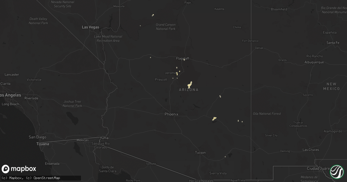
Hail Map in Arizona on July 16, 2021
Get this storm
July 16 map
$229
one time, instant access
Download today. No call, no setup
Keep the $229
Bought the map and want the full workflow? Apply the entire $229 to a subscription within 7 days. None of it is wasted.
Every map, not just this one
This buys you this map. Subscription and you get every map we run, in the markets you choose from a few cities to whole states to nationwide. Plus real-time alerts the moment a storm fires.
Contact data
Name, contact info, occupancy, even credit band for addresses in the footprint. You go from where it hit to who to call.
Become the source they trust
Unlimited branding weather history reports on demand. You already have the documented answer ready for the property owner, and you are the one who showed up with it.
Property data and RoofTrace estimates
Pull up any address you have got, its value and the exact code rules for that jurisdiction, straight from One Click Code. Then RoofTrace estimates the squares, pitch, and roof value, priced the way you price.
Storm reports in Arizona
Arizona
| Date | Description |
|---|---|
| 07/16/202112:30 AM CDT | At 527 PM MST, Severe thunderstorms were located 9 miles south of Childs Power Plant, moving southwest at 10 mph. HAZARD...Half dollar size hail. SOURCE...Radar indicated. IMPACT...Damage to vehicles is expected. Locations impacted include... Payson, Childs Power Plant, East Verde Estates and Tonto Natural Bridge State Park may be impacted. Storms are becoming quickly severe then just as rapidly dissipating. |
| 07/16/202112:19 AM CDT | At 519 PM MST, a severe thunderstorm was located near Childs Power Plant, or 15 miles southeast of Camp Verde, and is nearly stationary. HAZARD...Quarter size hail. SOURCE...Radar indicated. IMPACT...Damage to vehicles is expected. This severe thunderstorm will remain over mainly rural areas of Yavapai County. |
| 07/15/202111:59 PM CDT | At 458 PM MST, a severe thunderstorm was located over Childs Power Plant, or 19 miles southeast of Camp Verde, and is nearly stationary. HAZARD...Quarter size hail and wind gusts to 45 mph. SOURCE...Radar indicated. IMPACT...Hail damage to vehicles is expected. Locations impacted include... Childs Power Plant. |
| 07/15/202111:48 PM CDT | At 447 PM MST, a severe thunderstorm was located near Pine, or 9 miles northwest of Payson, and is nearly stationary. HAZARD...Ping pong ball size hail and 45 mph wind gusts. SOURCE...Radar indicated. IMPACT...People and animals outdoors will be injured. Expect hail damage to roofs, siding, windows, and vehicles. This severe thunderstorm will remain over mainly rural areas of Gila and Coconino Counties. |
| 07/15/202111:34 PM CDT | At 433 PM MST, a severe thunderstorm was located over Geronimo Estates, or 10 miles north of Payson, and is nearly stationary. HAZARD...Quarter size hail and 45 mph wind gust. SOURCE...Radar indicated. IMPACT...Hail damage to vehicles is expected. Locations impacted include... Geronimo Estates. |
| 07/15/202111:18 PM CDT | At 417 PM MST, a severe thunderstorm was located over Cornville, or 9 miles north of Camp Verde, and is nearly stationary. HAZARD...50 mph wind gusts and quarter size hail. SOURCE...Radar indicated. IMPACT...Hail damage to vehicles is expected. Locations impacted include... Cornville. |
| 07/15/202111:10 PM CDT | Van buren st. Closed between 175th ave and citrus rd. Due to downed power lines. Law enforcement social media post. |
| 07/15/202110:43 PM CDT | At 342 PM MST, a severe thunderstorm was located over Village At Oak Creek, or near Sedona, and is nearly stationary. HAZARD...45 mph wind gusts and up to quarter size hail. SOURCE...Radar indicated. IMPACT...Hail damage to vehicles is expected. Locations impacted include... Sedona, Village At Oak Creek and Red Rock State Park. |
| 07/15/20219:13 PM CDT | At 213 PM MST, a severe thunderstorm was located over Carrizo, or 21 miles southwest of Show Low, moving southwest at 10 mph. HAZARD...60 mph wind gusts and quarter size hail. SOURCE...Radar indicated. IMPACT...Hail damage to vehicles is expected. Expect wind damage to roofs, siding, and trees. Locations impacted include... Carrizo and Fort Apache Reservation. |
| 07/15/20219:03 PM CDT | At 201 PM MST, a group of severe thunderstorms was indicated north of a Solomon to Safford to Fort Thomas line. These storms are moving to the moving south at 25 mph. HAZARD...60 mph wind gusts. SOURCE...Radar indicated. IMPACT...Expect damage to roofs, siding, and trees. Locations impacted include... Safford, Clifton, Thatcher, Solomon, Morenci, Roper Lake State Park, Safford Regional Airport, Pima, Central, Fort Thomas, Three Way, Swift Trail Junction and Guthrie.This includes the following highways... Route 70 between mile markers 300 and 370. Route 75 between mile markers 397 and 398. Route 78 between mile markers 155 and 156. Route 191 between mile markers 113 and 175. |
| 07/15/20218:24 PM CDT | At 124 PM MST, a severe thunderstorm was located near Carrizo and is nearly stationary. HAZARD...60 mph wind gusts and quarter size hail. SOURCE...Radar indicated. IMPACT...Hail damage to vehicles is expected. Expect wind damage to roofs, siding, and trees. Locations impacted include... Fort Apache Reservation, Carrizo, Cedar Creek and White Mountain Apache Reservation. |
| 07/15/20218:16 PM CDT | At 115 PM MST, a severe thunderstorm was located near Flagstaff, moving south at 10 mph. HAZARD...60 mph wind gusts and quarter size hail. SOURCE...Radar indicated. IMPACT...Hail damage to vehicles is expected. Expect wind damage to roofs, siding, and trees. Locations impacted include... Flagstaff, Walnut Canyon National Monument, Upper Lake Mary Boat Ramps, Walnut Canyon Visitors Center, Lower Lake Mary, Canyon Vista Campground, Lake View Campground and Upper Lake Mary. |
All States Impacted by Hail Map on July 16, 2021
Cities Impacted by Hail Map on July 16, 2021
- Forksville, PA
- Sesser, IL
- Benton, IL
- Lexington, SC
- Burlington, CO
- Kyle, SD
- Pine Ridge, SD
- Sedona, AZ
- Show Low, AZ
- Cheney, KS
- Norwich, KS
- Fowler, OH
- Burghill, OH
- Wakeeney, KS
- McCracken, KS
- Ellis, KS
- Hays, KS
- Scenic, SD
- Underwood, ND
- Sterling, ND
- Carmen, OK
- Hermosa, SD
- Caputa, SD
- Ninety Six, SC
- Saluda, SC
- Lead, SD
- Rapid City, SD
- Keystone, SD
- Hill City, SD
- Farnam, NE
- Clifton, AZ
- Elizabethtown, IN
- Scipio, IN
- North Vernon, IN
- Westport, IN
- Arriba, CO
- Pine, AZ
- Payson, AZ
- Ponca City, OK
- Newkirk, OK
- Holly, CO
- Muncy Valley, PA
- Channing, TX
- Karval, CO
- Beulah, ND
- Port Allegany, PA
- Roulette, PA
- Moorefield, NE
- Eustis, NE
- Manderson, SD
- Colorado City, AZ
- Roaring Branch, PA
- Liberty, PA
- Ralston, PA
- Rushville, NE
- Wall, SD
- Malta, ID
- Chadron, NE
- Cornville, AZ
- Conway Springs, KS
- Milton, KS
- Viola, KS
- Goddard, KS
- Garden Plain, KS
- Gordon, NE
- Gatewood, MO
- Doniphan, MO
- Hebron, ND
- Lock Haven, PA
- Wounded Knee, SD
- Medford, OK
- Genoa, CO
- Utica, OH
- Mount Vernon, OH
- Prosperity, SC
- Guymon, OK
- Gruver, TX
- Bethune, CO
- Stratton, CO
- Gilbert, SC
- Leesville, SC
- Cherokee, OK
- Richardton, ND
- Waynesville, OH
- Blythewood, SC
- Columbia, SC
- Clanton, AL
- Jemison, AL
- Akron, CO
- Zap, ND
- Slaughter, LA
- Zachary, LA
- Riverdale, ND
- Merriman, NE
- Waynesboro, GA
- Hay Springs, NE
- Batesland, SD
- Salina, OK
- Fordyce, AR
- Thornton, AR
- Pond Creek, OK
- Jet, OK
- Nash, OK
- Alton, UT
- Mineral Springs, AR
- Nashville, AR
- Madison, GA
- Porcupine, SD
- Ideal, SD
- Winner, SD
- La Crosse, KS
- Bison, KS
- Liebenthal, KS
- Norris, SD
- Lakeside, NE
- Oxford, NE
- Camp Verde, AZ
- Peridot, AZ
- San Carlos, AZ
- Weskan, KS
- Lopez, PA
- Deer Creek, OK
- Lamont, OK
- Wanblee, SD
- Interior, SD
- Troy, NC
- Denton, NC
- Burden, KS
- Blair, SC
- Alma, NE
- Orleans, NE
- Whitmire, SC
- Driscoll, ND
- Burlington, ND
- Minot, ND
- Midland, PA
- Industry, PA
- Beaver Falls, PA
- Albert, KS
- Otis, KS
- Dahlonega, GA
- Murrayville, GA
- Pelion, SC
- Madison, IN
- Cross Plains, IN
- Canaan, IN
- Alliance, NE
- Fairburn, SD
- Quinn, SD
- Adair, OK
- Tuba City, AZ
- Artesia, NM
- Dighton, KS
- Rhame, ND
- Drake, ND
- Youngstown, FL
- Petrolia, PA
- Karns City, PA
- Dushore, PA
- Washburn, ND
- Butlerville, IN
- Holton, IN
- McBee, SC
- Burneyville, OK
- Hazen, ND
- Stanton, ND
- Ellsworth, NE
- Dewey, AZ
- Marietta, OK
- Oshkosh, NE
- Du Bois, PA
- Reynoldsville, PA
- Luthersburg, PA
- Sykesville, PA
- Punxsutawney, PA
- Valentine, NE
- McCormick, SC
- Edgefield, SC
- Clearwater, KS
- Oglala, SD
- Salley, SC
- Wagener, SC
- Brady, NE
- Maxwell, NE
- Baker, LA
- Pawnee Rock, KS
- Great Bend, KS
- Rush Center, KS
- Turon, KS
- Loretto, KY
- Saint Francis, KY
- Freeport, KS
- Bluff City, KS
- Cuervo, NM
- Kinards, SC
- Joanna, SC
- Butler, PA
- Milan, KS
- Caldwell, KS
- Louisburg, NC
- Olar, SC
- Ehrhardt, SC
- Pryor, OK
- Coleharbor, ND
- Lincolnton, GA
- Dacoma, OK
- Cambridge, KS
- Atlanta, KS
- Bingham, NE
- El Dorado, AR
- Oelrichs, SD
- Ash Fork, AZ
- Collinsville, OK
- Vera, OK
- Whitney, NE
- West Sunbury, PA
- Columbia, CT
- Amston, CT
- Andover, CT
- Hebron, CT
- Lebanon, CT
- Virginia Beach, VA
- Warrenton, NC
- Flagstaff, AZ
- Holdrege, NE
- Littlefield, AZ
- Stamford, NE
- Kit Carson, CO
- Cortland, OH
- Arapahoe, CO
- Lebanon, KY
- Mount Vernon, KY
- Orlando, KY
- Sardis, OH
- Hoisington, KS
- Olmitz, KS
- Little Mountain, SC
- Parmelee, SD
- Elberton, GA
- Butner, NC
- Troy, SC
- Spavinaw, OK
- Rebersburg, PA
- Mifflinburg, PA
- Greenwood, FL
- Martin, SD
- Berthold, ND
- Belle Plaine, KS
- Hartsville, SC
- St John, KS
- Spearman, TX
- Otis, CO
- Hillsgrove, PA
- Goodwell, OK
- Dragoon, AZ
- Strang, OK
- Marianna, FL
- Whitman, NE
- Cody, NE
- Ashby, NE
- Long Valley, SD
- Kadoka, SD
- Custer, SD
- Smethport, PA


