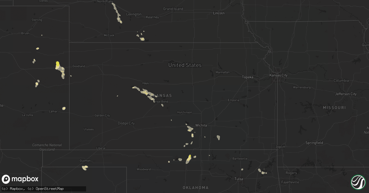
Hail Map in Kansas on July 16, 2021
Get this storm
July 16 map
$229
one time, instant access
Download today. No call, no setup
Keep the $229
Bought the map and want the full workflow? Apply the entire $229 to a subscription within 7 days. None of it is wasted.
Every map, not just this one
This buys you this map. Subscription and you get every map we run, in the markets you choose from a few cities to whole states to nationwide. Plus real-time alerts the moment a storm fires.
Contact data
Name, contact info, occupancy, even credit band for addresses in the footprint. You go from where it hit to who to call.
Become the source they trust
Unlimited branding weather history reports on demand. You already have the documented answer ready for the property owner, and you are the one who showed up with it.
Property data and RoofTrace estimates
Pull up any address you have got, its value and the exact code rules for that jurisdiction, straight from One Click Code. Then RoofTrace estimates the squares, pitch, and roof value, priced the way you price.
Storm reports in Kansas
Kansas
| Date | Description |
|---|---|
| 07/16/20214:20 AM CDT | At 920 PM MDT, a severe thunderstorm was located near Hartman, or 16 miles northwest of Coolidge, moving northeast at 30 mph. HAZARD...60 mph wind gusts and quarter size hail. SOURCE...Radar indicated. IMPACT...Hail damage to vehicles is expected. Expect wind damage to roofs, siding, and trees. Locations impacted include... Hartman and Bristol. |
| 07/15/202111:52 PM CDT | At 452 PM CDT, a severe thunderstorm was located near Viola, or near Conway Springs, moving southeast at 15 mph. HAZARD...60 mph wind gusts and quarter size hail. SOURCE...Radar indicated. IMPACT...Hail damage to vehicles is expected. Expect wind damage to roofs, siding, and trees. This severe thunderstorm will be near... Conway Springs around 510 PM CDT.Other locations in the path of this severe thunderstorm includeWellington.This includes Interstate 35 between Mile Markers 3 and 21. |
| 07/15/202111:00 PM CDT | Report was from ksdot site k5c00. |
All States Impacted by Hail Map on July 16, 2021
Cities Impacted by Hail Map on July 16, 2021
- Forksville, PA
- Sesser, IL
- Benton, IL
- Lexington, SC
- Burlington, CO
- Kyle, SD
- Pine Ridge, SD
- Sedona, AZ
- Show Low, AZ
- Cheney, KS
- Norwich, KS
- Fowler, OH
- Burghill, OH
- Wakeeney, KS
- McCracken, KS
- Ellis, KS
- Hays, KS
- Scenic, SD
- Underwood, ND
- Sterling, ND
- Carmen, OK
- Hermosa, SD
- Caputa, SD
- Ninety Six, SC
- Saluda, SC
- Lead, SD
- Rapid City, SD
- Keystone, SD
- Hill City, SD
- Farnam, NE
- Clifton, AZ
- Elizabethtown, IN
- Scipio, IN
- North Vernon, IN
- Westport, IN
- Arriba, CO
- Pine, AZ
- Payson, AZ
- Ponca City, OK
- Newkirk, OK
- Holly, CO
- Muncy Valley, PA
- Channing, TX
- Karval, CO
- Beulah, ND
- Port Allegany, PA
- Roulette, PA
- Moorefield, NE
- Eustis, NE
- Manderson, SD
- Colorado City, AZ
- Roaring Branch, PA
- Liberty, PA
- Ralston, PA
- Rushville, NE
- Wall, SD
- Malta, ID
- Chadron, NE
- Cornville, AZ
- Conway Springs, KS
- Milton, KS
- Viola, KS
- Goddard, KS
- Garden Plain, KS
- Gordon, NE
- Gatewood, MO
- Doniphan, MO
- Hebron, ND
- Lock Haven, PA
- Wounded Knee, SD
- Medford, OK
- Genoa, CO
- Utica, OH
- Mount Vernon, OH
- Prosperity, SC
- Guymon, OK
- Gruver, TX
- Bethune, CO
- Stratton, CO
- Gilbert, SC
- Leesville, SC
- Cherokee, OK
- Richardton, ND
- Waynesville, OH
- Blythewood, SC
- Columbia, SC
- Clanton, AL
- Jemison, AL
- Akron, CO
- Zap, ND
- Slaughter, LA
- Zachary, LA
- Riverdale, ND
- Merriman, NE
- Waynesboro, GA
- Hay Springs, NE
- Batesland, SD
- Salina, OK
- Fordyce, AR
- Thornton, AR
- Pond Creek, OK
- Jet, OK
- Nash, OK
- Alton, UT
- Mineral Springs, AR
- Nashville, AR
- Madison, GA
- Porcupine, SD
- Ideal, SD
- Winner, SD
- La Crosse, KS
- Bison, KS
- Liebenthal, KS
- Norris, SD
- Lakeside, NE
- Oxford, NE
- Camp Verde, AZ
- Peridot, AZ
- San Carlos, AZ
- Weskan, KS
- Lopez, PA
- Deer Creek, OK
- Lamont, OK
- Wanblee, SD
- Interior, SD
- Troy, NC
- Denton, NC
- Burden, KS
- Blair, SC
- Alma, NE
- Orleans, NE
- Whitmire, SC
- Driscoll, ND
- Burlington, ND
- Minot, ND
- Midland, PA
- Industry, PA
- Beaver Falls, PA
- Albert, KS
- Otis, KS
- Dahlonega, GA
- Murrayville, GA
- Pelion, SC
- Madison, IN
- Cross Plains, IN
- Canaan, IN
- Alliance, NE
- Fairburn, SD
- Quinn, SD
- Adair, OK
- Tuba City, AZ
- Artesia, NM
- Dighton, KS
- Rhame, ND
- Drake, ND
- Youngstown, FL
- Petrolia, PA
- Karns City, PA
- Dushore, PA
- Washburn, ND
- Butlerville, IN
- Holton, IN
- McBee, SC
- Burneyville, OK
- Hazen, ND
- Stanton, ND
- Ellsworth, NE
- Dewey, AZ
- Marietta, OK
- Oshkosh, NE
- Du Bois, PA
- Reynoldsville, PA
- Luthersburg, PA
- Sykesville, PA
- Punxsutawney, PA
- Valentine, NE
- McCormick, SC
- Edgefield, SC
- Clearwater, KS
- Oglala, SD
- Salley, SC
- Wagener, SC
- Brady, NE
- Maxwell, NE
- Baker, LA
- Pawnee Rock, KS
- Great Bend, KS
- Rush Center, KS
- Turon, KS
- Loretto, KY
- Saint Francis, KY
- Freeport, KS
- Bluff City, KS
- Cuervo, NM
- Kinards, SC
- Joanna, SC
- Butler, PA
- Milan, KS
- Caldwell, KS
- Louisburg, NC
- Olar, SC
- Ehrhardt, SC
- Pryor, OK
- Coleharbor, ND
- Lincolnton, GA
- Dacoma, OK
- Cambridge, KS
- Atlanta, KS
- Bingham, NE
- El Dorado, AR
- Oelrichs, SD
- Ash Fork, AZ
- Collinsville, OK
- Vera, OK
- Whitney, NE
- West Sunbury, PA
- Columbia, CT
- Amston, CT
- Andover, CT
- Hebron, CT
- Lebanon, CT
- Virginia Beach, VA
- Warrenton, NC
- Flagstaff, AZ
- Holdrege, NE
- Littlefield, AZ
- Stamford, NE
- Kit Carson, CO
- Cortland, OH
- Arapahoe, CO
- Lebanon, KY
- Mount Vernon, KY
- Orlando, KY
- Sardis, OH
- Hoisington, KS
- Olmitz, KS
- Little Mountain, SC
- Parmelee, SD
- Elberton, GA
- Butner, NC
- Troy, SC
- Spavinaw, OK
- Rebersburg, PA
- Mifflinburg, PA
- Greenwood, FL
- Martin, SD
- Berthold, ND
- Belle Plaine, KS
- Hartsville, SC
- St John, KS
- Spearman, TX
- Otis, CO
- Hillsgrove, PA
- Goodwell, OK
- Dragoon, AZ
- Strang, OK
- Marianna, FL
- Whitman, NE
- Cody, NE
- Ashby, NE
- Long Valley, SD
- Kadoka, SD
- Custer, SD
- Smethport, PA


