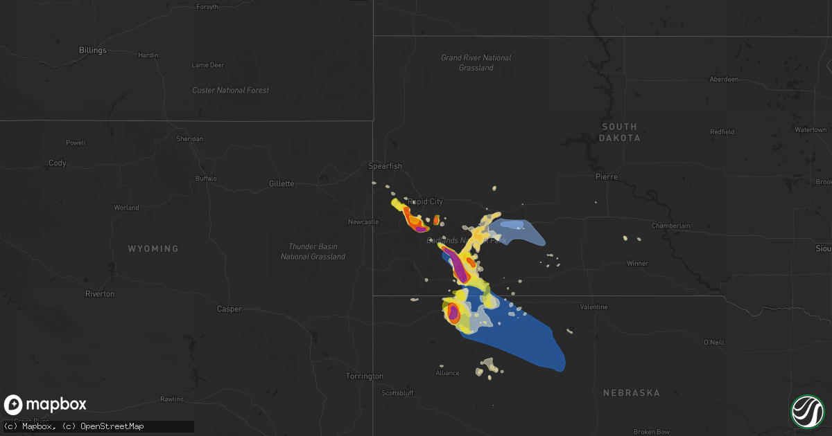
Hail Map on July 16, 2021
Get this storm
July 16 map
$229
one time, instant access
Download today. No call, no setup
Keep the $229
Bought the map and want the full workflow? Apply the entire $229 to a subscription within 7 days. None of it is wasted.
Every map, not just this one
This buys you this map. Subscription and you get every map we run, in the markets you choose from a few cities to whole states to nationwide. Plus real-time alerts the moment a storm fires.
Contact data
Name, contact info, occupancy, even credit band for addresses in the footprint. You go from where it hit to who to call.
Become the source they trust
Unlimited branding weather history reports on demand. You already have the documented answer ready for the property owner, and you are the one who showed up with it.
Property data and RoofTrace estimates
Pull up any address you have got, its value and the exact code rules for that jurisdiction, straight from One Click Code. Then RoofTrace estimates the squares, pitch, and roof value, priced the way you price.
States Impacted by Hail Map on July 16, 2021
Storm reports
Mississippi
| Date | Description |
|---|---|
| 07/16/20214:34 PM CDT | Picture of a tree on a home. Likely fell due to a combination of saturated soils and sub-severe wind gusts. |
| 07/16/20216:19 AM CDT | At 1118 AM CDT, a severe thunderstorm was located over White Oak, or 11 miles northeast of Mendenhall, moving east at 5 mph. HAZARD...60 mph wind gusts and quarter size hail. SOURCE...Radar indicated. IMPACT...Hail damage to vehicles is expected. Expect wind damage to roofs, siding, and trees. This severe thunderstorm will be near... White Oak around 1130 AM CDT. Raleigh and Burns around 1215 PM CDT.Other locations impacted by this severe thunderstorm includePolkville and Puckett. |
| 07/15/20219:37 PM CDT | At 237 PM CDT, a severe thunderstorm was located near Starkville, moving northeast at 20 mph. HAZARD...60 mph wind gusts and nickel size hail. SOURCE...Radar indicated. IMPACT...Expect damage to roofs, siding, and trees. This severe thunderstorm will be near... Muldrow around 250 PM CDT. Tibbee around 300 PM CDT. West Point around 305 PM CDT.Other locations impacted by this severe thunderstorm include Artesia. |
South Dakota
| Date | Description |
|---|---|
| 07/16/20216:45 PM CDT | A local report indicates 60 MPH wind near 5 N SCENIC |
| 07/16/20216:19 PM CDT | A local report indicates 1.25 inch wind near 6 W HERMOSA |
| 07/16/20216:13 PM CDT | Hail ranged from pea size up to 2 inch in diameter. Hailed from 513 pm to 519 pm. Half inch of rain. |
| 07/16/20216:11 PM CDT | A local report indicates 1.75 inch wind near 6 SW HERMOSA |
| 07/16/20216:07 PM CDT | A local report indicates 1.75 inch wind near 7 W HERMOSA |
| 07/16/20216:02 PM CDT | A local report indicates 1.50 inch wind near 10 W HERMOSA |
| 07/16/20215:50 PM CDT | Hail occurred from 450 pm to 505 pm. 0.38 inches of rain. Rain ended at 522 pm. |
| 07/16/20215:38 PM CDT | Still hailing |
| 07/16/20215:35 PM CDT | A local report indicates 1.75 inch wind near 4 NE HILL CITY |
| 07/16/20215:35 PM CDT | A local report indicates 1.75 inch wind near 3 NW MOUNT RUSHMORE |
| 07/16/20215:30 PM CDT | A local report indicates 1.50 inch wind near 3 S PACTOLA RESV |
| 07/16/20215:25 PM CDT | A local report indicates 1.00 inch wind near 3 NW MOUNT RUSHMORE |
| 07/16/20215:18 PM CDT | A local report indicates 1.00 inch wind near 3 S MYSTIC |
| 07/16/20212:42 AM CDT | At 741 PM MDT, severe thunderstorms were located along a line extending from 9 miles northeast of Gordon to near Hay Springs, moving southeast at 25 mph. HAZARD...Golf ball size hail and 70 mph wind gusts. SOURCE...Radar indicated. IMPACT...People and animals outdoors will be injured. Expect hail damage to roofs, siding, windows, and vehicles. Expect considerable tree damage. Wind damage is also likely to mobile homes, roofs, and outbuildings. Locations impacted include... Gordon, Rushville, Hay Springs, Merriman, Medicine Lake, Clinton, Lone Butte, Irwin, Intersection of Beaver Creek Road and White Clay Creek Road, Rock Hill, Hoover Lake, Mount Maria, Intersection of Highway 20 and Irwin Road, Highway 250 crossing the Niobrara River, Walgren Lake, Shell Lake and Bayonne.This includes the following highways... Highway 20 between mile markers 74 and 147. Highway 250 between mile markers 23 and 48. Highway 61 between mile markers 202 and 231. |
| 07/16/20212:18 AM CDT | At 718 PM MDT/818 PM CDT/, severe thunderstorms were located along a line extending from 7 miles southwest of Billsburg to 4 miles southwest of Wanblee, moving east at 50 mph. HAZARD...70 mph wind gusts and half dollar size hail. SOURCE...Radar indicated. Winds were measured near 80 mph at Cactus Flat. IMPACT...Hail damage to vehicles is expected. Expect considerable tree damage. Wind damage is also likely to mobile homes, roofs, and outbuildings. Severe thunderstorms will be near... Wanblee around 725 PM MDT. George Town around 730 PM MDT.Other locations in the path of these severe thunderstorms includeOttumwa.This includes Interstate 90 in South Dakota between Mile Markers 125and 174. |
| 07/16/20212:13 AM CDT | At 713 PM MDT, a severe thunderstorm was located 7 miles east of Chadron, moving southeast at 20 mph. HAZARD...Two inch hail and 70 mph wind gusts. SOURCE...Radar indicated. IMPACT...People and animals outdoors will be injured. Expect hail damage to roofs, siding, windows, and vehicles. Expect considerable tree damage. Wind damage is also likely to mobile homes, roofs, and outbuildings. Locations impacted include... Hay Springs, Intersection of Beaver Creek Road and White Clay Creek Road, Intersection of Highway 87 and Antelope Road, Walgren Lake State Recreation Area and Metcalf State Wildlife Management Area.This includes Highway 20 between mile markers 74 and 84. |
| 07/16/20212:12 AM CDT | At 710 PM MDT, a severe thunderstorm was located 4 miles northwest of Wakpamni, or 16 miles east of Pine Ridge, moving southeast at 30 mph. HAZARD...Golf ball size hail and 70 mph wind gusts. SOURCE...Radar indicated. Tribal emergency management has received numerous calls of wind and hail damage. IMPACT...People and animals outdoors will be injured. Expect hail damage to roofs, siding, windows, and vehicles. Expect considerable tree damage. Wind damage is also likely to mobile homes, roofs, and outbuildings. This severe thunderstorm will be near... Batesland around 715 PM MDT. Wakpamni around 720 PM MDT. |
| 07/16/20211:46 AM CDT | At 645 PM MDT, a severe thunderstorm was located near Manderson, or 9 miles northeast of Pine Ridge, moving southeast at 30 mph. HAZARD...Two inch hail and 70 mph wind gusts. SOURCE...Radar indicated. IMPACT...People and animals outdoors will be injured. Expect hail damage to roofs, siding, windows, and vehicles. Expect considerable tree damage. Wind damage is also likely to mobile homes, roofs, and outbuildings. Locations impacted include... Gordon, Rushville, White Clay, Clinton, Intersection of Highway 87 and Craven Creek Road, Lone Butte, Irwin, Intersection of Highway 87 and Larabee Road, Mount Maria, Intersection of Highway 20 and Irwin Road, Shell Lake, Bayonne, Intersection of Highway 27 and Mills Road, Pine Ridge and Hoover Lake.This includes the following highways... Highway 20 between mile markers 85 and 127. Highway 250 between mile markers 45 and 48. |
| 07/16/20211:20 AM CDT | At 619 PM MDT, a severe thunderstorm was located 5 miles southwest of Pinnacles Ranger Station, or 35 miles southwest of Philip, moving east at 30 mph. HAZARD...Golf ball size hail and 60 mph wind gusts. SOURCE...Radar indicated. IMPACT...People and animals outdoors will be injured. Expect hail damage to roofs, siding, windows, and vehicles. Expect wind damage to roofs, siding, and trees. Locations impacted include... Interior, Cedar Pass, Delta 1 Launch Facility, Cactus Flat and Minuteman Missile Visitors Center.This includes Interstate 90 in South Dakota between Mile Markers 101and 145. |
| 07/16/20211:10 AM CDT | At 609 PM MDT, severe thunderstorms were located along a line extending from 5 miles southeast of Badlands National Park to near Dry Wood Housing, moving southeast at 25 mph. HAZARD...Golf ball size hail and 60 mph wind gusts. SOURCE...Radar indicated. IMPACT...People and animals outdoors will be injured. Expect hail damage to roofs, siding, windows, and vehicles. Expect wind damage to roofs, siding, and trees. Locations impacted include... Oglala, Loneman, South Lakeside, Manderson, Kyle North Route Housing, Number 4, Kyle, Calico, Pine Ridge, Wounded Knee, Wolf Creek Housing, Porcupine Butte Housing, Snake Butte and Yellow Bear Canyon. |
| 07/16/202112:31 AM CDT | At 530 PM MDT, severe thunderstorms were located along a line extending from 5 miles east of Hermosa to 5 miles northeast of Thunder Valley, moving east at 20 mph. HAZARD...Golf ball size hail and 60 mph wind gusts. SOURCE...Radar indicated. IMPACT...People and animals outdoors will be injured. Expect hail damage to roofs, siding, windows, and vehicles. Expect wind damage to roofs, siding, and trees. Severe thunderstorms will be near... Thunder Valley around 535 PM MDT. Kyle North Route Housing around 550 PM MDT.Other locations in the path of these severe thunderstorms includeKyle, Folsom, Farmingdale and Railroad Buttes.This includes Interstate 90 in South Dakota between Mile Markers 104and 120. |
| 07/16/202112:05 AM CDT | At 503 PM MDT, a severe thunderstorm was located 4 miles southwest of Hermosa, or 16 miles east of Custer, moving southeast at 20 mph. HAZARD...Golf ball size hail and 60 mph wind gusts. SOURCE...Radar indicated. IMPACT...People and animals outdoors will be injured. Expect hail damage to roofs, siding, windows, and vehicles. Expect wind damage to roofs, siding, and trees. This severe thunderstorm will be near... Hermosa around 515 PM MDT.Other locations in the path of this severe thunderstorm includeFairburn. |
| 07/15/202111:32 PM CDT | At 431 PM MDT, a severe thunderstorm was located over Mount Rushmore National Memorial, or 6 miles southeast of Hill City, moving south at 15 mph. HAZARD...Golf ball size hail and 60 mph wind gusts. SOURCE...Radar indicated. IMPACT...People and animals outdoors will be injured. Expect hail damage to roofs, siding, windows, and vehicles. Expect wind damage to roofs, siding, and trees. This severe thunderstorm will be near... Custer State Park around 435 PM MDT. Hayward around 440 PM MDT. Center Lake and Black Hills Playhouse around 450 PM MDT.Other locations in the path of this severe thunderstorm includeLegion Lake, Stockade Lake, Mount Coolidge, State Game Lodge, BlueBell and Buffalo Corrals. |
| 07/15/202110:55 PM CDT | At 355 PM MDT, a severe thunderstorm was located near Rochford, or 12 miles northwest of Hill City, moving southeast at 10 mph. HAZARD...Ping pong ball size hail and 60 mph wind gusts. SOURCE...Radar indicated. IMPACT...People and animals outdoors will be injured. Expect hail damage to roofs, siding, windows, and vehicles. Expect wind damage to roofs, siding, and trees. This severe thunderstorm will be near... Mystic around 410 PM MDT.Other locations in the path of this severe thunderstorm includeSilver City, Pactola Reservoir, Johnson Siding, Hill City, Keystone,Hisega, Rockerville, Sheridan Lake, Keystone Wye, Palmer GulchResort, Horse Thief Lake and Mount Rushmore National Memorial. |
| 07/15/20219:05 PM CDT | 55-60 mph wind lasted through 825 pm mdt. Speed estimated by the beaufort scale. |
| 07/15/20218:36 PM CDT | 3 inch tree limbs broken and power poles broken |
| 07/15/20218:16 PM CDT | A local report indicates 58 MPH wind near 3 E PHILIP |
| 07/15/20218:15 PM CDT | A local report indicates 60 MPH wind near 2 SSE PINE RIDGE |
| 07/15/20218:00 PM CDT | One rv and one trailer tipped over at cedar pass campground. |
| 07/15/20217:54 PM CDT | A local report indicates 68 MPH wind near 3 ESE PINE RIDGE |
| 07/15/20217:52 PM CDT | A local report indicates 66 MPH wind near 3 ESE PINE RIDGE |
| 07/15/20217:52 PM CDT | Time estimated from radar. |
| 07/15/20217:50 PM CDT | A local report indicates 83 MPH wind near 4 E CACTUS FLAT |
| 07/15/20217:41 PM CDT | 1 inch tree limbs broken and shingles blown off |
| 07/15/20217:25 PM CDT | A local report indicates 58 MPH wind near 8 S WALL |
| 07/15/20217:09 PM CDT | A local report indicates 58 MPH wind near 3 NW WASTA |
Maine
| Date | Description |
|---|---|
| 07/16/20211:58 PM CDT | Tree snapped and fell onto wires. Small fire. Time estimated by radar. |
| 07/16/202112:23 PM CDT | One tree down on power lines. |
| 07/15/20219:23 PM CDT | At 223 PM EDT, a severe thunderstorm was located near Searsport, moving east at 50 mph. HAZARD...60 mph wind gusts and quarter size hail. SOURCE...Radar indicated. IMPACT...Minor hail damage to vehicles is possible. Expect wind damage to trees and power lines. Locations impacted include... Ellsworth, Bar Harbor, Bucksport, Blue Hill, Dedham, Castine, Steuben, Verona Island, Penobscot Township, Hancock, Franklin, Orland, Gouldsboro, Lamoine, Tremont, Trenton, Surry, Penobscot, Sullivan and Sedgwick. |
| 07/15/20219:03 PM CDT | At 203 PM EDT, a severe thunderstorm was located near Liberty, or 7 miles south of Thorndike, moving east at 35 mph. HAZARD...60 mph wind gusts and quarter size hail. SOURCE...Radar indicated. IMPACT...Hail damage to vehicles is expected. Expect wind damage to roofs, siding, and trees. This severe thunderstorm will remain over mainly rural areas of central Waldo County.This also includes... Moose Point State Park. |
Montana
| Date | Description |
|---|---|
| 07/16/20216:25 PM CDT | Camper trailer flipped and destroyed. One mobile home destroyed and another damaged. Debris struck power line and started a wildfire. |
| 07/16/20214:35 PM CDT | A local report indicates 63 MPH wind near 2 SSW BIG TIMBER |
| 07/15/202111:49 PM CDT | At 449 PM MDT, a severe thunderstorm was located over Billings West End, or near Billings, moving east at 35 mph. HAZARD...60 mph wind gusts. SOURCE...Radar indicated. IMPACT...Expect damage to roofs, siding, and trees. Locations impacted include... Billings, Laurel, Lockwood, Shepherd, Huntley, Billings Heights, Worden, Billings West End, Ballantine and Acton. |
| 07/15/202110:29 PM CDT | A local report indicates 58 MPH wind near 6 ENE LIVINGSTON |
Massachusetts
| Date | Description |
|---|---|
| 07/16/20214:55 PM CDT | Tree down on puddinghouse lane. |
| 07/16/20214:40 PM CDT | Tree down on wires on high street |
| 07/16/20214:00 PM CDT | Large limb on power lines at granite st and cliff st. |
| 07/16/20213:02 PM CDT | Tree and wires down on a vehicle along bay street. Person inside the car wasn't injured. |
| 07/16/20212:20 PM CDT | Multiple trees and wires down on washington street... Grove street and howlett street |
| 07/16/20212:15 PM CDT | Tree down on peabody at mill street |
| 07/15/202111:36 PM CDT | At 435 PM EDT, a severe thunderstorm was located over Auburn, or near Worcester, moving east at 25 mph. HAZARD...60 mph wind gusts, torrential rainfall and minor flooding. SOURCE...Radar indicated. IMPACT...Expect damage to trees and power lines. Locations impacted include... Worcester, Framingham, Shrewsbury, Natick, Franklin, Milford, Westborough, Grafton, Ashland, Bellingham, Auburn, Northbridge, Hopkinton, Northborough, Oxford, Holliston, Uxbridge, Millbury, Charlton and Medway. |
Wyoming
| Date | Description |
|---|---|
| 07/16/20213:36 PM CDT | A local report indicates 64 MPH wind near WORLAND |
| 07/15/20218:49 PM CDT | A local report indicates 60 MPH wind near BIG PINEY |
West Virginia
| Date | Description |
|---|---|
| 07/16/20214:07 PM CDT | Tree down on state route 7. |
| 07/16/20213:54 PM CDT | Tree down. |
| 07/15/20219:27 PM CDT | At 227 PM EDT, a severe thunderstorm was located over Industry, or 7 miles southwest of Beaver Falls, moving east at 20 mph. HAZARD...Wind gusts to 60 mph. SOURCE...Radar. IMPACT...Expect damage to trees and power lines, resulting in some power outages. Locations impacted include... Cranberry... Moon Township... East Liverpool... Aliquippa... Beaver Falls... Monaca... Economy... Ellwood City... Ambridge... New Brighton... Beaver... Calcutta...This includes the following highways... Pennsylvania Turnpike between mile markers 8 and 25. Interstate 79 in Pennsylvania between mile markers 85 and 91. Interstate 376 in Pennsylvania between mile markers 31 and 51. |
New Mexico
| Date | Description |
|---|---|
| 07/16/20216:22 PM CDT | A local report indicates 74 MPH wind near 3 NNE GILA |
| 07/16/20213:37 AM CDT | At 836 PM MDT, a severe thunderstorm was located near Newkirk, or 22 miles east of Santa Rosa, moving south at 10 mph. HAZARD...60 mph wind gusts and quarter size hail. SOURCE...Radar indicated. IMPACT...Hail damage to vehicles is expected. Expect wind damage to roofs, siding, and trees. Locations impacted include... Newkirk.This includes Interstate 40 between Mile Markers 293 and 301. |
| 07/15/202111:55 PM CDT | At 454 PM MDT, a severe thunderstorm was located 5 miles south of Buckhorn, moving northeast at 20 mph. HAZARD...60 mph wind gusts and quarter size hail. SOURCE...Radar indicated. IMPACT...Hail damage to vehicles is expected. Expect wind damage to roofs, siding, and trees. Locations impacted include... Cliff, Buckhorn and Gila. |
Connecticut
| Date | Description |
|---|---|
| 07/16/20214:40 PM CDT | Lake road and mathieson drive - tree and wires down... Several branches down on 200 block of lake road. |
| 07/16/20212:15 PM CDT | Trees and wires down on riverside drive and woodstock road. |
| 07/16/202112:31 AM CDT | At 531 PM EDT, a severe thunderstorm was located over Andover, or 8 miles southwest of Mansfield, moving east at 25 mph. HAZARD...60 mph wind gusts. SOURCE...Radar indicated. IMPACT...Expect damage to trees and power lines. Locations impacted include... Mansfield, Windham, Plainfield, Willimantic, Coventry, Hebron, Brooklyn, Marlborough, Columbia, Canterbury, Bolton, Andover, Chaplin, Hampton and Scotland. |
| 07/16/202112:26 AM CDT | At 525 PM EDT, a severe thunderstorm was located over Andover, or 8 miles southeast of Manchester, moving east at 20 mph. HAZARD...60 mph wind gusts and penny size hail. SOURCE...Radar indicated. IMPACT...Expect damage to trees and power lines. This severe thunderstorm will be near... Colchester around 540 PM EDT. Lebanon and Bozrah around 605 PM EDT. Sprague around 610 PM EDT. Norwich, Preston and Lisbon around 615 PM EDT. |
| 07/16/202112:05 AM CDT | At 504 PM EDT, a severe thunderstorm was located near Union, or 15 miles northeast of Mansfield, moving east at 20 mph. HAZARD...60 mph wind gusts and nickel size hail. SOURCE...Radar indicated. IMPACT...Expect damage to trees and power lines. Locations impacted include... Smithfield, Killingly, Webster, Southbridge, Burrillville, Oxford, Uxbridge, Charlton, Stafford, North Smithfield, Dudley, Scituate, Glocester, Putnam, Thompson, Sturbridge, Douglas, Woodstock, Willington and Mendon. |
| 07/15/202110:04 PM CDT | At 303 PM EDT, a severe thunderstorm was located near Thompson, or 19 miles south of Worcester, moving east at 25 mph. HAZARD...60 mph wind gusts and quarter size hail. SOURCE...Radar indicated. IMPACT...Expect wind damage to trees and power lines. Minor hail damage to vehicles is possible. Locations impacted include... Woonsocket, Cumberland, Franklin, Smithfield, Lincoln, Central Falls, Webster, Southbridge, Bellingham, Burrillville, Uxbridge, North Smithfield, Dudley, Wrentham, Glocester, Putnam, Thompson, Blackstone, Douglas and Woodstock. |
New Jersey
| Date | Description |
|---|---|
| 07/16/20214:40 PM CDT | Many trees reported snapped near vernon due to what was likely a strong downburst. Power outages also reported. Time estimated from radar and public damage report. This |
| 07/16/20213:56 PM CDT | Waln4 raws site. |
| 07/16/202112:38 AM CDT | At 538 PM EDT, a severe thunderstorm was located near Analomink, or 10 miles east of Mount Pocono, moving northeast at 15 mph. HAZARD...60 mph wind gusts and quarter size hail. SOURCE...Radar indicated. IMPACT...Minor damage to vehicles is possible. Wind damage to roofs, siding, trees, and power lines is possible. Locations impacted include... East Stroudsburg, Delaware Water Gap, Henryville, Werry Lake, Analomink, Alpine Mountain, Echo Lake, Paradise Valley, Stroudsburg, Shawnee, Marshalls Creek, Hidden Lake and Arlington Heights.This includes Interstate 80 in Pennsylvania between mile markers 311and 314. |
Pennsylvania
| Date | Description |
|---|---|
| 07/16/20214:15 PM CDT | Multiple large trees down and a tree on a house near coyote ridge rd and chickadee ln. |
| 07/16/20213:48 PM CDT | Large limbs down on road near intersection of nichols street and williams street. |
| 07/16/20213:40 PM CDT | Tree down on electrical pole adjacent to house |
| 07/16/20213:35 PM CDT | Trees down. |
| 07/16/20213:32 PM CDT | Wires down on cush creek road |
| 07/16/20213:25 PM CDT | Tree on wires in brady township. |
| 07/16/20213:14 PM CDT | Tree down on 7th st ext |
| 07/16/20213:07 PM CDT | Trees down. Time estimated from radar. |
| 07/16/20212:45 PM CDT | Trees down. Time estimated from radar. |
| 07/16/20212:40 PM CDT | Tree on house mosgrove road |
| 07/16/20212:14 PM CDT | Trees and power lines on north jackson |
| 07/16/20212:00 PM CDT | Numerous trees and wires down north of city. |
| 07/16/20211:56 PM CDT | Trees and wires down |
| 07/16/20211:40 PM CDT | Numerous reports of downed trees and power lines. |
| 07/16/20211:40 PM CDT | Tree down blocking road intersection of main and school st. Roulette twp. |
| 07/16/20211:28 PM CDT | 1 utility pole down intersection of us-6 and seneca dr. |
| 07/16/20211:27 PM CDT | Tree limb down on wires |
| 07/16/20211:31 AM CDT | At 630 PM EDT, a severe thunderstorm was located near Ricketts Glen State Park, or 16 miles south of Wyalusing, moving east at 30 mph. HAZARD...60 mph wind gusts and quarter size hail. SOURCE...Radar indicated. IMPACT...Hail damage to vehicles is expected. Expect wind damage to roofs, siding, and trees. Locations impacted include... Wilkes-Barre, Falls, Kingston, Plains, Exeter, Vernon, Swoyersville, Edwardsville, Larksville and Forty Fort. |
| 07/16/20211:02 AM CDT | At 601 PM EDT, a severe thunderstorm was located near Lincoln Falls, moving east at 20 mph. HAZARD...60 mph wind gusts and quarter size hail. SOURCE...Radar indicated. IMPACT...Hail damage to vehicles is expected. Expect wind damage to roofs, siding, and trees. Locations impacted include... Ricketts Glen State Park, Dushore, Laporte, Forksville and Eagles Mere. |
| 07/16/202112:29 AM CDT | At 529 PM EDT, a severe thunderstorm was located over Sussex, or 10 miles southeast of Montague, moving southeast at 15 mph. HAZARD...60 mph wind gusts and quarter size hail. SOURCE...Radar indicated. IMPACT...Minor damage to vehicles is possible. Wind damage to roofs, siding, trees, and power lines is possible. Locations impacted include... Franklin, Hamburg, Ogdensburg, Sussex, Branchville, Pellettown, Highland Lake, Vernon Valley and Hainesville. |
| 07/16/202112:21 AM CDT | At 520 PM EDT, a severe thunderstorm was located over Lehighton, moving east at 35 mph. HAZARD...60 mph wind gusts and quarter size hail. SOURCE...Radar indicated. IMPACT...Minor damage to vehicles is possible. Wind damage to roofs, siding, trees, and power lines is possible. Locations impacted include... Lehighton, Palmerton, Bangor, Jim Thorpe, Slatington, Pen Argyl, Wind Gap, Walnutport, East Bangor, Stormville, Brodheadsville, New Mahoning, Kunkletown, Gilbert, Tannersville, Rossland, Berlinsville, Emerald, Kresgeville and Sun Valley.This includes the following highways... Northeast Extension between mile markers 67 and 84. Interstate 80 in Pennsylvania between mile markers 298 and 309. |
| 07/16/202112:13 AM CDT | At 511 PM EDT, a severe thunderstorm was located near Cammal, moving east at 25 mph. HAZARD...60 mph wind gusts and penny size hail. SOURCE...Radar indicated. IMPACT...Expect damage to roofs, siding, and trees. Locations impacted include... Waterville, English Center, Cammal, Little Pine State Park and Salladasburg. |
| 07/15/202111:47 PM CDT | At 447 PM EDT, a severe thunderstorm was located over Ralston, moving southeast at 25 mph. HAZARD...60 mph wind gusts and quarter size hail. SOURCE...Radar indicated. IMPACT...Hail damage to vehicles is expected. Expect wind damage to roofs, siding, and trees. Locations impacted include... Ralston and Buttonwood. |
| 07/15/202111:30 PM CDT | At 430 PM EDT, a severe thunderstorm was located near Arnot, moving east at 25 mph. HAZARD...60 mph wind gusts and quarter size hail. SOURCE...Radar indicated. IMPACT...Hail damage to vehicles is expected. Expect wind damage to roofs, siding, and trees. Locations impacted include... Blossburg, Arnot and Ogdensburg. |
| 07/15/202111:29 PM CDT | At 429 PM EDT, a severe thunderstorm was located near Punxsutawney, moving east at 20 mph. HAZARD...60 mph wind gusts and quarter size hail. SOURCE...Radar indicated. IMPACT...Hail damage to vehicles is expected. Expect wind damage to roofs, siding, and trees. Locations impacted include... Clearfield, Philipsburg, Woodland, Curwensville, Hyde, Osceola Mills, Plymptonville, Rockton, Chester Hill, Karthaus, Houtzdale, Jeffries, Lecontes Mills, Morrisdale, Irvona, West Decatur, Coalport, Grassflat, Ramey and Brisbin.For those driving on Interstate 80, this includes areas between thePenfield and Snow Shoe exits, specifically from mile markers 112 to138. |
| 07/15/202111:12 PM CDT | At 412 PM EDT, a severe thunderstorm was located near Wolfdale, or near Avella, moving east at 25 mph. HAZARD...Wind gusts to 60 mph. SOURCE...Radar. IMPACT...Expect damage to trees and power lines, resulting in some power outages. Locations impacted include... Washington... Canonsburg... Avella... Wolfdale... McGovern... East Washington... Houston... Claysville... Eighty Four... Hickory... West Alexander... Taylorstown...This includes the following highways... Interstate 70 in Pennsylvania between mile markers 1 and 25. Interstate 79 in Pennsylvania between mile markers 27 and 49. |
| 07/15/202111:11 PM CDT | At 411 PM EDT, a severe thunderstorm was located over Sandy, moving east at 25 mph. HAZARD...60 mph wind gusts and quarter size hail. SOURCE...Radar indicated. IMPACT...Hail damage to vehicles is expected. Expect wind damage to roofs, siding, and trees. Locations impacted include... DuBois, Clearfield, Sandy, Curwensville, Hyde, Plymptonville, Rockton, S.B. Elliot State Park, Troutville, Clearfield-Lawrence Airport and Penn State Dubois.For those driving on Interstate 80, this includes areas between theDubois Route 255 and Woodland exits, specifically from mile markers102 to 122. |
| 07/15/202110:56 PM CDT | At 356 PM EDT, severe thunderstorms were located along a line extending from near Brookville to near Indiana, moving east at 15 mph. HAZARD...Wind gusts to 60 mph. SOURCE...Radar. IMPACT...Expect damage to trees and power lines, resulting in some power outages. Locations impacted include... Punxsutawney... Brookville... Reynoldsville... Clymer... Sykesville... Falls Creek... Big Run... Rossiter... Ernest... Marion Center... Cherry Tree... Creekside...This includes Interstate 80 in Pennsylvania between mile markers 84and 96. |
| 07/15/202110:42 PM CDT | At 342 PM EDT, a severe thunderstorm was located over Pittsburgh, moving east at 40 mph. HAZARD...Wind gusts to 60 mph. SOURCE...Radar. IMPACT...Expect damage to trees and power lines, resulting in some power outages. Locations impacted include... Pittsburgh... Penn Hills... Mount Lebanon... Bethel Park... Ross Township... Monroeville... McKeesport... Jeannette... Shaler Township... Plum... West Mifflin... North Side Pittsburgh...This includes the following highways... Pennsylvania Turnpike between mile markers 46 and 72. Interstate 376 in Pennsylvania between mile markers 68 and 84. |
| 07/15/202110:30 PM CDT | At 329 PM EDT, severe thunderstorms were located along a line extending from 6 miles north of Rimersburg to near Kittanning, moving east at 30 mph. HAZARD...Wind gusts to 60 mph. SOURCE...Radar. IMPACT...Expect damage to trees and power lines, resulting in some power outages. Locations impacted include... Kittanning... Brookville... Rimersburg... Ford City... New Bethlehem... West Kittanning... East Brady... Rural Valley... Parker... Sligo... Worthington... Dayton... |
| 07/15/202110:23 PM CDT | At 322 PM EDT, a severe thunderstorm was located near Moon Township, moving east at 40 mph. HAZARD...Wind gusts to 60 mph. SOURCE...Radar. IMPACT...Expect damage to trees and power lines, resulting in some power outages. Locations impacted include... Pittsburgh... Ross Township... McCandless Township... Moon Township... Franklin Park... Aliquippa... Shaler Township... North Side Pittsburgh... Robinson Township... Economy... O'hara Township... Bellevue...This includes the following highways... Interstate 79 in Pennsylvania between mile markers 62 and 73. Interstate 376 in Pennsylvania between mile markers 47 and 54, and between mile markers 56 and 57. |
| 07/15/202110:11 PM CDT | At 311 PM EDT, a severe thunderstorm was located near McDonald, or 8 miles southwest of Moon Township, moving east at 40 mph. HAZARD...Wind gusts to 60 mph. SOURCE...Radar. IMPACT...Expect damage to trees and power lines, resulting in some power outages. Locations impacted include... Pittsburgh... Mount Lebanon... Bethel Park... Ross Township... Moon Township... McMurray... Canonsburg... Gastonville... Shaler Township... West Mifflin... North Side Pittsburgh... Baldwin...This includes the following highways... Interstate 79 in Pennsylvania between mile markers 45 and 65. Interstate 376 in Pennsylvania between mile markers 52 and 74. |
| 07/15/20219:54 PM CDT | At 253 PM EDT, severe thunderstorms were located along a line extending from near Zelienople to 7 miles east of Weirton, moving east at 35 mph. HAZARD...Wind gusts to 60 mph. SOURCE...Radar. IMPACT...Expect damage to trees and power lines, resulting in some power outages. Locations impacted include... Pittsburgh... Penn Hills... Ross Township... McCandless Township... Cranberry... Moon Township... Franklin Park... Shaler Township... Plum... West Mifflin... North Side Pittsburgh... Baldwin...This includes the following highways... Pennsylvania Turnpike between mile markers 25 and 50. Interstate 79 in Pennsylvania between mile markers 60 and 85. Interstate 376 in Pennsylvania between mile markers 54 and 60, and between mile markers 68 and 80. |
| 07/15/20219:49 PM CDT | At 249 PM EDT, severe thunderstorms were located along a line extending from near Slippery Rock to near Zelienople, moving east at 55 mph. HAZARD...Wind gusts to 60 mph. SOURCE...Radar. IMPACT...Expect damage to trees and power lines, resulting in some power outages. Locations impacted include... Butler... Kittanning... Rimersburg... Homeacre-Lyndora... Shanor-Northvue... Meridian... Slippery Rock... Ford City... Meadowood... Oak Hills... West Kittanning... Nixon...This includes Interstate 79 in Pennsylvania between mile markers 90and 105. |
| 07/15/20219:18 PM CDT | At 218 PM EDT, a severe thunderstorm was located over Port Allegany, moving east at 20 mph. HAZARD...60 mph wind gusts and quarter size hail. SOURCE...Radar indicated. IMPACT...Hail damage to vehicles is expected. Expect wind damage to roofs, siding, and trees. Locations impacted include... Coudersport, Port Allegany, Roulette and Oswayo. |
| 07/15/20217:24 PM CDT | Trees down and blocking roadway. Time estimated from radar. |
Oklahoma
| Date | Description |
|---|---|
| 07/16/20216:10 PM CDT | A local report indicates 59 MPH wind near 2 SE BURNEYVILLE |
| 07/16/20216:47 AM CDT | At 1147 PM CDT, a severe thunderstorm was located near Kildare, moving east at 10 mph. HAZARD...60 mph wind gusts and quarter size hail. SOURCE...Radar indicated. IMPACT...Hail damage to vehicles is expected. Expect wind damage to roofs, siding, and trees. Locations impacted include... Ponca City, Newkirk, Kaw City, Kildare and Kaw Lake. |
| 07/16/20215:51 AM CDT | At 1050 PM CDT, a severe thunderstorm was located 4 miles northeast of Hillsdale, moving southwest at 15 mph. Another severe storm was just north of Nash moving very slowly south. HAZARD...70 mph wind gusts and ping pong ball size hail. SOURCE...Radar indicated. IMPACT...People and animals outdoors will be injured. Expect hail damage to roofs, siding, windows, and vehicles. Expect considerable tree damage. Wind damage is also likely to mobile homes, roofs, and outbuildings. Locations impacted include... Enid, Lahoma, Kremlin, Goltry, Jet, Nash, Hillsdale, Carrier and Great Salt Plains Lake. |
| 07/16/20215:08 AM CDT | At 1008 PM CDT, a severe thunderstorm was located near Pond Creek, moving southwest at 20 mph. HAZARD...70 mph wind gusts and ping pong ball size hail. SOURCE...Radar indicated. IMPACT...People and animals outdoors will be injured. Expect hail damage to roofs, siding, windows, and vehicles. Expect considerable tree damage. Wind damage is also likely to mobile homes, roofs, and outbuildings. Locations impacted include... Pond Creek, Kremlin, Hillsdale and Jefferson. |
| 07/16/20214:31 AM CDT | At 930 PM CDT, a severe thunderstorm was located 6 miles northwest of Lamont, moving southeast at 10 mph. HAZARD...70 mph wind gusts and ping pong ball size hail. SOURCE...Radar indicated. IMPACT...People and animals outdoors will be injured. Expect hail damage to roofs, siding, windows, and vehicles. Expect considerable tree damage. Wind damage is also likely to mobile homes, roofs, and outbuildings. Locations impacted include... Medford, Lamont, Hunter, Deer Creek and Jefferson. This includes Interstate 35 between mile markers 210 and 213. |
| 07/16/20211:53 AM CDT | At 652 PM CDT, a severe thunderstorm was located 4 miles north of Carmen, moving south at 10 mph. HAZARD...Ping pong ball size hail and 60 mph wind gusts. SOURCE...Radar indicated. IMPACT...People and animals outdoors will be injured. Expect hail damage to roofs, siding, windows, and vehicles. Expect wind damage to roofs, siding, and trees. Locations impacted include... Carmen, Aline, Dacoma and Lambert. |
| 07/15/202110:06 PM CDT | Relayed through nwschat. Time is radar estimate. |
| 07/15/20218:50 PM CDT | At 150 AM CDT, a severe thunderstorm was located near Manitou, moving east at 20 mph. HAZARD...Ping pong ball size hail and 60 mph wind gusts. SOURCE...Radar indicated. IMPACT...People and animals outdoors will be injured. Expect hail damage to roofs, siding, windows, and vehicles. Expect wind damage to roofs, siding, and trees. Locations impacted include... Tipton and Manitou. |
North Dakota
| Date | Description |
|---|---|
| 07/16/202112:30 PM CDT | Reports of several trailers turned over near sterling as a thunderstorm passed. Social media report relayed by broadcast media. Time estimated. |
| 07/16/202112:23 PM CDT | A local report indicates 63 MPH wind near 3 NE STERLING |
| 07/16/20217:42 AM CDT | Relayed via broadcast media. Mixed in with reports of pea to dime size hail. |
| 07/16/20214:28 AM CDT | At 928 PM CDT/828 PM MDT/, a severe thunderstorm was located near Hebron, or 16 miles northwest of Glen Ullin, moving southwest at 20 mph. HAZARD...Two inch hail and 60 mph wind gusts. SOURCE...Radar indicated. IMPACT...People and animals outdoors will be injured. Expect hail damage to roofs, siding, windows, and vehicles. Expect wind damage to roofs, siding, and trees. Locations impacted include... Hebron and Richardton. |
| 07/16/20213:57 AM CDT | At 857 PM CDT/757 PM MDT/, a severe thunderstorm was located 8 miles north of Hebron, or 16 miles northwest of Glen Ullin, moving southwest at 15 mph. HAZARD...60 mph wind gusts and half dollar size hail. SOURCE...Radar indicated. IMPACT...Hail damage to vehicles is expected. Expect wind damage to roofs, siding, and trees. Locations impacted include... Hebron. |
| 07/16/20213:29 AM CDT | At 827 PM CDT, a severe thunderstorm was located 13 miles south of Beulah, moving southwest at 15 mph. HAZARD...60 mph wind gusts and quarter size hail. SOURCE...Radar indicated. IMPACT...Hail damage to vehicles is expected. Expect wind damage to roofs, siding, and trees. This severe thunderstorm will remain over mainly rural areas of southwestern Oliver and south central Mercer Counties. |
| 07/16/20213:00 AM CDT | At 800 PM CDT, a severe thunderstorm was located 9 miles south of Beulah, and is nearly stationary. HAZARD...60 mph wind gusts and half dollar size hail. SOURCE...Radar indicated. IMPACT...Hail damage to vehicles is expected. Expect wind damage to roofs, siding, and trees. Locations impacted include... Beulah. |
| 07/16/202112:40 AM CDT | At 539 AM CDT, a severe thunderstorm was located 11 miles northwest of Greene, or 13 miles west of Mohall, moving northeast at 15 mph. HAZARD...Half dollar size hail. SOURCE...Radar indicated. IMPACT...Damage to vehicles is expected. Locations impacted include... Rural central Renville County. |
| 07/15/20219:28 PM CDT | Time estimated from radar. |
| 07/15/20219:15 PM CDT | Relayed to nws by broadcast media. |
| 07/15/20219:08 PM CDT | Relayed to nws by broadcast media. |
| 07/15/20218:30 PM CDT | Hail ranged from quarter to hen egg in size. |
| 07/15/20218:06 PM CDT | A local report indicates 1.00 inch wind near 9 S BEULAH |
Kentucky
| Date | Description |
|---|---|
| 07/16/20214:25 PM CDT | Trees down that took down main power lines. |
| 07/16/20212:22 PM CDT | Tree down over hunter lane. |
| 07/16/20211:16 PM CDT | Multiple trees down near florence. One down on st rt 156 and one down on beatty ridge rd. Time estimated from radar. |
| 07/16/20211:15 PM CDT | Tree down near the intersection of ky-70 and ky-501. |
| 07/16/20211:31 AM CDT | At 631 PM EDT, a severe thunderstorm was located near Dillsboro, moving east at 30 mph. HAZARD...60 mph wind gusts. SOURCE...Radar indicated. IMPACT...Expect damage to trees and power lines. Locations impacted include... Cincinnati, Florence, Erlanger, Harrison, Cheviot, Fort Mitchell, Villa Hills, Lawrenceburg, Greendale, Crescent Springs, Aurora, Crestview Hills, Lakeside Park, Bright, Hidden Valley, Burlington, Oakbrook, Cleves, Milan and Dillsboro.This includes the following Interstates... I-74 in Indiana between mile markers 166 and 171. I-74 in Ohio between mile markers 0 and 13. I-75 in Kentucky between mile markers 184 and 187. |
| 07/16/202112:28 AM CDT | At 528 PM EDT/428 PM CDT/, severe thunderstorms were located along a line extending from near Lebanon to 6 miles southeast of Columbia, moving east at 55 mph. HAZARD...60 mph wind gusts. SOURCE...Radar indicated. IMPACT...Expect damage to roofs, siding, and trees. Locations impacted include... Danville. |
| 07/15/202110:12 PM CDT | At 312 PM EDT, a severe thunderstorm was located 9 miles west of Frankfort, moving east at 45 mph. HAZARD...60 mph wind gusts. SOURCE...Radar indicated. IMPACT...Expect damage to roofs, siding, and trees. This severe thunderstorm will be near... Frankfort around 330 PM EDT. |
| 07/15/20219:42 PM CDT | At 242 PM EDT, a severe thunderstorm was located over Taylorsville, moving east at 30 mph. HAZARD...60 mph wind gusts. SOURCE...Radar indicated. IMPACT...Expect damage to roofs, siding, and trees. This severe thunderstorm will remain over mainly rural areas of central Spencer and southeastern Shelby Counties, including the following locations... Yoder, Southville, Rivals, Harrisonville, Waddy, Hemp Ridge, Little Mount, Normandy, Junte and Olive Branch. |
| 07/15/20219:36 PM CDT | At 235 PM EDT, a severe thunderstorm was located over Oakbrook, moving northeast at 45 mph. HAZARD...60 mph wind gusts. SOURCE...Radar indicated. IMPACT...Expect damage to trees and power lines. Locations impacted include... Cincinnati, Covington, Florence, Independence, Norwood, Forest Park, Erlanger, Fort Thomas, Newport, Sharonville, Blue Ash, Loveland, Springdale, Reading, Montgomery, North College Hill, Madeira, Edgewood, Alexandria and Elsmere.This includes the following Interstates... I-71 in Ohio between mile markers 0 and 19. I-74 in Ohio between mile markers 14 and 19. I-75 in Kentucky between mile markers 177 and 191. I-75 in Ohio between mile markers 0 and 18, and near mile marker22. |
| 07/15/20218:09 PM CDT | At 109 PM EDT, severe thunderstorms were located along a line extending from near Plummers Landing to Gates, moving northeast at 25 mph. HAZARD...60 mph wind gusts and quarter size hail. SOURCE...Radar indicated. IMPACT...Hail damage to vehicles is expected. Expect wind damage to roofs, siding, and trees. Severe thunderstorms will be near... Gates around 115 PM EDT. Haldeman around 120 PM EDT. |
Colorado
| Date | Description |
|---|---|
| 07/16/20211:19 AM CDT | At 619 PM MDT, a severe thunderstorm was located 4 miles northwest of Bethune, or 8 miles northeast of Stratton, moving south at 10 mph. HAZARD...60 mph wind gusts and half dollar size hail. SOURCE...Radar indicated. IMPACT...Hail damage to vehicles is expected. Expect wind damage to roofs, siding, and trees. Locations impacted include... Bethune.People attending Kit Carson County Fairgrounds should seek safeshelter immediately!This includes the following highways... Interstate 70 in Colorado between mile markers 421 and 439. Highway 385 between mile markers 177 and 190. |
| 07/16/20211:14 AM CDT | At 613 PM MDT, a severe thunderstorm was located 6 miles southeast of Boyero, or 31 miles south of Flagler, moving southwest at 15 mph. HAZARD...60 mph wind gusts. SOURCE...Radar indicated. IMPACT...Expect damage to roofs, siding, and trees. This severe thunderstorm will remain over mainly rural areas of east central Lincoln County. |
| 07/16/202112:42 AM CDT | At 541 PM MDT, a severe thunderstorm was located 6 miles east of Boyero, or 23 miles south of Flagler, and is nearly stationary. HAZARD...60 mph wind gusts and half dollar size hail. SOURCE...Radar indicated. IMPACT...Hail damage to vehicles is expected. Expect wind damage to roofs, siding, and trees. This severe thunderstorm will remain over mainly rural areas of northwestern Cheyenne County in east central Colorado, including the following locations... Aroya. |
| 07/16/202112:34 AM CDT | At 534 PM MDT, a severe thunderstorm was located 11 miles north of Bethune, or 11 miles northeast of Stratton, and is nearly stationary. HAZARD...Golf ball size hail and 60 mph wind gusts. SOURCE...Radar indicated. IMPACT...People and animals outdoors will be injured. Expect hail damage to roofs, siding, windows, and vehicles. Expect wind damage to roofs, siding, and trees. This severe thunderstorm will remain over mainly rural areas of north central Kit Carson County. |
Utah
| Date | Description |
|---|---|
| 07/16/20216:00 PM CDT | Mesonet station dpg06 14.0 sw dugway |
| 07/16/20215:49 PM CDT | Mesonet station up094 4.8 ne black rock |
| 07/16/202112:04 AM CDT | At 504 PM MDT, a severe thunderstorm was located 9 miles southwest of Delta, moving northeast at 10 mph. HAZARD...70 mph wind gusts. SOURCE...Radar indicated. IMPACT...Expect considerable tree damage. Damage is likely to mobile homes, roofs, and outbuildings. Locations impacted include... Delta, Hinckley, Oak City, Holden, Abraham, Greenwood, Mc Cornick, Sutherland and Sugarville.This includes the following highways... Interstate 15 between mile markers 174 and 178. US Route 6 between mile markers 66 and 99. US Route 50 between mile markers 90 and 119. |
Ohio
| Date | Description |
|---|---|
| 07/16/20216:09 PM CDT | Multiple power lines down near harrison. Time estimated from radar. |
| 07/16/20214:47 PM CDT | Multiple trees and power lines down near lake white. Time estimated from radar. |
| 07/16/20214:40 PM CDT | Trees down. |
| 07/16/20214:40 PM CDT | Multiple trees down southeast of uhrichsville. |
| 07/16/20214:10 PM CDT | Trees down throughout the area |
| 07/16/20214:09 PM CDT | Tree down on wires on state route 39 west of township road 319. |
| 07/16/20214:03 PM CDT | Tree down on cambridge road. |
| 07/16/20214:02 PM CDT | Tree down on denman ave |
| 07/16/20214:00 PM CDT | Trees down on college hill road. Time estimated from radar. |
| 07/16/20214:00 PM CDT | Tree down on route 146 |
| 07/16/20213:52 PM CDT | Trees down on wires on county road 25 near glenmont. |
| 07/16/20212:20 PM CDT | Tree downed. Time estimated from radar. |
| 07/16/20212:20 PM CDT | Multiple power lines down and 1 tree down near port william. Time estimated from radar. |
| 07/16/20212:15 PM CDT | Multiple trees and power lines down in roadways. |
| 07/16/20212:10 PM CDT | Multiple trees down in roadways and leaning on power lines. |
| 07/16/20212:07 PM CDT | Multiple trees down. Time estimated from radar. |
| 07/16/20211:56 PM CDT | Multiple power lines down. |
| 07/16/20211:43 PM CDT | Multiple power lines down and 1 tree down. Time estimated from radar. |
| 07/16/20211:40 PM CDT | Multiple power lines down and 1 tree down. Time estimated from radar. |
| 07/16/20211:40 PM CDT | A local report indicates 59 MPH wind near KI68 LEBANON APT |
| 07/16/20211:38 PM CDT | 8 inch diameter tree 5 feet long downed on dotson dr near kettering. Time estimated from radar. |
| 07/16/20211:32 PM CDT | Multiple power lines down and 1 tree down. Time estimated from radar. |
| 07/16/20211:30 PM CDT | Tree down near brookside dr in dayton. Time estimated from radar. |
| 07/16/20211:16 PM CDT | Tree down near cherry and jefferson streets |
| 07/16/20211:04 PM CDT | Trampoline wrapped around tree |
| 07/16/20211:00 PM CDT | Multiple trees down. |
| 07/16/202112:55 AM CDT | At 554 PM EDT, a severe thunderstorm was located 9 miles east of Piketon, moving northeast at 50 mph. HAZARD...60 mph wind gusts. SOURCE...Radar indicated. IMPACT...Expect damage to trees and power lines. Locations impacted include... Waverly, Piketon, Beaver, Givens, Stockdale, Linn, Omega, Germany, State Route 335 at State Route 776 and Minford. |
| 07/16/202112:30 AM CDT | At 530 PM EDT, a severe thunderstorm was located near Lucasville, moving northeast at 40 mph. HAZARD...60 mph wind gusts. SOURCE...Radar indicated. IMPACT...Expect damage to trees and power lines. Locations impacted include... Waverly, Piketon, Rosemount, Clarktown, Lucasville, Beaver, Rarden, Otway, Wakefield, Minford, Givens, Mcdermott, Mount Joy, Bear Creek, Lake White, Lombardsville, Stockdale, Elm Grove, West Portsmouth and Wamsley. |
| 07/16/202112:08 AM CDT | At 508 PM EDT, severe thunderstorms were located along a line extending from Farmerstown to 7 miles north of Cambridge, moving northeast at 40 mph. HAZARD...Wind gusts to 60 mph. SOURCE...Radar. IMPACT...Expect damage to trees and power lines, resulting in some power outages. Locations impacted include... New Philadelphia... Dover... Uhrichsville... Freeport... Newcomerstown... Dennison... Strasburg... West Lafayette... Sugarcreek... Gnadenhutten... Antrim... Tuscarawas...This includes Interstate 77 in Ohio between mile markers 53 and 94. |
| 07/15/202111:52 PM CDT | At 451 PM EDT, a severe thunderstorm was located over Glenmont, or 7 miles west of Millersburg, moving northeast at 50 mph. HAZARD...60 mph wind gusts. SOURCE...Radar indicated. IMPACT...Expect damage to trees and power lines. Locations impacted include... Wooster, Millersburg, Massillon, Orrville, Berlin, Walnut Creek, Brewster, Navarre, Dalton, Shreve, Killbuck, Holmesville, Wilmot, Glenmont, Mount Eaton, Nashville, Winesburg, Farmerstown, Apple Creek and Beach City. |
| 07/15/202111:47 PM CDT | At 446 PM EDT, a severe thunderstorm was located near New Martinsville, moving east at 25 mph. HAZARD...Wind gusts to 60 mph. SOURCE...Radar. IMPACT...Expect damage to trees and power lines, resulting in some power outages. Locations impacted include... New Martinsville... Clarington... Cameron... Lynn Camp... Proctor... Woodlands... Hannibal... Grove Oak... |
| 07/15/202111:36 PM CDT | At 436 PM EDT, a severe thunderstorm was located near Danville, or 15 miles east of Mount Vernon, moving northeast at 40 mph. HAZARD...Wind gusts to 60 mph. SOURCE...Radar. IMPACT...Expect damage to trees and power lines, resulting in some power outages. Locations impacted include... Nellie... Walhonding... Blissfield... Layland... New Guilford... |
| 07/15/202111:29 PM CDT | At 428 PM EDT, a severe thunderstorm was located near Gambier, or 7 miles southeast of Mount Vernon, moving northeast at 35 mph. HAZARD...60 mph wind gusts. SOURCE...Radar indicated. IMPACT...Expect damage to trees and power lines. Locations impacted include... Mount Vernon, Loudonville, Gambier, Utica, Danville, Glenmont, Martinsburg, Gann and Bladensburg. |
| 07/15/202111:26 PM CDT | At 426 PM EDT, severe thunderstorms were located along a line extending from near Hanover to 6 miles northeast of Perry State Forest, moving northeast at 35 mph. HAZARD...Wind gusts to 60 mph. SOURCE...Radar. IMPACT...Expect damage to trees and power lines, resulting in some power outages. Locations impacted include... Zanesville... Coshocton... Cambridge... Newcomerstown... New Concord... Byesville... West Lafayette... South Zanesville... North Zanesville... Dresden... Frazeysburg... Philo...This includes the following highways... Interstate 70 in Ohio near mile marker 143, and between mile markers 145 and 186. Interstate 77 in Ohio between mile markers 38 and 60. |
| 07/15/202110:08 PM CDT | At 308 PM EDT, a severe thunderstorm was located near Jamestown, moving northeast at 45 mph. HAZARD...60 mph wind gusts. SOURCE...Radar indicated. IMPACT...Expect damage to trees and power lines. Locations impacted include... Xenia, Washington Court House, Wilmington, London, Sabina, Jamestown, Mount Sterling, Jeffersonville, Bloomingburg, New Holland, Wilberforce, New Jasper, South Solon, Midway, Bowersville, Port William, Milledgeville, Octa, Paintersville and Newport.This includes I-71 in Ohio between mile markers 47 and 88. |
| 07/15/202110:05 PM CDT | At 305 PM EDT, a severe thunderstorm was located 7 miles north of Blanchester, moving east at 45 mph. HAZARD...60 mph wind gusts. SOURCE...Radar indicated. IMPACT...Expect damage to trees and power lines. Locations impacted include... Wilmington, Blanchester, Sabina, Lynchburg, New Vienna, Clarksville, Martinsville, Midland, Highland, New Antioch, Samantha, Middleboro, Westboro, Cuba, Lees Creek, State Route 350 at US Route 22, Morrisville, Ogden, Burtonville and Cowan Lake State Park. |
| 07/15/20219:57 PM CDT | At 257 PM EDT, a severe thunderstorm was located near Newcomerstown, or 11 miles east of Coshocton, moving east at 45 mph. HAZARD...Wind gusts to 60 mph. SOURCE...Radar. IMPACT...Expect damage to trees and power lines, resulting in some power outages. Locations impacted include... Cambridge... Cadiz... Freeport... Newcomerstown... Gnadenhutten... Antrim... Flushing... Scio... Port Washington... Holloway... Morristown... Old Washington...This includes the following highways... Interstate 70 in Ohio between mile markers 190 and 208. Interstate 77 in Ohio between mile markers 48 and 66. |
| 07/15/20219:30 PM CDT | At 230 PM EDT, a severe thunderstorm was located over Hunter, moving northeast at 35 mph. HAZARD...60 mph wind gusts. SOURCE...Radar indicated. IMPACT...Expect damage to trees and power lines. Locations impacted include... Middletown, Mason, Xenia, Miamisburg, Lebanon, Springboro, Monroe, Franklin, Bellbrook, Carlisle, Waynesville, Jamestown, Four Bridges, Hunter, Wilberforce, New Jasper, Harveysburg, Spring Valley, Corwin and Port William.This includes the following Interstates... I-71 in Ohio between mile markers 32 and 33, and between milemarkers 36 and 57. I-75 in Ohio between mile markers 27 and 42. |
| 07/15/20219:27 PM CDT | At 227 PM EDT, a severe thunderstorm was located over West Carrollton, moving northeast at 30 mph. HAZARD...60 mph wind gusts and penny size hail. SOURCE...Radar indicated. IMPACT...Expect damage to trees and power lines. Locations impacted include... Dayton, Kettering, Beavercreek, Huber Heights, Fairborn, Xenia, Miamisburg, Springboro, Bellbrook, Moraine, New Carlisle, Carlisle, Oakwood, Yellow Springs, Wright-Patterson Afb, West Carrollton, Cedarville, Enon, Wilberforce and Riverside.This includes the following Interstates... I-70 in Ohio between mile markers 38 and 46. I-75 in Ohio between mile markers 41 and 57. |
Rhode Island
| Date | Description |
|---|---|
| 07/16/202112:47 AM CDT | At 546 PM EDT, severe thunderstorms were located along a line extending from Dover to Norfolk to Franklin to Uxbridge, moving east at 30 mph. HAZARD...60 mph wind gusts. SOURCE...Radar indicated. IMPACT...Expect damage to trees and power lines. Locations impacted include... Boston, Brockton, Quincy, Weymouth, Woonsocket, Braintree, Cumberland, Randolph, Franklin, Needham, North Attleborough, Norwood, Milford, Milton, Stoughton, Marshfield, Dedham, Walpole, Mansfield and Easton. |
Arizona
| Date | Description |
|---|---|
| 07/16/202112:30 AM CDT | At 527 PM MST, Severe thunderstorms were located 9 miles south of Childs Power Plant, moving southwest at 10 mph. HAZARD...Half dollar size hail. SOURCE...Radar indicated. IMPACT...Damage to vehicles is expected. Locations impacted include... Payson, Childs Power Plant, East Verde Estates and Tonto Natural Bridge State Park may be impacted. Storms are becoming quickly severe then just as rapidly dissipating. |
| 07/16/202112:19 AM CDT | At 519 PM MST, a severe thunderstorm was located near Childs Power Plant, or 15 miles southeast of Camp Verde, and is nearly stationary. HAZARD...Quarter size hail. SOURCE...Radar indicated. IMPACT...Damage to vehicles is expected. This severe thunderstorm will remain over mainly rural areas of Yavapai County. |
| 07/15/202111:59 PM CDT | At 458 PM MST, a severe thunderstorm was located over Childs Power Plant, or 19 miles southeast of Camp Verde, and is nearly stationary. HAZARD...Quarter size hail and wind gusts to 45 mph. SOURCE...Radar indicated. IMPACT...Hail damage to vehicles is expected. Locations impacted include... Childs Power Plant. |
| 07/15/202111:48 PM CDT | At 447 PM MST, a severe thunderstorm was located near Pine, or 9 miles northwest of Payson, and is nearly stationary. HAZARD...Ping pong ball size hail and 45 mph wind gusts. SOURCE...Radar indicated. IMPACT...People and animals outdoors will be injured. Expect hail damage to roofs, siding, windows, and vehicles. This severe thunderstorm will remain over mainly rural areas of Gila and Coconino Counties. |
| 07/15/202111:34 PM CDT | At 433 PM MST, a severe thunderstorm was located over Geronimo Estates, or 10 miles north of Payson, and is nearly stationary. HAZARD...Quarter size hail and 45 mph wind gust. SOURCE...Radar indicated. IMPACT...Hail damage to vehicles is expected. Locations impacted include... Geronimo Estates. |
| 07/15/202111:18 PM CDT | At 417 PM MST, a severe thunderstorm was located over Cornville, or 9 miles north of Camp Verde, and is nearly stationary. HAZARD...50 mph wind gusts and quarter size hail. SOURCE...Radar indicated. IMPACT...Hail damage to vehicles is expected. Locations impacted include... Cornville. |
| 07/15/202111:10 PM CDT | Van buren st. Closed between 175th ave and citrus rd. Due to downed power lines. Law enforcement social media post. |
| 07/15/202110:43 PM CDT | At 342 PM MST, a severe thunderstorm was located over Village At Oak Creek, or near Sedona, and is nearly stationary. HAZARD...45 mph wind gusts and up to quarter size hail. SOURCE...Radar indicated. IMPACT...Hail damage to vehicles is expected. Locations impacted include... Sedona, Village At Oak Creek and Red Rock State Park. |
| 07/15/20219:13 PM CDT | At 213 PM MST, a severe thunderstorm was located over Carrizo, or 21 miles southwest of Show Low, moving southwest at 10 mph. HAZARD...60 mph wind gusts and quarter size hail. SOURCE...Radar indicated. IMPACT...Hail damage to vehicles is expected. Expect wind damage to roofs, siding, and trees. Locations impacted include... Carrizo and Fort Apache Reservation. |
| 07/15/20219:03 PM CDT | At 201 PM MST, a group of severe thunderstorms was indicated north of a Solomon to Safford to Fort Thomas line. These storms are moving to the moving south at 25 mph. HAZARD...60 mph wind gusts. SOURCE...Radar indicated. IMPACT...Expect damage to roofs, siding, and trees. Locations impacted include... Safford, Clifton, Thatcher, Solomon, Morenci, Roper Lake State Park, Safford Regional Airport, Pima, Central, Fort Thomas, Three Way, Swift Trail Junction and Guthrie.This includes the following highways... Route 70 between mile markers 300 and 370. Route 75 between mile markers 397 and 398. Route 78 between mile markers 155 and 156. Route 191 between mile markers 113 and 175. |
| 07/15/20218:24 PM CDT | At 124 PM MST, a severe thunderstorm was located near Carrizo and is nearly stationary. HAZARD...60 mph wind gusts and quarter size hail. SOURCE...Radar indicated. IMPACT...Hail damage to vehicles is expected. Expect wind damage to roofs, siding, and trees. Locations impacted include... Fort Apache Reservation, Carrizo, Cedar Creek and White Mountain Apache Reservation. |
| 07/15/20218:16 PM CDT | At 115 PM MST, a severe thunderstorm was located near Flagstaff, moving south at 10 mph. HAZARD...60 mph wind gusts and quarter size hail. SOURCE...Radar indicated. IMPACT...Hail damage to vehicles is expected. Expect wind damage to roofs, siding, and trees. Locations impacted include... Flagstaff, Walnut Canyon National Monument, Upper Lake Mary Boat Ramps, Walnut Canyon Visitors Center, Lower Lake Mary, Canyon Vista Campground, Lake View Campground and Upper Lake Mary. |
Illinois
| Date | Description |
|---|---|
| 07/16/20211:10 PM CDT | One tree downed just east of benton. Tree fell onto a trailer. No injuries. Time estimated from radar. |
South Carolina
| Date | Description |
|---|---|
| 07/16/20212:44 PM CDT | Columbia fire dept reports a large branch fell on a home on the 1100 block of sunnyside drive. Photo shared on social media. No injuries reported. Time estimated from r |
| 07/16/20211:46 PM CDT | Video sent through social media of thunderstorm wind damage including trees down and a bent metal pole along wheeland rd near lake murray. |
| 07/16/202112:18 PM CDT | Wjbf in augusta reported thunderstorm wind damage near plum branch yacht club. Trees were downed and a dock off of split oak rd was damaged. |
| 07/16/20217:58 AM CDT | At 1258 PM EDT, a severe thunderstorm was located 12 miles southeast of Union, or near Carlisle, moving northeast at 15 mph. HAZARD...60 mph wind gusts and quarter size hail. SOURCE...Radar indicated. IMPACT...Minor hail damage to vehicles is expected. Expect wind damage to trees and power lines. Locations impacted include... Monarch Mill, Carlisle, Tuckertown, Leeds and Santuc. |
Kansas
| Date | Description |
|---|---|
| 07/16/20214:20 AM CDT | At 920 PM MDT, a severe thunderstorm was located near Hartman, or 16 miles northwest of Coolidge, moving northeast at 30 mph. HAZARD...60 mph wind gusts and quarter size hail. SOURCE...Radar indicated. IMPACT...Hail damage to vehicles is expected. Expect wind damage to roofs, siding, and trees. Locations impacted include... Hartman and Bristol. |
| 07/15/202111:52 PM CDT | At 452 PM CDT, a severe thunderstorm was located near Viola, or near Conway Springs, moving southeast at 15 mph. HAZARD...60 mph wind gusts and quarter size hail. SOURCE...Radar indicated. IMPACT...Hail damage to vehicles is expected. Expect wind damage to roofs, siding, and trees. This severe thunderstorm will be near... Conway Springs around 510 PM CDT.Other locations in the path of this severe thunderstorm includeWellington.This includes Interstate 35 between Mile Markers 3 and 21. |
| 07/15/202111:00 PM CDT | Report was from ksdot site k5c00. |
Missouri
| Date | Description |
|---|---|
| 07/15/202111:14 PM CDT | At 414 PM CDT, a severe thunderstorm was located over Wyatt, or 8 miles east of Charleston, moving northeast at 40 mph. HAZARD...60 mph wind gusts. SOURCE...Radar indicated. IMPACT...Expect damage to roofs, siding, and trees. This severe thunderstorm will be near... Bardwell and Wickliffe around 430 PM CDT.Other locations in the path of this severe thunderstorm includeBarlow, La Center and Lovelaceville. |
Arkansas
| Date | Description |
|---|---|
| 07/15/20218:16 PM CDT | Trees down on caladonia road. |
Texas
| Date | Description |
|---|---|
| 07/16/20217:36 AM CDT | At 1236 AM CDT, a severe thunderstorm was located near Gould, moving east at 30 mph. HAZARD...60 mph wind gusts and quarter size hail. SOURCE...Radar indicated. IMPACT...Hail damage to vehicles is expected. Expect wind damage to roofs, siding, and trees. Locations impacted include... Hollis, Eldorado, Gould, Duke and McQueen. |
| 07/16/20213:02 AM CDT | At 800 PM CDT, a severe thunderstorm was located 7 miles southeast of Hartley, or 18 miles west of Dumas, moving northwest at 5 mph. HAZARD...60 mph wind gusts and quarter size hail. SOURCE...Radar indicated. IMPACT...Minor damage to roofs, siding, and trees is possible. Hail damage to vehicles is expected. Locations impacted include... Hartley. |
| 07/16/20211:22 AM CDT | At 622 PM CDT, a severe thunderstorm was located 5 miles west of Marietta, moving northeast at 20 mph. HAZARD...60 mph wind gusts and quarter size hail. SOURCE...Radar indicated. IMPACT...Hail damage to vehicles is expected. Expect wind damage to roofs, siding, and trees. Locations impacted include... Ardmore, Marietta, Dickson, Lake Murray and Overbrook. This includes Interstate 35 between mile markers 14 and 28. |
| 07/15/202110:32 PM CDT | Thunderstorm collapsed right on top of the mesonet. |
| 07/15/20219:00 PM CDT | A likely microburst with winds estimated to be 90 mph damaged 3 travel trailers. Time estimated from radar. |
Nebraska
| Date | Description |
|---|---|
| 07/16/20212:33 AM CDT | At 732 PM MDT, a severe thunderstorm was located 7 miles southeast of Chadron, moving south at 10 mph. HAZARD...Ping pong ball size hail and 60 mph wind gusts. SOURCE...Radar indicated. IMPACT...People and animals outdoors will be injured. Expect hail damage to roofs, siding, windows, and vehicles. Expect wind damage to roofs, siding, and trees. Locations impacted include... Red Cloud Campground, Chadron Campground and Chadron St Park. |
| 07/16/20212:10 AM CDT | At 710 PM MDT, a severe thunderstorm was located 10 miles east of Chadron, moving east at 30 mph. HAZARD...60 mph wind gusts and half dollar size hail. SOURCE...Radar indicated. IMPACT...Hail damage to vehicles is expected. Expect wind damage to roofs, siding, and trees. This severe thunderstorm will remain over mainly rural areas of northeastern Dawes County. |
| 07/15/20219:00 PM CDT | Report via nws chat. |
| 07/15/20218:55 PM CDT | A local report indicates 60 MPH wind near HAY SPRINGS |
| 07/15/20218:43 PM CDT | A local report indicates 1.00 inch wind near 6 N GORDON |
| 07/15/20218:20 PM CDT | A local report indicates 60 MPH wind near 7 ESE CHADRON |
| 07/15/20218:02 PM CDT | Asos station kcdr chadron airport - cdr. |
Georgia
| Date | Description |
|---|---|
| 07/15/20218:46 PM CDT | At 145 PM EDT, a severe thunderstorm was located over Hard Labor Creek State Park, or 8 miles northwest of Madison, moving northeast at 10 mph. HAZARD...Quarter size hail. SOURCE...Radar indicated. IMPACT...Damage to vehicles is expected. Locations impacted include... Rutledge, North High Shoals, Bostwick, Bishop, Ebenezer, Hard Labor Creek State Park, Farmington and Apalachee. |
Indiana
| Date | Description |
|---|---|
| 07/16/20212:08 PM CDT | Corrects previous tstm wnd gst report from odon. Corrected location. Small limbs blown off red and silver maple trees in the yard. Relayed by media. |
| 07/16/202112:27 PM CDT | Tree downed in sunman. |
| 07/16/202111:42 AM CDT | Tree downed along 850 w. And fairground road. |
| 07/16/20217:42 AM CDT | At 1242 PM EDT, a severe thunderstorm was located near Osgood, moving east at 30 mph. HAZARD...60 mph wind gusts and quarter size hail. SOURCE...Radar indicated. IMPACT...Minor hail damage to vehicles is possible. Expect wind damage to trees and power lines. Locations impacted include... Batesville, Milan, Osgood, Holton, Napoleon, Millhousen, Otter Village, Ballstown and Huntersville.This includes I-74 in Indiana between mile markers 149 and 151. |
| 07/16/20217:19 AM CDT | At 1218 PM EDT, a severe thunderstorm was located 8 miles northeast of North Vernon, moving east at 30 mph. HAZARD...60 mph wind gusts and quarter size hail. SOURCE...Radar indicated. IMPACT...Minor hail damage to vehicles is possible. Expect wind damage to trees and power lines. Locations impacted include... Batesville, Osgood, Napoleon, Millhousen, Otter Village, Ballstown and Huntersville.This includes I-74 in Indiana between mile markers 145 and 147. |
| 07/16/20217:16 AM CDT | At 1216 PM EDT, a severe thunderstorm was located 8 miles north of North Vernon, or 17 miles east of Columbus, moving northeast at 30 mph. HAZARD...Quarter size hail. SOURCE...Radar indicated. IMPACT...Damage to vehicles is expected. This severe thunderstorm will be near... Westport around 1220 PM EDT. Millhousen around 1235 PM EDT.Other locations in the path of this severe thunderstorm includeNewpoint.This includes Interstate 74 between mile markers 139 and 144. |
| 07/16/202112:53 AM CDT | At 552 PM EDT, a severe thunderstorm was located 9 miles south of Greensburg, or 14 miles southwest of Batesville, moving east at 20 mph. HAZARD...60 mph wind gusts. SOURCE...Radar indicated. IMPACT...Expect damage to roofs, siding, and trees. This severe thunderstorm will remain over mainly rural areas of southeastern Decatur County. |
| 07/15/202110:11 PM CDT | At 310 PM EDT, a severe thunderstorm was located 11 miles northwest of Shoals, or 24 miles northeast of Petersburg, moving northeast at 15 mph. HAZARD...60 mph wind gusts. SOURCE...Radar indicated. IMPACT...Expect damage to roofs, siding, and trees. This severe thunderstorm will be near... Odon around 325 PM EDT.Other locations in the path of this severe thunderstorm include BurnsCity and Crane. |
| 07/15/20219:11 PM CDT | At 211 PM EDT, a severe thunderstorm was located over Florence, moving northeast at 30 mph. HAZARD...60 mph wind gusts and penny size hail. SOURCE...Radar indicated. IMPACT...Expect damage to trees and power lines. Locations impacted include... Independence, Walton, Rising Sun, Oakbrook, Burlington, Union, Crittenden, Warsaw, Florence, Kentucky Speedway, Glencoe, Sparta, Patriot, Center Square, Atwood, Richwood, Ryle, Big Bone Lick, Interstate 71 at US Route 127 and Waterloo.This includes the following Interstates... I-71 in Kentucky between mile markers 54 and 77. I-75 in Kentucky between mile markers 167 and 178. |
Cities Impacted by Hail Map on July 16, 2021
- Forksville, PA
- Sesser, IL
- Benton, IL
- Lexington, SC
- Burlington, CO
- Kyle, SD
- Pine Ridge, SD
- Sedona, AZ
- Show Low, AZ
- Cheney, KS
- Norwich, KS
- Fowler, OH
- Burghill, OH
- Wakeeney, KS
- McCracken, KS
- Ellis, KS
- Hays, KS
- Scenic, SD
- Underwood, ND
- Sterling, ND
- Carmen, OK
- Hermosa, SD
- Caputa, SD
- Ninety Six, SC
- Saluda, SC
- Lead, SD
- Rapid City, SD
- Keystone, SD
- Hill City, SD
- Farnam, NE
- Clifton, AZ
- Elizabethtown, IN
- Scipio, IN
- North Vernon, IN
- Westport, IN
- Arriba, CO
- Pine, AZ
- Payson, AZ
- Ponca City, OK
- Newkirk, OK
- Holly, CO
- Muncy Valley, PA
- Channing, TX
- Karval, CO
- Beulah, ND
- Port Allegany, PA
- Roulette, PA
- Moorefield, NE
- Eustis, NE
- Manderson, SD
- Colorado City, AZ
- Roaring Branch, PA
- Liberty, PA
- Ralston, PA
- Rushville, NE
- Wall, SD
- Malta, ID
- Chadron, NE
- Cornville, AZ
- Conway Springs, KS
- Milton, KS
- Viola, KS
- Goddard, KS
- Garden Plain, KS
- Gordon, NE
- Gatewood, MO
- Doniphan, MO
- Hebron, ND
- Lock Haven, PA
- Wounded Knee, SD
- Medford, OK
- Genoa, CO
- Utica, OH
- Mount Vernon, OH
- Prosperity, SC
- Guymon, OK
- Gruver, TX
- Bethune, CO
- Stratton, CO
- Gilbert, SC
- Leesville, SC
- Cherokee, OK
- Richardton, ND
- Waynesville, OH
- Blythewood, SC
- Columbia, SC
- Clanton, AL
- Jemison, AL
- Akron, CO
- Zap, ND
- Slaughter, LA
- Zachary, LA
- Riverdale, ND
- Merriman, NE
- Waynesboro, GA
- Hay Springs, NE
- Batesland, SD
- Salina, OK
- Fordyce, AR
- Thornton, AR
- Pond Creek, OK
- Jet, OK
- Nash, OK
- Alton, UT
- Mineral Springs, AR
- Nashville, AR
- Madison, GA
- Porcupine, SD
- Ideal, SD
- Winner, SD
- La Crosse, KS
- Bison, KS
- Liebenthal, KS
- Norris, SD
- Lakeside, NE
- Oxford, NE
- Camp Verde, AZ
- Peridot, AZ
- San Carlos, AZ
- Weskan, KS
- Lopez, PA
- Deer Creek, OK
- Lamont, OK
- Wanblee, SD
- Interior, SD
- Troy, NC
- Denton, NC
- Burden, KS
- Blair, SC
- Alma, NE
- Orleans, NE
- Whitmire, SC
- Driscoll, ND
- Burlington, ND
- Minot, ND
- Midland, PA
- Industry, PA
- Beaver Falls, PA
- Albert, KS
- Otis, KS
- Dahlonega, GA
- Murrayville, GA
- Pelion, SC
- Madison, IN
- Cross Plains, IN
- Canaan, IN
- Alliance, NE
- Fairburn, SD
- Quinn, SD
- Adair, OK
- Tuba City, AZ
- Artesia, NM
- Dighton, KS
- Rhame, ND
- Drake, ND
- Youngstown, FL
- Petrolia, PA
- Karns City, PA
- Dushore, PA
- Washburn, ND
- Butlerville, IN
- Holton, IN
- McBee, SC
- Burneyville, OK
- Hazen, ND
- Stanton, ND
- Ellsworth, NE
- Dewey, AZ
- Marietta, OK
- Oshkosh, NE
- Du Bois, PA
- Reynoldsville, PA
- Luthersburg, PA
- Sykesville, PA
- Punxsutawney, PA
- Valentine, NE
- McCormick, SC
- Edgefield, SC
- Clearwater, KS
- Oglala, SD
- Salley, SC
- Wagener, SC
- Brady, NE
- Maxwell, NE
- Baker, LA
- Pawnee Rock, KS
- Great Bend, KS
- Rush Center, KS
- Turon, KS
- Loretto, KY
- Saint Francis, KY
- Freeport, KS
- Bluff City, KS
- Cuervo, NM
- Kinards, SC
- Joanna, SC
- Butler, PA
- Milan, KS
- Caldwell, KS
- Louisburg, NC
- Olar, SC
- Ehrhardt, SC
- Pryor, OK
- Coleharbor, ND
- Lincolnton, GA
- Dacoma, OK
- Cambridge, KS
- Atlanta, KS
- Bingham, NE
- El Dorado, AR
- Oelrichs, SD
- Ash Fork, AZ
- Collinsville, OK
- Vera, OK
- Whitney, NE
- West Sunbury, PA
- Columbia, CT
- Amston, CT
- Andover, CT
- Hebron, CT
- Lebanon, CT
- Virginia Beach, VA
- Warrenton, NC
- Flagstaff, AZ
- Holdrege, NE
- Littlefield, AZ
- Stamford, NE
- Kit Carson, CO
- Cortland, OH
- Arapahoe, CO
- Lebanon, KY
- Mount Vernon, KY
- Orlando, KY
- Sardis, OH
- Hoisington, KS
- Olmitz, KS
- Little Mountain, SC
- Parmelee, SD
- Elberton, GA
- Butner, NC
- Troy, SC
- Spavinaw, OK
- Rebersburg, PA
- Mifflinburg, PA
- Greenwood, FL
- Martin, SD
- Berthold, ND
- Belle Plaine, KS
- Hartsville, SC
- St John, KS
- Spearman, TX
- Otis, CO
- Hillsgrove, PA
- Goodwell, OK
- Dragoon, AZ
- Strang, OK
- Marianna, FL
- Whitman, NE
- Cody, NE
- Ashby, NE
- Long Valley, SD
- Kadoka, SD
- Custer, SD
- Smethport, PA