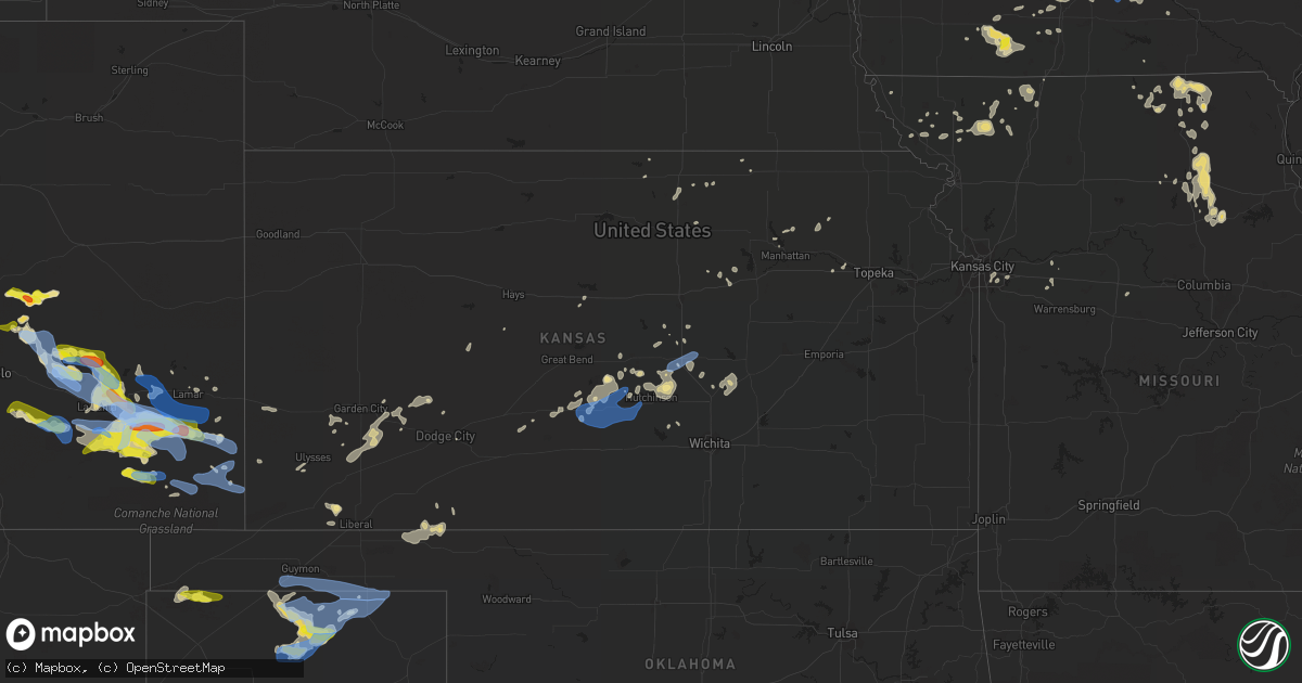
Hail Map in Kansas on July 14, 2020
Get this storm
July 14 map
$229
one time, instant access
Download today. No call, no setup
Keep the $229
Bought the map and want the full workflow? Apply the entire $229 to a subscription within 7 days. None of it is wasted.
Every map, not just this one
This buys you this map. Subscription and you get every map we run, in the markets you choose from a few cities to whole states to nationwide. Plus real-time alerts the moment a storm fires.
Contact data
Name, contact info, occupancy, even credit band for addresses in the footprint. You go from where it hit to who to call.
Become the source they trust
Unlimited branding weather history reports on demand. You already have the documented answer ready for the property owner, and you are the one who showed up with it.
Property data and RoofTrace estimates
Pull up any address you have got, its value and the exact code rules for that jurisdiction, straight from One Click Code. Then RoofTrace estimates the squares, pitch, and roof value, priced the way you price.
Storm reports in Kansas
Kansas
| Date | Description |
|---|---|
| 07/14/20206:58 AM CDT | At 1158 PM CDT, severe thunderstorms were located along a line extending from near Garden City to 10 miles southeast of Meade State Park, moving east at 25 mph. HAZARD...60 mph wind gusts and penny size hail. SOURCE...Radar indicated. IMPACT...Expect damage to roofs, siding, and trees. Locations impacted include... Dodge City, Garden City, Cimarron, Montezuma, Pierceville, Copeland, Ingalls, Ford, Ensign, Charleston, Howell, Wright, Plymell, Kalvesta, The Haggard Elev, Ft. Dodge and Tice. |
| 07/14/20206:38 AM CDT | At 1137 PM CDT, a severe thunderstorm was located 4 miles northeast of Hooker, or 15 miles southwest of Liberal, moving east at 35 mph. HAZARD...60 mph wind gusts and quarter size hail. SOURCE...Automated weather equipment. At 1131 PM CDT, automated weather equipment recorded a 61 mph wind gust at Liberal Municipal Airport. IMPACT...Minor damage to roofs, siding, and trees is possible. Hail damage to vehicles is expected. Locations impacted include... Beaver, Hooker, Tyrone, Forgan, Baker, Adams, Mocane, Turpin and Floris. |
| 07/14/20206:07 AM CDT | At 1107 PM CDT, severe thunderstorms were located along a line extending from 8 miles northeast of Ulysses to 11 miles northwest of Hooker, moving east at 20 mph. HAZARD...60 mph wind gusts and quarter size hail. SOURCE...Radar indicated. IMPACT...Hail damage to vehicles is expected. Expect wind damage to roofs, siding, and trees. Locations impacted include... Ulysses, Hugoton, Moscow, Ryus, Cave, Hickok, Woods and Feterita. |
| 07/14/20206:03 AM CDT | At 1103 PM CDT, a severe thunderstorm was located near Woods, moving east at 25 mph. HAZARD...60 mph wind gusts and quarter size hail. SOURCE...Radar indicated. IMPACT...Hail damage to vehicles is expected. Expect wind damage to roofs, siding, and trees. Locations impacted include... Kismet, Woods, Cave and Hayne. |
| 07/14/20205:37 AM CDT | At 1035 PM CDT, severe thunderstorms were located along a line extending from 4 miles south of Wilburton to 8 miles northwest of Texhoma, moving east at 35 mph. HAZARD...60 mph wind gusts. SOURCE...Automated weather equipment. At 1025 PM CDT, automated weather equipment recorded a 61 mph wind gust 12 miles northwest of Eva. IMPACT...Minor damage to roofs, siding, and trees is possible. Locations impacted include... Guymon, Hooker, Goodwell, Texhoma, Tyrone, Optima, Hardesty, Eva, Hough, Baker and Adams. |
| 07/14/20205:03 AM CDT | At 1003 PM CDT, a severe thunderstorm was located very near Tyrone, or 9 miles southwest of Liberal, moving northeast at 25 mph. HAZARD...60 mph wind gusts and quarter size hail. SOURCE...Radar indicated. IMPACT...Hail damage to vehicles is expected. Expect wind damage to roofs, siding, and trees. Locations impacted include... Liberal and Hayne. |
| 07/14/20202:59 AM CDT | At 758 PM CDT, severe thunderstorms were located along a line extending from 8 miles northwest of Goodwell to 12 miles southeast of Texhoma to 8 miles east of Sunray, moving east at 40 mph. HAZARD...70 mph wind gusts and quarter size hail. SOURCE...Radar indicated. IMPACT...Expect some tree damage. Damage is likely to mobile homes, roofs, and outbuildings. Hail damage to vehicles is expected. Locations impacted include... Guymon, Perryton, Spearman, Hooker, Goodwell, Gruver, Optima, Hardesty, Wolf Creek Park, Adams, Farnsworth, Boyd, Waka, Floris, Pringle, Morse, Bryans Corner, Baker, Turpin and Balko. |
| 07/14/20202:42 AM CDT | A local report indicates 60 MPH wind near HILLSBORO |
| 07/14/20202:13 AM CDT | Semi-trailers blown off i-135 near exit 60. |
| 07/14/20202:13 AM CDT | Power poles downed. |
| 07/14/20202:12 AM CDT | Trees downed with multiple power outages. |
| 07/14/20202:11 AM CDT | A local report indicates 68 MPH wind near MCPHERSON AIRPORT |
| 07/14/20202:06 AM CDT | A local report indicates 58 MPH wind near MCPHERSON AIRPORT |
| 07/14/20201:58 AM CDT | Trees downed in town. |
| 07/14/20201:50 AM CDT | Large tree downed. Via kake-tv on social media. Time estimated from peak wind at hutchinson airport. |
| 07/14/20201:49 AM CDT | Numerous tree limbs down. |
| 07/14/20201:05 AM CDT | Delayed report: damage to a barn / outbuilding and trees down. |
| 07/14/202012:05 AM CDT | Delayed report: damage to a barn / outbuilding and trees down. |
| 07/13/202011:33 PM CDT | Mesonet station sauk1 satanta. |
| 07/13/202011:31 PM CDT | Awos station klbl liberal. |
| 07/13/202011:00 PM CDT | At 400 AM CDT, severe thunderstorms were located along a line extending from near Little River to 8 miles east of Sterling to 5 miles southwest of Nickerson, moving east at 45 mph. HAZARD...60 mph wind gusts. SOURCE...Radar indicated. IMPACT...Expect damage to roofs, siding, and trees. Locations impacted include... Hutchinson, Mcpherson, Lyons, South Hutchinson, Sterling, Inman, Buhler, Nickerson, Little River, Windom, Willowbrook, Mcpherson Airport and Hutchinson Airport.This includes Interstate 135 near Mile Marker 61. |
| 07/13/202010:57 PM CDT | Mesonet station svuk1 moscow. |
| 07/13/202010:23 PM CDT | Mesonet station cglk1 cimarron. |
| 07/13/202010:22 PM CDT | At 321 AM CDT, severe thunderstorms were located along a line extending from 10 miles north of Claflin to 6 miles southwest of Ellinwood, moving east at 40 mph. HAZARD...70 mph wind gusts and nickel size hail. SOURCE...Radar indicated. IMPACT...Expect considerable tree damage. Damage is likely to mobile homes, roofs, and outbuildings. Locations impacted include... Lyons, Sterling, Kanopolis, Little River, Chase, Holyrood, Bushton, Geneseo, Alden, Lorraine, Raymond, Frederick, Silica, Kanopolis Lake and Kanopolis State Park. |
| 07/13/202010:17 PM CDT | Mesonet station cw8810 elkhart. |
| 07/13/20209:55 PM CDT | At 255 AM CDT, severe thunderstorms were located along a line extending from near Milberger to 6 miles south of Albert, moving east at 40 mph. HAZARD...60 mph wind gusts and penny size hail. SOURCE...Radar indicated. IMPACT...Expect damage to roofs, siding, and trees. Locations impacted include... Great Bend, Hoisington, Ellinwood, Claflin, Pawnee Rock, Albert, Olmitz, Galatia, Susank, Great Bend Airport, Cheyenne Bottoms and Odin. |
| 07/13/20209:12 PM CDT | At 212 AM CDT, severe thunderstorms were located along a line extending from 6 miles southeast of Natoma to near Russell to 5 miles west of Milberger, moving east at 40 mph. HAZARD...60 mph wind gusts and penny size hail. SOURCE...Radar indicated. IMPACT...Expect damage to roofs, siding, and trees. Locations impacted include... Russell, Lucas, Gorham, Luray, Dorrance, Milberger, Bunker Hill, Paradise, Waldo, Wilson State Park, Wilson Lake and Russell Airport.This includes Interstate 70 between Mile Markers 175 and 204. |
| 07/13/20208:39 PM CDT | At 138 AM CDT, a severe thunderstorm was located near Ness City, moving southeast at 20 mph. HAZARD...60 mph wind gusts and half dollar size hail. SOURCE...Radar indicated. IMPACT...Hail damage to vehicles is expected. Expect wind damage to roofs, siding, and trees. Locations impacted include... Ness City, Bazine, McCracken, Alexander and Brownell. |
All States Impacted by Hail Map on July 14, 2020
Cities Impacted by Hail Map on July 14, 2020
- Monticello, MS
- Heber Springs, AR
- Sanford, ME
- Alfred, ME
- Kennebunk, ME
- Mcpherson, KS
- Gruver, TX
- Mount Hope, KS
- Titonka, IA
- Buffalo Center, IA
- Albia, IA
- Boyceville, WI
- Wheeler, WI
- Colfax, WI
- Ames, IA
- Boone, IA
- Hooker, OK
- Griffithville, AR
- Searcy, AR
- Ferryville, WI
- Centerville, IA
- Wakefield, RI
- Narragansett, RI
- West Kingston, RI
- Kingston, RI
- Kennebunkport, ME
- Biddeford, ME
- Freeport, IL
- Merrill, WI
- Wausau, WI
- Athens, WI
- Memphis, MO
- St John, KS
- Cimarron, KS
- Jetmore, KS
- Melrose, WI
- Black River Falls, WI
- Reserve, LA
- Edgard, LA
- Garyville, LA
- Olney Springs, CO
- Ordway, CO
- Sugar City, CO
- Coatsville, MO
- Glenwood, MO
- Lancaster, MO
- Radcliffe, IA
- Hubbard, IA
- Buhler, KS
- Grimes, IA
- Granger, IA
- Johnston, IA
- Queen City, MO
- Ramah, CO
- Rush, CO
- Calhan, CO
- Yoder, CO
- Peyton, CO
- Perryton, TX
- Neillsville, WI
- Winterset, IA
- Osceola, IA
- Indianola, IA
- New Virginia, IA
- Saint Charles, IA
- Peru, IA
- Truro, IA
- Hugoton, KS
- Bloomer, WI
- Bunker Hill, KS
- Dorrance, KS
- Madison, MO
- Holliday, MO
- Las Animas, CO
- South Hadley, MA
- Holyoke, MA
- Livingston, AL
- Baker, FL
- Sublette, KS
- Windom, KS
- Marquette, KS
- Englewood, KS
- Story City, IA
- Alden, KS
- Raymond, KS
- Stanberry, MO
- Morse, TX
- Ettrick, WI
- Blair, WI
- Taylor, WI
- Ulysses, KS
- Atmore, AL
- Clearfield, IA
- Novelty, MO
- Leonard, MO
- Clarence, MO
- Macon, MO
- Atlanta, MO
- La Plata, MO
- Anabel, MO
- Cairo, MO
- Dothan, AL
- Benton, IA
- Shannon City, IA
- Diagonal, IA
- Mount Ayr, IA
- Lenox, IA
- Copeland, KS
- Ridgeway, MO
- Grant City, MO
- Hatfield, MO
- Eagleville, MO
- Martinsville, MO
- Edgemont, SD
- Clifton Park, NY
- Madisonville, LA
- Agenda, KS
- Spearman, TX
- Lance Creek, WY
- Gulfport, MS
- Somers, CT
- Ellington, CT
- McCracken, KS
- Black Earth, WI
- Garden City, KS
- Texhoma, OK
- Ingalls, KS
- Dallas Center, IA
- Polk City, IA
- Ankeny, IA
- Des Moines, IA
- West Des Moines, IA
- Madrid, IA
- Urbandale, IA
- Windsor Heights, IA
- Woodward, IA
- Clive, IA
- Waukee, IA
- Jewell, IA
- Gilbert, IA
- Hinsdale, NH
- Warwick, MA
- Winchester, NH
- Northfield, MA
- Vernon, VT
- Kim, CO
- Pritchett, CO
- East Hampstead, NH
- Danville, NH
- Sandown, NH
- Edgerton, WI
- Stoughton, WI
- Burrton, KS
- Inman, KS
- Nickerson, KS
- Hutchinson, KS
- Syracuse, KS
- Dalhart, TX
- Felt, OK
- Boone, CO
- Walsh, CO
- Spring Green, WI
- Plain, WI
- Colorado Springs, CO
- Sylvia, KS
- Stafford, KS
- La Junta, CO
- Aurora, KS
- Thomasville, AL
- Dickinson, AL
- Stinnett, TX
- Sunray, TX
- Uriah, AL
- Manhattan, KS
- Sheldon, WI
- Fort Lauderdale, FL
- Portland, AR
- Montrose, AR
- Chicopee, MA
- Lone Rock, WI
- Sterling, KS
- Lyons, KS
- Lakin, KS
- Satanta, KS
- Pierceville, KS
- Rocky Ford, CO
- Arlington, CO
- Cheraw, CO
- Blakely, GA
- Saucier, MS
- Biloxi, MS
- Belle Fourche, SD
- Rolling Fork, MS
- Novinger, MO
- Green Castle, MO
- Moundridge, KS
- Canton, KS
- Milo, IA
- Pleasantville, IA
- Lacona, IA
- Ashford, CT
- Storrs Mansfield, CT
- Tingley, IA
- Hudson, KS
- Ballston Spa, NY
- Weldon, IA
- Hardesty, OK
- Samson, AL
- Tolland, CT
- Excello, MO
- Jacksonville, MO
- Moberly, MO
- Gate, OK
- Grinnell, IA
- Topeka, KS
- Goodwell, OK
- Guymon, OK
- Melcher Dallas, IA
- Downing, MO
- Milton, WI
- Meade, KS
- Forgan, OK
- Bazine, KS
- Hastings, MN
- West Chesterfield, NH
- Bay Saint Louis, MS
- Allison, IA
- Skidmore, MO
- Lexington, MO
- Galva, KS
- Hasty, CO
- Carlisle, IA
- Ackworth, IA
- North Berwick, ME
- Sully, IA
- Reasnor, IA
- Albany, MO
- New Cambria, MO
- Granada, CO
- Knoxville, IA
- Corning, IA
- Gravity, IA
- King City, MO
- Guilford, MO
- Darlington, MO
- Lindsborg, KS
- Ellsworth, IA
- Bevier, MO
- Junction City, WI
- Milladore, WI
- Arpin, WI
- Assaria, KS
- Muscoda, WI
- Falun, KS
- Delray Beach, FL
- Merrillan, WI
- Hampton, MN
- Farmington, MN
- Thayer, IA
- Greentop, MO
- Wells, ME
- Kansas City, MO
- Saint David, AZ
- Florence, MA
- Easthampton, MA
- Northampton, MA
- Wilmot, AR
- Pass Christian, MS
- Mobile, AL
- Lebanon, ME
- Berwick, ME
- Haverhill, IA
- Laurel, IA
- Robertsdale, AL
- Peabody, KS
- Heidelberg, MS
- Shubuta, MS
- Saunderstown, RI
- Exeter, RI
- Hanover, KS
- Bernardston, MA
- Colrain, MA
- Springfield, MA
- Two Buttes, CO
- Argyle, WI
- Knapp, WI
- Unionville, MO
- Diamondhead, MS
- Ogden, IA
- Milton, FL
- Palm City, FL
- Indiantown, FL
- Stuart, FL
- Long Beach, MS
- Gays Mills, WI
- Solomon, KS
- Osseo, WI
- Augusta, WI
- Jupiter, FL
- Nashua, NH
- Downing, WI
- Glenwood City, WI
- Walton, KS
- Newton, KS
- Merrimack, NH
- Bouton, IA
- Lucas, IA
- Liberty Center, IA
- Mathis, TX
- Hixton, WI
- Humbird, WI
- Alma Center, WI
- Craig, MO
- Pittsville, WI
- Vesper, WI
- Livonia, MO
- Holly, CO
- Bedford, NH
- Onaga, KS
- McRae, AR
- Columbia, IA
- Hamilton, IA
- Brashear, MO
- Hurdland, MO
- Baring, MO
- Courtland, KS
- Creston, IA
- Scandia, KS
- Belleville, KS
- Concordia, KS
- Cowarts, AL
- Blue River, WI
- Boscobel, WI
- Lake View, IA
- North Kingstown, RI
- Lake Worth, FL
- Boynton Beach, FL
- Dodge City, KS
- Wright, KS
- Harvey, IA
- Lamar, CO
- Rockford, IA
- Marble Rock, IA
- Mayview, MO
- Haven, KS
- Saco, ME
- Fountain, CO
- Westmoreland, KS
- Marion, KS
- Kirksville, MO
- Gibbs, MO
- McClave, CO
- Monroe, WI
- Maitland, MO
- Hartford, AL
- Slocomb, AL
- Forest City, IA
- McFall, MO
- Abilene, KS
- Talmage, KS
- Kellogg, IA
- Callao, MO
- Pecatonica, IL
- Ridott, IL
- Barnard, MO
- Bolckow, MO
- Haddam, KS
- Clifton, KS
- Texhoma, TX
- Stratford, TX
- Pompano Beach, FL
- Dermott, AR
- Enfield, CT
- Otley, IA
- Monroe, IA
- Odessa, MO
- Atkinson, NH
- Bethany, MO
- Denver, MO
- Shaw, MS
- Lovilia, IA
- Bussey, IA
- Blue Springs, MO
- Lees Summit, MO
- Eufaula, AL
- Randall, IA
- Newton, IA
- Formoso, KS
- Mitchellville, IA
- Altoona, IA
- Pleasant Hill, IA
- Runnells, IA
- Prairie City, IA
- Rock Port, MO
- Jackson, AL
- Arcadia, WI
- Murray, IA
- Fowler, CO
- Afton, IA
- Olsburg, KS
- Crescent City, FL
- Greensburg, LA
- Kinston, AL
- Hartford, IA
- Pella, IA
- Cornell, WI
- Grand River, IA
- Gentry, MO
- Holt, FL
- Moore Haven, FL
- Abbyville, KS
- Manter, KS
- Eudora, AR
- Mound City, MO
- Chapman, KS
- Hamburg, AR
- Colfax, IA
- Wiley, CO
- Pelham, NH
- Salem, NH
- Lewis, KS
- Silver Creek, MS
- Rosendale, MO
- Cleveland, MS
- Avoca, WI
- Hollenberg, KS
- Fowler, KS
- Fredericksburg, IA
- Sumner, IA
- Jamestown, RI
- Newport, RI
- Middletown, RI
- East Greenwich, RI
- Macksville, KS
- Springfield, CO
- Amherst, NH
- Fillmore, MO
- Pine Hill, AL
- Lower Peach Tree, AL
- Maple Hill, KS
- Paxico, KS
- Chase, KS
- Jacksonville, FL
- West Palm Beach, FL
- Pittsview, AL
- Clayton, AL
- Viroqua, WI
- Prole, IA
- Saint Marys, IA
- Collins, IA
- Green City, MO
- Maryville, MO
- Hughesville, MO
- Sedalia, MO
- West Warwick, RI
- Coventry, RI
- Mingo, IA
- Brattleboro, VT
- West Halifax, VT
- Booker, TX
- Balko, OK
- Chariton, IA
- Plevna, KS
- Arlington, KS
- Partridge, KS
- Turon, KS
- Hudson, NH
- Litchfield, NH
- Stafford Springs, CT
- Stanhope, IA
- Prescott, WI
- Warwick, RI
- Vernon Rockville, CT
- Cohoes, NY
- Waterford, NY
- Rexford, NY
- Fall Creek, WI
- Boyd, WI
- Fairchild, WI
- Stanley, WI
- Manzanola, CO
- Crowley, CO
- Model, CO
- Vilas, CO


