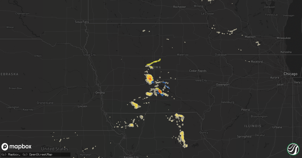
Hail Map on July 14, 2020
Get this storm
July 14 map
$229
one time, instant access
Download today. No call, no setup
Keep the $229
Bought the map and want the full workflow? Apply the entire $229 to a subscription within 7 days. None of it is wasted.
Every map, not just this one
This buys you this map. Subscription and you get every map we run, in the markets you choose from a few cities to whole states to nationwide. Plus real-time alerts the moment a storm fires.
Contact data
Name, contact info, occupancy, even credit band for addresses in the footprint. You go from where it hit to who to call.
Become the source they trust
Unlimited branding weather history reports on demand. You already have the documented answer ready for the property owner, and you are the one who showed up with it.
Property data and RoofTrace estimates
Pull up any address you have got, its value and the exact code rules for that jurisdiction, straight from One Click Code. Then RoofTrace estimates the squares, pitch, and roof value, priced the way you price.
States Impacted by Hail Map on July 14, 2020
Storm reports
Mississippi
| Date | Description |
|---|---|
| 07/14/20203:50 PM CDT | Pictures showing multiple snapped and split large trees near the intersection of east street and ms highway 14 were relayed via local media on twitter. Several fell acr |
| 07/14/20202:24 PM CDT | Waterspout that originated over the bayou la croix and catahoula creek confluence moved onshore on ireland street...causing minor structural damage to 5 houses. |
| 07/14/20202:20 PM CDT | One tree and powerline down. Kgpt measured wind gust of 48 mph near the time of the damage report. |
| 07/13/20209:12 PM CDT | At 212 PM CDT, a severe thunderstorm was located over Portland, or 11 miles north of Wilmot, moving southeast at 10 mph. HAZARD...60 mph wind gusts and penny size hail. SOURCE...Radar indicated. IMPACT...Expect damage to roofs, siding, and trees. Locations impacted include... Eudora, Portland, Montrose and Parkdale. |
Vermont
| Date | Description |
|---|---|
| 07/14/20207:31 AM CDT | At 1231 PM EDT, a severe thunderstorm was located over Northfield, or 8 miles northwest of Orange, moving southeast at 15 mph. HAZARD...60 mph wind gusts and quarter size hail. SOURCE...Radar indicated. IMPACT...Expect wind damage to trees and power lines. Minor hail damage to vehicles is possible. Locations impacted include... Amherst, Greenfield, Orange, Athol, Montague, Barre, Northfield, Hardwick, Bernardston, Leverett, Erving, Shutesbury, Gill, Pelham, Royalston, Petersham, New Salem, Wendell and Warwick. |
| 07/14/20206:35 AM CDT | At 1134 AM EDT, a severe thunderstorm was located over Leyden, or near Greenfield, moving southeast at 20 mph. HAZARD...60 mph wind gusts and quarter size hail. SOURCE...Radar indicated. IMPACT...Expect wind damage to trees and power lines. Minor hail damage to vehicles is possible. Locations impacted include... Amherst, Greenfield, Deerfield, Montague, Hadley, Sunderland, Hatfield, Northfield, Bernardston, Buckland, Conway, Shelburne, Leverett, Erving, Shutesbury, Colrain, Gill, Whately, Pelham and Charlemont. |
| 07/13/202011:54 PM CDT | At 453 AM EDT, severe thunderstorms were located along a line extending from 8 miles west of Piermont to 14 miles southwest of Haverhill to 9 miles northeast of Hanover to near Enfield, moving northeast at 20 mph. HAZARD...60 mph wind gusts and quarter size hail. SOURCE...Radar indicated. IMPACT...Hail damage to vehicles is expected. Expect wind damage to roofs, siding, and trees. Locations impacted include... Lebanon, Hanover, Haverhill, Enfield, Canaan, Groton, Piermont, Lyme, Benton, Dorchester, Wentworth, Orford, Orange and Rumney. |
Oklahoma
| Date | Description |
|---|---|
| 07/14/20206:25 AM CDT | At 1124 PM CDT, severe thunderstorms were located along a line extending from 12 miles south of Deerfield to near Baker, moving east at 35 mph. HAZARD...60 mph wind gusts and quarter size hail. SOURCE...Radar indicated. IMPACT...Hail damage to vehicles is expected. Expect wind damage to roofs, siding, and trees. Locations impacted include... Liberal, Sublette, Satanta, Montezuma, Pierceville, Kismet, Copeland, Ingalls, Charleston, Meade State Park, Missler, Plymell, Tice, Hayne and Plains. |
| 07/13/202010:30 PM CDT | A local report indicates 61 MPH wind near 12 NE EVA |
| 07/13/20208:20 PM CDT | A local report indicates 62 MPH wind near 2 E GOODWELL |
| 07/13/20208:20 PM CDT | Half of a roof blown off of a mobile home. Some 6 inch diameter tree limbs downed. |
Texas
| Date | Description |
|---|---|
| 07/14/202012:35 AM CDT | At 535 PM CDT, a severe thunderstorm was located 10 miles southeast of Felt, or 19 miles south of Boise City, moving east at 15 mph. HAZARD...60 mph wind gusts and quarter size hail. SOURCE...Radar indicated. IMPACT...Minor damage to roofs, siding, and trees is possible. Hail damage to vehicles is expected. Locations impacted include... Griggs. |
| 07/13/20209:27 PM CDT | Net covering removed from game pens. |
| 07/13/20209:25 PM CDT | Roofs of several hog buildings partially blown off at cr24 3 miles north of fm2711 |
| 07/13/20209:11 PM CDT | Roof of hay barn partially blown off |
| 07/13/20208:41 PM CDT | A local report indicates 63 MPH wind near 1 NW PALO DURO RESERVOI |
| 07/13/20208:38 PM CDT | A local report indicates 60 MPH wind near 1 NW PALO DURO RESERVOI |
| 07/13/20208:35 PM CDT | A peak wind gust of 67 mph was recorded at 8:35 pm cdt. Another wind gust of 60 mph was recorded five minutes prior at 8:30 pm cdt. This gust was generated by shallow.. |
| 07/13/20208:18 PM CDT | Power pole half knocked over at 5th and front |
| 07/13/20208:09 PM CDT | Social media report with pictures of damage to grain bins and fences with two large trees downed |
| 07/13/20208:02 PM CDT | The efu tornado touched down in open country around 7 miles west-northwest of gruver and was on the ground for about 4 minutes and around 1.3 miles as it moved east-sou |
New York
| Date | Description |
|---|---|
| 07/14/20201:48 PM CDT | Trees and wires down. |
| 07/14/20201:24 PM CDT | Trees down. Two poles snapped. Wires sparking. Kashmiri terrace and cherry lane. |
| 07/14/20201:24 PM CDT | Trees and wires down. |
| 07/14/20201:24 PM CDT | Trees down. Wires sparking. |
| 07/13/20209:34 PM CDT | At 233 PM EDT, a severe thunderstorm was located over Clifton Park, moving southeast at 25 mph. HAZARD...60 mph wind gusts and quarter size hail. SOURCE...Radar indicated with confirmed reports of wind damage in the Clifton Park area via county dispatchers. IMPACT...Hail damage to vehicles is expected. Expect wind damage to roofs, siding, and trees. Locations impacted include... Albany, Troy, Clifton Park, Cohoes, Watervliet, Rensselaer, Colonie, Latham, Delmar, Niskayuna, Menands, Green Island, Waterford, Round Lake, Loudonville, Country Knolls, Center Brunswick, Alplaus, Wyantskill and East Glenville. |
| 07/13/20209:10 PM CDT | At 209 PM EDT, a severe thunderstorm was located near Round Lake, or 7 miles north of Clifton Park, moving south at 20 mph. HAZARD...60 mph wind gusts and quarter size hail. SOURCE...Radar indicated. IMPACT...Hail damage to vehicles is expected. Expect wind damage to roofs, siding, and trees. Locations impacted include... Clifton Park, Niskayuna, Milton, Ballston Spa, Round Lake, Alplaus, Country Knolls, North Ballston Spa, East Glenville, Burnt Hills, Halfmoon, Malta, Charlton, Maltaville, Malta Ridge, Groom Corners, Glenridge, Willow Glen, Coons and Garrison Manor. |
| 07/13/20209:00 PM CDT | At 200 PM EDT, a severe thunderstorm was located near Mechanicville, moving east at 20 mph. HAZARD...60 mph wind gusts and quarter size hail. SOURCE...Radar indicated. IMPACT...Hail damage to vehicles is expected. Expect wind damage to roofs, siding, and trees. Locations impacted include... Saratoga Springs, Mechanicville, Hoosick Falls, Cambridge, Hoosick, Lee, White Creek, Easton, Stillwater, Schaghticoke, Valley Falls, Deans Corners, Schaghticoke Hill, Center White Creek, Hoosick Junction, Petersburg Junction, Johnsonville, Willow Glen, Coons and Wayville. |
Iowa
| Date | Description |
|---|---|
| 07/14/20206:20 PM CDT | Spotter reported quarter sized hail north of boone. |
| 07/14/20206:00 AM CDT | At 1100 PM CDT, a severe thunderstorm was located 9 miles east of Lenox, or 12 miles northwest of Mount Ayr, moving east at 25 mph. HAZARD...60 mph wind gusts and quarter size hail. SOURCE...Radar indicated. IMPACT...Hail damage to vehicles is expected. Expect wind damage to roofs, siding, and trees. Locations impacted include... Diagonal, Tingley, Arispe and Shannon City. |
| 07/14/20204:35 AM CDT | At 935 PM CDT, a severe thunderstorm was located over Melcher-Dallas, or 10 miles southwest of Knoxville, moving southeast at 20 mph. HAZARD...Golf ball size hail and 60 mph wind gusts. SOURCE...Radar indicated. IMPACT...People and animals outdoors will be injured. Expect hail damage to roofs, siding, windows, and vehicles. Expect wind damage to roofs, siding, and trees. Locations impacted include... Melcher-Dallas, Bussey, Williamson, Hamilton and Marysville. |
| 07/14/20204:20 AM CDT | At 919 PM CDT, a severe thunderstorm was located 7 miles south of Pella, moving southeast at 20 mph. HAZARD...60 mph wind gusts and nickel size hail. SOURCE...Radar indicated. IMPACT...Expect damage to roofs, siding, and trees. Locations impacted include... Oskaloosa, Pella, Eddyville, Lake Red Rock, Beacon, University Park, Bussey, Harvey, Leighton, Hamilton and Pella Municipal Airport. |
| 07/14/20204:09 AM CDT | At 909 PM CDT, a severe thunderstorm was located 8 miles southwest of Pleasantville, or 10 miles southeast of Indianola, moving southeast at 15 mph. HAZARD...60 mph wind gusts and penny size hail. SOURCE...Radar indicated. IMPACT...Expect damage to roofs, siding, and trees. Locations impacted include... Melcher-Dallas, Milo, Lacona and Sandyville. |
| 07/14/20203:56 AM CDT | At 855 PM CDT, a severe thunderstorm was located near Lake Red Rock, or near Pella, moving southeast at 25 mph. HAZARD...60 mph wind gusts and nickel size hail. SOURCE...Radar indicated. IMPACT...Expect damage to roofs, siding, and trees. Locations impacted include... Pella, Monroe and Pella Municipal Airport. |
| 07/14/20203:40 AM CDT | At 839 PM CDT, a severe thunderstorm was located near Indianola, moving east at 30 mph. HAZARD...Ping pong ball size hail and 60 mph wind gusts. SOURCE...Radar indicated. IMPACT...People and animals outdoors will be injured. Expect hail damage to roofs, siding, windows, and vehicles. Expect wind damage to roofs, siding, and trees. Locations impacted include... Indianola, Pella, Pleasantville, Lake Red Rock, Hartford, Ackworth, Swan, Sandyville, Elk Rock State Park and Pella Municipal Airport. |
| 07/14/20203:36 AM CDT | At 836 PM CDT, a severe thunderstorm was located near Monroe, or 8 miles southwest of Newton, moving east at 40 mph. HAZARD...60 mph wind gusts and penny size hail. SOURCE...Radar indicated. IMPACT...Expect damage to roofs, siding, and trees. Locations impacted include... Pella, Monroe, Prairie City, Sully, Lynnville, Reasnor and Prairie City Krohn Airport. |
| 07/14/20202:55 AM CDT | At 754 PM CDT, a severe thunderstorm was located over Urbandale, moving southeast at 15 mph. HAZARD...60 mph wind gusts and half dollar size hail. SOURCE...Radar indicated. IMPACT...Hail damage to vehicles is expected. Expect wind damage to roofs, siding, and trees. Locations impacted include... Des Moines, West Des Moines, Ankeny, Urbandale, Johnston, Clive, Altoona, Waukee, Norwalk, Pleasant Hill, Grimes, Windsor Heights, Saylorville, Southridge Mall, Jordan Creek Town Center, Merle Hay Mall, Iowa Events Center, Iowa State Fairgrounds, Principal Park and Des Moines Int'l Airport.This includes the following highways... Interstate 35 between mile markers 64 and 72, and between milemarkers 87 and 89. Interstate 80 between mile markers 117 and 140. Interstate 235 between mile markers 1 and 14. |
| 07/14/20202:16 AM CDT | At 716 PM CDT, a severe thunderstorm was located over Saylorville Lake, or near Grimes, moving southeast at 20 mph. HAZARD...60 mph wind gusts and quarter size hail. SOURCE...Radar indicated. IMPACT...Hail damage to vehicles is expected. Expect wind damage to roofs, siding, and trees. Locations impacted include... Des Moines, Ankeny, Urbandale, Johnston, Altoona, Grimes, Windsor Heights, Bondurant, Polk City, Saylorville, Granger, Principal Park, Drake Stadium And Knapp Center, Saylorville Lake, Merle Hay Mall, Iowa Events Center, Weh-Weh-Neh-Kee State Park, Margo Frankel Woods State Park and Ankeny Regional Airport.This includes the following highways... Interstate 35 between mile markers 87 and 93. Interstate 80 between mile markers 128 and 140. Interstate 235 between mile markers 6 and 14. |
| 07/14/20201:56 AM CDT | At 656 PM CDT, a severe thunderstorm was located 11 miles northeast of Roland, or 13 miles west of Eldora, moving east at 40 mph. HAZARD...60 mph wind gusts and quarter size hail. SOURCE...Radar indicated. IMPACT...Hail damage to vehicles is expected. Expect wind damage to roofs, siding, and trees. Locations impacted include... Eldora, Hubbard, Wellsburg, Radcliffe, Union, Steamboat Rock, New Providence, Whitten, Garden City, Owasa, Pine Lake State Park, Eldora Municipal Airport and Drake Airport. |
| 07/14/20201:33 AM CDT | At 632 PM CDT, a severe thunderstorm was located near Story City, or 14 miles north of Ames, moving northeast at 20 mph. HAZARD...60 mph wind gusts and half dollar size hail. SOURCE...Radar indicated. IMPACT...Hail damage to vehicles is expected. Expect wind damage to roofs, siding, and trees. Locations impacted include... Jewell Junction, Ellsworth and Randall. This includes Interstate 35 between mile markers 127 and 135. |
| 07/14/20201:10 AM CDT | At 609 PM CDT, a severe thunderstorm was located near Boone, moving east at 20 mph. HAZARD...60 mph wind gusts and quarter size hail. SOURCE...Radar indicated. IMPACT...Hail damage to vehicles is expected. Expect wind damage to roofs, siding, and trees. Locations impacted include... Ames, Story City, Gilbert and Randall. |
| 07/13/20209:45 PM CDT | Krls radio relayed public pictures hail just larger than quarters. |
| 07/13/20209:21 PM CDT | Emergency relayed widespread crop damage including being stripped and or blown over from roughly the marion and warren county lines east to 20th pl and mckimber st. Add |
| 07/13/20209:09 PM CDT | Public relayed picture of large tree branches down... Likely 6 inches in diameter or greater. |
| 07/13/20208:58 PM CDT | Iowa dot reported downed trees near/just west of sandyville along highway 92. Time estimated from radar. |
| 07/13/20208:47 PM CDT | Iowa dot relayed report of stop sign blown over at highway 163 exit on the west side of monroe. |
| 07/13/20208:45 PM CDT | Trees down along highway 92 near mm 140. Time estimated by radar. |
| 07/13/20208:43 PM CDT | Iowa dot relayed report of stop sign blown over at highway 163 ext on west side of monroe. Time estimated from radar. |
| 07/13/20208:20 PM CDT | Large tree damaged near 22nd and ashworth. |
| 07/13/20208:15 PM CDT | All the corn near beaver drive and hwy 415 has been flattened in the same direction. |
| 07/13/20208:13 PM CDT | Delayed report - on grand in wdm between 8th and 4th - large trees down... Power lines down... And traffic signal blown down. |
| 07/13/20208:07 PM CDT | Public calls in report. |
| 07/13/20208:00 PM CDT | Damage to several large trees. |
| 07/13/20207:57 PM CDT | A local report indicates 1.00 inch wind near 2 SSW ANKENY |
| 07/13/20207:45 PM CDT | Several reports of trees blown down in the camp dodge area along 70th. |
| 07/13/20207:45 PM CDT | . |
| 07/13/20207:45 PM CDT | Via social media. |
| 07/13/20207:44 PM CDT | Via social media. |
| 07/13/20207:15 PM CDT | Power lines down. Via social media. Time estimated. |
| 07/13/20207:10 PM CDT | Tree down in road. Via social media. Time estimated. |
| 07/13/20207:05 PM CDT | Trees down in des moines beaverdale neighborhood. Time estimated. |
Minnesota
| Date | Description |
|---|---|
| 07/14/20207:38 AM CDT | Time estimated from radar. |
| 07/14/20207:33 AM CDT | A local report indicates 1.00 inch wind near 3 E VERMILLION |
New Hampshire
| Date | Description |
|---|---|
| 07/14/20203:27 PM CDT | A local report indicates 1.00 inch wind near 2 SW DANVILLE |
| 07/14/20202:29 PM CDT | A local report indicates 1.00 inch wind near 3 W LITCHFIELD |
| 07/14/20202:22 PM CDT | Down branches also reported. |
| 07/14/20202:20 PM CDT | Time estimated from radar. |
| 07/14/202011:15 AM CDT | Person reports hail between 1.25-1.5in... Beginning at 12:15. |
| 07/14/20206:49 AM CDT | At 1149 AM EDT, severe thunderstorms were located along a line extending from near Chesterfield to near Swanzey, moving southeast at 20 mph. HAZARD...60 mph wind gusts and quarter size hail. SOURCE...Radar indicated. IMPACT...Hail damage to vehicles is expected. Expect wind damage to roofs, siding, and trees. Locations impacted include... Keene, Swanzey, Winchester, Richmond, Hinsdale, Westmoreland and Chesterfield. |
| 07/13/202011:40 PM CDT | At 439 AM EDT, a severe thunderstorm was located over Post Mills, moving northeast at 10 mph. HAZARD...60 mph wind gusts and quarter size hail. SOURCE...Radar indicated. IMPACT...Minor hail damage to vehicles is possible. Expect wind damage to trees and powerlines. Locations impacted include... West Fairlee, Bradford, Thetford, Thetford Hill State Park, Thetford Center, Fairlee, Vershire, Newbury Village, Strafford, Newbury, Thetford Hill, South Vershire, Bradford Center, West Fairlee Center, Ely, Post Mills and South Newbury. |
| 07/13/202011:19 PM CDT | At 418 AM EDT, a severe thunderstorm was located over Lebanon, moving northeast at 20 mph. HAZARD...60 mph wind gusts and quarter size hail. SOURCE...Radar indicated. IMPACT...Hail damage to vehicles is expected. Expect wind damage to roofs, siding, and trees. Locations impacted include... Lebanon, Grafton, Hanover, Enfield, Canaan, Grantham, Lyme, Cornish, Dorchester, Orange and Plainfield.This includes Interstate 89 between mile markers 47 and 60. |
Arizona
| Date | Description |
|---|---|
| 07/14/20204:30 PM CDT | Spotter reported a few medium sized mesquite branches were snapped from thunderstorm winds. |
| 07/14/202012:23 AM CDT | At 523 PM MST, a severe thunderstorm was located near Bisbee-Douglas Airport, or 9 miles west of Douglas, moving southeast at 10 mph. HAZARD...60 mph wind gusts and quarter size hail. SOURCE...Radar indicated. IMPACT...Hail damage to vehicles is expected. Expect wind damage to roofs, siding, and trees. Locations impacted include... Douglas, Bisbee-Douglas Airport and Pirtleville. This includes the following highways... Route 80 between mile markers 354 and 373. Route 191 between mile markers 1 and 9. |
| 07/13/20209:08 PM CDT | At 207 PM MST, a severe thunderstorm was located near Kartchner Caverns State Park, or near Benson, moving northeast at 10 mph. HAZARD...60 mph wind gusts and quarter size hail. SOURCE...Radar indicated. IMPACT...Hail damage to vehicles is expected. Expect wind damage to roofs, siding, and trees. Locations impacted include... Benson, St. David and Kartchner Caverns State Park. This includes the following highways... Interstate 10 between mile markers 307 and 311. Route 80 between mile markers 293 and 304. Route 90 between mile markers 292 and 299. |
Connecticut
| Date | Description |
|---|---|
| 07/14/202012:25 PM CDT | A local report indicates 1.00 inch wind near ELLINGTON |
| 07/14/202012:20 PM CDT | A local report indicates 1.00 inch wind near ELLINGTON |
| 07/14/202012:20 PM CDT | Tree down on hoffman road |
| 07/14/202012:20 PM CDT | Tree down on hutton road |
| 07/14/20207:05 AM CDT | At 1204 PM EDT, a severe thunderstorm was located over Northampton, moving south at 15 mph. HAZARD...Ping pong ball size hail and 60 mph wind gusts. SOURCE...Radar indicated. IMPACT...Expect wind damage to trees and power lines. Minor hail damage to vehicles is possible. Locations impacted include... Springfield, Chicopee, Enfield, Westfield, Holyoke, Amherst, Northampton, Agawam, West Springfield, Ludlow, South Hadley, Easthampton, Longmeadow, Suffield, East Longmeadow, Wilbraham, Windsor Locks, Stafford, Somers and Southwick. |
Florida
| Date | Description |
|---|---|
| 07/14/20205:45 PM CDT | Delayed report... Broadcast media relayed reports of an ef0 landspout tornado produced by a thunderstorm outflow boundary collision near haverhill... Fl. The landspout |
| 07/14/20204:43 PM CDT | Communications and electrical services down from a fallen tree in the 600 block of simmons trail. Significant small limbs and debris along sunbridge road from henley ro |
| 07/14/20202:10 AM CDT | At 710 PM EDT, a severe thunderstorm was located over Schall Circle, or near West Palm Beach, moving east at 15 mph. HAZARD...60 mph wind gusts. SOURCE...Radar indicated. IMPACT...Expect damage to roofs, siding, and trees. Locations impacted include... West Palm Beach, Wellington, Jupiter, Palm Beach Gardens and Lake Worth. |
| 07/14/20201:25 AM CDT | At 625 PM EDT, a severe thunderstorm was located over Crescent City, moving south at 5 mph. HAZARD...60 mph wind gusts and penny size hail. SOURCE...Radar indicated. IMPACT...Expect damage to roofs, siding, and trees. Locations impacted include... Crescent City, Pomona Park, Andalusia and Lake Como. |
Kansas
| Date | Description |
|---|---|
| 07/14/20206:58 AM CDT | At 1158 PM CDT, severe thunderstorms were located along a line extending from near Garden City to 10 miles southeast of Meade State Park, moving east at 25 mph. HAZARD...60 mph wind gusts and penny size hail. SOURCE...Radar indicated. IMPACT...Expect damage to roofs, siding, and trees. Locations impacted include... Dodge City, Garden City, Cimarron, Montezuma, Pierceville, Copeland, Ingalls, Ford, Ensign, Charleston, Howell, Wright, Plymell, Kalvesta, The Haggard Elev, Ft. Dodge and Tice. |
| 07/14/20206:38 AM CDT | At 1137 PM CDT, a severe thunderstorm was located 4 miles northeast of Hooker, or 15 miles southwest of Liberal, moving east at 35 mph. HAZARD...60 mph wind gusts and quarter size hail. SOURCE...Automated weather equipment. At 1131 PM CDT, automated weather equipment recorded a 61 mph wind gust at Liberal Municipal Airport. IMPACT...Minor damage to roofs, siding, and trees is possible. Hail damage to vehicles is expected. Locations impacted include... Beaver, Hooker, Tyrone, Forgan, Baker, Adams, Mocane, Turpin and Floris. |
| 07/14/20206:07 AM CDT | At 1107 PM CDT, severe thunderstorms were located along a line extending from 8 miles northeast of Ulysses to 11 miles northwest of Hooker, moving east at 20 mph. HAZARD...60 mph wind gusts and quarter size hail. SOURCE...Radar indicated. IMPACT...Hail damage to vehicles is expected. Expect wind damage to roofs, siding, and trees. Locations impacted include... Ulysses, Hugoton, Moscow, Ryus, Cave, Hickok, Woods and Feterita. |
| 07/14/20206:03 AM CDT | At 1103 PM CDT, a severe thunderstorm was located near Woods, moving east at 25 mph. HAZARD...60 mph wind gusts and quarter size hail. SOURCE...Radar indicated. IMPACT...Hail damage to vehicles is expected. Expect wind damage to roofs, siding, and trees. Locations impacted include... Kismet, Woods, Cave and Hayne. |
| 07/14/20205:37 AM CDT | At 1035 PM CDT, severe thunderstorms were located along a line extending from 4 miles south of Wilburton to 8 miles northwest of Texhoma, moving east at 35 mph. HAZARD...60 mph wind gusts. SOURCE...Automated weather equipment. At 1025 PM CDT, automated weather equipment recorded a 61 mph wind gust 12 miles northwest of Eva. IMPACT...Minor damage to roofs, siding, and trees is possible. Locations impacted include... Guymon, Hooker, Goodwell, Texhoma, Tyrone, Optima, Hardesty, Eva, Hough, Baker and Adams. |
| 07/14/20205:03 AM CDT | At 1003 PM CDT, a severe thunderstorm was located very near Tyrone, or 9 miles southwest of Liberal, moving northeast at 25 mph. HAZARD...60 mph wind gusts and quarter size hail. SOURCE...Radar indicated. IMPACT...Hail damage to vehicles is expected. Expect wind damage to roofs, siding, and trees. Locations impacted include... Liberal and Hayne. |
| 07/14/20202:59 AM CDT | At 758 PM CDT, severe thunderstorms were located along a line extending from 8 miles northwest of Goodwell to 12 miles southeast of Texhoma to 8 miles east of Sunray, moving east at 40 mph. HAZARD...70 mph wind gusts and quarter size hail. SOURCE...Radar indicated. IMPACT...Expect some tree damage. Damage is likely to mobile homes, roofs, and outbuildings. Hail damage to vehicles is expected. Locations impacted include... Guymon, Perryton, Spearman, Hooker, Goodwell, Gruver, Optima, Hardesty, Wolf Creek Park, Adams, Farnsworth, Boyd, Waka, Floris, Pringle, Morse, Bryans Corner, Baker, Turpin and Balko. |
| 07/14/20202:42 AM CDT | A local report indicates 60 MPH wind near HILLSBORO |
| 07/14/20202:13 AM CDT | Semi-trailers blown off i-135 near exit 60. |
| 07/14/20202:13 AM CDT | Power poles downed. |
| 07/14/20202:12 AM CDT | Trees downed with multiple power outages. |
| 07/14/20202:11 AM CDT | A local report indicates 68 MPH wind near MCPHERSON AIRPORT |
| 07/14/20202:06 AM CDT | A local report indicates 58 MPH wind near MCPHERSON AIRPORT |
| 07/14/20201:58 AM CDT | Trees downed in town. |
| 07/14/20201:50 AM CDT | Large tree downed. Via kake-tv on social media. Time estimated from peak wind at hutchinson airport. |
| 07/14/20201:49 AM CDT | Numerous tree limbs down. |
| 07/14/20201:05 AM CDT | Delayed report: damage to a barn / outbuilding and trees down. |
| 07/14/202012:05 AM CDT | Delayed report: damage to a barn / outbuilding and trees down. |
| 07/13/202011:33 PM CDT | Mesonet station sauk1 satanta. |
| 07/13/202011:31 PM CDT | Awos station klbl liberal. |
| 07/13/202011:00 PM CDT | At 400 AM CDT, severe thunderstorms were located along a line extending from near Little River to 8 miles east of Sterling to 5 miles southwest of Nickerson, moving east at 45 mph. HAZARD...60 mph wind gusts. SOURCE...Radar indicated. IMPACT...Expect damage to roofs, siding, and trees. Locations impacted include... Hutchinson, Mcpherson, Lyons, South Hutchinson, Sterling, Inman, Buhler, Nickerson, Little River, Windom, Willowbrook, Mcpherson Airport and Hutchinson Airport.This includes Interstate 135 near Mile Marker 61. |
| 07/13/202010:57 PM CDT | Mesonet station svuk1 moscow. |
| 07/13/202010:23 PM CDT | Mesonet station cglk1 cimarron. |
| 07/13/202010:22 PM CDT | At 321 AM CDT, severe thunderstorms were located along a line extending from 10 miles north of Claflin to 6 miles southwest of Ellinwood, moving east at 40 mph. HAZARD...70 mph wind gusts and nickel size hail. SOURCE...Radar indicated. IMPACT...Expect considerable tree damage. Damage is likely to mobile homes, roofs, and outbuildings. Locations impacted include... Lyons, Sterling, Kanopolis, Little River, Chase, Holyrood, Bushton, Geneseo, Alden, Lorraine, Raymond, Frederick, Silica, Kanopolis Lake and Kanopolis State Park. |
| 07/13/202010:17 PM CDT | Mesonet station cw8810 elkhart. |
| 07/13/20209:55 PM CDT | At 255 AM CDT, severe thunderstorms were located along a line extending from near Milberger to 6 miles south of Albert, moving east at 40 mph. HAZARD...60 mph wind gusts and penny size hail. SOURCE...Radar indicated. IMPACT...Expect damage to roofs, siding, and trees. Locations impacted include... Great Bend, Hoisington, Ellinwood, Claflin, Pawnee Rock, Albert, Olmitz, Galatia, Susank, Great Bend Airport, Cheyenne Bottoms and Odin. |
| 07/13/20209:12 PM CDT | At 212 AM CDT, severe thunderstorms were located along a line extending from 6 miles southeast of Natoma to near Russell to 5 miles west of Milberger, moving east at 40 mph. HAZARD...60 mph wind gusts and penny size hail. SOURCE...Radar indicated. IMPACT...Expect damage to roofs, siding, and trees. Locations impacted include... Russell, Lucas, Gorham, Luray, Dorrance, Milberger, Bunker Hill, Paradise, Waldo, Wilson State Park, Wilson Lake and Russell Airport.This includes Interstate 70 between Mile Markers 175 and 204. |
| 07/13/20208:39 PM CDT | At 138 AM CDT, a severe thunderstorm was located near Ness City, moving southeast at 20 mph. HAZARD...60 mph wind gusts and half dollar size hail. SOURCE...Radar indicated. IMPACT...Hail damage to vehicles is expected. Expect wind damage to roofs, siding, and trees. Locations impacted include... Ness City, Bazine, McCracken, Alexander and Brownell. |
Colorado
| Date | Description |
|---|---|
| 07/14/20205:15 PM CDT | Relayed via media. |
| 07/14/20205:00 PM CDT | Social media post. |
| 07/14/20204:54 PM CDT | Mesonet station co101 082w023 basalt-holland hills. |
| 07/14/20204:24 AM CDT | At 924 PM CDT/824 PM MDT/, severe thunderstorms were located along a line extending from near Lamar to 10 miles northeast of Two Buttes to 12 miles south of Pritchett, moving east at 45 mph. HAZARD...70 mph wind gusts and quarter size hail. SOURCE...Radar indicated. IMPACT...Hail damage to vehicles is expected. Expect considerable tree damage. Wind damage is also likely to mobile homes, roofs, and outbuildings. Locations impacted include... Ulysses, Elkhart, Syracuse, Johnson City, Manter, Coolidge, Kendall, Richfield, The Saunders Elevator and Big Bow. |
| 07/14/20204:09 AM CDT | At 909 PM MDT, a severe thunderstorm was located near Hartman, or 9 miles west of Coolidge, moving east at 25 mph. HAZARD...60 mph wind gusts and penny size hail. SOURCE...Radar indicated. IMPACT...Expect damage to roofs, siding, and trees. Locations impacted include... Holly, Granada, Hartman and Bristol. |
| 07/14/20203:22 AM CDT | At 822 PM MDT, a severe thunderstorm was located near Springfield, moving east at 25 mph. HAZARD...60 mph wind gusts and quarter size hail. SOURCE...Radar indicated. IMPACT...Hail damage to vehicles is expected. Expect wind damage to roofs, siding, and trees. Locations impacted include... Springfield, Walsh, Vilas, Campo, Two Buttes and Stonington. |
| 07/14/20203:08 AM CDT | At 808 PM MDT, a severe thunderstorm was located over Wiley, or near Lamar, moving east at 25 mph. HAZARD...60 mph wind gusts and quarter size hail. SOURCE...Radar indicated. IMPACT...Hail damage to vehicles is expected. Expect wind damage to roofs, siding, and trees. Locations impacted include... Lamar, Holly, Granada, Wiley, Hartman, McClave and Bristol. |
| 07/14/20202:46 AM CDT | At 745 PM MDT, a severe thunderstorm was located 14 miles northwest of Two Buttes Reservoir, or 18 miles south of Lamar, moving east at 30 mph. This is a very dangerous storm. HAZARD...80 mph wind gusts and half dollar size hail. This storm will impact highway 287 south of Lamar. SOURCE...Radar indicated. IMPACT...Flying debris will be dangerous to those caught without shelter. Mobile homes will be heavily damaged. Expect considerable damage to roofs, windows, and vehicles. Extensive tree damage and power outages are likely. Locations impacted include... Lamar, Holly, Granada, Hartman and Bristol. |
| 07/14/20202:42 AM CDT | At 742 PM MDT, a severe thunderstorm was located 15 miles west of Pritchett, or 28 miles west of Springfield, moving east at 40 mph. HAZARD...70 mph wind gusts and half dollar size hail. SOURCE...Radar indicated. IMPACT...Hail damage to vehicles is expected. Expect considerable tree damage. Wind damage is also likely to mobile homes, roofs, and outbuildings. Locations impacted include... Pritchett. |
| 07/14/20202:38 AM CDT | At 738 PM MDT, a severe thunderstorm was located near McClave, or 12 miles west of Lamar, moving east at 30 mph. HAZARD...70 mph wind gusts and quarter size hail. SOURCE...Radar indicated. IMPACT...Hail damage to vehicles is expected. Expect considerable tree damage. Wind damage is also likely to mobile homes, roofs, and outbuildings. Locations impacted include... Lamar, Wiley, McClave and Caddoa. |
| 07/14/20201:56 AM CDT | At 655 PM MDT, a severe thunderstorm was located near Las Animas, or 13 miles northeast of North La Junta, moving east at 40 mph. OTher strong to severe storms were located in southern Bent county. HAZARD...Two inch hail and 70 mph wind gusts. SOURCE...Radar indicated. IMPACT...People and animals outdoors will be injured. Expect hail damage to roofs, siding, windows, and vehicles. Expect considerable tree damage. Wind damage is also likely to mobile homes, roofs, and outbuildings. Locations impacted include... Las Animas, McClave, Higbee, Hasty, John Martin Reservoir, Blue Lake, Fort Lyon and Caddoa. |
| 07/14/20201:40 AM CDT | At 640 PM MDT, a severe thunderstorm was located 8 miles southeast of Higbee, or 22 miles southeast of North La Junta, moving east at 35 mph. HAZARD...Two inch hail and 70 mph wind gusts. SOURCE...Radar indicated. IMPACT...People and animals outdoors will be injured. Expect hail damage to roofs, siding, windows, and vehicles. Expect considerable tree damage. Wind damage is also likely to mobile homes, roofs, and outbuildings. Locations impacted include... Higbee. |
| 07/14/20201:16 AM CDT | At 615 PM MDT, a severe thunderstorm was located near Timpas, or 18 miles southwest of La Junta, moving southeast at 25 mph. HAZARD...Ping pong ball size hail and 60 mph wind gusts. SOURCE...Radar indicated. IMPACT...People and animals outdoors will be injured. Expect hail damage to roofs, siding, windows, and vehicles. Expect wind damage to roofs, siding, and trees. Locations impacted include... Higbee and Timpas. |
| 07/14/20201:00 AM CDT | At 559 PM MDT, a severe thunderstorm was located 12 miles northeast of Boone, or 28 miles east of Pueblo, moving southeast at 25 mph. HAZARD...Golf ball size hail and 60 mph wind gusts. SOURCE...Radar indicated. IMPACT...People and animals outdoors will be injured. Expect hail damage to roofs, siding, windows, and vehicles. Expect wind damage to roofs, siding, and trees. Additional information: A tornadic storm was also located over eastern Crowley county, and this storm was moving southeast. Locations impacted include... Crowley. |
| 07/14/202012:27 AM CDT | At 526 PM MDT, a severe thunderstorm was located 16 miles north of Delhi, or 32 miles west of La Junta, moving east at 25 mph. HAZARD...60 mph wind gusts and half dollar size hail. SOURCE...Radar indicated. IMPACT...Hail damage to vehicles is expected. Expect wind damage to roofs, siding, and trees. Locations impacted include... Timpas. |
| 07/14/202012:18 AM CDT | At 517 PM MDT, a severe thunderstorm was located 13 miles south of Truckton, or 30 miles northeast of Pueblo, moving east at 25 mph. HAZARD...70 mph wind gusts and ping pong ball size hail. SOURCE...Radar indicated. IMPACT...People and animals outdoors will be injured. Expect hail damage to roofs, siding, windows, and vehicles. Expect considerable tree damage. Wind damage is also likely to mobile homes, roofs, and outbuildings. Locations impacted include... Ordway, Olney Springs, Sugar City and Crowley. |
| 07/14/202012:06 AM CDT | At 506 PM MDT, a severe thunderstorm was located 19 miles south of Avondale, or 27 miles southeast of Pueblo, moving east at 25 mph. HAZARD...60 mph wind gusts and half dollar size hail. SOURCE...Radar indicated. IMPACT...Hail damage to vehicles is expected. Expect wind damage to roofs, siding, and trees. This severe thunderstorm will remain over mainly rural areas of southeastern Pueblo County. |
| 07/13/202011:59 PM CDT | At 459 PM MDT, a severe thunderstorm was located near Truckton, or 30 miles east of Colorado Springs, moving east at 15 mph. HAZARD...60 mph wind gusts and half dollar size hail. SOURCE...Radar indicated. IMPACT...Hail damage to vehicles is expected. Expect wind damage to roofs, siding, and trees. Locations impacted include... Hanover, Truckton and Rush. |
| 07/13/202011:29 PM CDT | At 428 PM MDT, a severe thunderstorm was located near Yoder, or 34 miles east of Colorado Springs, moving southeast at 15 mph. HAZARD...Ping pong ball size hail and 60 mph wind gusts. SOURCE...Radar indicated. IMPACT...People and animals outdoors will be injured. Expect hail damage to roofs, siding, windows, and vehicles. Expect wind damage to roofs, siding, and trees. Locations impacted include... Truckton, Yoder and Rush. |
| 07/13/202011:13 PM CDT | At 413 PM MDT, a severe thunderstorm was located near Yoder, or 28 miles east of Colorado Springs, moving east at 15 mph. HAZARD...Ping pong ball size hail and 60 mph wind gusts. SOURCE...Radar indicated. IMPACT...People and animals outdoors will be injured. Expect hail damage to roofs, siding, windows, and vehicles. Expect wind damage to roofs, siding, and trees. Locations impacted include... Truckton and Yoder. |
| 07/13/202010:59 PM CDT | At 358 PM MDT, a severe thunderstorm was located over Rush, or 34 miles southwest of Limon, moving northeast at 10 mph. HAZARD...Ping pong ball size hail and 60 mph wind gusts. SOURCE...Radar indicated. IMPACT...People and animals outdoors will be injured. Expect hail damage to roofs, siding, windows, and vehicles. Expect wind damage to roofs, siding, and trees. Locations impacted include... Rush. |
| 07/13/202010:58 PM CDT | At 357 PM MDT, a severe thunderstorm was located 6 miles east of Rush, or 31 miles southwest of Limon, moving east at 25 mph. HAZARD...Golf ball size hail and 60 mph wind gusts. SOURCE...Radar indicated. IMPACT...Expect damage to roofs, siding, and trees. People and animals outdoors will be injured. Expect hail damage to roofs, siding, windows, and vehicles. Locations impacted include... Kutch and Punkin Center. |
| 07/13/202010:50 PM CDT | At 349 PM MDT, a severe thunderstorm was located near Ellicott, or 20 miles east of Colorado Springs, moving east at 10 mph. HAZARD...60 mph wind gusts and half dollar size hail. SOURCE...Radar indicated. IMPACT...Hail damage to vehicles is expected. Expect wind damage to roofs, siding, and trees. Locations impacted include... Ellicott. |
| 07/13/20209:17 PM CDT | Asos station kspd 8 s springfield. |
| 07/13/20208:04 PM CDT | Reported via social media. |
| 07/13/20208:00 PM CDT | Time estimated. Touched down in south field. |
| 07/13/20208:00 PM CDT | Location approximated. |
| 07/13/20208:00 PM CDT | Tornado touch down. |
New Mexico
| Date | Description |
|---|---|
| 07/14/20206:36 PM CDT | Dunken raws. |
Rhode Island
| Date | Description |
|---|---|
| 07/14/20202:19 PM CDT | A local report indicates 1.25 inch wind near SOUTH KINGSTOWN |
| 07/14/20202:00 PM CDT | Large tree down in the area of newport harbor... Large branches with power outages on easton beach and area of bellevue avenue. |
| 07/14/20201:30 PM CDT | Large branches down on williamsburg drive |
| 07/14/20201:15 PM CDT | Large tree down on windermere road |
| 07/13/20209:30 PM CDT | At 230 PM EDT, a severe thunderstorm was located over Sprague, or near Norwich, moving southeast at 15 mph. HAZARD...Quarter size hail. SOURCE...Radar indicated. IMPACT...Minor damage to vehicles is possible. This severe thunderstorm will be near... Lisbon around 240 PM EDT. Norwich around 245 PM EDT. Preston around 250 PM EDT. Gales Ferry around 300 PM EDT. Ledyard Center around 305 PM EDT. Groton and Ledyard around 315 PM EDT. |
Arkansas
| Date | Description |
|---|---|
| 07/13/202010:15 PM CDT | At 315 PM CDT, a severe thunderstorm was located over Wilmot, moving southeast at 10 mph. HAZARD...60 mph wind gusts and quarter size hail. SOURCE...Radar indicated. IMPACT...Hail damage to vehicles is expected. Expect wind damage to roofs, siding, and trees. This severe thunderstorm will remain over mainly rural areas of southwestern Chicot and southeastern Ashley Counties, northeastern Morehouse, northeastern East Carroll, northeastern West Carroll Parishes in northeastern Louisiana and northwestern Issaquena Counties, including the following locations... Kilbourne. |
| 07/13/20209:56 PM CDT | At 256 PM CDT, a severe thunderstorm was located near Snyder, or 14 miles northeast of Hamburg, and is nearly stationary. HAZARD...60 mph wind gusts and penny size hail. SOURCE...Radar indicated. IMPACT...Expect damage to roofs, siding, and trees. This severe thunderstorm will be near... Snyder around 305 PM CDT. Montrose around 345 PM CDT. |
Massachusetts
| Date | Description |
|---|---|
| 07/14/202011:34 AM CDT | Tree down on wires on mount hermon station road blocking road |
| 07/14/202011:25 AM CDT | A local report indicates 1.25 inch wind near SOUTH HADLEY |
| 07/14/202011:20 AM CDT | Large tree down on southbound lane of rte 91 |
| 07/14/202011:15 AM CDT | A local report indicates 1.00 inch wind near SOUTH HADLEY |
| 07/13/202010:06 PM CDT | At 306 PM EDT, a severe thunderstorm was located near Merrimack, moving southeast at 15 mph. HAZARD...60 mph wind gusts and quarter size hail. SOURCE...Radar indicated. IMPACT...Hail damage to vehicles is expected. Expect wind damage to roofs, siding, and trees. Locations impacted include... Nashua, Derry, Merrimack, Salem, Amherst, Litchfield, Hollis, Hudson, Pelham, Londonderry, Atkinson and Windham.This includes Interstate 93 between mile markers 1 and 9. |
| 07/13/20209:37 PM CDT | At 237 PM EDT, severe thunderstorms were located along a line extending from near West Warwick to Narragansett, moving east at 5 mph. HAZARD...60 mph wind gusts and quarter size hail. SOURCE...Radar indicated. IMPACT...Expect wind damage to trees and power lines. Minor hail damage to vehicles is possible. Locations impacted include... Providence, Fall River, Warwick, Cranston, East Providence, Coventry, South Kingstown, West Warwick, North Kingstown, Newport, Bristol, Somerset, Portsmouth, Barrington, Middletown, Narragansett, Swansea, Tiverton, Seekonk and East Greenwich. |
| 07/13/20208:46 PM CDT | At 146 PM EDT, a severe thunderstorm was located over Smithfield, or near Johnston, moving southeast at 15 mph. HAZARD...60 mph wind gusts and quarter size hail. SOURCE...Radar indicated. IMPACT...Expect wind damage to trees and power lines. Minor hail damage to vehicles is possible. Locations impacted include... Providence, Fall River, Warwick, Cranston, Pawtucket, East Providence, Woonsocket, Coventry, Cumberland, North Providence, West Warwick, Johnston, North Kingstown, Bristol, Attleboro, Smithfield, Lincoln, Central Falls, Somerset and Barrington. |
| 07/13/20208:08 PM CDT | At 107 PM EDT, a severe thunderstorm was located over Somers, or near Enfield, moving south at 20 mph. HAZARD...60 mph wind gusts and quarter size hail. SOURCE...Radar indicated. IMPACT...Expect wind damage to trees and power lines. Minor hail damage to vehicles is possible. Locations impacted include... Manchester, Enfield, Glastonbury, Vernon, Mansfield, South Windsor, Windham, Willimantic, Longmeadow, East Longmeadow, Ellington, Tolland, Coventry, Stafford, Somers, East Windsor, Hebron, Monson, Marlborough and Willington. |
Maine
| Date | Description |
|---|---|
| 07/14/20208:54 AM CDT | 1.3 inch hail reported at the intersection of granite and west street. |
| 07/14/20208:54 AM CDT | A local report indicates 1.00 inch wind near BIDDEFORD |
| 07/14/20208:42 AM CDT | Tree down in roadway. Reported at kennebunk road sanford me. |
| 07/14/20207:55 AM CDT | A local report indicates 1.50 inch wind near 3 SE SANFORD |
| 07/14/20207:55 AM CDT | Hundreds of cars damaged at a dealership. Several with broken windows. |
| 07/14/20207:54 AM CDT | A local report indicates 1.00 inch wind near KENNEBUNK |
| 07/14/20207:54 AM CDT | Multiple trees down with damage to houses and mobile home. 3/4 inch hail also reported. Reported at whitcher mill road sanford me. |
| 07/14/20207:50 AM CDT | A local report indicates 1.00 inch wind near 1 SSE SANFORD |
| 07/14/20207:50 AM CDT | Multiple trees down on houses. Reported at new dam road sanford. |
| 07/14/20207:50 AM CDT | Multiple trees down on houses. Reported at winter mills road sanford. |
| 07/14/20205:03 AM CDT | At 1002 AM EDT, a severe thunderstorm was located over Saco, or over Biddeford, moving northeast at 15 mph. HAZARD...60 mph wind gusts and quarter size hail. SOURCE...Radar indicated. IMPACT...Hail damage to vehicles is expected. Expect wind damage to roofs, siding, and trees. Locations impacted include... Portland, South Portland, Westbrook, Saco, Gorham, Cape Elizabeth, Old Orchard Beach, Scarborough and Windham.This includes the following highways... Interstate 295 between mile markers 1 and 8. Interstate 95 between mile markers 37 and 50.This also includes... Higgins Beach, Crescent Beach State Park, and Scarborough BeachState Park. Cushing Island. |
| 07/14/20204:37 AM CDT | At 935 AM EDT, a severe thunderstorm was located over Kennebunk, or near Biddeford, and is nearly stationary. HAZARD...60 mph wind gusts and half dollar size hail. SOURCE...Radar indicated. IMPACT...Hail damage to vehicles is expected. Expect wind damage to roofs, siding, and trees. Locations impacted include... Biddeford, Saco, Kennebunk, Kennebunkport, Old Orchard Beach and Arundel.This includes Interstate 95 between mile markers 26 and 39. This also includes... Fortunes Rock Beach. |
| 07/14/20204:12 AM CDT | At 912 AM EDT, a severe thunderstorm was located near Alfred, moving northeast at 10 mph. HAZARD...Ping pong ball size hail and 60 mph wind gusts. SOURCE...Radar indicated. IMPACT...People and animals outdoors will be injured. Expect hail damage to roofs, siding, windows, and vehicles. Expect wind damage to roofs, siding, and trees. Locations impacted include... Biddeford, Alfred, Sanford, Saco, Kennebunk, Buxton, Hollis, Kennebunkport, Waterboro, Old Orchard Beach, Wells, Lyman, Arundel and Dayton.This includes Interstate 95 between mile markers 24 and 36. |
| 07/14/20203:32 AM CDT | At 832 AM EDT, a severe thunderstorm was located over Lebanon, or near Rochester, moving northeast at 15 mph. HAZARD...60 mph wind gusts and quarter size hail. SOURCE...Radar indicated. IMPACT...Hail damage to vehicles is expected. Expect wind damage to roofs, siding, and trees. Locations impacted include... Alfred, Sanford, Kennebunk, Berwick, Lebanon, Waterboro, Wells, Lyman, Arundel, North Berwick and Shapleigh.This includes Interstate 95 between mile markers 23 and 26. |
Nebraska
| Date | Description |
|---|---|
| 07/14/20207:17 AM CDT | At 1217 AM CDT, a severe thunderstorm was located over Harlan County Dam, or 21 miles north of Phillipsburg, moving east at 35 mph. HAZARD...60 mph wind gusts. SOURCE...Radar indicated. IMPACT...Expect damage to roofs, siding, and trees. Locations impacted include... Smith Center, Franklin, Campbell, Republican City, Upland, Naponee, Bloomington, Riverton, Athol and Harlan County Dam. |
Alabama
| Date | Description |
|---|---|
| 07/13/202011:09 PM CDT | At 409 PM CDT, a severe thunderstorm was located over Mobile Regional Airport, or 6 miles west of Midtown Mobile, moving northwest at 5 mph. HAZARD...60 mph wind gusts. SOURCE...Radar indicated. IMPACT...Expect damage to roofs, siding, and trees. Locations impacted include... Mobile Regional Airport. |
| 07/13/20209:42 PM CDT | At 241 PM CDT, a severe thunderstorm was located over Uriah, or 9 miles southwest of Frisco City, moving south at 10 mph. HAZARD...60 mph wind gusts and nickel size hail. SOURCE...Radar indicated. IMPACT...Expect damage to roofs, siding, and trees. Locations impacted include... Uriah. |
Wisconsin
| Date | Description |
|---|---|
| 07/14/20204:20 PM CDT | Trees on wires in town. Time estimated. |
| 07/14/20204:18 PM CDT | Small trees and large branches down. Time estimated. |
| 07/14/20205:13 AM CDT | At 1013 PM CDT, a severe thunderstorm was located over Spring Green, or 15 miles north of Dodgeville, moving east at 30 mph. HAZARD...60 mph wind gusts and penny size hail. SOURCE...Radar indicated. IMPACT...Expect damage to roofs, siding, and trees. Locations impacted include... Prairie Du Sac, Sauk City, Cross Plains, Mazomanie, Spring Green, Black Earth, Arena and Plain. |
| 07/14/20202:24 AM CDT | At 723 PM CDT, a severe thunderstorm was located 13 miles north of Wisconsin Rapids, moving northeast at 40 mph. HAZARD...60 mph wind gusts and quarter size hail. SOURCE...Radar indicated. IMPACT...Hail damage to vehicles is expected. Expect wind damage to roofs, siding, and trees. This severe thunderstorm will be near... Bevent around 805 PM CDT.Other locations impacted by this severe thunderstorm includeMilladore, Elderon, Pike Lake, Park Ridge, North Star, Blenker,Dancy, Holt, Ellis and Shantytown. |
| 07/14/20202:22 AM CDT | At 721 AM CDT, a severe thunderstorm was located near Farmington, or 14 miles northeast of Northfield, moving east at 30 mph. HAZARD...Half dollar size hail. SOURCE...Radar indicated. IMPACT...Damage to vehicles is expected. Locations impacted include... Cottage Grove, Hastings, Rosemount, Prescott, Hampton, Vermillion, New Trier, Afton State Park and Point Douglas. |
| 07/14/202012:07 AM CDT | At 506 PM CDT, severe thunderstorms were located along a line extending from near Neillsville to near Hatfield to 6 miles north of North Bend, moving east at 40 mph. HAZARD...60 mph wind gusts and quarter size hail. SOURCE...Radar indicated. IMPACT...Hail damage to vehicles is expected. Expect wind damage to roofs, siding, and trees. Severe thunderstorms will be near... Hatfield around 510 PM CDT. Neillsville around 520 PM CDT. Shortville around 525 PM CDT. Black River Falls around 535 PM CDT. Millston around 545 PM CDT.Other locations impacted by these severe thunderstorms includeFranklin, Ballard Road And Pray Avenue, City Point, Wildcat Mound,Shamrock, The Black River Correctional Center and Pigeon CreekCampground. |
| 07/13/202011:14 PM CDT | At 413 PM CDT, severe thunderstorms were located along a line extending from near Stanley to 6 miles northeast of Augusta to Osseo, moving east at 50 mph. HAZARD...60 mph wind gusts and penny size hail. SOURCE...Radar indicated. IMPACT...Expect damage to roofs, siding, and trees. Severe thunderstorms will be near... Owen around 435 PM CDT. Greenwood around 450 PM CDT. Loyal around 455 PM CDT. Abbotsford around 500 PM CDT.Other locations impacted by these severe thunderstorms include CountyK And Capital Road, Chili, Hog Corners, Mead Lake, Highway 73 And 98,Atwood and Tioga. |
| 07/13/202011:10 PM CDT | At 410 PM CDT, a severe thunderstorm was located over Augusta, or 18 miles southeast of Eau Claire, moving east at 45 mph. HAZARD...60 mph wind gusts and penny size hail. SOURCE...Radar indicated. IMPACT...Expect damage to roofs, siding, and trees. Locations impacted include... Augusta, Fall Creek, Fairchild, Ludington, Foster and Lake Eau Claire County Park.This includes Interstate 94 in Wisconsin between mile markers 79 and86. |
| 07/13/20207:27 PM CDT | Multiple trees down and uprooted with power outages. |
Cities Impacted by Hail Map on July 14, 2020
- Monticello, MS
- Heber Springs, AR
- Sanford, ME
- Alfred, ME
- Kennebunk, ME
- Mcpherson, KS
- Gruver, TX
- Mount Hope, KS
- Titonka, IA
- Buffalo Center, IA
- Albia, IA
- Boyceville, WI
- Wheeler, WI
- Colfax, WI
- Ames, IA
- Boone, IA
- Hooker, OK
- Griffithville, AR
- Searcy, AR
- Ferryville, WI
- Centerville, IA
- Wakefield, RI
- Narragansett, RI
- West Kingston, RI
- Kingston, RI
- Kennebunkport, ME
- Biddeford, ME
- Freeport, IL
- Merrill, WI
- Wausau, WI
- Athens, WI
- Memphis, MO
- St John, KS
- Cimarron, KS
- Jetmore, KS
- Melrose, WI
- Black River Falls, WI
- Reserve, LA
- Edgard, LA
- Garyville, LA
- Olney Springs, CO
- Ordway, CO
- Sugar City, CO
- Coatsville, MO
- Glenwood, MO
- Lancaster, MO
- Radcliffe, IA
- Hubbard, IA
- Buhler, KS
- Grimes, IA
- Granger, IA
- Johnston, IA
- Queen City, MO
- Ramah, CO
- Rush, CO
- Calhan, CO
- Yoder, CO
- Peyton, CO
- Perryton, TX
- Neillsville, WI
- Winterset, IA
- Osceola, IA
- Indianola, IA
- New Virginia, IA
- Saint Charles, IA
- Peru, IA
- Truro, IA
- Hugoton, KS
- Bloomer, WI
- Bunker Hill, KS
- Dorrance, KS
- Madison, MO
- Holliday, MO
- Las Animas, CO
- South Hadley, MA
- Holyoke, MA
- Livingston, AL
- Baker, FL
- Sublette, KS
- Windom, KS
- Marquette, KS
- Englewood, KS
- Story City, IA
- Alden, KS
- Raymond, KS
- Stanberry, MO
- Morse, TX
- Ettrick, WI
- Blair, WI
- Taylor, WI
- Ulysses, KS
- Atmore, AL
- Clearfield, IA
- Novelty, MO
- Leonard, MO
- Clarence, MO
- Macon, MO
- Atlanta, MO
- La Plata, MO
- Anabel, MO
- Cairo, MO
- Dothan, AL
- Benton, IA
- Shannon City, IA
- Diagonal, IA
- Mount Ayr, IA
- Lenox, IA
- Copeland, KS
- Ridgeway, MO
- Grant City, MO
- Hatfield, MO
- Eagleville, MO
- Martinsville, MO
- Edgemont, SD
- Clifton Park, NY
- Madisonville, LA
- Agenda, KS
- Spearman, TX
- Lance Creek, WY
- Gulfport, MS
- Somers, CT
- Ellington, CT
- McCracken, KS
- Black Earth, WI
- Garden City, KS
- Texhoma, OK
- Ingalls, KS
- Dallas Center, IA
- Polk City, IA
- Ankeny, IA
- Des Moines, IA
- West Des Moines, IA
- Madrid, IA
- Urbandale, IA
- Windsor Heights, IA
- Woodward, IA
- Clive, IA
- Waukee, IA
- Jewell, IA
- Gilbert, IA
- Hinsdale, NH
- Warwick, MA
- Winchester, NH
- Northfield, MA
- Vernon, VT
- Kim, CO
- Pritchett, CO
- East Hampstead, NH
- Danville, NH
- Sandown, NH
- Edgerton, WI
- Stoughton, WI
- Burrton, KS
- Inman, KS
- Nickerson, KS
- Hutchinson, KS
- Syracuse, KS
- Dalhart, TX
- Felt, OK
- Boone, CO
- Walsh, CO
- Spring Green, WI
- Plain, WI
- Colorado Springs, CO
- Sylvia, KS
- Stafford, KS
- La Junta, CO
- Aurora, KS
- Thomasville, AL
- Dickinson, AL
- Stinnett, TX
- Sunray, TX
- Uriah, AL
- Manhattan, KS
- Sheldon, WI
- Fort Lauderdale, FL
- Portland, AR
- Montrose, AR
- Chicopee, MA
- Lone Rock, WI
- Sterling, KS
- Lyons, KS
- Lakin, KS
- Satanta, KS
- Pierceville, KS
- Rocky Ford, CO
- Arlington, CO
- Cheraw, CO
- Blakely, GA
- Saucier, MS
- Biloxi, MS
- Belle Fourche, SD
- Rolling Fork, MS
- Novinger, MO
- Green Castle, MO
- Moundridge, KS
- Canton, KS
- Milo, IA
- Pleasantville, IA
- Lacona, IA
- Ashford, CT
- Storrs Mansfield, CT
- Tingley, IA
- Hudson, KS
- Ballston Spa, NY
- Weldon, IA
- Hardesty, OK
- Samson, AL
- Tolland, CT
- Excello, MO
- Jacksonville, MO
- Moberly, MO
- Gate, OK
- Grinnell, IA
- Topeka, KS
- Goodwell, OK
- Guymon, OK
- Melcher Dallas, IA
- Downing, MO
- Milton, WI
- Meade, KS
- Forgan, OK
- Bazine, KS
- Hastings, MN
- West Chesterfield, NH
- Bay Saint Louis, MS
- Allison, IA
- Skidmore, MO
- Lexington, MO
- Galva, KS
- Hasty, CO
- Carlisle, IA
- Ackworth, IA
- North Berwick, ME
- Sully, IA
- Reasnor, IA
- Albany, MO
- New Cambria, MO
- Granada, CO
- Knoxville, IA
- Corning, IA
- Gravity, IA
- King City, MO
- Guilford, MO
- Darlington, MO
- Lindsborg, KS
- Ellsworth, IA
- Bevier, MO
- Junction City, WI
- Milladore, WI
- Arpin, WI
- Assaria, KS
- Muscoda, WI
- Falun, KS
- Delray Beach, FL
- Merrillan, WI
- Hampton, MN
- Farmington, MN
- Thayer, IA
- Greentop, MO
- Wells, ME
- Kansas City, MO
- Saint David, AZ
- Florence, MA
- Easthampton, MA
- Northampton, MA
- Wilmot, AR
- Pass Christian, MS
- Mobile, AL
- Lebanon, ME
- Berwick, ME
- Haverhill, IA
- Laurel, IA
- Robertsdale, AL
- Peabody, KS
- Heidelberg, MS
- Shubuta, MS
- Saunderstown, RI
- Exeter, RI
- Hanover, KS
- Bernardston, MA
- Colrain, MA
- Springfield, MA
- Two Buttes, CO
- Argyle, WI
- Knapp, WI
- Unionville, MO
- Diamondhead, MS
- Ogden, IA
- Milton, FL
- Palm City, FL
- Indiantown, FL
- Stuart, FL
- Long Beach, MS
- Gays Mills, WI
- Solomon, KS
- Osseo, WI
- Augusta, WI
- Jupiter, FL
- Nashua, NH
- Downing, WI
- Glenwood City, WI
- Walton, KS
- Newton, KS
- Merrimack, NH
- Bouton, IA
- Lucas, IA
- Liberty Center, IA
- Mathis, TX
- Hixton, WI
- Humbird, WI
- Alma Center, WI
- Craig, MO
- Pittsville, WI
- Vesper, WI
- Livonia, MO
- Holly, CO
- Bedford, NH
- Onaga, KS
- McRae, AR
- Columbia, IA
- Hamilton, IA
- Brashear, MO
- Hurdland, MO
- Baring, MO
- Courtland, KS
- Creston, IA
- Scandia, KS
- Belleville, KS
- Concordia, KS
- Cowarts, AL
- Blue River, WI
- Boscobel, WI
- Lake View, IA
- North Kingstown, RI
- Lake Worth, FL
- Boynton Beach, FL
- Dodge City, KS
- Wright, KS
- Harvey, IA
- Lamar, CO
- Rockford, IA
- Marble Rock, IA
- Mayview, MO
- Haven, KS
- Saco, ME
- Fountain, CO
- Westmoreland, KS
- Marion, KS
- Kirksville, MO
- Gibbs, MO
- McClave, CO
- Monroe, WI
- Maitland, MO
- Hartford, AL
- Slocomb, AL
- Forest City, IA
- McFall, MO
- Abilene, KS
- Talmage, KS
- Kellogg, IA
- Callao, MO
- Pecatonica, IL
- Ridott, IL
- Barnard, MO
- Bolckow, MO
- Haddam, KS
- Clifton, KS
- Texhoma, TX
- Stratford, TX
- Pompano Beach, FL
- Dermott, AR
- Enfield, CT
- Otley, IA
- Monroe, IA
- Odessa, MO
- Atkinson, NH
- Bethany, MO
- Denver, MO
- Shaw, MS
- Lovilia, IA
- Bussey, IA
- Blue Springs, MO
- Lees Summit, MO
- Eufaula, AL
- Randall, IA
- Newton, IA
- Formoso, KS
- Mitchellville, IA
- Altoona, IA
- Pleasant Hill, IA
- Runnells, IA
- Prairie City, IA
- Rock Port, MO
- Jackson, AL
- Arcadia, WI
- Murray, IA
- Fowler, CO
- Afton, IA
- Olsburg, KS
- Crescent City, FL
- Greensburg, LA
- Kinston, AL
- Hartford, IA
- Pella, IA
- Cornell, WI
- Grand River, IA
- Gentry, MO
- Holt, FL
- Moore Haven, FL
- Abbyville, KS
- Manter, KS
- Eudora, AR
- Mound City, MO
- Chapman, KS
- Hamburg, AR
- Colfax, IA
- Wiley, CO
- Pelham, NH
- Salem, NH
- Lewis, KS
- Silver Creek, MS
- Rosendale, MO
- Cleveland, MS
- Avoca, WI
- Hollenberg, KS
- Fowler, KS
- Fredericksburg, IA
- Sumner, IA
- Jamestown, RI
- Newport, RI
- Middletown, RI
- East Greenwich, RI
- Macksville, KS
- Springfield, CO
- Amherst, NH
- Fillmore, MO
- Pine Hill, AL
- Lower Peach Tree, AL
- Maple Hill, KS
- Paxico, KS
- Chase, KS
- Jacksonville, FL
- West Palm Beach, FL
- Pittsview, AL
- Clayton, AL
- Viroqua, WI
- Prole, IA
- Saint Marys, IA
- Collins, IA
- Green City, MO
- Maryville, MO
- Hughesville, MO
- Sedalia, MO
- West Warwick, RI
- Coventry, RI
- Mingo, IA
- Brattleboro, VT
- West Halifax, VT
- Booker, TX
- Balko, OK
- Chariton, IA
- Plevna, KS
- Arlington, KS
- Partridge, KS
- Turon, KS
- Hudson, NH
- Litchfield, NH
- Stafford Springs, CT
- Stanhope, IA
- Prescott, WI
- Warwick, RI
- Vernon Rockville, CT
- Cohoes, NY
- Waterford, NY
- Rexford, NY
- Fall Creek, WI
- Boyd, WI
- Fairchild, WI
- Stanley, WI
- Manzanola, CO
- Crowley, CO
- Model, CO
- Vilas, CO