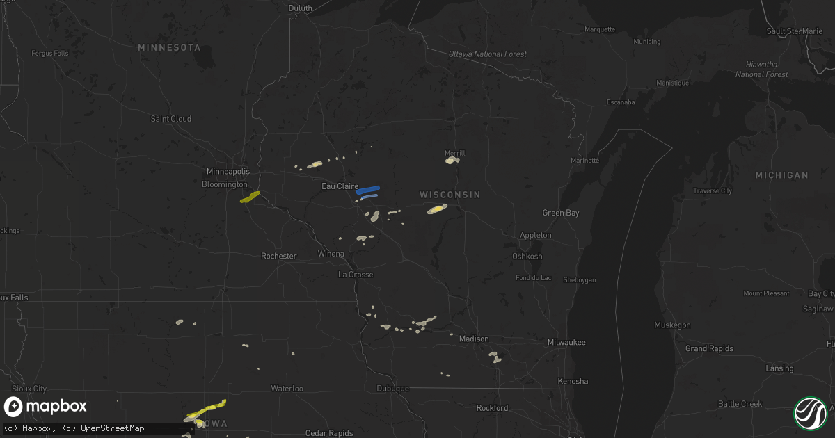
Hail Map in Wisconsin on July 14, 2020
Get this storm
July 14 map
$229
one time, instant access
Download today. No call, no setup
Keep the $229
Bought the map and want the full workflow? Apply the entire $229 to a subscription within 7 days. None of it is wasted.
Every map, not just this one
This buys you this map. Subscription and you get every map we run, in the markets you choose from a few cities to whole states to nationwide. Plus real-time alerts the moment a storm fires.
Contact data
Name, contact info, occupancy, even credit band for addresses in the footprint. You go from where it hit to who to call.
Become the source they trust
Unlimited branding weather history reports on demand. You already have the documented answer ready for the property owner, and you are the one who showed up with it.
Property data and RoofTrace estimates
Pull up any address you have got, its value and the exact code rules for that jurisdiction, straight from One Click Code. Then RoofTrace estimates the squares, pitch, and roof value, priced the way you price.
Storm reports in Wisconsin
Wisconsin
| Date | Description |
|---|---|
| 07/14/20204:20 PM CDT | Trees on wires in town. Time estimated. |
| 07/14/20204:18 PM CDT | Small trees and large branches down. Time estimated. |
| 07/14/20205:13 AM CDT | At 1013 PM CDT, a severe thunderstorm was located over Spring Green, or 15 miles north of Dodgeville, moving east at 30 mph. HAZARD...60 mph wind gusts and penny size hail. SOURCE...Radar indicated. IMPACT...Expect damage to roofs, siding, and trees. Locations impacted include... Prairie Du Sac, Sauk City, Cross Plains, Mazomanie, Spring Green, Black Earth, Arena and Plain. |
| 07/14/20202:24 AM CDT | At 723 PM CDT, a severe thunderstorm was located 13 miles north of Wisconsin Rapids, moving northeast at 40 mph. HAZARD...60 mph wind gusts and quarter size hail. SOURCE...Radar indicated. IMPACT...Hail damage to vehicles is expected. Expect wind damage to roofs, siding, and trees. This severe thunderstorm will be near... Bevent around 805 PM CDT.Other locations impacted by this severe thunderstorm includeMilladore, Elderon, Pike Lake, Park Ridge, North Star, Blenker,Dancy, Holt, Ellis and Shantytown. |
| 07/14/20202:22 AM CDT | At 721 AM CDT, a severe thunderstorm was located near Farmington, or 14 miles northeast of Northfield, moving east at 30 mph. HAZARD...Half dollar size hail. SOURCE...Radar indicated. IMPACT...Damage to vehicles is expected. Locations impacted include... Cottage Grove, Hastings, Rosemount, Prescott, Hampton, Vermillion, New Trier, Afton State Park and Point Douglas. |
| 07/14/202012:07 AM CDT | At 506 PM CDT, severe thunderstorms were located along a line extending from near Neillsville to near Hatfield to 6 miles north of North Bend, moving east at 40 mph. HAZARD...60 mph wind gusts and quarter size hail. SOURCE...Radar indicated. IMPACT...Hail damage to vehicles is expected. Expect wind damage to roofs, siding, and trees. Severe thunderstorms will be near... Hatfield around 510 PM CDT. Neillsville around 520 PM CDT. Shortville around 525 PM CDT. Black River Falls around 535 PM CDT. Millston around 545 PM CDT.Other locations impacted by these severe thunderstorms includeFranklin, Ballard Road And Pray Avenue, City Point, Wildcat Mound,Shamrock, The Black River Correctional Center and Pigeon CreekCampground. |
| 07/13/202011:14 PM CDT | At 413 PM CDT, severe thunderstorms were located along a line extending from near Stanley to 6 miles northeast of Augusta to Osseo, moving east at 50 mph. HAZARD...60 mph wind gusts and penny size hail. SOURCE...Radar indicated. IMPACT...Expect damage to roofs, siding, and trees. Severe thunderstorms will be near... Owen around 435 PM CDT. Greenwood around 450 PM CDT. Loyal around 455 PM CDT. Abbotsford around 500 PM CDT.Other locations impacted by these severe thunderstorms include CountyK And Capital Road, Chili, Hog Corners, Mead Lake, Highway 73 And 98,Atwood and Tioga. |
| 07/13/202011:10 PM CDT | At 410 PM CDT, a severe thunderstorm was located over Augusta, or 18 miles southeast of Eau Claire, moving east at 45 mph. HAZARD...60 mph wind gusts and penny size hail. SOURCE...Radar indicated. IMPACT...Expect damage to roofs, siding, and trees. Locations impacted include... Augusta, Fall Creek, Fairchild, Ludington, Foster and Lake Eau Claire County Park.This includes Interstate 94 in Wisconsin between mile markers 79 and86. |
| 07/13/20207:27 PM CDT | Multiple trees down and uprooted with power outages. |
All States Impacted by Hail Map on July 14, 2020
Cities Impacted by Hail Map on July 14, 2020
- Monticello, MS
- Heber Springs, AR
- Sanford, ME
- Alfred, ME
- Kennebunk, ME
- Mcpherson, KS
- Gruver, TX
- Mount Hope, KS
- Titonka, IA
- Buffalo Center, IA
- Albia, IA
- Boyceville, WI
- Wheeler, WI
- Colfax, WI
- Ames, IA
- Boone, IA
- Hooker, OK
- Griffithville, AR
- Searcy, AR
- Ferryville, WI
- Centerville, IA
- Wakefield, RI
- Narragansett, RI
- West Kingston, RI
- Kingston, RI
- Kennebunkport, ME
- Biddeford, ME
- Freeport, IL
- Merrill, WI
- Wausau, WI
- Athens, WI
- Memphis, MO
- St John, KS
- Cimarron, KS
- Jetmore, KS
- Melrose, WI
- Black River Falls, WI
- Reserve, LA
- Edgard, LA
- Garyville, LA
- Olney Springs, CO
- Ordway, CO
- Sugar City, CO
- Coatsville, MO
- Glenwood, MO
- Lancaster, MO
- Radcliffe, IA
- Hubbard, IA
- Buhler, KS
- Grimes, IA
- Granger, IA
- Johnston, IA
- Queen City, MO
- Ramah, CO
- Rush, CO
- Calhan, CO
- Yoder, CO
- Peyton, CO
- Perryton, TX
- Neillsville, WI
- Winterset, IA
- Osceola, IA
- Indianola, IA
- New Virginia, IA
- Saint Charles, IA
- Peru, IA
- Truro, IA
- Hugoton, KS
- Bloomer, WI
- Bunker Hill, KS
- Dorrance, KS
- Madison, MO
- Holliday, MO
- Las Animas, CO
- South Hadley, MA
- Holyoke, MA
- Livingston, AL
- Baker, FL
- Sublette, KS
- Windom, KS
- Marquette, KS
- Englewood, KS
- Story City, IA
- Alden, KS
- Raymond, KS
- Stanberry, MO
- Morse, TX
- Ettrick, WI
- Blair, WI
- Taylor, WI
- Ulysses, KS
- Atmore, AL
- Clearfield, IA
- Novelty, MO
- Leonard, MO
- Clarence, MO
- Macon, MO
- Atlanta, MO
- La Plata, MO
- Anabel, MO
- Cairo, MO
- Dothan, AL
- Benton, IA
- Shannon City, IA
- Diagonal, IA
- Mount Ayr, IA
- Lenox, IA
- Copeland, KS
- Ridgeway, MO
- Grant City, MO
- Hatfield, MO
- Eagleville, MO
- Martinsville, MO
- Edgemont, SD
- Clifton Park, NY
- Madisonville, LA
- Agenda, KS
- Spearman, TX
- Lance Creek, WY
- Gulfport, MS
- Somers, CT
- Ellington, CT
- McCracken, KS
- Black Earth, WI
- Garden City, KS
- Texhoma, OK
- Ingalls, KS
- Dallas Center, IA
- Polk City, IA
- Ankeny, IA
- Des Moines, IA
- West Des Moines, IA
- Madrid, IA
- Urbandale, IA
- Windsor Heights, IA
- Woodward, IA
- Clive, IA
- Waukee, IA
- Jewell, IA
- Gilbert, IA
- Hinsdale, NH
- Warwick, MA
- Winchester, NH
- Northfield, MA
- Vernon, VT
- Kim, CO
- Pritchett, CO
- East Hampstead, NH
- Danville, NH
- Sandown, NH
- Edgerton, WI
- Stoughton, WI
- Burrton, KS
- Inman, KS
- Nickerson, KS
- Hutchinson, KS
- Syracuse, KS
- Dalhart, TX
- Felt, OK
- Boone, CO
- Walsh, CO
- Spring Green, WI
- Plain, WI
- Colorado Springs, CO
- Sylvia, KS
- Stafford, KS
- La Junta, CO
- Aurora, KS
- Thomasville, AL
- Dickinson, AL
- Stinnett, TX
- Sunray, TX
- Uriah, AL
- Manhattan, KS
- Sheldon, WI
- Fort Lauderdale, FL
- Portland, AR
- Montrose, AR
- Chicopee, MA
- Lone Rock, WI
- Sterling, KS
- Lyons, KS
- Lakin, KS
- Satanta, KS
- Pierceville, KS
- Rocky Ford, CO
- Arlington, CO
- Cheraw, CO
- Blakely, GA
- Saucier, MS
- Biloxi, MS
- Belle Fourche, SD
- Rolling Fork, MS
- Novinger, MO
- Green Castle, MO
- Moundridge, KS
- Canton, KS
- Milo, IA
- Pleasantville, IA
- Lacona, IA
- Ashford, CT
- Storrs Mansfield, CT
- Tingley, IA
- Hudson, KS
- Ballston Spa, NY
- Weldon, IA
- Hardesty, OK
- Samson, AL
- Tolland, CT
- Excello, MO
- Jacksonville, MO
- Moberly, MO
- Gate, OK
- Grinnell, IA
- Topeka, KS
- Goodwell, OK
- Guymon, OK
- Melcher Dallas, IA
- Downing, MO
- Milton, WI
- Meade, KS
- Forgan, OK
- Bazine, KS
- Hastings, MN
- West Chesterfield, NH
- Bay Saint Louis, MS
- Allison, IA
- Skidmore, MO
- Lexington, MO
- Galva, KS
- Hasty, CO
- Carlisle, IA
- Ackworth, IA
- North Berwick, ME
- Sully, IA
- Reasnor, IA
- Albany, MO
- New Cambria, MO
- Granada, CO
- Knoxville, IA
- Corning, IA
- Gravity, IA
- King City, MO
- Guilford, MO
- Darlington, MO
- Lindsborg, KS
- Ellsworth, IA
- Bevier, MO
- Junction City, WI
- Milladore, WI
- Arpin, WI
- Assaria, KS
- Muscoda, WI
- Falun, KS
- Delray Beach, FL
- Merrillan, WI
- Hampton, MN
- Farmington, MN
- Thayer, IA
- Greentop, MO
- Wells, ME
- Kansas City, MO
- Saint David, AZ
- Florence, MA
- Easthampton, MA
- Northampton, MA
- Wilmot, AR
- Pass Christian, MS
- Mobile, AL
- Lebanon, ME
- Berwick, ME
- Haverhill, IA
- Laurel, IA
- Robertsdale, AL
- Peabody, KS
- Heidelberg, MS
- Shubuta, MS
- Saunderstown, RI
- Exeter, RI
- Hanover, KS
- Bernardston, MA
- Colrain, MA
- Springfield, MA
- Two Buttes, CO
- Argyle, WI
- Knapp, WI
- Unionville, MO
- Diamondhead, MS
- Ogden, IA
- Milton, FL
- Palm City, FL
- Indiantown, FL
- Stuart, FL
- Long Beach, MS
- Gays Mills, WI
- Solomon, KS
- Osseo, WI
- Augusta, WI
- Jupiter, FL
- Nashua, NH
- Downing, WI
- Glenwood City, WI
- Walton, KS
- Newton, KS
- Merrimack, NH
- Bouton, IA
- Lucas, IA
- Liberty Center, IA
- Mathis, TX
- Hixton, WI
- Humbird, WI
- Alma Center, WI
- Craig, MO
- Pittsville, WI
- Vesper, WI
- Livonia, MO
- Holly, CO
- Bedford, NH
- Onaga, KS
- McRae, AR
- Columbia, IA
- Hamilton, IA
- Brashear, MO
- Hurdland, MO
- Baring, MO
- Courtland, KS
- Creston, IA
- Scandia, KS
- Belleville, KS
- Concordia, KS
- Cowarts, AL
- Blue River, WI
- Boscobel, WI
- Lake View, IA
- North Kingstown, RI
- Lake Worth, FL
- Boynton Beach, FL
- Dodge City, KS
- Wright, KS
- Harvey, IA
- Lamar, CO
- Rockford, IA
- Marble Rock, IA
- Mayview, MO
- Haven, KS
- Saco, ME
- Fountain, CO
- Westmoreland, KS
- Marion, KS
- Kirksville, MO
- Gibbs, MO
- McClave, CO
- Monroe, WI
- Maitland, MO
- Hartford, AL
- Slocomb, AL
- Forest City, IA
- McFall, MO
- Abilene, KS
- Talmage, KS
- Kellogg, IA
- Callao, MO
- Pecatonica, IL
- Ridott, IL
- Barnard, MO
- Bolckow, MO
- Haddam, KS
- Clifton, KS
- Texhoma, TX
- Stratford, TX
- Pompano Beach, FL
- Dermott, AR
- Enfield, CT
- Otley, IA
- Monroe, IA
- Odessa, MO
- Atkinson, NH
- Bethany, MO
- Denver, MO
- Shaw, MS
- Lovilia, IA
- Bussey, IA
- Blue Springs, MO
- Lees Summit, MO
- Eufaula, AL
- Randall, IA
- Newton, IA
- Formoso, KS
- Mitchellville, IA
- Altoona, IA
- Pleasant Hill, IA
- Runnells, IA
- Prairie City, IA
- Rock Port, MO
- Jackson, AL
- Arcadia, WI
- Murray, IA
- Fowler, CO
- Afton, IA
- Olsburg, KS
- Crescent City, FL
- Greensburg, LA
- Kinston, AL
- Hartford, IA
- Pella, IA
- Cornell, WI
- Grand River, IA
- Gentry, MO
- Holt, FL
- Moore Haven, FL
- Abbyville, KS
- Manter, KS
- Eudora, AR
- Mound City, MO
- Chapman, KS
- Hamburg, AR
- Colfax, IA
- Wiley, CO
- Pelham, NH
- Salem, NH
- Lewis, KS
- Silver Creek, MS
- Rosendale, MO
- Cleveland, MS
- Avoca, WI
- Hollenberg, KS
- Fowler, KS
- Fredericksburg, IA
- Sumner, IA
- Jamestown, RI
- Newport, RI
- Middletown, RI
- East Greenwich, RI
- Macksville, KS
- Springfield, CO
- Amherst, NH
- Fillmore, MO
- Pine Hill, AL
- Lower Peach Tree, AL
- Maple Hill, KS
- Paxico, KS
- Chase, KS
- Jacksonville, FL
- West Palm Beach, FL
- Pittsview, AL
- Clayton, AL
- Viroqua, WI
- Prole, IA
- Saint Marys, IA
- Collins, IA
- Green City, MO
- Maryville, MO
- Hughesville, MO
- Sedalia, MO
- West Warwick, RI
- Coventry, RI
- Mingo, IA
- Brattleboro, VT
- West Halifax, VT
- Booker, TX
- Balko, OK
- Chariton, IA
- Plevna, KS
- Arlington, KS
- Partridge, KS
- Turon, KS
- Hudson, NH
- Litchfield, NH
- Stafford Springs, CT
- Stanhope, IA
- Prescott, WI
- Warwick, RI
- Vernon Rockville, CT
- Cohoes, NY
- Waterford, NY
- Rexford, NY
- Fall Creek, WI
- Boyd, WI
- Fairchild, WI
- Stanley, WI
- Manzanola, CO
- Crowley, CO
- Model, CO
- Vilas, CO


