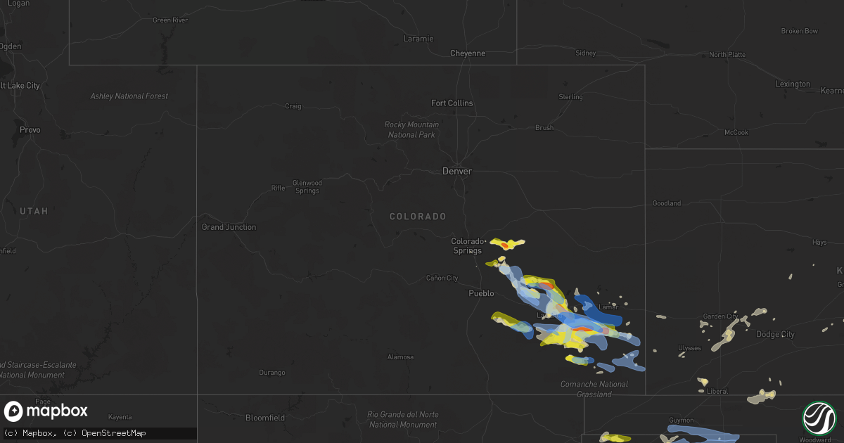
Hail Map in Colorado on July 14, 2020
Get this storm
July 14 map
$229
one time, instant access
Download today. No call, no setup
Keep the $229
Bought the map and want the full workflow? Apply the entire $229 to a subscription within 7 days. None of it is wasted.
Every map, not just this one
This buys you this map. Subscription and you get every map we run, in the markets you choose from a few cities to whole states to nationwide. Plus real-time alerts the moment a storm fires.
Contact data
Name, contact info, occupancy, even credit band for addresses in the footprint. You go from where it hit to who to call.
Become the source they trust
Unlimited branding weather history reports on demand. You already have the documented answer ready for the property owner, and you are the one who showed up with it.
Property data and RoofTrace estimates
Pull up any address you have got, its value and the exact code rules for that jurisdiction, straight from One Click Code. Then RoofTrace estimates the squares, pitch, and roof value, priced the way you price.
Storm reports in Colorado
Colorado
| Date | Description |
|---|---|
| 07/14/20205:15 PM CDT | Relayed via media. |
| 07/14/20205:00 PM CDT | Social media post. |
| 07/14/20204:54 PM CDT | Mesonet station co101 082w023 basalt-holland hills. |
| 07/14/20204:24 AM CDT | At 924 PM CDT/824 PM MDT/, severe thunderstorms were located along a line extending from near Lamar to 10 miles northeast of Two Buttes to 12 miles south of Pritchett, moving east at 45 mph. HAZARD...70 mph wind gusts and quarter size hail. SOURCE...Radar indicated. IMPACT...Hail damage to vehicles is expected. Expect considerable tree damage. Wind damage is also likely to mobile homes, roofs, and outbuildings. Locations impacted include... Ulysses, Elkhart, Syracuse, Johnson City, Manter, Coolidge, Kendall, Richfield, The Saunders Elevator and Big Bow. |
| 07/14/20204:09 AM CDT | At 909 PM MDT, a severe thunderstorm was located near Hartman, or 9 miles west of Coolidge, moving east at 25 mph. HAZARD...60 mph wind gusts and penny size hail. SOURCE...Radar indicated. IMPACT...Expect damage to roofs, siding, and trees. Locations impacted include... Holly, Granada, Hartman and Bristol. |
| 07/14/20203:22 AM CDT | At 822 PM MDT, a severe thunderstorm was located near Springfield, moving east at 25 mph. HAZARD...60 mph wind gusts and quarter size hail. SOURCE...Radar indicated. IMPACT...Hail damage to vehicles is expected. Expect wind damage to roofs, siding, and trees. Locations impacted include... Springfield, Walsh, Vilas, Campo, Two Buttes and Stonington. |
| 07/14/20203:08 AM CDT | At 808 PM MDT, a severe thunderstorm was located over Wiley, or near Lamar, moving east at 25 mph. HAZARD...60 mph wind gusts and quarter size hail. SOURCE...Radar indicated. IMPACT...Hail damage to vehicles is expected. Expect wind damage to roofs, siding, and trees. Locations impacted include... Lamar, Holly, Granada, Wiley, Hartman, McClave and Bristol. |
| 07/14/20202:46 AM CDT | At 745 PM MDT, a severe thunderstorm was located 14 miles northwest of Two Buttes Reservoir, or 18 miles south of Lamar, moving east at 30 mph. This is a very dangerous storm. HAZARD...80 mph wind gusts and half dollar size hail. This storm will impact highway 287 south of Lamar. SOURCE...Radar indicated. IMPACT...Flying debris will be dangerous to those caught without shelter. Mobile homes will be heavily damaged. Expect considerable damage to roofs, windows, and vehicles. Extensive tree damage and power outages are likely. Locations impacted include... Lamar, Holly, Granada, Hartman and Bristol. |
| 07/14/20202:42 AM CDT | At 742 PM MDT, a severe thunderstorm was located 15 miles west of Pritchett, or 28 miles west of Springfield, moving east at 40 mph. HAZARD...70 mph wind gusts and half dollar size hail. SOURCE...Radar indicated. IMPACT...Hail damage to vehicles is expected. Expect considerable tree damage. Wind damage is also likely to mobile homes, roofs, and outbuildings. Locations impacted include... Pritchett. |
| 07/14/20202:38 AM CDT | At 738 PM MDT, a severe thunderstorm was located near McClave, or 12 miles west of Lamar, moving east at 30 mph. HAZARD...70 mph wind gusts and quarter size hail. SOURCE...Radar indicated. IMPACT...Hail damage to vehicles is expected. Expect considerable tree damage. Wind damage is also likely to mobile homes, roofs, and outbuildings. Locations impacted include... Lamar, Wiley, McClave and Caddoa. |
| 07/14/20201:56 AM CDT | At 655 PM MDT, a severe thunderstorm was located near Las Animas, or 13 miles northeast of North La Junta, moving east at 40 mph. OTher strong to severe storms were located in southern Bent county. HAZARD...Two inch hail and 70 mph wind gusts. SOURCE...Radar indicated. IMPACT...People and animals outdoors will be injured. Expect hail damage to roofs, siding, windows, and vehicles. Expect considerable tree damage. Wind damage is also likely to mobile homes, roofs, and outbuildings. Locations impacted include... Las Animas, McClave, Higbee, Hasty, John Martin Reservoir, Blue Lake, Fort Lyon and Caddoa. |
| 07/14/20201:40 AM CDT | At 640 PM MDT, a severe thunderstorm was located 8 miles southeast of Higbee, or 22 miles southeast of North La Junta, moving east at 35 mph. HAZARD...Two inch hail and 70 mph wind gusts. SOURCE...Radar indicated. IMPACT...People and animals outdoors will be injured. Expect hail damage to roofs, siding, windows, and vehicles. Expect considerable tree damage. Wind damage is also likely to mobile homes, roofs, and outbuildings. Locations impacted include... Higbee. |
| 07/14/20201:16 AM CDT | At 615 PM MDT, a severe thunderstorm was located near Timpas, or 18 miles southwest of La Junta, moving southeast at 25 mph. HAZARD...Ping pong ball size hail and 60 mph wind gusts. SOURCE...Radar indicated. IMPACT...People and animals outdoors will be injured. Expect hail damage to roofs, siding, windows, and vehicles. Expect wind damage to roofs, siding, and trees. Locations impacted include... Higbee and Timpas. |
| 07/14/20201:00 AM CDT | At 559 PM MDT, a severe thunderstorm was located 12 miles northeast of Boone, or 28 miles east of Pueblo, moving southeast at 25 mph. HAZARD...Golf ball size hail and 60 mph wind gusts. SOURCE...Radar indicated. IMPACT...People and animals outdoors will be injured. Expect hail damage to roofs, siding, windows, and vehicles. Expect wind damage to roofs, siding, and trees. Additional information: A tornadic storm was also located over eastern Crowley county, and this storm was moving southeast. Locations impacted include... Crowley. |
| 07/14/202012:27 AM CDT | At 526 PM MDT, a severe thunderstorm was located 16 miles north of Delhi, or 32 miles west of La Junta, moving east at 25 mph. HAZARD...60 mph wind gusts and half dollar size hail. SOURCE...Radar indicated. IMPACT...Hail damage to vehicles is expected. Expect wind damage to roofs, siding, and trees. Locations impacted include... Timpas. |
| 07/14/202012:18 AM CDT | At 517 PM MDT, a severe thunderstorm was located 13 miles south of Truckton, or 30 miles northeast of Pueblo, moving east at 25 mph. HAZARD...70 mph wind gusts and ping pong ball size hail. SOURCE...Radar indicated. IMPACT...People and animals outdoors will be injured. Expect hail damage to roofs, siding, windows, and vehicles. Expect considerable tree damage. Wind damage is also likely to mobile homes, roofs, and outbuildings. Locations impacted include... Ordway, Olney Springs, Sugar City and Crowley. |
| 07/14/202012:06 AM CDT | At 506 PM MDT, a severe thunderstorm was located 19 miles south of Avondale, or 27 miles southeast of Pueblo, moving east at 25 mph. HAZARD...60 mph wind gusts and half dollar size hail. SOURCE...Radar indicated. IMPACT...Hail damage to vehicles is expected. Expect wind damage to roofs, siding, and trees. This severe thunderstorm will remain over mainly rural areas of southeastern Pueblo County. |
| 07/13/202011:59 PM CDT | At 459 PM MDT, a severe thunderstorm was located near Truckton, or 30 miles east of Colorado Springs, moving east at 15 mph. HAZARD...60 mph wind gusts and half dollar size hail. SOURCE...Radar indicated. IMPACT...Hail damage to vehicles is expected. Expect wind damage to roofs, siding, and trees. Locations impacted include... Hanover, Truckton and Rush. |
| 07/13/202011:29 PM CDT | At 428 PM MDT, a severe thunderstorm was located near Yoder, or 34 miles east of Colorado Springs, moving southeast at 15 mph. HAZARD...Ping pong ball size hail and 60 mph wind gusts. SOURCE...Radar indicated. IMPACT...People and animals outdoors will be injured. Expect hail damage to roofs, siding, windows, and vehicles. Expect wind damage to roofs, siding, and trees. Locations impacted include... Truckton, Yoder and Rush. |
| 07/13/202011:13 PM CDT | At 413 PM MDT, a severe thunderstorm was located near Yoder, or 28 miles east of Colorado Springs, moving east at 15 mph. HAZARD...Ping pong ball size hail and 60 mph wind gusts. SOURCE...Radar indicated. IMPACT...People and animals outdoors will be injured. Expect hail damage to roofs, siding, windows, and vehicles. Expect wind damage to roofs, siding, and trees. Locations impacted include... Truckton and Yoder. |
| 07/13/202010:59 PM CDT | At 358 PM MDT, a severe thunderstorm was located over Rush, or 34 miles southwest of Limon, moving northeast at 10 mph. HAZARD...Ping pong ball size hail and 60 mph wind gusts. SOURCE...Radar indicated. IMPACT...People and animals outdoors will be injured. Expect hail damage to roofs, siding, windows, and vehicles. Expect wind damage to roofs, siding, and trees. Locations impacted include... Rush. |
| 07/13/202010:58 PM CDT | At 357 PM MDT, a severe thunderstorm was located 6 miles east of Rush, or 31 miles southwest of Limon, moving east at 25 mph. HAZARD...Golf ball size hail and 60 mph wind gusts. SOURCE...Radar indicated. IMPACT...Expect damage to roofs, siding, and trees. People and animals outdoors will be injured. Expect hail damage to roofs, siding, windows, and vehicles. Locations impacted include... Kutch and Punkin Center. |
| 07/13/202010:50 PM CDT | At 349 PM MDT, a severe thunderstorm was located near Ellicott, or 20 miles east of Colorado Springs, moving east at 10 mph. HAZARD...60 mph wind gusts and half dollar size hail. SOURCE...Radar indicated. IMPACT...Hail damage to vehicles is expected. Expect wind damage to roofs, siding, and trees. Locations impacted include... Ellicott. |
| 07/13/20209:17 PM CDT | Asos station kspd 8 s springfield. |
| 07/13/20208:04 PM CDT | Reported via social media. |
| 07/13/20208:00 PM CDT | Time estimated. Touched down in south field. |
| 07/13/20208:00 PM CDT | Tornado touch down. |
| 07/13/20208:00 PM CDT | Location approximated. |
All States Impacted by Hail Map on July 14, 2020
Cities Impacted by Hail Map on July 14, 2020
- Monticello, MS
- Heber Springs, AR
- Sanford, ME
- Alfred, ME
- Kennebunk, ME
- Mcpherson, KS
- Gruver, TX
- Mount Hope, KS
- Titonka, IA
- Buffalo Center, IA
- Albia, IA
- Boyceville, WI
- Wheeler, WI
- Colfax, WI
- Ames, IA
- Boone, IA
- Hooker, OK
- Griffithville, AR
- Searcy, AR
- Ferryville, WI
- Centerville, IA
- Wakefield, RI
- Narragansett, RI
- West Kingston, RI
- Kingston, RI
- Kennebunkport, ME
- Biddeford, ME
- Freeport, IL
- Merrill, WI
- Wausau, WI
- Athens, WI
- Memphis, MO
- St John, KS
- Cimarron, KS
- Jetmore, KS
- Melrose, WI
- Black River Falls, WI
- Reserve, LA
- Edgard, LA
- Garyville, LA
- Olney Springs, CO
- Ordway, CO
- Sugar City, CO
- Coatsville, MO
- Glenwood, MO
- Lancaster, MO
- Radcliffe, IA
- Hubbard, IA
- Buhler, KS
- Grimes, IA
- Granger, IA
- Johnston, IA
- Queen City, MO
- Ramah, CO
- Rush, CO
- Calhan, CO
- Yoder, CO
- Peyton, CO
- Perryton, TX
- Neillsville, WI
- Winterset, IA
- Osceola, IA
- Indianola, IA
- New Virginia, IA
- Saint Charles, IA
- Peru, IA
- Truro, IA
- Hugoton, KS
- Bloomer, WI
- Bunker Hill, KS
- Dorrance, KS
- Madison, MO
- Holliday, MO
- Las Animas, CO
- South Hadley, MA
- Holyoke, MA
- Livingston, AL
- Baker, FL
- Sublette, KS
- Windom, KS
- Marquette, KS
- Englewood, KS
- Story City, IA
- Alden, KS
- Raymond, KS
- Stanberry, MO
- Morse, TX
- Ettrick, WI
- Blair, WI
- Taylor, WI
- Ulysses, KS
- Atmore, AL
- Clearfield, IA
- Novelty, MO
- Leonard, MO
- Clarence, MO
- Macon, MO
- Atlanta, MO
- La Plata, MO
- Anabel, MO
- Cairo, MO
- Dothan, AL
- Benton, IA
- Shannon City, IA
- Diagonal, IA
- Mount Ayr, IA
- Lenox, IA
- Copeland, KS
- Ridgeway, MO
- Grant City, MO
- Hatfield, MO
- Eagleville, MO
- Martinsville, MO
- Edgemont, SD
- Clifton Park, NY
- Madisonville, LA
- Agenda, KS
- Spearman, TX
- Lance Creek, WY
- Gulfport, MS
- Somers, CT
- Ellington, CT
- McCracken, KS
- Black Earth, WI
- Garden City, KS
- Texhoma, OK
- Ingalls, KS
- Dallas Center, IA
- Polk City, IA
- Ankeny, IA
- Des Moines, IA
- West Des Moines, IA
- Madrid, IA
- Urbandale, IA
- Windsor Heights, IA
- Woodward, IA
- Clive, IA
- Waukee, IA
- Jewell, IA
- Gilbert, IA
- Hinsdale, NH
- Warwick, MA
- Winchester, NH
- Northfield, MA
- Vernon, VT
- Kim, CO
- Pritchett, CO
- East Hampstead, NH
- Danville, NH
- Sandown, NH
- Edgerton, WI
- Stoughton, WI
- Burrton, KS
- Inman, KS
- Nickerson, KS
- Hutchinson, KS
- Syracuse, KS
- Dalhart, TX
- Felt, OK
- Boone, CO
- Walsh, CO
- Spring Green, WI
- Plain, WI
- Colorado Springs, CO
- Sylvia, KS
- Stafford, KS
- La Junta, CO
- Aurora, KS
- Thomasville, AL
- Dickinson, AL
- Stinnett, TX
- Sunray, TX
- Uriah, AL
- Manhattan, KS
- Sheldon, WI
- Fort Lauderdale, FL
- Portland, AR
- Montrose, AR
- Chicopee, MA
- Lone Rock, WI
- Sterling, KS
- Lyons, KS
- Lakin, KS
- Satanta, KS
- Pierceville, KS
- Rocky Ford, CO
- Arlington, CO
- Cheraw, CO
- Blakely, GA
- Saucier, MS
- Biloxi, MS
- Belle Fourche, SD
- Rolling Fork, MS
- Novinger, MO
- Green Castle, MO
- Moundridge, KS
- Canton, KS
- Milo, IA
- Pleasantville, IA
- Lacona, IA
- Ashford, CT
- Storrs Mansfield, CT
- Tingley, IA
- Hudson, KS
- Ballston Spa, NY
- Weldon, IA
- Hardesty, OK
- Samson, AL
- Tolland, CT
- Excello, MO
- Jacksonville, MO
- Moberly, MO
- Gate, OK
- Grinnell, IA
- Topeka, KS
- Goodwell, OK
- Guymon, OK
- Melcher Dallas, IA
- Downing, MO
- Milton, WI
- Meade, KS
- Forgan, OK
- Bazine, KS
- Hastings, MN
- West Chesterfield, NH
- Bay Saint Louis, MS
- Allison, IA
- Skidmore, MO
- Lexington, MO
- Galva, KS
- Hasty, CO
- Carlisle, IA
- Ackworth, IA
- North Berwick, ME
- Sully, IA
- Reasnor, IA
- Albany, MO
- New Cambria, MO
- Granada, CO
- Knoxville, IA
- Corning, IA
- Gravity, IA
- King City, MO
- Guilford, MO
- Darlington, MO
- Lindsborg, KS
- Ellsworth, IA
- Bevier, MO
- Junction City, WI
- Milladore, WI
- Arpin, WI
- Assaria, KS
- Muscoda, WI
- Falun, KS
- Delray Beach, FL
- Merrillan, WI
- Hampton, MN
- Farmington, MN
- Thayer, IA
- Greentop, MO
- Wells, ME
- Kansas City, MO
- Saint David, AZ
- Florence, MA
- Easthampton, MA
- Northampton, MA
- Wilmot, AR
- Pass Christian, MS
- Mobile, AL
- Lebanon, ME
- Berwick, ME
- Haverhill, IA
- Laurel, IA
- Robertsdale, AL
- Peabody, KS
- Heidelberg, MS
- Shubuta, MS
- Saunderstown, RI
- Exeter, RI
- Hanover, KS
- Bernardston, MA
- Colrain, MA
- Springfield, MA
- Two Buttes, CO
- Argyle, WI
- Knapp, WI
- Unionville, MO
- Diamondhead, MS
- Ogden, IA
- Milton, FL
- Palm City, FL
- Indiantown, FL
- Stuart, FL
- Long Beach, MS
- Gays Mills, WI
- Solomon, KS
- Osseo, WI
- Augusta, WI
- Jupiter, FL
- Nashua, NH
- Downing, WI
- Glenwood City, WI
- Walton, KS
- Newton, KS
- Merrimack, NH
- Bouton, IA
- Lucas, IA
- Liberty Center, IA
- Mathis, TX
- Hixton, WI
- Humbird, WI
- Alma Center, WI
- Craig, MO
- Pittsville, WI
- Vesper, WI
- Livonia, MO
- Holly, CO
- Bedford, NH
- Onaga, KS
- McRae, AR
- Columbia, IA
- Hamilton, IA
- Brashear, MO
- Hurdland, MO
- Baring, MO
- Courtland, KS
- Creston, IA
- Scandia, KS
- Belleville, KS
- Concordia, KS
- Cowarts, AL
- Blue River, WI
- Boscobel, WI
- Lake View, IA
- North Kingstown, RI
- Lake Worth, FL
- Boynton Beach, FL
- Dodge City, KS
- Wright, KS
- Harvey, IA
- Lamar, CO
- Rockford, IA
- Marble Rock, IA
- Mayview, MO
- Haven, KS
- Saco, ME
- Fountain, CO
- Westmoreland, KS
- Marion, KS
- Kirksville, MO
- Gibbs, MO
- McClave, CO
- Monroe, WI
- Maitland, MO
- Hartford, AL
- Slocomb, AL
- Forest City, IA
- McFall, MO
- Abilene, KS
- Talmage, KS
- Kellogg, IA
- Callao, MO
- Pecatonica, IL
- Ridott, IL
- Barnard, MO
- Bolckow, MO
- Haddam, KS
- Clifton, KS
- Texhoma, TX
- Stratford, TX
- Pompano Beach, FL
- Dermott, AR
- Enfield, CT
- Otley, IA
- Monroe, IA
- Odessa, MO
- Atkinson, NH
- Bethany, MO
- Denver, MO
- Shaw, MS
- Lovilia, IA
- Bussey, IA
- Blue Springs, MO
- Lees Summit, MO
- Eufaula, AL
- Randall, IA
- Newton, IA
- Formoso, KS
- Mitchellville, IA
- Altoona, IA
- Pleasant Hill, IA
- Runnells, IA
- Prairie City, IA
- Rock Port, MO
- Jackson, AL
- Arcadia, WI
- Murray, IA
- Fowler, CO
- Afton, IA
- Olsburg, KS
- Crescent City, FL
- Greensburg, LA
- Kinston, AL
- Hartford, IA
- Pella, IA
- Cornell, WI
- Grand River, IA
- Gentry, MO
- Holt, FL
- Moore Haven, FL
- Abbyville, KS
- Manter, KS
- Eudora, AR
- Mound City, MO
- Chapman, KS
- Hamburg, AR
- Colfax, IA
- Wiley, CO
- Pelham, NH
- Salem, NH
- Lewis, KS
- Silver Creek, MS
- Rosendale, MO
- Cleveland, MS
- Avoca, WI
- Hollenberg, KS
- Fowler, KS
- Fredericksburg, IA
- Sumner, IA
- Jamestown, RI
- Newport, RI
- Middletown, RI
- East Greenwich, RI
- Macksville, KS
- Springfield, CO
- Amherst, NH
- Fillmore, MO
- Pine Hill, AL
- Lower Peach Tree, AL
- Maple Hill, KS
- Paxico, KS
- Chase, KS
- Jacksonville, FL
- West Palm Beach, FL
- Pittsview, AL
- Clayton, AL
- Viroqua, WI
- Prole, IA
- Saint Marys, IA
- Collins, IA
- Green City, MO
- Maryville, MO
- Hughesville, MO
- Sedalia, MO
- West Warwick, RI
- Coventry, RI
- Mingo, IA
- Brattleboro, VT
- West Halifax, VT
- Booker, TX
- Balko, OK
- Chariton, IA
- Plevna, KS
- Arlington, KS
- Partridge, KS
- Turon, KS
- Hudson, NH
- Litchfield, NH
- Stafford Springs, CT
- Stanhope, IA
- Prescott, WI
- Warwick, RI
- Vernon Rockville, CT
- Cohoes, NY
- Waterford, NY
- Rexford, NY
- Fall Creek, WI
- Boyd, WI
- Fairchild, WI
- Stanley, WI
- Manzanola, CO
- Crowley, CO
- Model, CO
- Vilas, CO


