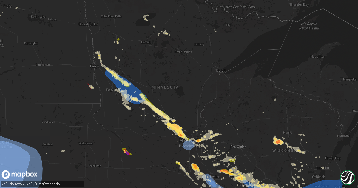
Hail Map in Minnesota on July 13, 2024
Get this storm
July 13 map
$229
one time, instant access
Download today. No call, no setup
Keep the $229
Bought the map and want the full workflow? Apply the entire $229 to a subscription within 7 days. None of it is wasted.
Every map, not just this one
This buys you this map. Subscription and you get every map we run, in the markets you choose from a few cities to whole states to nationwide. Plus real-time alerts the moment a storm fires.
Contact data
Name, contact info, occupancy, even credit band for addresses in the footprint. You go from where it hit to who to call.
Become the source they trust
Unlimited branding weather history reports on demand. You already have the documented answer ready for the property owner, and you are the one who showed up with it.
Property data and RoofTrace estimates
Pull up any address you have got, its value and the exact code rules for that jurisdiction, straight from One Click Code. Then RoofTrace estimates the squares, pitch, and roof value, priced the way you price.
Storm reports in Minnesota
Minnesota
| Date | Description |
|---|---|
| 07/13/20246:51 PM CDT | Asos station krst rochester international airport. |
| 07/13/20246:50 PM CDT | A local report indicates 1.50 inch wind near 5 NNW Nodine |
| 07/13/20246:45 PM CDT | A local report indicates 1.75 inch wind near 5 E Pickwick |
| 07/13/20246:45 PM CDT | Asos station krst rochester international airport. |
| 07/13/20246:37 PM CDT | Several large limbs down... Including on a house. |
| 07/13/20246:30 PM CDT | A local report indicates 1.00 inch wind near 3 E Winger |
| 07/13/20246:29 PM CDT | Downed power poles. |
| 07/13/20246:15 PM CDT | Delayed report... Time estimated from radar. Large tree across road. Several pine trees snapped. |
| 07/13/20246:15 PM CDT | Delayed report... Time estimated from radar. 6 to 8 trees down in the southeast bay of waktins lake. |
| 07/13/20245:52 PM CDT | A local report indicates 2.00 inch wind near Goodview |
| 07/13/20245:47 PM CDT | A local report indicates 2.00 inch wind near 1 SE Rollingstone |
| 07/13/20245:47 PM CDT | A local report indicates 2.00 inch wind near 1 W Minnesota City |
| 07/13/20245:35 PM CDT | Relayed via county official. |
| 07/13/20245:08 PM CDT | A local report indicates 1.75 inch wind near 6 N Nodine |
| 07/13/20245:05 PM CDT | A local report indicates 1.00 inch wind near Trempealeau |
| 07/13/20245:05 PM CDT | Found at 510 pm with time it fell estimated based on radar. |
| 07/13/20245:00 PM CDT | A local report indicates 1.00 inch wind near Pickwick |
| 07/13/20244:59 PM CDT | Reported by a trained spotter near the intersection of 270th st. E and 59th ave. |
| 07/13/20244:58 PM CDT | A local report indicates 1.25 inch wind near 2 SE Le Center |
| 07/13/20244:40 PM CDT | A local report indicates 1.00 inch wind near 1 NE Le Center |
| 07/13/20244:33 PM CDT | A local report indicates 1.75 inch wind near 2 SSE Nerstrand |
| 07/13/20243:10 PM CDT | Observation at station mn069. |
| 07/13/20248:00 AM CDT | Caller noted a lot of corn damage associated with hail. |
| 07/13/20248:00 AM CDT | A local report indicates 1.00 inch wind near Wood Lake |
| 07/13/20241:25 AM CDT | Report from mping: 3-inch tree limbs broken; power poles broken with times estimated based on radar. |
| 07/13/20241:20 AM CDT | Delayed report... Time estimated from radar. Several tree branches down and lawn furniture knocked over. Report via x. |
| 07/13/20241:18 AM CDT | Personal weather station measurement from state agency meteorologist. |
| 07/13/20241:15 AM CDT | Delayed report... Time estimated from radar. Large tree snapped near the st. Paul cathedral. Report via x. |
| 07/13/20241:12 AM CDT | A local report indicates 62 MPH wind near MSP Airport |
| 07/13/20241:10 AM CDT | Relayed via metro skywarn. |
| 07/13/20241:10 AM CDT | Delayed report... Time estimated from radar. Large trees |
| 07/13/20241:08 AM CDT | Measured from personal weather station. |
| 07/13/20241:05 AM CDT | Delayed report with photos of a few large trees and numerous branches down near wolfe park. Time estimated from radar. |
| 07/13/20241:05 AM CDT | Photo of uprooted 16-21 inch round tree at minneapolis college of art and design. |
| 07/13/20241:05 AM CDT | Delayed report... Time estimated from radar. Large trees between 12-24 inch diameter |
| 07/13/20241:00 AM CDT | Delayed report... Time estimated from radar. Large trees down near the intersection of laurel ave and rhode island ave. Report via x. |
| 07/13/202412:45 AM CDT | Delayed report... Time estimated from radar. Large tree |
| 07/13/202412:42 AM CDT | Delayed report: photo with a few large hail stones between 2.0 and 2.25 inches in diameter on a measuring tape. Time estimated via radar. |
| 07/13/202412:35 AM CDT | Delayed report: caller reported several branches down on property ranging from 4 to 8 inches in diameter. |
| 07/13/202412:30 AM CDT | Delayed report... Time estimated from radar. Trees down in st michael. |
| 07/13/202412:29 AM CDT | Phoned in report. |
| 07/13/202412:25 AM CDT | Delayed report... Time estimated from radar. Trees down in albertville. |
| 07/13/202412:25 AM CDT | Delayed report: several branches down ranging from 8 to 12 inches in diameter. |
| 07/13/202412:15 AM CDT | Hail started around 11:50pm... Progressively got bigger to golf ball size hail. |
| 07/13/202412:15 AM CDT | A local report indicates 1.75 inch wind near Big Lake |
| 07/13/202412:12 AM CDT | Delayed report... Time estimated from radar. Trees down in st augusta. |
| 07/13/202412:10 AM CDT | Sent with a picture showing the hail by a measuring tape. |
| 07/13/202412:10 AM CDT | A local report indicates 2.00 inch wind near 2 ESE Monticello |
| 07/13/202412:09 AM CDT | Relayed via metro skywarn. |
| 07/13/202412:06 AM CDT | Delayed report: via twitter. Video shows hail falling and follow up tweet measured the largest hail stones at 1 inch in diameter. Time estimated via radar. |
| 07/12/202411:59 PM CDT | Delayed report... Time estimated from radar. Trees down in annandale. |
| 07/12/202411:56 PM CDT | Report from mping: trees uprooted or snapped; roof blown off with time estimated based on radar. |
| 07/12/202411:56 PM CDT | Report from mping: quarter |
| 07/12/202411:55 PM CDT | Report from mping: quarter |
| 07/12/202411:50 PM CDT | Delayed report. A 1.5 foot diameter oak tree snapped 7.5 feet above base. Photos included with report. |
| 07/12/202411:42 PM CDT | A local report indicates 1.00 inch wind near 1 SE Clearwater |
| 07/12/202411:42 PM CDT | Delayed report... Time estimated from radar. Trees down in rockville. |
| 07/12/202411:38 PM CDT | Report from mping: half dollar |
| 07/12/202411:30 PM CDT | A local report indicates 1.75 inch wind near 1 SE Clearwater |
| 07/12/202411:11 PM CDT | Delayed report... Time estimated from radar. Trees down near buckhead lake. |
| 07/12/202410:56 PM CDT | Delayed report... Time estimated from radar. Trees down on 243rd ave near long prairie. |
| 07/12/202410:39 PM CDT | Via social media. |
| 07/12/202410:15 PM CDT | Large trees blown down... Relayed by broadcast media. |
| 07/12/202410:14 PM CDT | Report from mping: trees uprooted or snapped; roof blown off. |
| 07/12/202410:14 PM CDT | Report from mping: quarter |
| 07/12/20249:55 PM CDT | A local report indicates 1.00 inch wind near Fergus Falls |
| 07/12/20249:53 PM CDT | A local report indicates 1.00 inch wind near 1 ESE Ottertail |
| 07/12/20249:25 PM CDT | Multiple trees down with power outages as well. |
| 07/12/20249:25 PM CDT | A local report indicates 1.00 inch wind near 2 WNW Cormorant |
| 07/12/20249:25 PM CDT | Corrects previous hail report from 2 wnw cormorant. |
| 07/12/20249:10 PM CDT | Tree damage in town... Time estimated from radar. |
| 07/12/20248:00 PM CDT | Corrects previous tstm wnd dmg report from felton. Roof taken off of a shed near felton. Time estimated from radar. |
| 07/12/20247:45 PM CDT | Roof taken off of a shed near felton. Time estimated from radar. |
| 07/12/20247:25 PM CDT | Downed trees and power poles. |
| 07/12/20247:00 PM CDT | A local report indicates 74 MPH wind near 5 WSW Cummingsville |
All States Impacted by Hail Map on July 13, 2024
Cities Impacted by Hail Map on July 13, 2024
- Clarkfield, MN
- Granite Falls, MN
- Becker, MN
- Blackwater, MO
- Franklin, MO
- Hanley Falls, MN
- Brumley, MO
- Lancaster, MN
- Balfour, ND
- Gilliam, MO
- Cottonwood, MN
- York, ND
- Richland, MO
- Iberia, MO
- Ulman, MO
- Karlsruhe, ND
- Rugby, ND
- Drake, ND
- Natoma, KS
- Montreal, MO
- Stoutland, MO
- Fayette, MO
- Wood Lake, MN
- New Franklin, MO
- Dixon, MO
- Glasgow, MO
- Echo, MN
- Saint Paul Park, MN
- South Saint Paul, MN
- Newport, MN
- Inver Grove Heights, MN
- Cottage Grove, MN
- Afton, MN
- Hastings, MN
- Saint Paul, MN
- Rosemount, MN
- Hermann, MO
- Morrison, MO
- Ponemah, MN
- Slater, MO
- Welch, MN
- Prescott, WI
- Barron, WI
- New Auburn, WI
- Blackduck, MN
- Grovespring, MO
- Hartville, MO
- Phillips, WI
- Park Falls, WI
- Bovey, MN
- Tower, MN
- Independence, LA
- Loranger, LA
- Tickfaw, LA
- Mount Olive, MS
- Stratford, WI
- Colby, WI
- Edgar, WI
- Lena, IL
- Ladysmith, WI
- Athens, WI
- Murphysboro, IL
- Lewisport, KY
- Philpot, KY
- Chinook, MT
- Collins, MS
- Clewiston, FL
- Seminary, MS
- Hager City, WI
- Red Wing, MN
- Antigo, WI
- Mondovi, WI
- Marathon, WI
- Mosinee, WI
- Nelson, WI
- Durand, WI
- Alma, WI
- Bay City, WI
- Saucier, MS
- Abbotsford, WI
- Dorchester, WI
- Cortland, OH
- Harlem, MT
- Wausau, WI
- Barstow, CA
- Hays, MT
- Fountain City, WI
- Cochrane, WI
- Labelle, FL
- Arcadia, WI
- Havre, MT
- Birnamwood, WI
- Rothschild, WI
- Plainview, MN
- Hatley, WI
- Faribault, MN
- Kenyon, MN
- Nerstrand, MN
- Le Center, MN
- Le Sueur, MN
- Kilkenny, MN
- Altura, MN
- Kellogg, MN
- Dodson, MT
- Bowler, WI
- Rosholt, WI
- Wittenberg, WI
- Winona, MN
- Trempealeau, WI
- Galesville, WI
- Holmen, WI
- Eland, WI
- New Middletown, IN
- Elizabeth, IN
- Corydon, IN
- Dodge, WI
- Dakota, MN
- Coxs Creek, KY
- Mojave, CA
- Onalaska, WI
- Minnesota City, MN
- Rollingstone, MN
- Malta, MT
- Zortman, MT
- Iola, WI
- Tigerton, WI
- Sublette, IL
- Midway, TX
- La Crescent, MN
- West Salem, WI
- West Brooklyn, IL
- Cantil, CA
- La Crosse, WI
- Brusett, MT
- Plum City, WI
- Winnett, MT
- Rockland, WI
- Bangor, WI
- Crockett, TX
- Centerville, TX
- Foxworth, MS
- Maiden Rock, WI
- Pepin, WI
- Stockholm, WI
- Black Creek, WI
- Sparta, WI
- Bear Creek, WI
- Shiocton, WI
- Humble, TX
- Stoddard, WI
- Chaseburg, WI
- Coon Valley, WI
- Norwalk, WI
- Westby, WI
- Cashton, WI
- Ontario, WI
- La Farge, WI
- Viroqua, WI
- Viola, WI
- Kendall, WI
- Hillsboro, WI
- Kingwood, TX
- Jordan, MT
- Sand Springs, MT
- Lloyd, MT
- Stevens Point, WI
- Prospect, KY
- Plover, WI
- Bancroft, WI
- Almond, WI
- Dodge Center, MN
- Byron, MN
- Mantorville, MN
- Kasson, MN
- Rochester, MN
- Grand Meadow, MN
- Stewartville, MN
- Racine, MN
- Hayfield, MN
- Chatfield, MN
- Spring Valley, MN
- Cohagen, MT
- Circle, MT
- Hancock, WI
- Coloma, WI
- Lake City, MN
- Wabasha, MN
- Amherst, WI
- Forsyth, MT
- Northfield, MN
- Waupaca, WI
- Plainfield, WI
- Wild Rose, WI
- Westfield, WI
- Wautoma, WI
- Dennison, MN
- Alpine, TX
- Wykoff, MN
- Le Roy, MN
- Preston, MN
- Fountain, MN
- Lanesboro, MN
- Harmony, MN
- Ostrander, MN
- Lone Rock, WI
- Plain, WI
- Readstown, WI
- Richland Center, WI
- Hillpoint, WI
- Spring Green, WI
- Cazenovia, WI
- Arlington, WI
- Poynette, WI
- Wonewoc, WI
- Prairie Du Sac, WI
- Merrimac, WI
- Baraboo, WI
- Fall River, WI
- La Valle, WI
- Loganville, WI
- Dane, WI
- North Freedom, WI
- Lodi, WI
- Arena, WI
- Rock Springs, WI
- Lime Ridge, WI
- Sauk City, WI
- Reedsburg, WI
- Portage, WI
- Columbus, WI
- Rio, WI
- Mazomanie, WI
- Rosebud, MT
- Angela, MT
- Kinsey, MT
- Neshkoro, WI
- Montello, WI
- Montgomery, MN
- Neenah, WI
- Appleton, WI
- Fort Davis, TX
- Weyauwega, WI
- Elgin, MN
- Princeton, WI
- Fort Peck, MT
- Berlin, WI
- Dalton, WI
- Pine River, WI
- Kimberly, WI
- Mooreton, ND
- Kingston, WI
- Randolph, WI
- Friesland, WI
- Cambria, WI
- Markesan, WI
- Green Lake, WI
- Hampton, MN
- Randolph, MN
- Jacumba, CA
- Lonsdale, MN
- Monticello, MS
- Sontag, MS
- Wesson, MS
- Pinola, MS
- Braxton, MS
- Squaw Lake, MN
- Max, MN
- Volborg, MT
- Miles City, MT
- Ismay, MT
- Terry, MT
- Fox Lake, WI
- Cannon Falls, MN
- Farmington, MN
- Avoca, WI
- Mendenhall, MS
- Blue Mounds, WI
- Black Earth, WI
- Cross Plains, WI
- Glyndon, MN
- Chilton, WI
- Pardeeville, WI
- Van Dyne, WI
- Rosendale, WI
- Oshkosh, WI
- Brandon, WI
- Ripon, WI
- Wisconsin Dells, WI
- Fairwater, WI
- Eldorado, WI
- Pickett, WI
- Marquette, WI
- Endeavor, WI
- Wyocena, WI
- Waupun, WI
- Fond Du Lac, WI
- Brownsville, WI
- Beaver Dam, WI
- Mayville, WI
- Oakfield, WI
- Malone, WI
- Campbellsport, WI
- Lomira, WI
- Burnett, WI
- Eden, WI
- Mount Calvary, WI
- Mount Horeb, WI
- Deforest, WI
- Madison, WI
- Verona, WI
- Middleton, WI
- Barneveld, WI
- Sun Prairie, WI
- Mcfarland, WI
- Waunakee, WI
- Cottage Grove, WI
- Lime Springs, IA
- Cresco, IA
- Canton, MN
- Port Washington, WI
- Fredonia, WI
- Belgium, WI
- Adell, WI
- Cascade, WI
- Waldo, WI
- Saukville, WI
- Kewaskum, WI
- Allenton, WI
- West Bend, WI
- Saint Cloud, WI
- Random Lake, WI
- Glenbeulah, WI
- Plymouth, WI
- New Holstein, WI
- Elkhart Lake, WI
- Sheboygan Falls, WI
- Oostburg, WI
- Cedar Grove, WI
- Kiel, WI
- Sheboygan, WI
- Kohler, WI
- Cleveland, WI
- Newton, WI
- Argyle, WI
- Blanchardville, WI
- Stoughton, WI
- Hollandale, WI
- Bristolville, OH
- Oregon, WI
- Kendall, KS
- New Glarus, WI
- Monticello, WI
- Belleville, WI
- Goodhue, MN
- Waterville, MN
- Morristown, MN
- Julian, CA
- Brooklyn, WI
- Medford, MN
- West Concord, MN
- Ferryville, WI
- Luana, IA
- Clermont, IA
- Postville, IA
- Monona, IA
- De Soto, WI
- Saint Olaf, IA
- Waterville, IA
- Waukon, IA
- Farmersburg, IA
- Harpers Ferry, IA
- Elgin, IA
- Eastman, WI
- Castalia, IA
- Lansing, IA
- Bagley, WI
- Garnavillo, IA
- Steuben, WI
- Prairie Du Chien, WI
- Wauzeka, WI
- Guttenberg, IA
- Elkader, IA
- McGregor, IA
- Gays Mills, WI
- Marquette, IA
- Mount Hope, WI
- Boscobel, WI
- Patch Grove, WI
- Bloomington, WI
- Glen Haven, WI
- Woodman, WI
- Pelican Rapids, MN
- Lake Park, MN
- Hawley, MN
- Ottertail, MN
- Dent, MN
- Battle Lake, MN
- Vergas, MN
- Richville, MN
- Erhard, MN
- Biddle, MT
- Hammond, MT
- Ekalaka, MT
- Powderville, MT
- Boyes, MT
- Grand Marsh, WI
- Oxford, WI
- Owatonna, MN
- Baker, MT
- Willard, MT
- Plevna, MT
- Northome, MN
- Barnesville, MN
- Rothsay, MN
- Detroit Lakes, MN
- Perham, MN
- Ashby, MN
- Underwood, MN
- Fergus Falls, MN
- Clitherall, MN
- Evansville, MN
- Henning, MN
- Capitol, MT
- Buffalo, SD
- Camp Crook, SD
- Alzada, MT
- Bowman, ND
- Rhame, ND
- Marmarth, ND
- Waseca, MN
- Juda, WI
- Monroe, WI
- Nunnelly, TN
- Claremont, MN
- Mazeppa, MN
- Zumbro Falls, MN
- Spring Lake, MN
- Yosemite National Park, CA
- Belle Fourche, SD
- Ludlow, SD
- Scranton, ND
- Prairie City, SD
- Ralph, SD
- Reva, SD
- Hettinger, ND
- Lodgepole, SD
- Reeder, ND
- Deer Creek, MN
- Parkers Prairie, MN
- Bertha, MN
- Miltona, MN
- Brandon, MN
- New York Mills, MN
- Garfield, MN
- Clarissa, MN
- Eagle Bend, MN
- Vining, MN
- Hewitt, MN
- Browerville, MN
- Lancaster, WI
- Cassville, WI
- Fennimore, WI
- Blooming Prairie, MN
- Newell, SD
- Saint Cloud, MN
- Dexter, MN
- Briggsville, WI
- Waltham, MN
- Sargeant, MN
- Fosston, MN
- Bejou, MN
- Borup, MN
- Pueblo, CO
- Colfax, ND
- Perley, MN
- Hendrum, MN
- Ada, MN
- Barney, ND
- Wahpeton, ND
- Georgetown, MN
- Felton, MN
- Ulen, MN
- Ogema, MN
- Callaway, MN
- Mahnomen, MN
- Richmond, MN
- Cold Spring, MN
- Rockville, MN
- Union Center, SD
- Mud Butte, SD
- Faith, SD
- Nisland, SD
- Vale, SD
- Sturgis, SD
- Whitewood, SD
- Meadow, SD
- Lemmon, SD
- Bison, SD
- New Underwood, SD
- Enning, SD
- Long Prairie, MN
- Burtrum, MN
- Grey Eagle, MN
- Freeport, MN
- Albany, MN
- Holdingford, MN
- Avon, MN
- Swanville, MN
- Upsala, MN
- Sartell, MN
- Bowlus, MN
- Saint Joseph, MN
- Sauk Rapids, MN
- Little Falls, MN
- Saint Stephen, MN
- Rice, MN
- Clearwater, MN
- Clear Lake, MN
- Monticello, MN
- Big Lake, MN
- Audubon, MN
- Cherry Valley, IL
- Rockford, IL
- Genoa, IL
- Garden Prairie, IL
- Belvidere, IL
- Winnebago, IL
- Alexandria, MN
- Osakis, MN
- Carlos, MN
- Nelson, MN
- Lake Elmo, MN
- Durand, IL
- Pecatonica, IL
- Leaf River, IL
- Dalton, MN
- Maple Lake, MN
- Buffalo, MN
- Annandale, MN
- Elk River, MN
- Hanover, MN
- Rogers, MN
- Albertville, MN
- Saint Michael, MN
- Brownsdale, MN
- Byron, IL
- Elkton, MN
- Austin, MN
- Greenfield, IN
- Morristown, IN
- Fountaintown, IN
- Maple Grove, MN
- Hamel, MN
- Loretto, MN
- Osseo, MN
- Anoka, MN
- Dayton, MN
- Dupree, SD
- Howes, SD
- Midland, SD
- Cherry Creek, SD
- Milesville, SD
- White Owl, SD
- Wasta, SD
- Hayes, SD
- Wall, SD
- Eagle Butte, SD
- Keldron, SD
- Lantry, SD
- Timber Lake, SD
- Isabel, SD
- McIntosh, SD
- Philip, SD
- Quinn, SD
- Elmwood, WI
- Waite Park, MN
- Menomonie, WI
- Ellsworth, WI
- Davis Junction, IL
- Rockford, MN
- Stillman Valley, IL
- Sauk Centre, MN
- Oregon, IL
- Chana, IL
- Kensington, MN
- Minneapolis, MN
- Champlin, MN
- Owanka, SD
- Waverly, MN
- Hudson, WI
- Roberts, WI
- Spring Valley, WI
- Beldenville, WI
- New Richmond, WI
- Lowry, MN
- Farwell, MN
- Star Prairie, WI
- Deer Park, WI
- Steger, IL
- Somerset, WI
- Houlton, WI
- Melrose, WI
- Glenwood City, WI
- River Falls, WI
- Arkansaw, WI
- Eau Galle, WI
- South Haven, MN
- Brooten, MN
- Forest Lake, MN
- Kimball, MN
- Osceola, WI
- Marine On Saint Croix, MN
- Hammond, WI
- Baldwin, WI
- Downing, WI
- Circle Pines, MN
- Monroe Center, IL
- Lindenwood, IL
- Bayport, MN
- Stillwater, MN
- Fort Pierre, SD
- Kadoka, SD
- Ridgeview, SD
- Wilson, WI
- Mindoro, WI
- Amery, WI
- Malta, IL
- Beecher, IL
- Crete, IL
- Woodville, WI
- Pierre, SD
- Wanblee, SD
- Murdo, SD
- Onida, SD
- Draper, SD
- Belvidere, SD
- Gettysburg, SD
- Long Valley, SD
- Agar, SD
- Okaton, SD
- Hugo, MN
- Eden Prairie, MN
- Hopkins, MN
- Shakopee, MN
- Chanhassen, MN
- Minnetonka, MN
- Prior Lake, MN
- Burnsville, MN
- Lakeville, MN
- Mendota, MN
- Savage, MN
- Chaska, MN
- Ettrick, WI
- Dekalb, IL
- White River, SD
- Interior, SD
- Blunt, SD
- Vivian, SD
- Presho, SD
- Norris, SD
- Harrold, SD
- Lee, IL
- Shabbona, IL
- Hinckley, IL
- Naperville, IL
- Plainfield, IL
- Aurora, IL
- Independence, WI
- Lower Brule, SD
- Witten, SD
- Winner, SD
- Reliance, SD
- Ideal, SD
- Gregory, SD
- Kennebec, SD
- Wood, SD
- Hamill, SD
- Fort Thompson, SD
- Highmore, SD
- Holabird, SD
- Seneca, SD
- Lebanon, SD
- Burke, SD
- Dallas, SD
- Chamberlain, SD
- Stephan, SD
- Oacoma, SD
- Gann Valley, SD
- Pukwana, SD
- Ree Heights, SD
- Platte, SD
- Miller, SD
- Orient, SD
- Blair, WI
- Frontenac, MN
- Millville, MN
- Winger, MN
- Kimball, SD
- Wessington, SD
- Wessington Springs, SD
- Saint Lawrence, SD
- White Lake, SD
- Kelliher, MN
- Dover, MN
- Houston, MN
- Saint Charles, MN
- Hokah, MN
- Elroy, WI
- Wilton, WI
- Tulare, SD
- Atkinson, NE
- Stuart, NE
- Mauston, WI
- Genoa, WI
- Lyndon Station, WI
- Emery, SD
- Doland, SD
- Carpenter, SD
- New Lisbon, WI
- Camp Douglas, WI
- Verdigre, NE
- Soldiers Grove, WI
- Bridgewater, SD
- Marion, SD
- Freeman, SD
- Blue River, WI
- Parker, SD
- Chancellor, SD
- Lennox, SD
- Canton, SD
- Beresford, SD
- Worthing, SD
- Platteville, WI
- Inwood, IA
- Fairview, SD
- Rock Valley, IA
- Marshall, WI
- Cuba City, WI
- Belmont, WI
- Shullsburg, WI
- Albany, WI
- Mission, SD
- Brodhead, WI
- Deerfield, WI
- Mound, MN
- Maple Plain, MN
- Browntown, WI
- Montrose, MN
- Evansville, WI
- Gratiot, WI
- Darlington, WI
- Warren, IL
- South Wayne, WI
- Long Lake, MN
- Edgerton, WI
- Janesville, WI
- Waterloo, WI
- George, IA
- Jefferson, WI
- Johnson Creek, WI
- Fort Atkinson, WI
- Lake Mills, WI
- Orangeville, IL
- Winslow, IL
- Watertown, WI
- Freeport, IL
- Shannon, IL
- Lanark, IL
- Whitewater, WI
- Ashton, IA
- German Valley, IL
- Wyanet, IL
- Pearl City, IL
- Baileyville, IL
- Mount Morris, IL
- Forreston, IL
- Amboy, IL
- Ashton, IL
- Franklin Grove, IL


