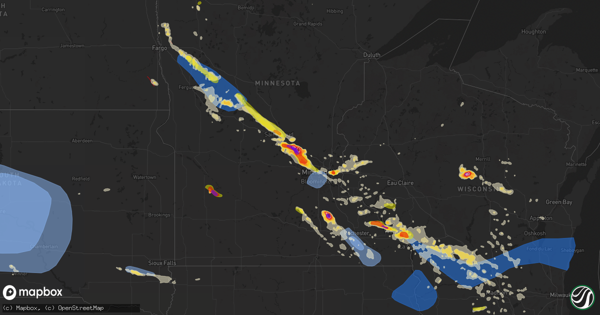
Hail Map on July 13, 2024
Get this storm
July 13 map
$229
one time, instant access
Download today. No call, no setup
Keep the $229
Bought the map and want the full workflow? Apply the entire $229 to a subscription within 7 days. None of it is wasted.
Every map, not just this one
This buys you this map. Subscription and you get every map we run, in the markets you choose from a few cities to whole states to nationwide. Plus real-time alerts the moment a storm fires.
Contact data
Name, contact info, occupancy, even credit band for addresses in the footprint. You go from where it hit to who to call.
Become the source they trust
Unlimited branding weather history reports on demand. You already have the documented answer ready for the property owner, and you are the one who showed up with it.
Property data and RoofTrace estimates
Pull up any address you have got, its value and the exact code rules for that jurisdiction, straight from One Click Code. Then RoofTrace estimates the squares, pitch, and roof value, priced the way you price.
States Impacted by Hail Map on July 13, 2024
Storm reports
Utah
| Date | Description |
|---|---|
| 07/13/20242:58 PM CDT | Center field observation. |
| 07/12/202410:30 PM CDT | Mesonet station utrvt sr-154 at mp 7 riverton. |
Wisconsin
| Date | Description |
|---|---|
| 07/13/20246:50 PM CDT | A local report indicates 1.00 inch wind near Trempealeau |
| 07/13/20246:45 PM CDT | Measured wind gust of 67 mph. Large branches down in nearby woods. |
| 07/13/20246:40 PM CDT | Large tree branches down. |
| 07/13/20246:34 PM CDT | Downed trees... Power outages. Public report via twitter. |
| 07/13/20246:20 PM CDT | Several trees down. |
| 07/13/20246:18 PM CDT | Delayed report. Trees down. Time estimated from radar. |
| 07/13/20246:16 PM CDT | Trees and power lines down in hillsboro. |
| 07/13/20245:53 PM CDT | Asos station klse la crosse regional airport. |
| 07/13/20245:50 PM CDT | Branches and power lines down. |
| 07/13/20245:48 PM CDT | Numerous trees down in the lake arrowhead and lake sherwood subdivisions. |
| 07/13/20245:48 PM CDT | Delayed report. Damage to a outbuilding and garage. |
| 07/13/20245:45 PM CDT | Delayed report. Trees down. Time estimated from radar. |
| 07/13/20245:38 PM CDT | Numerous trees and power lines down around town. |
| 07/13/20245:34 PM CDT | Corrects time from previous tstm wnd dmg report from onalaska. Downed trees... Power outages. Public report via twitter. |
| 07/13/20245:26 PM CDT | Report from mping: 1-inch tree limbs broken; shingles blown off. |
| 07/13/20245:15 PM CDT | A local report indicates 1.00 inch wind near Holmen |
| 07/13/20245:12 PM CDT | A local report indicates 1.50 inch wind near Trempealeau |
| 07/13/20245:06 PM CDT | Report from mping: quarter |
| 07/13/20245:05 PM CDT | Public report via facebook photo. |
| 07/13/20244:50 PM CDT | Delayed report. Trees down. Time estimated from radar. |
| 07/13/20244:39 PM CDT | Several trees snapped and uprooted. |
| 07/13/20244:35 PM CDT | 12 inch diameter tree uprooted. |
| 07/13/20244:26 PM CDT | Power lines and trees down in hixton area. |
| 07/13/20243:59 PM CDT | Trees and power lines down across central trempealeau county... Mainly independence and whitehall areas. |
| 07/13/20243:45 PM CDT | One large uprooted tree. Report relayed by wsaw wausau. |
| 07/13/20243:40 PM CDT | A local report indicates 1.00 inch wind near Gilmanton |
| 07/13/20243:40 PM CDT | Several trees down between gilmanton and mondovi. |
| 07/13/20243:18 PM CDT | Delayed report... Time estimated from radar. Tree down in pepin. |
| 07/13/20243:15 PM CDT | Hail size estimated based on picture. |
| 07/13/20243:15 PM CDT | A local report indicates 2.00 inch wind near 3 W Poniatowski |
| 07/13/20243:15 PM CDT | Hail size estimated based on picture sent in. |
| 07/13/20244:45 AM CDT | Trained spotter reports downed branches near lake delton. Time estimated from radar. |
| 07/13/20244:30 AM CDT | Delayed report of downed trees near the community of la valle. Time confirmed via radar data. |
| 07/12/20249:20 PM CDT | A local report indicates 67 MPH wind near 3 N Prairie Du Chien |
| 07/12/20249:11 PM CDT | A local report indicates 1.00 inch wind near 5 E Blanchardville |
| 07/12/20248:28 PM CDT | A portion of a soffit ripped off a home and a heavy grill moved. |
| 07/12/20248:05 PM CDT | Corrects previous tstm wnd dmg report from 2 wsw fond du lac. 68 mph wind gust at fond du lac county airport. |
| 07/12/20248:05 PM CDT | 68 mph wind gust at fond du lac county airport. |
Nebraska
| Date | Description |
|---|---|
| 07/13/20244:15 AM CDT | Measured wind gust from a public weather station. |
| 07/13/20243:14 AM CDT | A local report indicates 59 MPH wind near 5 SW Butte |
| 07/13/20242:38 AM CDT | Asos station kvtn valentine airport. |
Idaho
| Date | Description |
|---|---|
| 07/13/20246:00 PM CDT | Mesonet station los lost river rest area. |
Maine
| Date | Description |
|---|---|
| 07/13/20245:10 PM CDT | Corrects timing of previous tstm wnd dmg report from 2 n old orchard beach. Delayed report. Trees and wires down with trees blocking both lanes of ross road. Timing est |
| 07/13/20244:15 PM CDT | Tree reported down across stream rd. Time estimated from radar. |
| 07/13/20244:10 PM CDT | Delayed report. Trees and wires down with trees blocking both lanes of ross road. |
| 07/13/20243:55 PM CDT | Delayed report. 2 trees reported down on hinckley road. Time estimated from radar. |
| 07/13/20243:45 PM CDT | Tree down on wires and is on fire. |
| 07/13/20243:13 PM CDT | Trees and wires down on walker road. Time estimated based on radar. |
| 07/12/20248:37 PM CDT | Tree down on lakeview road and ambulance cannot get through. |
| 07/12/20248:15 PM CDT | Numerous trees and wires down in multiple areas near pushaw and lakeview roads. Report via penobscot rcc and social media. Time estimated based on radar. |
| 07/12/20248:06 PM CDT | Tree down blocking road. |
Kentucky
| Date | Description |
|---|---|
| 07/13/20246:26 PM CDT | Large branches and tree uproot occurred in goshen near highway 1793. |
Missouri
| Date | Description |
|---|---|
| 07/13/20248:17 AM CDT | Large tree branches down between stoutland and montreal. Large amount of small hail as well. |
| 07/13/20248:10 AM CDT | Several trees uprooted. Large tree branches down 3 miles south of montreal on highway 7. |
Oregon
| Date | Description |
|---|---|
| 07/13/20246:35 PM CDT | Mesonet station od111 10.9 n catnip mountain |
North Dakota
| Date | Description |
|---|---|
| 07/12/202410:33 PM CDT | Ndawn station located 3w of cedar lake. |
| 07/12/202410:07 PM CDT | Davis instrument. 0.56 hundredths of rain. |
| 07/12/20247:20 PM CDT | Tornado on the ground doing active damage 9 wsw colfax. Trees down. |
California
| Date | Description |
|---|---|
| 07/13/20246:32 PM CDT | Facebook report of quarter sized hail at 4:32 pm. |
| 07/13/20244:14 PM CDT | Chp reports 120 foot pine tree down on clemens ave. |
Illinois
| Date | Description |
|---|---|
| 07/13/20244:45 PM CDT | Tree snapped halfway up and several large tree limbs downed in the tall grass subdivision of naperville. Time estimated from radar. |
| 07/13/20244:45 PM CDT | Delayed report of a softwood tree blown down and most of a small hardwood tree peeled down from the trunk. Time estimated. |
| 07/13/20244:43 PM CDT | Multiple tree limbs were blown down near hoffman road and wolfs road up to 14 inches in diameter in far southeast aurora. Time estimated. |
| 07/13/20243:25 PM CDT | Report of a trailer house destroyed along with damage to a morton building. Pictures also relayed via facebook. Time estimated based on radar. |
| 07/13/20246:35 AM CDT | Trees downed onto power lines along pines road west of oregon. |
| 07/13/20241:11 AM CDT | Reasonably healthy 12 inch diameter tree downed just south of 1st street and bethany road. |
| 07/12/202410:39 PM CDT | Tree downed onto roadway at kishwaukee street and 3rd avenue. Time estimated from radar. |
Kansas
| Date | Description |
|---|---|
| 07/13/20247:40 AM CDT | 4 inch diameter branch down... Along with a few other smaller branches. |
South Dakota
| Date | Description |
|---|---|
| 07/13/20245:15 AM CDT | Small tree and numerous small branches down in beloit. |
| 07/13/20245:10 AM CDT | Numerous large tree limbs down throughout canton... With several power lines down. |
| 07/13/20245:07 AM CDT | An sddot site in davis recorded a 64 mph wind gust. |
| 07/13/20244:40 AM CDT | An sddot site in parker recorded a 64 mph wind gust. |
| 07/13/20243:56 AM CDT | A local report indicates 60 MPH wind near 1 NE Winner |
| 07/13/20243:45 AM CDT | A local report indicates 68 MPH wind near 1 NE Winner |
| 07/13/20243:36 AM CDT | A 62 mph wind gust was recorded at the huron regional airport. |
| 07/13/20243:35 AM CDT | A local report indicates 58 MPH wind near 2 W Hamill |
| 07/13/20243:33 AM CDT | The sddot site at the platte-winner bridge recorded a 68 mph wind gust. |
| 07/13/20243:28 AM CDT | The sddot site in dixon recorded a 72 mph wind gust. |
| 07/13/20243:25 AM CDT | A local report indicates 60 MPH wind near 2 W Hamill |
| 07/13/20243:16 AM CDT | A local report indicates 64 MPH wind near 1 NE Winner |
| 07/13/20243:10 AM CDT | A local report indicates 61 MPH wind near 2 W Hamill |
| 07/13/20243:09 AM CDT | A local report indicates 58 MPH wind near Wewela |
| 07/13/20242:57 AM CDT | The wolsey sddot site recorded a 70 mph wind gust. |
| 07/13/20242:56 AM CDT | A local report indicates 64 MPH wind near 1 NE Winner |
| 07/13/20242:50 AM CDT | A local report indicates 63 MPH wind near 2 W Hamill |
| 07/13/20242:48 AM CDT | The dixon mesonet recorded a 64 mph wind gust. |
| 07/13/20242:39 AM CDT | A local report indicates 62 MPH wind near Wewela |
| 07/13/20242:35 AM CDT | A local report indicates 64 MPH wind near 2 W Hamill |
| 07/13/20242:35 AM CDT | The chamberlain asos recorded a 60 mph wind gust. |
| 07/13/20242:35 AM CDT | Mesonet station ocms2 oacoma 2w |
| 07/13/20242:33 AM CDT | An sddot site in kimball recorded a 58 mph wind gust. |
| 07/13/20242:33 AM CDT | A local report indicates 64 MPH wind near 1 NE Winner |
| 07/13/20242:32 AM CDT | Mesonet station 201 gann valley |
| 07/13/20242:23 AM CDT | Mesonet station 312 ree heights |
| 07/13/20242:22 AM CDT | Mesonet station 289 lees corner |
| 07/13/20242:20 AM CDT | A local report indicates 67 MPH wind near 2 W Hamill |
| 07/13/20242:20 AM CDT | The gregory n mesonet recorded a 61 mph wind gust. |
| 07/13/20242:19 AM CDT | A local report indicates 60 MPH wind near 15 SSE Mission |
| 07/13/20242:17 AM CDT | Mesonet station 215 polo 17 w jct sd47/sd26 |
| 07/13/20242:16 AM CDT | Mesonet station 54 reliance |
| 07/13/20242:15 AM CDT | Mesonet station ocms2 oacoma 2w |
| 07/13/20242:15 AM CDT | A local report indicates 65 MPH wind near 2 W Hamill |
| 07/13/20242:14 AM CDT | A local report indicates 59 MPH wind near 15 SSE Mission |
| 07/13/20242:12 AM CDT | Mesonet station 212 agar |
| 07/13/20242:10 AM CDT | Mesonet station hihs2 highmore |
| 07/13/20242:10 AM CDT | A local report indicates 58 MPH wind near 2 W Hamill |
| 07/13/20242:06 AM CDT | Mesonet station 183 macs corner |
| 07/13/20242:05 AM CDT | Time estimated based on radar |
| 07/13/20242:05 AM CDT | A local report indicates 69 MPH wind near 7 ESE Rosebud |
| 07/13/20242:01 AM CDT | Mesonet station 54 reliance |
| 07/13/20242:01 AM CDT | Mesonet station 183 macs corner |
| 07/13/20241:59 AM CDT | Mesonet station rfps2 vivian 13 n. |
| 07/13/20241:58 AM CDT | Mesonet station 19 harrold |
| 07/13/20241:55 AM CDT | Mesonet station dvi01081 presho. |
| 07/13/20241:55 AM CDT | Mesonet station onms2 onida 13wsw |
| 07/13/20241:52 AM CDT | Mesonet station 285 14w lower brule |
| 07/13/20241:51 AM CDT | Mesonet station 157 forest city |
| 07/13/20241:50 AM CDT | Asos station kpir pierre muni ap. |
| 07/13/20241:47 AM CDT | A local report indicates 59 MPH wind near 9 ENE Belvidere |
| 07/13/20241:43 AM CDT | A local report indicates 65 MPH wind near 10 NNE White River |
| 07/13/20241:41 AM CDT | A local report indicates 58 MPH wind near 1 NE Midland |
| 07/13/20241:38 AM CDT | Mesonet station 13 vivian |
| 07/13/20241:38 AM CDT | A local report indicates 65 MPH wind near 10 NNE White River |
| 07/13/20241:37 AM CDT | A local report indicates 60 MPH wind near 9 ENE Belvidere |
| 07/13/20241:35 AM CDT | Six 20x20 foot doors blown off local construction company shop. Time estimated based on radar data. |
| 07/13/20241:35 AM CDT | Corrects the time from the previous tstm wnd dmg report from 1 nnw fort pierre. Damage to grain bins at local agricultural service. Time estimated based on radar data. |
| 07/13/20241:35 AM CDT | Several campers/travel trailers damaged or overturned at local business. Time estimated based on radar data. |
| 07/13/20241:33 AM CDT | A local report indicates 64 MPH wind near 10 NNE White River |
| 07/13/20241:31 AM CDT | Asos station kpir pierre muni ap. |
| 07/13/20241:30 AM CDT | A local report indicates 59 MPH wind near 4 WNW Cedar Butte |
| 07/13/20241:28 AM CDT | A local report indicates 61 MPH wind near 7 E Wanblee |
| 07/13/20241:27 AM CDT | Mesonet station 185 blunt |
| 07/13/20241:20 AM CDT | Mesonet station onms2 onida 13wsw |
| 07/13/20241:15 AM CDT | A local report indicates 71 MPH wind near 3 ENE Midland |
| 07/13/20241:08 AM CDT | Mesonet station 202 hayes |
| 07/13/20241:05 AM CDT | A local report indicates 67 MPH wind near 1 WSW South Eagle Butte |
| 07/13/20241:05 AM CDT | A local report indicates 59 MPH wind near 2 E Cottonwood |
| 07/13/202412:59 AM CDT | A local report indicates 59 MPH wind near 4 E Cactus Flat |
| 07/13/202412:55 AM CDT | Several large trees down and some structural damage around town. Time estimated from radar. |
| 07/13/202412:55 AM CDT | Mesonet station hams2 hayes 7sw |
| 07/13/202412:55 AM CDT | A local report indicates 59 MPH wind near 6 W Cottonwood |
| 07/13/202412:54 AM CDT | Mesonet station 202 hayes |
| 07/13/202412:54 AM CDT | A local report indicates 66 MPH wind near 10 NNW Ottumwa |
| 07/13/202412:52 AM CDT | Mesonet station lans2 bear creek. |
| 07/13/202412:50 AM CDT | Mesonet station hams2 hayes 7sw |
| 07/13/202412:50 AM CDT | A local report indicates 78 MPH wind near 1 WSW South Eagle Butte |
| 07/13/202412:50 AM CDT | A local report indicates 59 MPH wind near 2 E Cottonwood |
| 07/13/202412:50 AM CDT | A local report indicates 81 MPH wind near 3 E Philip |
| 07/13/202412:49 AM CDT | Mesonet station 168 foster bay |
| 07/13/202412:46 AM CDT | 3 inch tree limbs broken and power poles broken. |
| 07/13/202412:45 AM CDT | Mesonet station dvi03752 hayes. |
| 07/13/202412:44 AM CDT | A local report indicates 64 MPH wind near 3 E Philip |
| 07/13/202412:40 AM CDT | A local report indicates 76 MPH wind near 1 WSW South Eagle Butte |
| 07/13/202412:39 AM CDT | A local report indicates 65 MPH wind near 2 SW Bridger |
| 07/13/202412:39 AM CDT | A local report indicates 93 MPH wind near 10 NNW Ottumwa |
| 07/13/202412:35 AM CDT | A local report indicates 73 MPH wind near 1 WSW South Eagle Butte |
| 07/13/202412:34 AM CDT | A local report indicates 77 MPH wind near 10 NNW Ottumwa |
| 07/13/202412:29 AM CDT | A local report indicates 68 MPH wind near 2 SW Bridger |
| 07/13/202412:24 AM CDT | A local report indicates 58 MPH wind near 3 NW Wasta |
| 07/13/202412:20 AM CDT | A local report indicates 70 MPH wind near 11 W Milesville |
| 07/13/202412:20 AM CDT | Trees uprooted/damaged. Time estimated based on radar data. |
| 07/13/202412:20 AM CDT | Mesonet station lans2 bear creek. Time estimated based on radar data. |
| 07/13/202412:15 AM CDT | Roof partially blown off of barn at dupree rodeo arena. Tree branches and a few power poles down countywide. Time estimated from radar. |
| 07/13/202412:14 AM CDT | A local report indicates 85 MPH wind near 2 SW Bridger |
| 07/13/202412:10 AM CDT | A local report indicates 68 MPH wind near 11 W Milesville |
| 07/13/202412:09 AM CDT | A local report indicates 74 MPH wind near 2 SW Bridger |
| 07/13/202412:04 AM CDT | A local report indicates 58 MPH wind near 5 WNW New Underwood |
| 07/13/202412:00 AM CDT | Reports of downed trees and impassible roads in faith. Winds estimated at 80-90 mph. Time estimated based on radar. |
| 07/12/202411:51 PM CDT | A local report indicates 66 MPH wind near 3 W Union Center |
| 07/12/202411:47 PM CDT | A local report indicates 78 MPH wind near Usta |
| 07/12/202411:45 PM CDT | A local report indicates 60 MPH wind near 6 WSW Opal |
| 07/12/202411:45 PM CDT | A local report indicates 84 MPH wind near 6 WSW Fairpoint |
| 07/12/202411:41 PM CDT | A local report indicates 65 MPH wind near 3 W Union Center |
| 07/12/202411:40 PM CDT | 60-70 mph winds. 4 to 5 inch diameter branches broken off trees. |
| 07/12/202411:40 PM CDT | Damage to roof of trailer home. |
| 07/12/202411:40 PM CDT | A local report indicates 67 MPH wind near Union Center |
| 07/12/202411:35 PM CDT | A local report indicates 61 MPH wind near Union Center |
| 07/12/202411:30 PM CDT | A local report indicates 83 MPH wind near 9 SE Mud Butte |
| 07/12/202411:30 PM CDT | A local report indicates 58 MPH wind near 6 WSW Opal |
| 07/12/202411:25 PM CDT | Correction to time |
| 07/12/202411:25 PM CDT | Time estimated based on radar |
| 07/12/202411:20 PM CDT | A local report indicates 60 MPH wind near Bison |
| 07/12/202411:15 PM CDT | A local report indicates 58 MPH wind near 1 NNW Nisland |
| 07/12/202411:15 PM CDT | A local report indicates 88 MPH wind near 1 ENE Mud Butte |
| 07/12/202411:12 PM CDT | A local report indicates 76 MPH wind near 8 E Prairie City |
| 07/12/202411:09 PM CDT | A local report indicates 59 MPH wind near 7 WSW Hoover |
| 07/12/202411:04 PM CDT | A local report indicates 70 MPH wind near 13 NE Newell |
| 07/12/202410:56 PM CDT | A local report indicates 70 MPH wind near 13 SSW Reva |
| 07/12/202410:56 PM CDT | A local report indicates 66 MPH wind near 27 WNW Castle Rock |
| 07/12/202410:55 PM CDT | A local report indicates 102 MPH wind near 12 WSW Castle Rock |
| 07/12/202410:55 PM CDT | A local report indicates 74 MPH wind near 10 W Reva |
| 07/12/202410:54 PM CDT | A local report indicates 108 MPH wind near 7 WSW Hoover |
| 07/12/202410:50 PM CDT | A local report indicates 64 MPH wind near 10 W Reva |
| 07/12/202410:49 PM CDT | A local report indicates 91 MPH wind near 7 WSW Hoover |
| 07/12/202410:47 PM CDT | A local report indicates 74 MPH wind near 7 NNE Ralph |
| 07/12/202410:45 PM CDT | A local report indicates 61 MPH wind near 14 WNW Lodgepole |
| 07/12/202410:45 PM CDT | A local report indicates 69 MPH wind near 12 WSW Castle Rock |
| 07/12/202410:45 PM CDT | Many trees snapped. Barn roof partially torn off. Stockade damage. Time estimated from radar. |
| 07/12/202410:45 PM CDT | A local report indicates 90 MPH wind near 7 E Redig |
| 07/12/202410:45 PM CDT | Numerous branches 8-10 inches in diameter broken. Stockade blown down. Hay bales displaced. |
| 07/12/202410:44 PM CDT | A local report indicates 67 MPH wind near 7 WSW Hoover |
| 07/12/202410:42 PM CDT | A local report indicates 64 MPH wind near 7 NNE Ralph |
| 07/12/202410:40 PM CDT | Roofs blown off of storage shed and trailer. Time estimated from radar. |
| 07/12/202410:40 PM CDT | A local report indicates 87 MPH wind near 3 N Redig |
| 07/12/202410:25 PM CDT | Two buildings destroyed. Lots of tree and stockade damage. Time estimated from radar. |
| 07/12/202410:20 PM CDT | Photo shows a large hole in siding of a farm outbuilding. Widespread damage reported between harding and camp crook. Time estimated from radar. |
| 07/12/202410:15 PM CDT | A local report indicates 70 MPH wind near 1 ESE Ladner |
New Hampshire
| Date | Description |
|---|---|
| 07/13/20244:05 PM CDT | Delayed report. Time estimated from radar. Multiple trees snapped in effingham along rt. 25a. Large tree fell into a parked vehicle and crushed it. Tress branches fell |
Minnesota
| Date | Description |
|---|---|
| 07/13/20246:51 PM CDT | Asos station krst rochester international airport. |
| 07/13/20246:50 PM CDT | A local report indicates 1.50 inch wind near 5 NNW Nodine |
| 07/13/20246:45 PM CDT | Asos station krst rochester international airport. |
| 07/13/20246:45 PM CDT | A local report indicates 1.75 inch wind near 5 E Pickwick |
| 07/13/20246:37 PM CDT | Several large limbs down... Including on a house. |
| 07/13/20246:30 PM CDT | A local report indicates 1.00 inch wind near 3 E Winger |
| 07/13/20246:29 PM CDT | Downed power poles. |
| 07/13/20246:15 PM CDT | Delayed report... Time estimated from radar. 6 to 8 trees down in the southeast bay of waktins lake. |
| 07/13/20246:15 PM CDT | Delayed report... Time estimated from radar. Large tree across road. Several pine trees snapped. |
| 07/13/20245:52 PM CDT | A local report indicates 2.00 inch wind near Goodview |
| 07/13/20245:47 PM CDT | A local report indicates 2.00 inch wind near 1 SE Rollingstone |
| 07/13/20245:47 PM CDT | A local report indicates 2.00 inch wind near 1 W Minnesota City |
| 07/13/20245:35 PM CDT | Relayed via county official. |
| 07/13/20245:08 PM CDT | A local report indicates 1.75 inch wind near 6 N Nodine |
| 07/13/20245:05 PM CDT | Found at 510 pm with time it fell estimated based on radar. |
| 07/13/20245:05 PM CDT | A local report indicates 1.00 inch wind near Trempealeau |
| 07/13/20245:00 PM CDT | A local report indicates 1.00 inch wind near Pickwick |
| 07/13/20244:59 PM CDT | Reported by a trained spotter near the intersection of 270th st. E and 59th ave. |
| 07/13/20244:58 PM CDT | A local report indicates 1.25 inch wind near 2 SE Le Center |
| 07/13/20244:40 PM CDT | A local report indicates 1.00 inch wind near 1 NE Le Center |
| 07/13/20244:33 PM CDT | A local report indicates 1.75 inch wind near 2 SSE Nerstrand |
| 07/13/20243:10 PM CDT | Observation at station mn069. |
| 07/13/20248:00 AM CDT | A local report indicates 1.00 inch wind near Wood Lake |
| 07/13/20248:00 AM CDT | Caller noted a lot of corn damage associated with hail. |
| 07/13/20241:25 AM CDT | Report from mping: 3-inch tree limbs broken; power poles broken with times estimated based on radar. |
| 07/13/20241:20 AM CDT | Delayed report... Time estimated from radar. Several tree branches down and lawn furniture knocked over. Report via x. |
| 07/13/20241:18 AM CDT | Personal weather station measurement from state agency meteorologist. |
| 07/13/20241:15 AM CDT | Delayed report... Time estimated from radar. Large tree snapped near the st. Paul cathedral. Report via x. |
| 07/13/20241:12 AM CDT | A local report indicates 62 MPH wind near MSP Airport |
| 07/13/20241:10 AM CDT | Delayed report... Time estimated from radar. Large trees |
| 07/13/20241:10 AM CDT | Relayed via metro skywarn. |
| 07/13/20241:08 AM CDT | Measured from personal weather station. |
| 07/13/20241:05 AM CDT | Delayed report with photos of a few large trees and numerous branches down near wolfe park. Time estimated from radar. |
| 07/13/20241:05 AM CDT | Photo of uprooted 16-21 inch round tree at minneapolis college of art and design. |
| 07/13/20241:05 AM CDT | Delayed report... Time estimated from radar. Large trees between 12-24 inch diameter |
| 07/13/20241:00 AM CDT | Delayed report... Time estimated from radar. Large trees down near the intersection of laurel ave and rhode island ave. Report via x. |
| 07/13/202412:45 AM CDT | Delayed report... Time estimated from radar. Large tree |
| 07/13/202412:42 AM CDT | Delayed report: photo with a few large hail stones between 2.0 and 2.25 inches in diameter on a measuring tape. Time estimated via radar. |
| 07/13/202412:35 AM CDT | Delayed report: caller reported several branches down on property ranging from 4 to 8 inches in diameter. |
| 07/13/202412:30 AM CDT | Delayed report... Time estimated from radar. Trees down in st michael. |
| 07/13/202412:29 AM CDT | Phoned in report. |
| 07/13/202412:25 AM CDT | Delayed report... Time estimated from radar. Trees down in albertville. |
| 07/13/202412:25 AM CDT | Delayed report: several branches down ranging from 8 to 12 inches in diameter. |
| 07/13/202412:15 AM CDT | Hail started around 11:50pm... Progressively got bigger to golf ball size hail. |
| 07/13/202412:15 AM CDT | A local report indicates 1.75 inch wind near Big Lake |
| 07/13/202412:12 AM CDT | Delayed report... Time estimated from radar. Trees down in st augusta. |
| 07/13/202412:10 AM CDT | A local report indicates 2.00 inch wind near 2 ESE Monticello |
| 07/13/202412:10 AM CDT | Sent with a picture showing the hail by a measuring tape. |
| 07/13/202412:09 AM CDT | Relayed via metro skywarn. |
| 07/13/202412:06 AM CDT | Delayed report: via twitter. Video shows hail falling and follow up tweet measured the largest hail stones at 1 inch in diameter. Time estimated via radar. |
| 07/12/202411:59 PM CDT | Delayed report... Time estimated from radar. Trees down in annandale. |
| 07/12/202411:56 PM CDT | Report from mping: quarter |
| 07/12/202411:56 PM CDT | Report from mping: trees uprooted or snapped; roof blown off with time estimated based on radar. |
| 07/12/202411:55 PM CDT | Report from mping: quarter |
| 07/12/202411:50 PM CDT | Delayed report. A 1.5 foot diameter oak tree snapped 7.5 feet above base. Photos included with report. |
| 07/12/202411:42 PM CDT | A local report indicates 1.00 inch wind near 1 SE Clearwater |
| 07/12/202411:42 PM CDT | Delayed report... Time estimated from radar. Trees down in rockville. |
| 07/12/202411:38 PM CDT | Report from mping: half dollar |
| 07/12/202411:30 PM CDT | A local report indicates 1.75 inch wind near 1 SE Clearwater |
| 07/12/202411:11 PM CDT | Delayed report... Time estimated from radar. Trees down near buckhead lake. |
| 07/12/202410:56 PM CDT | Delayed report... Time estimated from radar. Trees down on 243rd ave near long prairie. |
| 07/12/202410:39 PM CDT | Via social media. |
| 07/12/202410:15 PM CDT | Large trees blown down... Relayed by broadcast media. |
| 07/12/202410:14 PM CDT | Report from mping: quarter |
| 07/12/202410:14 PM CDT | Report from mping: trees uprooted or snapped; roof blown off. |
| 07/12/20249:55 PM CDT | A local report indicates 1.00 inch wind near Fergus Falls |
| 07/12/20249:53 PM CDT | A local report indicates 1.00 inch wind near 1 ESE Ottertail |
| 07/12/20249:25 PM CDT | Multiple trees down with power outages as well. |
| 07/12/20249:25 PM CDT | Corrects previous hail report from 2 wnw cormorant. |
| 07/12/20249:25 PM CDT | A local report indicates 1.00 inch wind near 2 WNW Cormorant |
| 07/12/20249:10 PM CDT | Tree damage in town... Time estimated from radar. |
| 07/12/20248:00 PM CDT | Corrects previous tstm wnd dmg report from felton. Roof taken off of a shed near felton. Time estimated from radar. |
| 07/12/20247:45 PM CDT | Roof taken off of a shed near felton. Time estimated from radar. |
| 07/12/20247:25 PM CDT | Downed trees and power poles. |
| 07/12/20247:00 PM CDT | A local report indicates 74 MPH wind near 5 WSW Cummingsville |
Nevada
| Date | Description |
|---|---|
| 07/13/20246:56 PM CDT | A local report indicates 58 MPH wind near Harry Reid Airport |
| 07/13/20246:47 PM CDT | Currant creek raws |
| 07/13/20246:32 PM CDT | Timber mountain raws |
| 07/13/20243:45 PM CDT | A local report indicates 63 MPH wind near 16 N Mercury |
| 07/12/20248:37 PM CDT | Measured at desert rock airport. |
| 07/12/20248:37 PM CDT | Measured at desert roc |
Indiana
| Date | Description |
|---|---|
| 07/13/20244:58 PM CDT | Multiple broken tree branches... Including a large snapped branch of a healthy maple tree about a foot in diameter. |
| 07/13/20244:51 PM CDT | Snapped power pole at intersection of new middletown road at st peters church road near new middletown. |
Montana
| Date | Description |
|---|---|
| 07/13/20246:50 PM CDT | Mesonet station dw0807 circle. |
| 07/13/20246:45 PM CDT | Public report... Via facebook. |
| 07/13/20246:45 PM CDT | Reported via facebook. |
| 07/13/20246:45 PM CDT | Mesonet station mtluf 4.4 w sand springs |
| 07/13/20246:41 PM CDT | Mesonet station mcdm8 manning corral dogtown. Recorded sometime in the hour between 4:41 and 5:41 pm. |
| 07/13/20246:30 PM CDT | Relayed via fb. Also recorded 8 tenths of rain in a 20 minute period with strong winds |
| 07/13/20246:30 PM CDT | Observed at the sand springs nw hydromet site from the montana mesonets. |
| 07/13/20246:11 PM CDT | Public reported... Via facebook... Golf ball size hail. |
| 07/13/20245:52 PM CDT | Photos showing pontoon boat blown onto a trailer... Rv campers tipped over... And verbal reports of a fence damaged. |
| 07/13/20245:52 PM CDT | 4-inch diameter tree limbs downed. Building frame under construction knocked down. |
| 07/13/20245:40 PM CDT | Quarter to golf ball sized hail was reported by a trained spotter. Hail was reported as completely covering the ground. |
| 07/13/20245:35 PM CDT | Report from social media showing golf ball to egg sized hail that lasted from 423 pm to 435 pm. Public reported 0.2 inches of rain with the storm. |
| 07/13/20245:30 PM CDT | Reported via facebook. |
| 07/13/20245:30 PM CDT | Report of golf ball to baseball size hail that lasted from about 420 pm to 430 pm. Hail completely covered the ground. |
| 07/13/20245:25 PM CDT | Reported via social media with images. Time estimated by radar. |
| 07/13/20245:22 PM CDT | Asos station khvr havre airport. |
| 07/13/20245:18 PM CDT | Corrects previous tstm wnd gst report from 4 w havre. Asos station khvr havre airport. Corrected time. |
| 07/13/20245:15 PM CDT | Public reported golf ball size hail and 0.8 inch rainfall. |
| 07/13/20245:00 PM CDT | Lots of baseball size hail with a few softball size hail mixed in. Lots of wind. |
| 07/13/20244:50 PM CDT | Reported via facebook. Egg to tennis ball sized hail caused damage to windows. Time approximated based on radar. |
| 07/13/20244:38 PM CDT | Reported via facebook with image. Location estimated based upon radar. |
| 07/13/20244:30 PM CDT | Corrects previous hail report from 11 n hays. Lots of baseball size hail with a few softball size hail mixed in. Lots of wind. Time approximated from radar and correcte |
| 07/13/20244:20 PM CDT | Mixed sized hail with the largest being quarters fell for approximately 10 minutes. |
| 07/13/20244:15 PM CDT | Report on social media. Location estimated based on the report time given by the public and radar data. |
| 07/13/20243:40 PM CDT | Report from mping: quarter |
| 07/13/20243:14 PM CDT | Report from mping: quarter |
| 07/13/20242:55 PM CDT | Spotter measured 0.11 inches of rain with the storm. |
| 07/12/202410:00 PM CDT | Numerous power poles snapped in two. |
| 07/12/202410:00 PM CDT | Spotter had a broken window in his home. Not sure if it was from wind or hail. |
| 07/12/20249:58 PM CDT | A local report indicates 70 MPH wind near 4 N Belltower |
| 07/12/20249:58 PM CDT | 60 to 70 mph winds. |
| 07/12/20249:55 PM CDT | A local report indicates 63 MPH wind near 15 SE Ekalaka |
| 07/12/20249:51 PM CDT | A local report indicates 60 MPH wind near 1 E Ridgeway |
| 07/12/20249:40 PM CDT | Mesonet station ktfm8 knowlton. |
| 07/12/20249:25 PM CDT | Power poles down. Large tree limbs down. |
| 07/12/20249:25 PM CDT | Power poles down. |
| 07/12/20249:22 PM CDT | Asos station kbhk baker. |
| 07/12/20249:15 PM CDT | Mesonet station mteka baker mt-7 mp 14.2. |
| 07/12/20249:15 PM CDT | Mesonet station mtm39 4.7 e plevna |
| 07/12/20248:39 PM CDT | South sawmill creek raws site... Between 4:08 and 5:08 pm. |
| 07/12/20248:30 PM CDT | *** 3 inj *** several injuries due to trees falling on people and vehicles. At least one person hospitalized. No fatalities. |
| 07/12/20248:30 PM CDT | A local report indicates 77 MPH wind near 8 SE Tusler |
| 07/12/20248:28 PM CDT | Trees uprooted or snapped; roof blown off. |
| 07/12/20248:22 PM CDT | 3-inch tree limbs broken; power poles broken. |
| 07/12/20248:21 PM CDT | 1-inch tree limbs broken; shingles blown off. |
| 07/12/20248:16 PM CDT | A local report indicates 70 MPH wind near 4 NE Miles City |
| 07/12/20248:15 PM CDT | Fort keogh se mesonet. |
| 07/12/20248:10 PM CDT | Measured by storm spotter. |
| 07/12/20248:08 PM CDT | Tree and power line damage. Power out in miles city. |
| 07/12/20247:15 PM CDT | Reported via facebook with image. |
| 07/12/20247:00 PM CDT | Reported via facebook with images. Also windows broken in mobile home due to hail. |
Iowa
| Date | Description |
|---|---|
| 07/13/20245:48 AM CDT | Large trees down across the highway west of hull. |
| 07/13/20245:25 AM CDT | A few large branches down. |
Cities Impacted by Hail Map on July 13, 2024
- Clarkfield, MN
- Granite Falls, MN
- Becker, MN
- Blackwater, MO
- Franklin, MO
- Hanley Falls, MN
- Brumley, MO
- Lancaster, MN
- Balfour, ND
- Gilliam, MO
- Cottonwood, MN
- York, ND
- Richland, MO
- Iberia, MO
- Ulman, MO
- Karlsruhe, ND
- Rugby, ND
- Drake, ND
- Natoma, KS
- Montreal, MO
- Stoutland, MO
- Fayette, MO
- Wood Lake, MN
- New Franklin, MO
- Dixon, MO
- Glasgow, MO
- Echo, MN
- Saint Paul Park, MN
- South Saint Paul, MN
- Newport, MN
- Inver Grove Heights, MN
- Cottage Grove, MN
- Afton, MN
- Hastings, MN
- Saint Paul, MN
- Rosemount, MN
- Hermann, MO
- Morrison, MO
- Ponemah, MN
- Slater, MO
- Welch, MN
- Prescott, WI
- Barron, WI
- New Auburn, WI
- Blackduck, MN
- Grovespring, MO
- Hartville, MO
- Phillips, WI
- Park Falls, WI
- Bovey, MN
- Tower, MN
- Independence, LA
- Loranger, LA
- Tickfaw, LA
- Mount Olive, MS
- Stratford, WI
- Colby, WI
- Edgar, WI
- Lena, IL
- Ladysmith, WI
- Athens, WI
- Murphysboro, IL
- Lewisport, KY
- Philpot, KY
- Chinook, MT
- Collins, MS
- Clewiston, FL
- Seminary, MS
- Hager City, WI
- Red Wing, MN
- Antigo, WI
- Mondovi, WI
- Marathon, WI
- Mosinee, WI
- Nelson, WI
- Durand, WI
- Alma, WI
- Bay City, WI
- Saucier, MS
- Abbotsford, WI
- Dorchester, WI
- Cortland, OH
- Harlem, MT
- Wausau, WI
- Barstow, CA
- Hays, MT
- Fountain City, WI
- Cochrane, WI
- Labelle, FL
- Arcadia, WI
- Havre, MT
- Birnamwood, WI
- Rothschild, WI
- Plainview, MN
- Hatley, WI
- Faribault, MN
- Kenyon, MN
- Nerstrand, MN
- Le Center, MN
- Le Sueur, MN
- Kilkenny, MN
- Altura, MN
- Kellogg, MN
- Dodson, MT
- Bowler, WI
- Rosholt, WI
- Wittenberg, WI
- Winona, MN
- Trempealeau, WI
- Galesville, WI
- Holmen, WI
- Eland, WI
- New Middletown, IN
- Elizabeth, IN
- Corydon, IN
- Dodge, WI
- Dakota, MN
- Coxs Creek, KY
- Mojave, CA
- Onalaska, WI
- Minnesota City, MN
- Rollingstone, MN
- Malta, MT
- Zortman, MT
- Iola, WI
- Tigerton, WI
- Sublette, IL
- Midway, TX
- La Crescent, MN
- West Salem, WI
- West Brooklyn, IL
- Cantil, CA
- La Crosse, WI
- Brusett, MT
- Plum City, WI
- Winnett, MT
- Rockland, WI
- Bangor, WI
- Crockett, TX
- Centerville, TX
- Foxworth, MS
- Maiden Rock, WI
- Pepin, WI
- Stockholm, WI
- Black Creek, WI
- Sparta, WI
- Bear Creek, WI
- Shiocton, WI
- Humble, TX
- Stoddard, WI
- Chaseburg, WI
- Coon Valley, WI
- Norwalk, WI
- Westby, WI
- Cashton, WI
- Ontario, WI
- La Farge, WI
- Viroqua, WI
- Viola, WI
- Kendall, WI
- Hillsboro, WI
- Kingwood, TX
- Jordan, MT
- Sand Springs, MT
- Lloyd, MT
- Stevens Point, WI
- Prospect, KY
- Plover, WI
- Bancroft, WI
- Almond, WI
- Dodge Center, MN
- Byron, MN
- Mantorville, MN
- Kasson, MN
- Rochester, MN
- Grand Meadow, MN
- Stewartville, MN
- Racine, MN
- Hayfield, MN
- Chatfield, MN
- Spring Valley, MN
- Cohagen, MT
- Circle, MT
- Hancock, WI
- Coloma, WI
- Lake City, MN
- Wabasha, MN
- Amherst, WI
- Forsyth, MT
- Northfield, MN
- Waupaca, WI
- Plainfield, WI
- Wild Rose, WI
- Westfield, WI
- Wautoma, WI
- Dennison, MN
- Alpine, TX
- Wykoff, MN
- Le Roy, MN
- Preston, MN
- Fountain, MN
- Lanesboro, MN
- Harmony, MN
- Ostrander, MN
- Lone Rock, WI
- Plain, WI
- Readstown, WI
- Richland Center, WI
- Hillpoint, WI
- Spring Green, WI
- Cazenovia, WI
- Arlington, WI
- Poynette, WI
- Wonewoc, WI
- Prairie Du Sac, WI
- Merrimac, WI
- Baraboo, WI
- Fall River, WI
- La Valle, WI
- Loganville, WI
- Dane, WI
- North Freedom, WI
- Lodi, WI
- Arena, WI
- Rock Springs, WI
- Lime Ridge, WI
- Sauk City, WI
- Reedsburg, WI
- Portage, WI
- Columbus, WI
- Rio, WI
- Mazomanie, WI
- Rosebud, MT
- Angela, MT
- Kinsey, MT
- Neshkoro, WI
- Montello, WI
- Montgomery, MN
- Neenah, WI
- Appleton, WI
- Fort Davis, TX
- Weyauwega, WI
- Elgin, MN
- Princeton, WI
- Fort Peck, MT
- Berlin, WI
- Dalton, WI
- Pine River, WI
- Kimberly, WI
- Mooreton, ND
- Kingston, WI
- Randolph, WI
- Friesland, WI
- Cambria, WI
- Markesan, WI
- Green Lake, WI
- Hampton, MN
- Randolph, MN
- Jacumba, CA
- Lonsdale, MN
- Monticello, MS
- Sontag, MS
- Wesson, MS
- Pinola, MS
- Braxton, MS
- Squaw Lake, MN
- Max, MN
- Volborg, MT
- Miles City, MT
- Ismay, MT
- Terry, MT
- Fox Lake, WI
- Cannon Falls, MN
- Farmington, MN
- Avoca, WI
- Mendenhall, MS
- Blue Mounds, WI
- Black Earth, WI
- Cross Plains, WI
- Glyndon, MN
- Chilton, WI
- Pardeeville, WI
- Van Dyne, WI
- Rosendale, WI
- Oshkosh, WI
- Brandon, WI
- Ripon, WI
- Wisconsin Dells, WI
- Fairwater, WI
- Eldorado, WI
- Pickett, WI
- Marquette, WI
- Endeavor, WI
- Wyocena, WI
- Waupun, WI
- Fond Du Lac, WI
- Brownsville, WI
- Beaver Dam, WI
- Mayville, WI
- Oakfield, WI
- Malone, WI
- Campbellsport, WI
- Lomira, WI
- Burnett, WI
- Eden, WI
- Mount Calvary, WI
- Mount Horeb, WI
- Deforest, WI
- Madison, WI
- Verona, WI
- Middleton, WI
- Barneveld, WI
- Sun Prairie, WI
- Mcfarland, WI
- Waunakee, WI
- Cottage Grove, WI
- Lime Springs, IA
- Cresco, IA
- Canton, MN
- Port Washington, WI
- Fredonia, WI
- Belgium, WI
- Adell, WI
- Cascade, WI
- Waldo, WI
- Saukville, WI
- Kewaskum, WI
- Allenton, WI
- West Bend, WI
- Saint Cloud, WI
- Random Lake, WI
- Glenbeulah, WI
- Plymouth, WI
- New Holstein, WI
- Elkhart Lake, WI
- Sheboygan Falls, WI
- Oostburg, WI
- Cedar Grove, WI
- Kiel, WI
- Sheboygan, WI
- Kohler, WI
- Cleveland, WI
- Newton, WI
- Argyle, WI
- Blanchardville, WI
- Stoughton, WI
- Hollandale, WI
- Bristolville, OH
- Oregon, WI
- Kendall, KS
- New Glarus, WI
- Monticello, WI
- Belleville, WI
- Goodhue, MN
- Waterville, MN
- Morristown, MN
- Julian, CA
- Brooklyn, WI
- Medford, MN
- West Concord, MN
- Ferryville, WI
- Luana, IA
- Clermont, IA
- Postville, IA
- Monona, IA
- De Soto, WI
- Saint Olaf, IA
- Waterville, IA
- Waukon, IA
- Farmersburg, IA
- Harpers Ferry, IA
- Elgin, IA
- Eastman, WI
- Castalia, IA
- Lansing, IA
- Bagley, WI
- Garnavillo, IA
- Steuben, WI
- Prairie Du Chien, WI
- Wauzeka, WI
- Guttenberg, IA
- Elkader, IA
- McGregor, IA
- Gays Mills, WI
- Marquette, IA
- Mount Hope, WI
- Boscobel, WI
- Patch Grove, WI
- Bloomington, WI
- Glen Haven, WI
- Woodman, WI
- Pelican Rapids, MN
- Lake Park, MN
- Hawley, MN
- Ottertail, MN
- Dent, MN
- Battle Lake, MN
- Vergas, MN
- Richville, MN
- Erhard, MN
- Biddle, MT
- Hammond, MT
- Ekalaka, MT
- Powderville, MT
- Boyes, MT
- Grand Marsh, WI
- Oxford, WI
- Owatonna, MN
- Baker, MT
- Willard, MT
- Plevna, MT
- Northome, MN
- Barnesville, MN
- Rothsay, MN
- Detroit Lakes, MN
- Perham, MN
- Ashby, MN
- Underwood, MN
- Fergus Falls, MN
- Clitherall, MN
- Evansville, MN
- Henning, MN
- Capitol, MT
- Buffalo, SD
- Camp Crook, SD
- Alzada, MT
- Bowman, ND
- Rhame, ND
- Marmarth, ND
- Waseca, MN
- Juda, WI
- Monroe, WI
- Nunnelly, TN
- Claremont, MN
- Mazeppa, MN
- Zumbro Falls, MN
- Spring Lake, MN
- Yosemite National Park, CA
- Belle Fourche, SD
- Ludlow, SD
- Scranton, ND
- Prairie City, SD
- Ralph, SD
- Reva, SD
- Hettinger, ND
- Lodgepole, SD
- Reeder, ND
- Deer Creek, MN
- Parkers Prairie, MN
- Bertha, MN
- Miltona, MN
- Brandon, MN
- New York Mills, MN
- Garfield, MN
- Clarissa, MN
- Eagle Bend, MN
- Vining, MN
- Hewitt, MN
- Browerville, MN
- Lancaster, WI
- Cassville, WI
- Fennimore, WI
- Blooming Prairie, MN
- Newell, SD
- Saint Cloud, MN
- Dexter, MN
- Briggsville, WI
- Waltham, MN
- Sargeant, MN
- Fosston, MN
- Bejou, MN
- Borup, MN
- Pueblo, CO
- Colfax, ND
- Perley, MN
- Hendrum, MN
- Ada, MN
- Barney, ND
- Wahpeton, ND
- Georgetown, MN
- Felton, MN
- Ulen, MN
- Ogema, MN
- Callaway, MN
- Mahnomen, MN
- Richmond, MN
- Cold Spring, MN
- Rockville, MN
- Union Center, SD
- Mud Butte, SD
- Faith, SD
- Nisland, SD
- Vale, SD
- Sturgis, SD
- Whitewood, SD
- Meadow, SD
- Lemmon, SD
- Bison, SD
- New Underwood, SD
- Enning, SD
- Long Prairie, MN
- Burtrum, MN
- Grey Eagle, MN
- Freeport, MN
- Albany, MN
- Holdingford, MN
- Avon, MN
- Swanville, MN
- Upsala, MN
- Sartell, MN
- Bowlus, MN
- Saint Joseph, MN
- Sauk Rapids, MN
- Little Falls, MN
- Saint Stephen, MN
- Rice, MN
- Clearwater, MN
- Clear Lake, MN
- Monticello, MN
- Big Lake, MN
- Audubon, MN
- Cherry Valley, IL
- Rockford, IL
- Genoa, IL
- Garden Prairie, IL
- Belvidere, IL
- Winnebago, IL
- Alexandria, MN
- Osakis, MN
- Carlos, MN
- Nelson, MN
- Lake Elmo, MN
- Durand, IL
- Pecatonica, IL
- Leaf River, IL
- Dalton, MN
- Maple Lake, MN
- Buffalo, MN
- Annandale, MN
- Elk River, MN
- Hanover, MN
- Rogers, MN
- Albertville, MN
- Saint Michael, MN
- Brownsdale, MN
- Byron, IL
- Elkton, MN
- Austin, MN
- Greenfield, IN
- Morristown, IN
- Fountaintown, IN
- Maple Grove, MN
- Hamel, MN
- Loretto, MN
- Osseo, MN
- Anoka, MN
- Dayton, MN
- Dupree, SD
- Howes, SD
- Midland, SD
- Cherry Creek, SD
- Milesville, SD
- White Owl, SD
- Wasta, SD
- Hayes, SD
- Wall, SD
- Eagle Butte, SD
- Keldron, SD
- Lantry, SD
- Timber Lake, SD
- Isabel, SD
- McIntosh, SD
- Philip, SD
- Quinn, SD
- Elmwood, WI
- Waite Park, MN
- Menomonie, WI
- Ellsworth, WI
- Davis Junction, IL
- Rockford, MN
- Stillman Valley, IL
- Sauk Centre, MN
- Oregon, IL
- Chana, IL
- Kensington, MN
- Minneapolis, MN
- Champlin, MN
- Owanka, SD
- Waverly, MN
- Hudson, WI
- Roberts, WI
- Spring Valley, WI
- Beldenville, WI
- New Richmond, WI
- Lowry, MN
- Farwell, MN
- Star Prairie, WI
- Deer Park, WI
- Steger, IL
- Somerset, WI
- Houlton, WI
- Melrose, WI
- Glenwood City, WI
- River Falls, WI
- Arkansaw, WI
- Eau Galle, WI
- South Haven, MN
- Brooten, MN
- Forest Lake, MN
- Kimball, MN
- Osceola, WI
- Marine On Saint Croix, MN
- Hammond, WI
- Baldwin, WI
- Downing, WI
- Circle Pines, MN
- Monroe Center, IL
- Lindenwood, IL
- Bayport, MN
- Stillwater, MN
- Fort Pierre, SD
- Kadoka, SD
- Ridgeview, SD
- Wilson, WI
- Mindoro, WI
- Amery, WI
- Malta, IL
- Beecher, IL
- Crete, IL
- Woodville, WI
- Pierre, SD
- Wanblee, SD
- Murdo, SD
- Onida, SD
- Draper, SD
- Belvidere, SD
- Gettysburg, SD
- Long Valley, SD
- Agar, SD
- Okaton, SD
- Hugo, MN
- Eden Prairie, MN
- Hopkins, MN
- Shakopee, MN
- Chanhassen, MN
- Minnetonka, MN
- Prior Lake, MN
- Burnsville, MN
- Lakeville, MN
- Mendota, MN
- Savage, MN
- Chaska, MN
- Ettrick, WI
- Dekalb, IL
- White River, SD
- Interior, SD
- Blunt, SD
- Vivian, SD
- Presho, SD
- Norris, SD
- Harrold, SD
- Lee, IL
- Shabbona, IL
- Hinckley, IL
- Naperville, IL
- Plainfield, IL
- Aurora, IL
- Independence, WI
- Lower Brule, SD
- Witten, SD
- Winner, SD
- Reliance, SD
- Ideal, SD
- Gregory, SD
- Kennebec, SD
- Wood, SD
- Hamill, SD
- Fort Thompson, SD
- Highmore, SD
- Holabird, SD
- Seneca, SD
- Lebanon, SD
- Burke, SD
- Dallas, SD
- Chamberlain, SD
- Stephan, SD
- Oacoma, SD
- Gann Valley, SD
- Pukwana, SD
- Ree Heights, SD
- Platte, SD
- Miller, SD
- Orient, SD
- Blair, WI
- Frontenac, MN
- Millville, MN
- Winger, MN
- Kimball, SD
- Wessington, SD
- Wessington Springs, SD
- Saint Lawrence, SD
- White Lake, SD
- Kelliher, MN
- Dover, MN
- Houston, MN
- Saint Charles, MN
- Hokah, MN
- Elroy, WI
- Wilton, WI
- Tulare, SD
- Atkinson, NE
- Stuart, NE
- Mauston, WI
- Genoa, WI
- Lyndon Station, WI
- Emery, SD
- Doland, SD
- Carpenter, SD
- New Lisbon, WI
- Camp Douglas, WI
- Verdigre, NE
- Soldiers Grove, WI
- Bridgewater, SD
- Marion, SD
- Freeman, SD
- Blue River, WI
- Parker, SD
- Chancellor, SD
- Lennox, SD
- Canton, SD
- Beresford, SD
- Worthing, SD
- Platteville, WI
- Inwood, IA
- Fairview, SD
- Rock Valley, IA
- Marshall, WI
- Cuba City, WI
- Belmont, WI
- Shullsburg, WI
- Albany, WI
- Mission, SD
- Brodhead, WI
- Deerfield, WI
- Mound, MN
- Maple Plain, MN
- Browntown, WI
- Montrose, MN
- Evansville, WI
- Gratiot, WI
- Darlington, WI
- Warren, IL
- South Wayne, WI
- Long Lake, MN
- Edgerton, WI
- Janesville, WI
- Waterloo, WI
- George, IA
- Jefferson, WI
- Johnson Creek, WI
- Fort Atkinson, WI
- Lake Mills, WI
- Orangeville, IL
- Winslow, IL
- Watertown, WI
- Freeport, IL
- Shannon, IL
- Lanark, IL
- Whitewater, WI
- Ashton, IA
- German Valley, IL
- Wyanet, IL
- Pearl City, IL
- Baileyville, IL
- Mount Morris, IL
- Forreston, IL
- Amboy, IL
- Ashton, IL
- Franklin Grove, IL