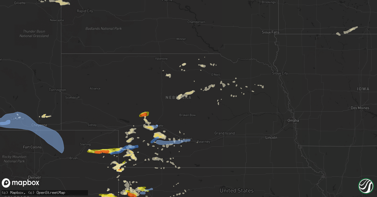
Hail Map in Nebraska on July 13, 2020
Get this storm
July 13 map
$229
one time, instant access
Download today. No call, no setup
Keep the $229
Bought the map and want the full workflow? Apply the entire $229 to a subscription within 7 days. None of it is wasted.
Every map, not just this one
This buys you this map. Subscription and you get every map we run, in the markets you choose from a few cities to whole states to nationwide. Plus real-time alerts the moment a storm fires.
Contact data
Name, contact info, occupancy, even credit band for addresses in the footprint. You go from where it hit to who to call.
Become the source they trust
Unlimited branding weather history reports on demand. You already have the documented answer ready for the property owner, and you are the one who showed up with it.
Property data and RoofTrace estimates
Pull up any address you have got, its value and the exact code rules for that jurisdiction, straight from One Click Code. Then RoofTrace estimates the squares, pitch, and roof value, priced the way you price.
Storm reports in Nebraska
Nebraska
| Date | Description |
|---|---|
| 07/13/20206:45 PM CDT | A local report indicates 1.00 inch wind near 12 ESE BUCKTAIL LAKE |
| 07/13/20206:57 AM CDT | At 1157 PM CDT, a severe thunderstorm was located near Woodruff, or 22 miles north of Phillipsburg, moving east at 55 mph. HAZARD...60 mph wind gusts. SOURCE...Radar indicated. IMPACT...Expect damage to roofs, siding, and trees. Locations impacted include... Alma, Oxford, Orleans, Stamford, Republican City, Long Island, Huntley, Ragan, Harlan County Dam and Woodruff. |
| 07/13/20206:31 AM CDT | At 1131 PM CDT, severe thunderstorms were located along a line extending from Holbrook to Hendley to 9 miles south of Wilsonville, moving east at 45 mph. HAZARD...60 mph wind gusts. SOURCE...Radar indicated. IMPACT...Expect damage to roofs, siding, and trees. Locations impacted include... Alma, Oxford, Beaver City, Orleans, Stamford, Republican City, Long Island, Prairie View, Edison, Huntley, Ragan, Hollinger, Woodruff and Harlan County Dam. |
| 07/13/20206:07 AM CDT | At 1107 PM CDT, severe thunderstorms were located along a line extending from near Wilsonville to 7 miles west of Norcatur, moving east at 40 mph. HAZARD...70 mph wind gusts and quarter size hail. SOURCE...Radar indicated. IMPACT...Hail damage to vehicles is expected. Expect considerable tree damage. Wind damage is also likely to mobile homes, roofs, and outbuildings. Locations impacted include... Norton, Oberlin, Almena, Lenora, Norcatur, Jennings and Lebanon. |
| 07/13/20205:14 AM CDT | At 1011 PM CDT, severe thunderstorms were located along a line extending from 4 miles northwest of McCook to 3 miles southwest of Herndon to 12 miles southeast of McDonald, moving east at 55 mph. HAZARD...60 mph wind gusts and quarter size hail. SOURCE...Trained weather spotters. At 948 pm CDT, a 62 mph wind gust was reported in Trenton, Nebraska. A 65 mph wind gusts was also reported in Ludell, Kansas at 1004 pm CDT. IMPACT...Hail damage to vehicles is expected. Expect wind damage to roofs, siding, and trees. Locations impacted include... McCook, Oberlin, Indianola, Bartley, Norcatur, Danbury and Jennings. |
| 07/13/20204:56 AM CDT | At 955 PM CDT, severe thunderstorms were located along a line extending from near Oconto to near Lexington to near Elwood to 11 miles north of Arapahoe, moving east at 50 mph. HAZARD...60 mph wind gusts and penny size hail. SOURCE...Radar indicated. IMPACT...Expect damage to roofs, siding, and trees. Locations impacted include... Kearney, Lexington, Holdrege, Cozad, Elm Creek, Bertrand, Axtell, Elwood, Overton, Odessa, Loomis, Amherst, Sumner, Funk, Riverdale, Miller, Eddyville, Smithfield and Johnson Lake.This includes Interstate 80 between mile markers 223 and 273. |
| 07/13/20204:45 AM CDT | At 945 PM CDT, severe thunderstorms were located along a line extending from near Eustis to 9 miles southwest of Stockville, moving east at 40 mph. HAZARD...60 mph wind gusts and nickel size hail. SOURCE...Radar indicated. IMPACT...Expect damage to roofs, siding, and trees. Locations impacted include... Eustis, Moorefield, Stockville, Medicine Creek Reservoir State Recreation Area, Orafino, Freedom and Dancing Leaf Earth Lodge. |
| 07/13/20204:34 AM CDT | At 933 PM CDT, severe thunderstorms were located along a line extending from 9 miles southeast of Wauneta to 10 miles north of McDonald to 8 miles southeast of St. Francis, moving east at 45 mph. HAZARD...60 mph wind gusts and quarter size hail. SOURCE...Law enforcement. At 921 pm CDT, a 58 mph wind gust was reported in Benkelman. IMPACT...Hail damage to vehicles is expected. Expect wind damage to roofs, siding, and trees. Locations impacted include... Atwood, Trenton, Culbertson, Palisade, Stratton, McDonald and Herndon. |
| 07/13/20204:13 AM CDT | At 912 PM CDT, severe thunderstorms were located along a line extending from 11 miles northeast of Maxwell to 7 miles northeast of Moorefield to 10 miles north of McCook, moving east at 35 mph. These are very dangerous storms. HAZARD...80 mph wind gusts and quarter size hail. SOURCE...Radar indicated. IMPACT...Flying debris will be dangerous to those caught without shelter. Mobile homes will be heavily damaged. Expect considerable damage to roofs, windows, and vehicles. Extensive tree damage and power outages are likely. Locations impacted include... Lexington, Cozad, Gothenburg, Elwood, Smithfield, Willow Island, Johnson Lake and Farnam.This includes Interstate 80 between mile markers 209 and 242. |
| 07/13/20204:05 AM CDT | At 905 PM CDT, severe thunderstorms were located along a line extending from near Brady to 7 miles north of Moorefield to 7 miles west of Stockville, moving east at 35 mph. HAZARD...70 mph wind gusts and nickel size hail. SOURCE...Radar indicated. IMPACT...Expect considerable tree damage. Damage is likely to mobile homes, roofs, and outbuildings. Locations impacted include... Curtis, Brady, Eustis, Maxwell, Moorefield, Stockville, Medicine Creek Reservoir State Recreation Area, Jeffrey Canyon State Wildlife Management Area, Orafino, Freedom and Dancing Leaf Earth Lodge.This includes the following highways... Interstate 80 in Nebraska between mile markers 191 and 207. Highway 83 between mile markers 28 and 29. |
| 07/13/20204:00 AM CDT | At 859 PM CDT, a severe thunderstorm was located near North Platte Airport, or 7 miles east of North Platte, moving east at 25 mph. HAZARD...70 mph wind gusts and penny size hail. SOURCE...Radar indicated. IMPACT...Expect considerable tree damage. Damage is likely to mobile homes, roofs, and outbuildings. Locations impacted include... North Platte, Maxwell, North Platte Airport, Keith and Etna. This includes the following highways... Highway 97 near mile marker 1. Interstate 80 in Nebraska between mile markers 178 and 192. Highway 83 between mile markers 85 and 94. |
| 07/13/20203:26 AM CDT | At 826 PM CDT, severe thunderstorms were located along a line extending from near Wallace to 12 miles south of Dickens to Hayes Center, moving east at 35 mph. HAZARD...70 mph wind gusts and nickel size hail. SOURCE...Radar indicated. IMPACT...Expect considerable tree damage. Damage is likely to mobile homes, roofs, and outbuildings. Locations impacted include... Curtis, Hayes Center, Brady, Wellfleet, Moorefield, Stockville, Lake Maloney State Recreation Area, Maywood, Hamlet, Quick, Cottonwood Canyon State Wildlife Management Area, Hansen Memorial Reserve State Wildlife Management Area, Jeffrey Canyon State Wildlife Management Area, Willow View Campground, Freedom, Hayes Center State Wildlife Management Area, Marengo, Bluegill Haven Campground, Red Willow Reservoir State Recreation Area and Somerset.This includes the following highways... Interstate 80 in Nebraska between mile markers 193 and 202. Highway 83 between mile markers 27 and 76. |
| 07/13/20203:17 AM CDT | At 817 PM CDT, a severe thunderstorm was located near Hershey, or 8 miles west of North Platte, moving east at 25 mph. HAZARD...60 mph wind gusts and quarter size hail. SOURCE...Radar indicated. IMPACT...Hail damage to vehicles is expected. Expect wind damage to roofs, siding, and trees. Locations impacted include... North Platte, Sutherland, Hershey, Maxwell, Sutherland Reservoir State Recreation Area, Lake Maloney State Recreation Area, North Platte Airport, Keith, Coker, O'Fallons and Birdwood.This includes the following highways... Highway 97 between mile markers 1 and 5. Interstate 80 in Nebraska between mile markers 156 and 194. Highway 83 between mile markers 77 and 94. |
| 07/13/20202:58 AM CDT | At 757 PM CDT/657 PM MDT/, severe thunderstorms were located along a line extending from near Sutherland Reservoir State Recreation Area to 10 miles south of Champion, moving east at 30 mph. HAZARD...60 mph wind gusts and half dollar size hail. SOURCE...Radar indicated. IMPACT...Hail damage to vehicles is expected. Expect wind damage to roofs, siding, and trees. Locations impacted include... Imperial, Hayes Center, Wauneta, Wallace, Elsie, Dickens, Enders, Enders Reservoir State Recreation Area, Champion, Hamlet, Grainton, and Somerset.This includes the following highways... Highway 61 between mile markers 25 and 45. Highway 83 between mile markers 61 and 75. |
| 07/13/20202:16 AM CDT | At 716 PM CDT, severe thunderstorms were located along a line extending from 6 miles southeast of Tryon to 11 miles north of Hershey to near Sutherland, moving southeast at 30 mph. HAZARD...Golf ball size hail and 70 mph wind gusts. SOURCE...Radar indicated. IMPACT...People and animals outdoors will be injured. Expect hail damage to roofs, siding, windows, and vehicles. Expect considerable tree damage. Wind damage is also likely to mobile homes, roofs, and outbuildings. Locations impacted include... North Platte, Tryon, Sutherland, Hershey, Maxwell, Ringgold, Sutherland Reservoir State Recreation Area, Lake Maloney State Recreation Area, North Platte Airport, Keith, Coker, O'Fallons and Birdwood.This includes the following highways... Highway 92 between mile markers 203 and 222, and between milemarkers 233 and 234. Highway 97 between mile markers 1 and 33. Interstate 80 in Nebraska between mile markers 151 and 190. Highway 83 between mile markers 72 and 108. |
| 07/13/20202:13 AM CDT | At 713 PM CDT/613 PM MDT/, severe thunderstorms were located along a line extending from 7 miles south of Grant to 16 miles south of Lamar, moving east at 40 mph. HAZARD...Golf ball size hail and 70 mph wind gusts. SOURCE...Radar indicated. IMPACT...People and animals outdoors will be injured. Expect hail damage to roofs, siding, windows, and vehicles. Expect considerable tree damage. Wind damage is also likely to mobile homes, roofs, and outbuildings. Locations impacted include... Imperial, Wauneta, Lamar, Enders, Enders Reservoir State Recreation Area, Champion, Crete, Chase, Center Dam Campground, Wanamaker State Wildfire Management Area, Area A Campground and Church Grove Campground.This includes Highway 61 between mile markers 25 and 58. |
| 07/13/20201:40 AM CDT | At 639 PM CDT/539 PM MDT/, a severe thunderstorm was located 16 miles southwest of Tryon, moving east at 30 mph. HAZARD...Golf ball size hail and 60 mph wind gusts. SOURCE...Radar indicated. IMPACT...People and animals outdoors will be injured. Expect hail damage to roofs, siding, windows, and vehicles. Expect wind damage to roofs, siding, and trees. Locations impacted include... Tryon.This includes the following highways... Highway 92 between mile markers 190 and 209. Highway 97 between mile markers 14 and 40. |
| 07/13/20201:11 AM CDT | At 611 PM MDT, a severe thunderstorm was located 6 miles southwest of Pleasant Valley, or 8 miles southeast of Holyoke, moving east at 40 mph. HAZARD...60 mph wind gusts and quarter size hail. SOURCE...Radar indicated. IMPACT...Expect damage to roofs, siding, and trees. Hail damage to vehicles is expected. Locations impacted include... Pleasant Valley. |
| 07/13/202012:59 AM CDT | At 558 PM MDT, a severe thunderstorm was located 12 miles south of Holyoke, moving east at 35 mph. HAZARD...Golf ball size hail and 70 mph wind gusts. SOURCE...Radar indicated. IMPACT...People and animals outdoors will be injured. Expect hail damage to roofs, siding, windows, and vehicles. Expect considerable tree damage. Wind damage is also likely to mobile homes, roofs, and outbuildings. Locations impacted include... Alvin and Wauneta. This includes Highway 385 between mile markers 258 and 269. |
| 07/13/202012:57 AM CDT | At 557 PM MDT, severe thunderstorms were located along a line extending from near Ogallala to near Grant, moving east at 30 mph. HAZARD...Ping pong ball size hail and 60 mph wind gusts. SOURCE...Radar indicated. IMPACT...People and animals outdoors will be injured. Expect hail damage to roofs, siding, windows, and vehicles. Expect wind damage to roofs, siding, and trees. Locations impacted include... Ogallala, Grant, Paxton, Madrid, Elsie, Sarben, Roscoe, Grainton, Wild Horse Spring, Nevens and Broganville.This includes the following highways... Highway 61 between mile markers 55 and 86, and between mile markers91 and 93. Interstate 80 in Nebraska between mile markers 125 and 149. |
| 07/13/202012:21 AM CDT | At 520 PM MDT, a severe thunderstorm was located 7 miles southwest of Highland Center, or 22 miles north of Yuma, moving east at 35 mph. HAZARD...60 mph wind gusts and quarter size hail. SOURCE...Radar indicated. IMPACT...Expect damage to roofs, siding, and trees. Hail damage to vehicles is expected. Locations impacted include... Holyoke, Highland Center and Pleasant Valley. |
| 07/13/202012:02 AM CDT | At 502 PM MDT, a severe thunderstorm was located near Lone Star, or 20 miles north of Yuma, moving east at 50 mph. HAZARD...60 mph wind gusts and half dollar size hail. SOURCE...Radar indicated. IMPACT...Hail damage to vehicles is expected. Expect wind damage to roofs, siding, and trees. Locations impacted include... Wray, Eckley, Clarkville and Wauneta. This includes Highway 385 between mile markers 241 and 269. |
| 07/12/202011:35 PM CDT | Report of tree limbs of varying sizes down and a power pole snapped in mccook. Time is estimated. |
| 07/12/202010:35 PM CDT | Report of tree limbs of varying sizes down and a power pole snapped in mccook. Time is estimated. |
| 07/12/202010:28 PM CDT | Corrects previous tstm wnd gst report from mccook. Asos recorded at 79mph wind gust at 9:28mt. |
| 07/12/202010:18 PM CDT | At 318 PM MDT, a severe thunderstorm was located 11 miles northwest of Westplains, or 18 miles south of Kimball, moving east at 30 mph. HAZARD...60 mph wind gusts. SOURCE...Radar indicated. IMPACT...Expect damage to roofs, siding, and trees. Locations impacted include... Kimball, Potter, Dix, Oliver Campground, Brownson, Lorenzo, Oliver Reservoir, Kimball Airport and Bushnell.This includes Interstate 80 in Nebraska between mile markers 4 and56. |
| 07/12/202010:15 PM CDT | Awos station klxn lexington airport. |
| 07/12/202010:11 PM CDT | A local report indicates 60 MPH wind near 3 SSE JOHNSON LAKE |
| 07/12/20209:48 PM CDT | Mesonet reported a 62 mph wind gust at 8:48pm mt/ 9:48 ct. |
| 07/12/20209:40 PM CDT | A local report indicates 70 MPH wind near W EUSTIS |
| 07/12/20209:23 PM CDT | A local report indicates 59 MPH wind near 2 NNW GOTHENBURG |
| 07/12/20209:23 PM CDT | A local report indicates 60 MPH wind near FARNAM |
| 07/12/20209:21 PM CDT | Estimated wind gust of 58 mph. |
| 07/12/20209:20 PM CDT | A local report indicates 60 MPH wind near BRADY |
| 07/12/20209:12 PM CDT | Public reported via facebook 60mph winds in town. |
| 07/12/20209:05 PM CDT | A local report indicates 60 MPH wind near 9 N CURTIS |
| 07/12/20208:56 PM CDT | A local report indicates 60 MPH wind near MAXWELL |
| 07/12/20208:45 PM CDT | Trained spotter reports flag pole snapped at base. |
| 07/12/20208:42 PM CDT | 12 inch tree limb downed |
| 07/12/20208:41 PM CDT | Klbf asos. |
| 07/12/20208:35 PM CDT | Lots of tree damage along highway 83. |
| 07/12/20208:34 PM CDT | Nws rsois gust to 73 mph |
| 07/12/20208:30 PM CDT | Large tree downed. |
| 07/12/20208:30 PM CDT | Large fifth wheel camper rolled 3 times due to high winds. |
| 07/12/20208:30 PM CDT | A local report indicates 70 MPH wind near 1 S NORTH PLATTE |
| 07/12/20208:25 PM CDT | Reported from bailey yard. |
| 07/12/20208:23 PM CDT | Home weather station pws-knenorth15 |
| 07/12/20208:05 PM CDT | A local report indicates 70 MPH wind near NNW GRAINTON |
| 07/12/20207:29 PM CDT | Home weather station pws-kneelsie2 |
| 07/12/20207:20 PM CDT | Thunderstorm wind gusts estimated at 80 mph damaged two outbuildings and overturned two empty center pivot irrigation systems at this location. |
| 07/12/20207:05 PM CDT | A local report indicates 1.00 inch wind near GRANT |
All States Impacted by Hail Map on July 13, 2020
Cities Impacted by Hail Map on July 13, 2020
- Deadwood, SD
- Sundance, WY
- Lead, SD
- Purdum, NE
- Brewster, NE
- Saint Francis, KS
- Colby, KS
- Goodland, KS
- Benkelman, NE
- Yuma, CO
- Haxtun, CO
- Holyoke, CO
- Rockingham, NC
- Maple Hill, NC
- Bemidji, MN
- Laporte, MN
- Cass Lake, MN
- Lake George, MN
- Winona, KS
- Burlington, CO
- Edson, KS
- Weskan, KS
- Cando, ND
- Cheyenne, WY
- Sharon Springs, KS
- Cambridge, NE
- Chesterfield, SC
- Saint Johns, AZ
- Galivants Ferry, SC
- Gresham, SC
- Conway, SC
- Aynor, SC
- New Bern, NC
- Fleming, CO
- Otis, CO
- Mcalester, OK
- Wayne, NE
- Bricelyn, MN
- Loris, SC
- Longs, SC
- Sterling, CO
- Burwell, NE
- Amelia, NE
- Chambers, NE
- Hill City, KS
- Stuart, NE
- Indianola, NE
- Culbertson, NE
- McCook, NE
- Parks, NE
- Seven Springs, NC
- Andrews, SC
- Georgetown, SC
- Munich, ND
- Taylor, NE
- Krebs, OK
- Stratton, NE
- Trenton, NE
- Laramie, WY
- Maywood, NE
- Imperial, NE
- New Raymer, CO
- Spalding, NE
- Norfolk, NE
- Myrtle Beach, SC
- Maple, NC
- Barco, NC
- Egeland, ND
- Starkweather, ND
- Tryon, NE
- Sutherland, NE
- North Platte, NE
- Hershey, NE
- Enders, NE
- Vancleave, MS
- Stratton, CO
- Indianola, OK
- Dalhart, TX
- Ericson, NE
- Bluffton, MN
- Wadena, MN
- New York Mills, MN
- Sebeka, MN
- Verndale, MN
- Sinton, TX
- Taft, TX
- Maysville, NC
- Wallace, KS
- Rocklake, ND
- Middlesex, NC
- Wallace, SC
- Society Hill, SC
- Burns, WY
- Wolford, ND
- Rugby, ND
- Eagle Bend, MN
- Idalia, CO
- Polkton, NC
- Wadesboro, NC
- Bethune, CO
- Raleigh, NC
- Willow Spring, NC
- Lexington, NE
- Leoti, KS
- Long Prairie, MN
- Clarissa, MN
- Miltona, MN
- Browerville, MN
- Parkers Prairie, MN
- Atkinson, NE
- Long Pine, NE
- Pollocksville, NC
- Randall, MN
- Maxwell, NE
- Hoxie, KS
- Jacksonville, NC
- Oneill, NE
- Quinn, SD
- Philip, SD
- Wall, SD
- Goldsboro, NC
- La Grange, NC
- Bagley, MN
- Oberlin, KS
- Wellfleet, NE
- Nisswa, MN
- Pillager, MN
- South Tamworth, NH
- Center Sandwich, NH
- North Sandwich, NH
- Moultonborough, NH
- Blackduck, MN
- Bogue, KS
- Arapahoe, CO
- Hayes Center, NE
- Hendley, NE
- Wilsonville, NE
- Norton, KS
- Champion, NE
- Cozad, NE
- Eustis, NE
- Jamestown, SC
- Newbury, VT
- Broadway, NC
- Wallace, NE
- Brookville, KS
- Fuquay Varina, NC
- South Strafford, VT
- Lyme, NH
- Piermont, NH
- Post Mills, VT
- Fairlee, VT
- Thetford Center, VT
- Orford, NH
- West Fairlee, VT
- Bradford, VT
- Oakley, KS
- Wray, CO
- Haigler, NE
- Tribune, KS
- Springfield, CO
- Pierce, NE
- Wauneta, NE
- Etna, NH
- Lebanon, NH
- Hanover, NH
- Enfield, NH
- Little Falls, MN
- Campton, NH
- Holderness, NH
- Baker, FL
- Edenton, NC
- Brewster, KS
- Grant, NE
- Grinnell, KS
- Apex, NC
- Garner, NC
- Atwood, OK
- Holdenville, OK
- New Iberia, LA
- Loreauville, LA
- Box Elder, SD
- New Underwood, SD
- Piedmont, SD
- Sturgis, SD
- Magnolia, NC
- Clearwater, NE
- Ewing, NE
- Wood Lake, NE
- Canaan, NH
- West Lebanon, NH
- Rumney, NH
- Bethune, SC
- Granite Canon, WY
- Tie Siding, WY
- Meadow Grove, NE
- Battle Creek, NE
- Mount Olive, NC
- Florence, SC
- Langdon, ND
- Pierz, MN
- Hillman, MN
- Springview, NE
- Farnam, NE
- Orrum, NC
- Fairmont, NC
- Petersburg, NE
- Tilden, NE
- Morland, KS
- Winside, NE
- Lancaster, MN
- Dunning, NE
- Elwood, NE
- Curtis, NE
- Moorefield, NE
- Brady, NE
- Fosston, MN
- Lengby, MN
- Hackensack, MN
- Danbury, NE
- Jeanerette, LA
- Emerald Isle, NC
- Greeley, NE
- Bassett, NE
- Bird City, KS
- Stockton, KS
- Conway, NC
- Marion, SC
- Levant, KS
- Kanorado, KS
- Wingate, NC
- Monroe, NC
- Frost, MN
- Blue Earth, MN
- Linden, NC
- Bunnlevel, NC
- Staples, MN
- Swansboro, NC
- Ainsworth, NE
- Wells, MN
- Madrid, NE
- Anacoco, LA
- Osnabrock, ND
- Bladenboro, NC
- Naper, NE
- Cove City, NC
- Lebanon, NE
- Mylo, ND
- Wales, ND
- Waves, NC
- Herndon, KS
- Elgin, NE
- Mathis, TX
- Maple, WI
- Stuart, OK
- Alsen, ND
- Aldrich, MN
- Moorcroft, WY
- Tabor City, NC
- Penokee, KS
- Bartley, NE
- Mount Croghan, SC
- Peachland, NC
- Ruby, SC
- Vilas, CO
- Walsh, CO
- Walker, MN
- Saint Martinville, LA
- Bison, KS
- Otis, KS
- Longville, MN
- Marston, NC
- Laurel Hill, NC
- Smithfield, NC
- Campo, CO
- Elmore, MN
- Neligh, NE
- Grainfield, KS
- Colfax, WI
- Chippewa Falls, WI
- North Haverhill, NH
- Plymouth, NH
- Dustin, OK
- Lamar, OK
- Swanville, MN
- Cushing, MN
- Pittsburg, OK
- Cut Off, LA
- Ogallala, NE
- Lenora, KS
- Great Bend, KS
- Albert, KS
- McDonald, KS
- Sneads Ferry, NC
- Holly Ridge, NC
- Black Hawk, SD
- Nemo, SD
- Valentine, NE
- Leeds, ND
- Elm Creek, NE
- Woodland, NC
- Murfreesboro, NC
- Thornton, NH
- Sanford, NC
- Hoskins, NE
- Nichols, SC
- Bennettsville, SC
- Snowflake, AZ
- Hobucken, NC
- Dover, NC
- Cedar Island, NC
- Thibodaux, LA
- Currituck, NC
- Fairmont, MN
- Swea City, IA
- Armstrong, IA
- Granada, MN
- Elizabethtown, NC
- Park Rapids, MN
- Plainview, NE
- Brunswick, NE
- Royalton, MN
- Park, KS
- Spencer, NE
- Stockville, NE
- Trenton, NC
- Gilman, WI
- Clayton, NC
- Shawboro, NC
- Wewoka, OK
- White River Junction, VT
- Plainfield, NH
- North Hartland, VT
- Mobile, AL
- Johnstown, NE
- Winner, SD
- Elsie, NE
- Ernul, NC
- Bloomer, WI
- Ellsworth, KS
- Paxton, NE
- La Crosse, KS
- Mission, SD
- Vandemere, NC
- Arapahoe, NE
- Upton, WY
- McDavid, FL
- Perham, MN
- Ottertail, MN
- Overton, NE
- Fayetteville, NC
- Corrales, NM
- Bernalillo, NM
- Albuquerque, NM
- Algodones, NM
- Rio Rancho, NM
- Laguna, NM
- Cubero, NM
- Casa Blanca, NM
- Gem, KS
- Nunn, CO
- Briggsdale, CO
- Weldona, CO
- Orchard, CO
- Carpenter, WY
- Fe Warren Afb, WY
- Carr, CO
- Buford, WY
- Grover, CO
- Ault, CO
- Jelm, WY
- Hereford, CO
- Centennial, WY
- Wellington, CO
- Vona, CO
- Dunbarton, NH
- Bow, NH


